North Browning, Montana

Last updated

North Browning, Montana
Glacier County Montana Incorporated and Unincorporated areas North Browning Highlighted.svg
Location of North Browning, Montana
Coordinates: 48°34′3″N113°1′4″W / 48.56750°N 113.01778°W / 48.56750; -113.01778
Country United States
State Montana
County Glacier
Area
[1]
  Total2.90 sq mi (7.51 km2)
  Land2.89 sq mi (7.49 km2)
  Water0.01 sq mi (0.02 km2)
Elevation
4,367 ft (1,331 m)
Population
 (2020)
  Total2,653
  Density917.68/sq mi (354.32/km2)
Time zone UTC-7 (Mountain (MST))
  Summer (DST) UTC-6 (MDT)
Area code 406
FIPS code 30-54510
GNIS feature ID1867341

North Browning is a census-designated place (CDP) in Glacier County, Montana, United States. The population was 2,408 at the 2010 census. [2]

Contents

Geography

North Browning is located at 48°34′3″N113°1′4″W / 48.56750°N 113.01778°W / 48.56750; -113.01778 (48.567499, -113.017871). [3] It is bordered to the south by the town of Browning and is within the bounds of the Blackfeet Indian Reservation.

According to the United States Census Bureau, the CDP has a total area of 3.8 square miles (9.9 km2), of which 0.01 square miles (0.02 km2), or 0.23%, is water. [2]

Demographics

Historical population
CensusPop.Note
2020 2,653
U.S. Decennial Census [4]

As of the census [5] of 2000, there were 2,200 people, 600 households, and 495 families residing in the CDP. The population density was 744.8 inhabitants per square mile (287.6/km2). There were 645 housing units at an average density of 218.4 per square mile (84.3/km2). The racial makeup of the CDP was 4.64% White, 0.05% African American, 93.73% Native American, 0.05% Asian, 0.14% Pacific Islander, and 1.41% from two or more races. Hispanic or Latino of any race were 1.23% of the population.

There were 600 households, out of which 53.3% had children under the age of 18 living with them, 46.3% were married couples living together, 29.5% had a female householder with no husband present, and 17.5% were non-families. 16.2% of all households were made up of individuals, and 3.0% had someone living alone who was 65 years of age or older. The average household size was 3.53 and the average family size was 3.98.

In the CDP, the population was spread out, with 38.7% under the age of 18, 11.2% from 18 to 24, 29.4% from 25 to 44, 16.4% from 45 to 64, and 4.3% who were 65 years of age or older. The median age was 25 years. For every 100 females, there were 99.6 males. For every 100 females age 18 and over, there were 95.4 males.

The median income for a household in the CDP was $24,399, and the median income for a family was $26,071. Males had a median income of $21,094 versus $25,644 for females. The per capita income for the CDP was $8,572. About 27.6% of families and 35.7% of the population were below the poverty line, including 41.4% of those under age 18 and 41.8% of those age 65 or over.

Education

The area school district is Browning Public Schools, [6] with its components being Browning Elementary School District and Browning High School District. [7]

Related Research Articles

<span class="mw-page-title-main">Glacier County, Montana</span> County in Montana, United States

Glacier County is located in the U.S. state of Montana. As of the 2020 census, the population was 13,778. The county is located in northwestern Montana between the Great Plains and the Rocky Mountains, known to the Blackfeet as the "Backbone of the World". The county is geographically and culturally diverse and includes the Blackfeet Indian Reservation, Glacier National Park, and Lewis and Clark National Forest. The county is bordered by 75 miles of international boundary with two ports of entry open year-round and one seasonal international border crossing into Alberta, Canada.

<span class="mw-page-title-main">Lodge Pole, Montana</span> Census-designated place in Montana, United States

Lodge Pole is a census-designated place (CDP) in Blaine County, Montana, United States. The population was 265 at the 2010 census. It lies within the Fort Belknap Indian Reservation, near the reservation's southern end.

<span class="mw-page-title-main">Radersburg, Montana</span> Village in Montana, United States

Radersburg is an unincorporated rural village in Broadwater County, Montana, United States.

<span class="mw-page-title-main">Coram, Montana</span> Unincorporated community in Montana, United States

Coram is an unincorporated community and census-designated place (CDP) in Flathead County, Montana, United States. The population was 539 in 2010, up from 337 at the 2000 census. Coram lies 7 miles (11 km) southwest of the western entrance of Glacier National Park.

<span class="mw-page-title-main">Hungry Horse, Montana</span> Unincorporated community in Montana, United States

Hungry Horse is an unincorporated community and census-designated place (CDP) in Flathead County, Montana, United States. The population was 828 at the 2020 census. The ZIP code for Hungry Horse is 59919.

<span class="mw-page-title-main">Martin City, Montana</span> Unincorporated community in Montana, United States

Martin City is an unincorporated community and census-designated place (CDP) in Flathead County, Montana, United States. As of the 2010 census, it had a population of 500, up from 331 in 2000.

<span class="mw-page-title-main">Willow Creek, Montana</span> Census-designated place in Gallatin County, Montana, United States.

Willow Creek is a census-designated place (CDP) in Gallatin County, Montana, United States. The population was 210 at the 2010 census. It is part of the Bozeman, MT Micropolitan Statistical Area.

<span class="mw-page-title-main">South Browning, Montana</span> Census-designated place in Montana, United States

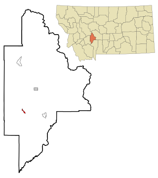
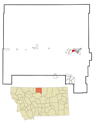
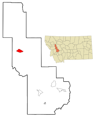
South Browning is a census-designated place (CDP) in Glacier County, Montana, United States. The population was 1,785 at the 2010 census. South Browning is a rural village on the Blackfeet Indian Reservation. It is bordered to the north by the town of Browning.

<span class="mw-page-title-main">Starr School, Montana</span> Census-designated place in Montana, United States

Starr School is a census-designated place (CDP) in Glacier County, Montana, United States. The population was 252 at the 2010 census.

<span class="mw-page-title-main">Rocky Boy's Agency, Montana</span> CDP in Montana, United States

Rocky Boy's Agency is a census-designated place (CDP) in Hill County, Montana, United States. The population was 355 at the 2010 census. The settlement developed around the US Indian agency for the Rocky Boy's Indian Reservation.

<span class="mw-page-title-main">Beaver Creek, Montana</span> Census-designated place in Montana, United States

Beaver Creek is a census-designated place (CDP) in Hill County, Montana, United States. The population was 271 at the 2010 census.

<span class="mw-page-title-main">Inverness, Montana</span> CDP in Montana, United States

Inverness is a census-designated place (CDP) in Hill County, Montana, United States. The population was 55 at the 2010 census. It was named after a city in Scotland.

<span class="mw-page-title-main">West Havre, Montana</span> Census-designated place in Montana, United States

West Havre is a census-designated place (CDP) in Hill County, Montana, United States. The population was 316 at the 2010 census, up from 284 in 2000.

<span class="mw-page-title-main">Ravalli, Montana</span> Place in Montana, United States

Ravalli is an unincorporated community in Lake County, Montana, United States. The population was 76 at the 2010 census, down from 119 in 2000. For statistical purposes, the United States Census Bureau has defined Ravalli as a census-designated place (CDP). In the early 1900s, the Pablo-Allard herd in Ravalli was said to be the largest collection of the bison remaining in the U.S. and played a critical role in the conservation of bison.

<span class="mw-page-title-main">Clinton, Montana</span> CDP in Montana, United States

Clinton is a census-designated place (CDP) in Missoula County, Montana, United States. It is part of the 'Missoula, Montana Metropolitan Statistical Area'. The CDP was named for General Sir Henry Clinton. The population was 1,052 at the 2010 census, an increase from its population of 549 in 2000.

<span class="mw-page-title-main">East Missoula, Montana</span> CDP in Montana, United States

East Missoula is a census-designated place (CDP) in Missoula County, Montana, United States. It is part of the Missoula, Montana Metropolitan Statistical Area'. The population was 2,157 at the 2010 census, an increase from its population of 2,070 in 2000.

<span class="mw-page-title-main">Heart Butte, Montana</span> Census–designated place in Pondera County, Montana

Heart Butte is a census-designated place (CDP) in Pondera County, Montana, United States. The population was 698 at the 2000 census. The town is on the Blackfeet Indian Reservation.

<span class="mw-page-title-main">Ovando, Montana</span> CDP in Montana, United States

Ovando is a census-designated place (CDP) in Powell County, Montana, United States. It is approximately fifty-four miles ENE of Missoula, Montana. The population was 71 at the 2000 census.

Box Elder is an unincorporated community and census-designated place (CDP) in Hill County in the U.S. state of Montana. The population was 87 at the 2010 census. The population was 794 at the 2000 census, but before 2010 the Box Elder CDP was split into the current much-smaller Box Elder CDP, while most of the former CDP area went into the new Rocky Boy West CDP. Box Elder is the headquarters of the Chippewa-Cree tribe.

<span class="mw-page-title-main">Parker School, Montana</span> Census-designated place in Montana, United States

Parker School is a census-designated place (CDP) in Hill and Chouteau counties in the U.S. state of Montana. The population was 340 at the 2010 census.

References

  1. "ArcGIS REST Services Directory". United States Census Bureau. Retrieved September 5, 2022.
  2. 1 2 "Geographic Identifiers: 2010 Demographic Profile Data (G001): North Browning CDP, Montana". American Factfinder. U.S. Census Bureau. Retrieved December 22, 2016.[ dead link ]
  3. "US Gazetteer files: 2010, 2000, and 1990". United States Census Bureau. February 12, 2011. Retrieved April 23, 2011.
  4. "Census of Population and Housing". Census.gov. Retrieved June 4, 2016.
  5. "U.S. Census website". United States Census Bureau . Retrieved January 31, 2008.
  6. "Directory of Montana Schools". Montana Office of Public Instruction. March 13, 2024. p. 119-120/319. Retrieved March 13, 2024.
  7. "2020 CENSUS - SCHOOL DISTRICT REFERENCE MAP: Glacier County, MT" (PDF). U.S. Census Bureau. pp. 2, 4 (PDF p. 3, 5/6). Retrieved March 13, 2024. - Text list