South Browning, Montana

Last updated

South Browning, Montana
Glacier County Montana Incorporated and Unincorporated areas South Browning Highlighted.svg
Location of South Browning, Montana
Coordinates: 48°33′0″N113°0′53″W / 48.55000°N 113.01472°W / 48.55000; -113.01472
Country United States
State Montana
County Glacier
Area
[1]
  Total2.37 sq mi (6.13 km2)
  Land2.34 sq mi (6.06 km2)
  Water0.03 sq mi (0.07 km2)
Elevation
4,393 ft (1,339 m)
Population
 (2020)
  Total1,970
  Density841.88/sq mi (325.00/km2)
Time zone UTC-7 (Mountain (MST))
  Summer (DST) UTC-6 (MDT)
Area code 406
FIPS code 30-69680
GNIS feature ID1867342

South Browning is a census-designated place (CDP) in Glacier County, Montana, United States. The population was 1,785 at the 2010 census. [2] South Browning is a rural village on the Blackfeet Indian Reservation. It is bordered to the north by the town of Browning.

Contents

Geography

South Browning is located at 48°33′0″N113°0′53″W / 48.55000°N 113.01472°W / 48.55000; -113.01472 (48.549869, -113.014594). [3]

According to the United States Census Bureau, the CDP has a total area of 2.37 square miles (6.14 km2), of which 2.31 square miles (5.99 km2) is land and 0.06 square miles (0.15 km2), or 2.48%, is water. [2]

Demographics

Historical population
CensusPop.Note
2020 1,970
U.S. Decennial Census [4]

As of the census [5] of 2000, there were 1,677 people, 475 households, and 391 families residing in the CDP. The population density was 719.4 inhabitants per square mile (277.8/km2). There were 526 housing units at an average density of 225.6 per square mile (87.1/km2). The racial makeup of the CDP was 2.44% White, 0.12% African American, 94.39% Native American, 0.54% from other races, and 2.50% from two or more races. Hispanic or Latino of any race were 2.15% of the population.

There were 475 households, out of which 53.3% had children under the age of 18 living with them, 42.5% were married couples living together, 32.0% had a female householder with no husband present, and 17.5% were non-families. 15.2% of all households were made up of individuals, and 2.9% had someone living alone who was 65 years of age or older. The average household size was 3.52 and the average family size was 3.90.

In the CDP, the population was spread out, with 43.2% under the age of 18, 10.3% from 18 to 24, 27.9% from 25 to 44, 14.6% from 45 to 64, and 4.0% who were 65 years of age or older. The median age was 22 years. For every 100 females, there were 93.2 males. For every 100 females age 18 and over, there were 79.8 males.

The median income for a household in the CDP was $12,130, and the median income for a family was $16,167. Males had a median income of $20,278 versus $18,068 for females. The per capita income for the CDP was $5,666. About 51.3% of families and 49.2% of the population were below the poverty line, including 52.8% of those under age 18 and 43.4% of those age 65 or over.

Related Research Articles

<span class="mw-page-title-main">Onyx, California</span> Census-designated place in California, United States

Onyx is a census-designated place (CDP) in Kern County, California, United States. Onyx is located 3.5 miles (6 km) east-northeast of Weldon in the South Fork Valley at an elevation of 2,795 feet (852 m). The population was 475 at the 2010 census, down from 476 at the 2000 census.

<span class="mw-page-title-main">Lake Almanor West, California</span> Census-designated place in California, United States

Lake Almanor West is a census-designated place (CDP) in Plumas County, California, United States. The population was 270 at the 2010 census, down from 329 at the 2000 census.

<span class="mw-page-title-main">Papaikou, Hawaii</span> Census-designated place in Hawaii, U.S.

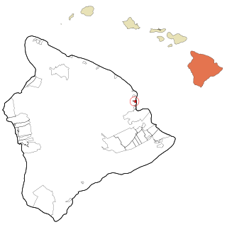
Papaikou is a census-designated place (CDP) in Hawaii County, Hawaii, United States, and is a few miles north of the county seat, Hilo. The population of Papaikou was 1,314 at the 2010 census, down from 1,414 at the 2000 census.

Deblois is a town in Washington County, Maine, United States. The town was named after T.A. Deblois, president of the Bank of Portland. The population was 74 at the 2020 census.

<span class="mw-page-title-main">Naval Academy, Maryland</span> Census-designated place in Maryland, United States

Naval Academy is a census-designated place (CDP) in Anne Arundel County, Maryland, United States, which covers the campus of the United States Naval Academy. The population was 4,802 at the 2010 census.

<span class="mw-page-title-main">East Falmouth, Massachusetts</span> Census-designated place in Massachusetts, United States

East Falmouth is a census-designated place (CDP) in the town of Falmouth in Barnstable County, Massachusetts, United States. It is located at the base of Massachusetts' "fishhook" peninsula. The population was 6,038 at the 2010 census, making East Falmouth the most populous of the six CDPs in Falmouth.

<span class="mw-page-title-main">Popponesset Island, Massachusetts</span> Census-designated place in Massachusetts, United States

Popponesset Island is an island and census-designated place (CDP) in the town of Mashpee in Barnstable County, Massachusetts, United States. The population was 220 at the 2010 census.

<span class="mw-page-title-main">Coram, Montana</span> Unincorporated community in Montana, United States

Coram is an unincorporated community and census-designated place (CDP) in Flathead County, Montana, United States. The population was 539 in 2010, up from 337 at the 2000 census. Coram lies 7 miles (11 km) southwest of the western entrance of Glacier National Park.

<span class="mw-page-title-main">North Browning, Montana</span> Census-designated place in Montana, United States

North Browning is a census-designated place (CDP) in Glacier County, Montana, United States. The population was 2,408 at the 2010 census.

<span class="mw-page-title-main">Starr School, Montana</span> Census-designated place in Montana, United States

Starr School is a census-designated place (CDP) in Glacier County, Montana, United States. The population was 252 at the 2010 census.

<span class="mw-page-title-main">Beaver Creek, Montana</span> Census-designated place in Montana, United States

Beaver Creek is a census-designated place (CDP) in Hill County, Montana, United States. The population was 271 at the 2010 census.

<span class="mw-page-title-main">Clinton, Montana</span> CDP in Montana, United States

Clinton is a census-designated place (CDP) in Missoula County, Montana, United States. It is part of the 'Missoula, Montana Metropolitan Statistical Area'. The CDP was named for General Sir Henry Clinton. The population was 1,052 at the 2010 census, an increase from its population of 549 in 2000.

<span class="mw-page-title-main">East Missoula, Montana</span> CDP in Montana, United States

East Missoula is a census-designated place (CDP) in Missoula County, Montana, United States. It is part of the 'Missoula, Montana Metropolitan Statistical Area'. The population was 2,157 at the 2010 census, an increase from its population of 2,070 in 2000.

<span class="mw-page-title-main">Ramblewood, New Jersey</span> Populated place in Burlington County, New Jersey, US

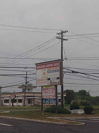
Ramblewood is an unincorporated community and census-designated place (CDP) located within Mount Laurel Township in Burlington County, in the U.S. state of New Jersey. As of the 2010 United States Census, the CDP's population was 5,907.

<span class="mw-page-title-main">Pine Ridge at Crestwood, New Jersey</span> Populated place in Ocean County, New Jersey, US

Pine Ridge at Crestwood is an unincorporated community and census-designated place (CDP) located within Manchester Township, in Ocean County, in the U.S. state of New Jersey. As of the 2010 United States Census, the CDP's population was 2,369.

<span class="mw-page-title-main">Navajo, New Mexico</span> Census-designated place in McKinley County, New Mexico, United States

Navajo is a census-designated place (CDP) on the Navajo Nation in McKinley County, New Mexico, United States. The population was 2,097 at the 2000 census. Navajo is the most Navajo town in the United States, with 95.04% of residents having full or partial Navajo ancestry.

<span class="mw-page-title-main">Pueblo of Sandia Village, New Mexico</span> Village in Sandoval County, New Mexico, US

Pueblo of Sandia Village is a census-designated place (CDP) in Sandoval County, New Mexico, United States. The population was 344 at the 2000 census. It is part of the Albuquerque Metropolitan Statistical Area.

<span class="mw-page-title-main">Warm Beach, Washington</span> CDP in Washington, United States

Warm Beach is a census-designated place (CDP) in Snohomish County, Washington, United States. The population was 2,437 at the 2010 census.

<span class="mw-page-title-main">Parker School, Montana</span> Census-designated place in Montana, United States

Parker School is a census-designated place (CDP) in Hill and Chouteau counties in the U.S. state of Montana. The population was 340 at the 2010 census.

Machias is a census-designated place (CDP) corresponding to the central village area within the town of Machias in Washington County, Maine, United States. The population of the CDP was 1,274 at the 2010 census.

References

  1. "ArcGIS REST Services Directory". United States Census Bureau. Retrieved September 5, 2022.
  2. 1 2 "Geographic Identifiers: 2010 Demographic Profile Data (G001): South Browning CDP, Montana". American Factfinder. U.S. Census Bureau. Retrieved December 22, 2016.[ dead link ]
  3. "US Gazetteer files: 2010, 2000, and 1990". United States Census Bureau. February 12, 2011. Retrieved April 23, 2011.
  4. "Census of Population and Housing". Census.gov. Retrieved June 4, 2016.
  5. "U.S. Census website". United States Census Bureau . Retrieved January 31, 2008.