Ekalaka, Montana

Last updated

Ekalaka, Montana [1]
Ekalaka MT Carter County Courthouse.jpg
Carter County Courthouse
Carter County Montana Incorporated and Unincorporated areas Ekalaka Highlighted.svg
Location of Ekalaka, Montana
Coordinates: 45°53′23″N104°33′02″W / 45.88972°N 104.55056°W / 45.88972; -104.55056
Country United States
State Montana
County Carter
Area
[2]
  Total1.03 sq mi (2.67 km2)
  Land1.03 sq mi (2.67 km2)
  Water0.00 sq mi (0.00 km2)
Elevation
[3]
3,425 ft (1,044 m)
Population
 (2020)
  Total399
  Density387.76/sq mi (149.64/km2)
Time zone UTC-7 (Mountain (MST))
  Summer (DST) UTC-6 (MDT)
ZIP code
59324
Area code 406
FIPS code 30-23650
GNIS feature ID2412470 [3]

Ekalaka is a town in and the county seat of Carter County, Montana, United States. [4] The population was 399 at the 2020 census. [5]

Contents

History

Ekalaka was named after a Sioux girl, Ijkalaka, [6] who was the wife of David Harrison Russell, a scout. [7]

Ijkalaka (Restless or Moving About) was an Oglala Lakota and the daughter of Wombalee We-chosh (Eagle Man). [6] She was born in 1858 on the Powder River, [6] while she was living with a cousin, Hi Kelly, at a ranch on Chugwater Creek, near Laramie, Wyoming. [6] She was 16 when she met Russell, who was a scout and frontiersman. [6]

The town was created by Russell on the edge of his ranch. A man named Carter bogged down in mud the spring of 1885 opened a saloon and is credited with saying "Anyplace in Montana is a good place to open a saloon". [8] The site became a trade center for cattle ranchers and sheepherders. [8] He put up houses to house freight workers and hunters who ran the local freight line (team and horses), and other added to it.

Geography

According to the United States Census Bureau, the town has a total area of 1.04 square miles (2.69 km2), all land. [9] The area is known for its sandstone rock and open plains. Nearby is the Custer National Forest. Russell Creek flows through town.

Climate

Ekalaka experiences a dry continental climate (Köppen Dfb) with cold, dry winters and hot, wetter summers.

Climate data for Ekalaka, Montana, 19912020 normals, extremes 1896present
MonthJanFebMarAprMayJunJulAugSepOctNovDecYear
Record high °F (°C)65
(18)
66
(19)
83
(28)
90
(32)
98
(37)
105
(41)
108
(42)
108
(42)
103
(39)
92
(33)
78
(26)
67
(19)
108
(42)
Mean maximum °F (°C)51.6
(10.9)
53.8
(12.1)
66.9
(19.4)
75.9
(24.4)
82.9
(28.3)
90.4
(32.4)
96.3
(35.7)
94.8
(34.9)
90.8
(32.7)
79.0
(26.1)
64.3
(17.9)
52.8
(11.6)
98.0
(36.7)
Mean daily maximum °F (°C)32.5
(0.3)
35.0
(1.7)
46.4
(8.0)
56.8
(13.8)
66.8
(19.3)
76.5
(24.7)
85.6
(29.8)
84.7
(29.3)
74.5
(23.6)
58.4
(14.7)
44.0
(6.7)
34.3
(1.3)
58.0
(14.4)
Daily mean °F (°C)21.6
(−5.8)
24.0
(−4.4)
34.1
(1.2)
43.7
(6.5)
53.6
(12.0)
63.2
(17.3)
71.2
(21.8)
70.0
(21.1)
60.0
(15.6)
45.8
(7.7)
32.8
(0.4)
23.6
(−4.7)
45.3
(7.4)
Mean daily minimum °F (°C)10.8
(−11.8)
13.1
(−10.5)
21.8
(−5.7)
30.7
(−0.7)
40.4
(4.7)
49.9
(9.9)
56.8
(13.8)
55.3
(12.9)
45.6
(7.6)
33.2
(0.7)
21.5
(−5.8)
12.9
(−10.6)
32.7
(0.4)
Mean minimum °F (°C)−17.3
(−27.4)
−11.6
(−24.2)
−3.4
(−19.7)
12.6
(−10.8)
24.3
(−4.3)
36.8
(2.7)
44.5
(6.9)
40.2
(4.6)
29.4
(−1.4)
12.8
(−10.7)
−2.4
(−19.1)
−13.3
(−25.2)
−24.1
(−31.2)
Record low °F (°C)−44
(−42)
−43
(−42)
−32
(−36)
−11
(−24)
8
(−13)
27
(−3)
30
(−1)
26
(−3)
13
(−11)
−15
(−26)
−30
(−34)
−43
(−42)
−44
(−42)
Average precipitation inches (mm)0.58
(15)
0.66
(17)
0.95
(24)
1.86
(47)
3.21
(82)
2.95
(75)
2.10
(53)
1.35
(34)
1.60
(41)
1.58
(40)
0.76
(19)
0.51
(13)
18.11
(460)
Average snowfall inches (cm)6.5
(17)
9.0
(23)
8.8
(22)
5.3
(13)
2.6
(6.6)
0.0
(0.0)
0.0
(0.0)
0.0
(0.0)
0.1
(0.25)
2.4
(6.1)
6.2
(16)
7.5
(19)
48.4
(122.95)
Average precipitation days (≥ 0.01 in)7.47.27.48.411.310.77.96.76.58.06.77.195.3
Average snowy days (≥ 0.1 in)6.66.84.92.20.70.00.00.00.11.64.46.734.0
Source 1: NOAA [10]
Source 2: National Weather Service [11]

Demographics

Historical population
CensusPop.Note
1920 433
1930 4759.7%
1940 71951.4%
1950 90425.7%
1960 738−18.4%
1970 663−10.2%
1980 620−6.5%
1990 439−29.2%
2000 410−6.6%
2010 332−19.0%
2020 39920.2%
U.S. Decennial Census [12] [5]

2010 census

At the 2010 census, [13] there were 332 people, 176 households and 87 families residing in the town. The population density was 319.2 inhabitants per square mile (123.2/km2). There were 266 housing units at an average density of 255.8 per square mile (98.8/km2). The racial makeup of the town was 96.4% White, 1.2% Native American, 0.3% from other races, and 2.1% from two or more races. Hispanic or Latino of any race were 1.2% of the population.

There were 176 households, of which 17.0% had children under the age of 18 living with them, 39.8% were married couples living together, 6.8% had a female householder with no husband present, 2.8% had a male householder with no wife present, and 50.6% were non-families. 45.5% of all households were made up of individuals, and 22.8% had someone living alone who was 65 years of age or older. The average household size was 1.82 and the average family size was 2.52.

The median age was 54 years. 15.1% of residents were under the age of 18; 6.8% were between the ages of 18 and 24; 12.3% were from 25 to 44; 34.2% were from 45 to 64; and 31.3% were 65 years of age or older. The gender makeup of the town was 47.0% male and 53.0% female.

2000 census

At the 2000 census, [14] there were 410 people, 195 households and 109 families residing in the town. The population density was 391.5 inhabitants per square mile (151.2/km2). There were 287 housing units at an average density of 274.1 per square mile (105.8/km2). The racial makeup of the town was 99.02% White, 0.49% Native American, and 0.49% from two or more races. Hispanic or Latino of any race were 0.49% of the population.

There were 195 households, of which 21.5% had children under the age of 18 living with them, 44.6% were married couples living together, 8.7% had a female householder with no husband present, and 43.6% were non-families. 42.1% of all households were made up of individuals, and 25.6% had someone living alone who was 65 years of age or older. The average household size was 2.02 and the average family size was 2.73.

21.7% of the population were under the age of 18, 2.4% from 18 to 24, 21.7% from 25 to 44, 24.1% from 45 to 64, and 30.0% who were 65 years of age or older. The median age was 49 years. For every 100 females there were 85.5 males. For every 100 females age 18 and over, there were 80.3 males.

The median household income was $19,432 and the median family income was $27,750. Males had a median income of $22,656 and females $18,125. The per capita income $13,667. About 7.1% of families and 12.2% of the population were below the poverty line, including 8.5% of those under age 18 and 15.0% of those age 65 or over.

Arts and culture

Ekalaka is part of the Montana Dinosaur Trail, and is home to the Carter County Museum, which is known for its dinosaur collection. [15]

Ekalaka Public Library serves the town. [16]

Education

Ekalaka Public Schools educates students from kindergarten through 12th grade. There is the Ekalaka Elementary District and Carter County High School. [17] They are known as the Bulldogs. [18]

Media

The Ekalaka Eagle is the official newspaper of Carter County. [19] It is published weekly both in print and online.

Infrastructure

Ekalaka is the southern start of Montana Highway 7 and the northern end of Montana Secondary Highway 323.

Ekalaka Airport is a public use airport located 2 miles southeast of town. [20]

Notable person

Related Research Articles

<span class="mw-page-title-main">Carter County, Montana</span> County in Montana, United States

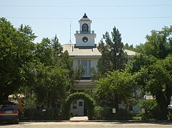
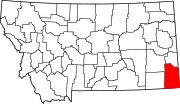
Carter County is a county located in the U.S. state of Montana. As of the 2020 census, the population was 1,415, making it the seventh-least populous county in Montana. The county seat is Ekalaka.

<span class="mw-page-title-main">Sardis City, Alabama</span> Town in Alabama, United States

Sardis City is a town in Etowah and Marshall counties in the U.S. state of Alabama. It is part of the Gadsden Metropolitan Statistical Area. It originally incorporated in May 1963 under the name of "Sardis". It became Sardis City in the 1980s. At the 2020 census, the population was 1,814.

<span class="mw-page-title-main">River Forest, Indiana</span> Town in Indiana, United States

River Forest is a town in Anderson Township, Madison County, Indiana, United States. It is part of the Indianapolis–Carmel–Anderson metropolitan statistical area. The population was 26 at the 2020 census.

<span class="mw-page-title-main">Uniondale, Indiana</span> Town in Indiana, United States

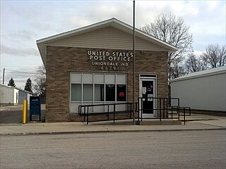
Uniondale is a town in Union and Rockcreek townships, Wells County, in the U.S. state of Indiana. The population was 310 at the 2010 census, down from 271 at the 2020 Census.

<span class="mw-page-title-main">Crystal, Maine</span> Town in the state of Maine, United States

Crystal is a town in Aroostook County, Maine, United States. The population was 248 at the 2020 census.

<span class="mw-page-title-main">Grand Isle, Maine</span> Town in the state of Maine, United States

Grand Isle is a town in Aroostook County, Maine, United States. The population was 366 at the 2020 census. The village of Grand Isle is in the northwestern part of the town.

<span class="mw-page-title-main">Masardis, Maine</span> Town in Maine, United States

Masardis is a town in Aroostook County, Maine, United States. The population was 204 at the 2020 census.

<span class="mw-page-title-main">New Canada, Maine</span> Town in the state of Maine, United States

New Canada is a town in Aroostook County, Maine, United States. The population was 310 at the 2020 census.

<span class="mw-page-title-main">Sherman, Maine</span> Town in the state of Maine, United States

Sherman is a town in Aroostook County, Maine, United States. The population was 815 at the 2020 census.

<span class="mw-page-title-main">Washburn, Maine</span> Town in the state of Maine, United States

Washburn is a town in Aroostook County, Maine, United States. It was incorporated on February 25, 1861, and named after Israel Washburn, the governor of Maine at the time. The population was 1,527 at the 2020 census. Benjamin C. Wilder House, which was built in 1852, is located on Main Street in Washburn and predates the town's incorporation by nine years.

Otis is a town in Hancock County, Maine, United States. The population was 673 at the 2020 census.

Springfield is a town in Penobscot County, Maine, United States. The population was 293 at the 2020 census.

<span class="mw-page-title-main">Troy, Maine</span> Town in the state of Maine, United States

Troy is a town in Waldo County, Maine, United States. The population was 1,018 at the 2020 census.

<span class="mw-page-title-main">Carter, Montana</span> Census-designated place in Montana, United States

Carter is a census-designated place (CDP) in Chouteau County, Montana, United States. The population was 58 at the 2010 census.

<span class="mw-page-title-main">Flaxville, Montana</span> Town in Montana, United States

Flaxville is a town in Daniels County, Montana, United States. The population was 63 at the 2020 census.

<span class="mw-page-title-main">Drummond, Montana</span> Town in Montana, United States

Drummond is a town in Granite County, Montana, United States. The population was 272 at the 2020 census.

<span class="mw-page-title-main">Westby, Montana</span> Town in Montana, United States

Westby is a town in Sheridan County, Montana, United States. The population was 167 at the 2020 census.

<span class="mw-page-title-main">Wibaux, Montana</span> Town in Montana, United States

Wibaux is a town in and the county seat of Wibaux County, Montana, United States. It is the only incorporated town in Wibaux County. The population was 462 at the 2020 census.

<span class="mw-page-title-main">Dickson, Oklahoma</span> Town in Oklahoma, United States

Dickson is a town in Carter County, Oklahoma, United States. The population was 1,207 at the 2010 census. It is part of the Ardmore, Oklahoma Micropolitan Statistical Area.

<span class="mw-page-title-main">Randolph, Wisconsin</span> Village in Wisconsin, United States

Randolph is a village in Columbia and Dodge Counties in the U.S. state of Wisconsin. The population was 1,811 at the 2010 census. Of this, 1,339 were in Dodge County, and 472 were in Columbia County. The village is located at the southeast corner of the Town of Randolph in Columbia County, although only a tiny portion of the village lies within the town. Most of the village lies within the Town of Westford in Dodge County. Small portions also lie within the Town of Fox Lake to the north and the Town of Courtland in Columbia County.

References

  1. TravelMT. "Ekalaka" . Retrieved November 17, 2011.
  2. "ArcGIS REST Services Directory". United States Census Bureau. Retrieved September 5, 2022.
  3. 1 2 U.S. Geological Survey Geographic Names Information System: Ekalaka, Montana
  4. "Find a County". National Association of Counties. Archived from the original on July 12, 2012. Retrieved June 7, 2011.
  5. 1 2 "U.S. Census website". United States Census Bureau . Retrieved November 2, 2021.
  6. 1 2 3 4 5 Speiser, James; Speiser, Mildred; Gilman, Johnnie; Gilman, Gertrude (1975). Changing West. Miles City, MT: H&T Quality Printing.
  7. "Montana Place Names: E-G" . Retrieved February 4, 2008. condensed from the 1957 Montana Almanac
  8. 1 2 "Montana: Official State Travel Site" . Retrieved December 31, 2011.
  9. "US Gazetteer files 2010". United States Census Bureau. Archived from the original on January 25, 2012. Retrieved December 18, 2012.
  10. "U.S. Climate Normals Quick Access". National Oceanic and Atmospheric Administration. Retrieved August 5, 2022.
  11. "NOAA Online Weather Data". National Weather Service. Retrieved August 5, 2022.
  12. "Census of Population and Housing". Census.gov. Retrieved June 4, 2015.
  13. "U.S. Census website". United States Census Bureau . Retrieved December 18, 2012.
  14. "U.S. Census website". United States Census Bureau . Retrieved January 31, 2008.
  15. "Ekalaka: A home where dinosaurs roamed, and the coffee game they do play" . Retrieved December 15, 2014.
  16. "Ekalaka Public Library" . Retrieved April 12, 2021.
  17. "Ekalaka Public Schools" . Retrieved April 12, 2021.
  18. "Member Schools". Montana High School Association. Retrieved April 19, 2021.
  19. "About the Ekalaka Eagle". The Ekalaka Eagle. Retrieved September 3, 2023.
  20. "97M Ekalaka". FAA. Retrieved September 3, 2023.