Superior, Montana

Last updated

Superior, Montana
Mineral County Montana Incorporated and Unincorporated areas Superior Highlighted.svg
Location of Superior, Montana
Coordinates: 47°11′36″N114°53′25″W / 47.19333°N 114.89028°W / 47.19333; -114.89028
Country United States
State Montana
County Mineral
Area
[1]
  Total1.07 sq mi (2.77 km2)
  Land0.95 sq mi (2.47 km2)
  Water0.12 sq mi (0.30 km2)
Elevation
[2]
2,720 ft (830 m)
Population
 (2020)
  Total830
  Density869.11/sq mi (335.59/km2)
Time zone UTC-7 (Mountain (MST))
  Summer (DST) UTC-6 (MDT)
ZIP code
59872
Area code 406
FIPS code 30-72625
GNIS feature ID2413356 [2]
Website https://townofsuperiormontana.org/

Superior is a town in, and the county seat of, Mineral County, Montana, United States. [3] The population was 830 at the 2020 census. [4]

Contents

History

Superior was named after its founders' hometown of Superior, Wisconsin in 1869. [5] The post office was established in 1871 after Mineral County became the site of one of the largest gold strikes that helped settle the West.

In the 1860s and 70s, several thousand miners converged on Cedar Creek. Mining has remained central to the economy, along with the development of logging and United States Forest Service activities.

In 1908, the Superior Hotel received the first Bibles to be placed in hotel rooms by The Gideons. [5] This is noted on a historic plaque on Mullan Road.

The Mineral County Museum is located in Superior. [6]

Geography

According to the United States Census Bureau, the town has a total area of 1.17 square miles (3.03 km2), of which 1.05 square miles (2.72 km2) is land and 0.12 square miles (0.31 km2) is water. [7]

Superior is located within the Bitterroot Range of mountains. The Clark Fork flows through downtown, heading north towards St. Regis and ultimately emptying into Lake Pend Oreille near Cabinet, Idaho. The mountains to the west of Superior along the Montana/Idaho border receive a large amount of precipitation annually, mostly due to the amount of snow in the winter months. Nearby Lookout Pass Ski and Recreation Area receives approximately 400 in (1,000 cm) of snow each winter. The snow pack melts throughout the spring and summer months, feeding the many mountain streams and creeks with water. All the water eventually reaches the Clark Fork in the valley below, where Superior is located.[ citation needed ]

Climate

Climate data for Superior, Montana (1981–2010)
MonthJanFebMarAprMayJunJulAugSepOctNovDecYear
Mean daily maximum °F (°C)35.9
(2.2)
42.7
(5.9)
52.6
(11.4)
61.0
(16.1)
69.7
(20.9)
77.1
(25.1)
86.7
(30.4)
86.6
(30.3)
75.6
(24.2)
60.3
(15.7)
42.8
(6.0)
33.0
(0.6)
60.3
(15.7)
Mean daily minimum °F (°C)21.3
(−5.9)
22.5
(−5.3)
27.8
(−2.3)
32.7
(0.4)
39.4
(4.1)
45.9
(7.7)
50.4
(10.2)
49.3
(9.6)
41.8
(5.4)
33.7
(0.9)
27.5
(−2.5)
20.2
(−6.6)
34.4
(1.3)
Average precipitation inches (mm)1.15
(29)
1.13
(29)
1.22
(31)
1.29
(33)
1.97
(50)
2.06
(52)
0.98
(25)
1.33
(34)
1.19
(30)
1.29
(33)
1.81
(46)
1.52
(39)
16.92
(430)
Average snowfall inches (cm)2.0
(5.1)
2.6
(6.6)
0.3
(0.76)
0.1
(0.25)
0.0
(0.0)
0.0
(0.0)
0.0
(0.0)
0.0
(0.0)
0.0
(0.0)
0.0
(0.0)
3.5
(8.9)
5.7
(14)
14.2
(36)
Source: NOAA [8]

Demographics

Historical population
CensusPop.Note
1950 626
1960 1,24298.4%
1970 993−20.0%
1980 1,0546.1%
1990 881−16.4%
2000 8931.4%
2010 812−9.1%
2020 8302.2%
U.S. Decennial Census [9] [4]

2010 census

As of the census [10] of 2010, there were 812 people, 386 households, and 220 families residing in the town. The population density was 773.3 inhabitants per square mile (298.6/km2). There were 431 housing units at an average density of 410.5 per square mile (158.5/km2). The racial makeup of the town was 93.8% White, 0.7% African American, 1.2% Native American, 1.6% Asian, 0.1% from other races, and 2.5% from two or more races. Hispanic or Latino of any race were 2.3% of the population.

There were 386 households, of which 20.2% had children under the age of 18 living with them, 43.0% were married couples living together, 9.6% had a female householder with no husband present, 4.4% had a male householder with no wife present, and 43.0% were non-families. 37.6% of all households were made up of individuals, and 17.8% had someone living alone who was 65 years of age or older. The average household size was 2.05 and the average family size was 2.64.

The median age in the town was 52.1 years. 15.9% of residents were under the age of 18; 6.9% were between the ages of 18 and 24; 15.9% were from 25 to 44; 35.4% were from 45 to 64; and 25.9% were 65 years of age or older. The gender makeup of the town was 48.5% male and 51.5% female.

2000 census

As of the census [11] of 2000, there were 893 people, 358 households, and 218 families residing in the town. The population density was 823.3 inhabitants per square mile (317.9/km2). There were 410 housing units at an average density of 378.0 per square mile (145.9/km2). The racial makeup of the town was 92.83% White, 0.11% African American, 2.91% Native American, 0.78% Asian, 0.11% from other races, and 3.25% from two or more races. Hispanic or Latino of any race were 1.90% of the population.

There were 358 households, out of which 29.1% had children under the age of 18 living with them, 47.8% were married couples living together, 9.2% had a female householder with no husband present, and 39.1% were non-families. 33.8% of all households were made up of individuals, and 12.8% had someone living alone who was 65 years of age or older. The average household size was 2.32 and the average family size was 2.93.

In the town, the population was spread out, with 25.3% under the age of 18, 6.9% from 18 to 24, 26.2% from 25 to 44, 24.0% from 45 to 64, and 17.6% who were 65 years of age or older. The median age was 40 years. For every 100 females there were 99.8 males. For every 100 females age 18 and over, there were 99.1 males.

The median income for a household in the town was $25,333, and the median income for a family was $31,650. Males had a median income of $24,688 versus $18,750 for females. The per capita income for the town was $14,154. About 10.4% of families and 17.0% of the population were below the poverty line, including 23.0% of those under age 18 and 7.4% of those age 65 or over.

Education

The Superior School District educates students from kindergarten to 12th grade. There are three schools: Elementary (K-6), Middle (7-8), and Superior High School (9-12). The high school had 110 student enrolled during the 2021-2022 school year. [12]

The Mineral County Public Library is located in Superior. [13] It has branches in Alberton and St. Regis.

Media

The Mineral Independent is the newspaper serving Mineral County. It is printed weekly and also has an e-edition. [14]

The FM radio station KENR is licensed in Superior. [15]

Infrastructure

Interstate 90 passes the town at the southern border. Access is via exit 47.

Mineral County Airport is a county-owned public-use airport located two miles (3.7 km) southeast of town. [16]

Notable people

Related Research Articles

<span class="mw-page-title-main">Mineral County, Montana</span> County in Montana, United States

Mineral County is a county located in the U.S. state of Montana. As of the 2020 census, the population was 4,535. Its county seat is Superior.

Greenwood is a town in Oxford County, Maine, United States. The population was 774 at the 2020 census. The town was named for surveyor Alexander Greenwood. The village of Locke Mills, on State Route 26 in the northern part of Greenwood, is the town's urban center and largest settlement.

<span class="mw-page-title-main">Townsend, Montana</span> City in Montana, United States

Townsend is a city in and the county seat of Broadwater County, Montana, United States. The population was 1,787 at the 2020 census.

<span class="mw-page-title-main">Cascade, Montana</span> Town in Cascade County, Montana, United States

Cascade is a town in Cascade County, Montana, United States. The population was 600 at the 2020 census. It is part of the Great Falls, Montana Metropolitan Statistical Area, which in 2020 had a population of 84,414. Cascade was incorporated in 1911.

<span class="mw-page-title-main">Geraldine, Montana</span> Town in Montana, United States

Geraldine is a town in Chouteau County, Montana, United States. The population was 207 at the 2020 census. The area around the town is an agricultural, largely wheat-producing, region.

<span class="mw-page-title-main">Winifred, Montana</span> Town in Montana, United States

Winifred is a small town in rural north-central Fergus County, Montana, United States. It was founded in 1913 and provides services for its region's populace. The town population was 172 at the 2020 census. The current mayor is Travis Willson.

<span class="mw-page-title-main">Lakeside, Montana</span> Unincorporated community in Montana, United States

Lakeside is an unincorporated area and census-designated place (CDP) in Flathead County, Montana, United States. The population was 2,705 at the 2020 census, up from 2,669 in 2010.

<span class="mw-page-title-main">Ryegate, Montana</span> Town in Montana, United States

Ryegate is a town in, and the county seat of, Golden Valley County, Montana, United States. The population was 223 at the 2020 census. Ryegate is situated on the north bank of the Musselshell River.

<span class="mw-page-title-main">Alberton, Montana</span> Town in Montana, United States

Alberton is a town in Mineral County, Montana, United States. The population was 452 at the 2020 census.
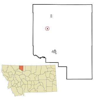
 Alberton was the location of a major chlorine chemical release in 1996. It is the home of Northwest Indian Bible School, a Bible-training institution founded and operated by the Allegheny Wesleyan Methodist Connection.

<span class="mw-page-title-main">De Borgia, Montana</span> CDP in Montana, United States

De Borgia is a census-designated place (CDP) in Mineral County, Montana, United States. The population was 69 at the 2000 census.

<span class="mw-page-title-main">St. Regis, Montana</span> Census-designated place in Montana, United States

St. Regis or Saint Regis is an unincorporated community and census-designated place (CDP) in Mineral County, Montana. The population was 313 at the time of the 2020 census.

<span class="mw-page-title-main">Dixon, Montana</span> CDP in Montana, United States

Dixon is a census-designated place (CDP) in Sanders County, Montana, United States. The population was 221 at the 2020 census.

<span class="mw-page-title-main">Hot Springs, Montana</span> Town in Montana, United States

Hot Springs is a town on the Flathead Indian Reservation in Sanders County, Montana, United States. The population was 557 at the 2020 census.

<span class="mw-page-title-main">Thompson Falls, Montana</span> City in Montana, United States

Thompson Falls is a city in and the county seat of Sanders County, Montana. The population was 1,336 at the time of the 2020 census.

<span class="mw-page-title-main">Broadview, Montana</span> Town in Montana, United States

Broadview is a town in Yellowstone County, Montana, United States. The population was 139 at the 2020 census.

<span class="mw-page-title-main">Mineral City, Ohio</span> Village in Ohio, United States

Mineral City is a village in Tuscarawas County, Ohio, United States. The population was 652 at the 2020 census.

<span class="mw-page-title-main">Brunswick, Vermont</span> Town in Vermont, United States

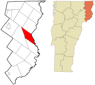
Brunswick is a town in Essex County, Vermont, United States. The town was named after Prince Karl Wilhelm Ferdinand of Brunswick-Lunenburg. The population was 88 at the 2020 census. It is part of the Berlin, NH-VT Micropolitan Statistical Area. Brunswick is home to six mineral springs that made the town a popular resort destination in the 19th century. The land the springs are on is now owned by the Abenaki people.

<span class="mw-page-title-main">Elk Garden, West Virginia</span> Town in West Virginia, United States

Elk Garden is a town in Mineral County, West Virginia, United States. It is part of the 'Cumberland, MD-WV Metropolitan Statistical Area'. The population was 211 at the 2020 census. Elk Garden High School was consolidated into Keyser High School in 1997. However the Primary School is still in session, offering classes from Pre-Kindergarten through the fifth grade. The school mascot is the Elk Garden Stags. Elk Garden was incorporated in 1890 by the Mineral County Circuit Court. It is named for an elk lick near the original town site.

<span class="mw-page-title-main">Montana, Wisconsin</span> Town in Wisconsin, United States

Montana is a town in Buffalo County in the U.S. state of Wisconsin. The population was 284 at the 2010 census. The community of Montana is located in the town.
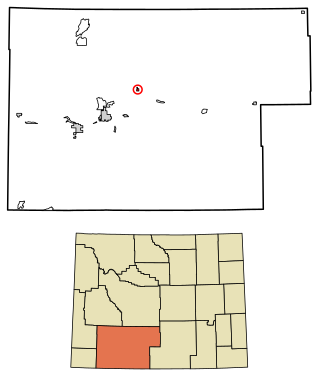
<span class="mw-page-title-main">Oakland, Douglas County, Wisconsin</span> Town in Wisconsin, United States

Oakland is a town in Douglas County, Wisconsin, United States. The population was 1,144 at the 2000 census.

References

  1. "ArcGIS REST Services Directory". United States Census Bureau. Retrieved September 5, 2022.
  2. 1 2 U.S. Geological Survey Geographic Names Information System: Superior, Montana
  3. "Find a County". National Association of Counties. Retrieved June 7, 2011.
  4. 1 2 "U.S. Census website". United States Census Bureau . Retrieved November 2, 2021.
  5. 1 2 "Superior". Montana Place Names Companion. Montana Historical Society. Retrieved April 9, 2021.
  6. "Mineral County Museum". Montana Office of Tourism. Retrieved April 10, 2021.
  7. "US Gazetteer files 2010". United States Census Bureau. Archived from the original on February 20, 2011. Retrieved December 18, 2012.
  8. "NOWData - NOAA Online Weather Data". National Oceanic and Atmospheric Administration . Retrieved May 5, 2013.
  9. "Census of Population and Housing". Census.gov. Retrieved June 4, 2015.
  10. "U.S. Census website". United States Census Bureau . Retrieved December 18, 2012.
  11. "U.S. Census website". United States Census Bureau . Retrieved January 31, 2008.
  12. "Superior High School". National Center for Education Statistics. Retrieved November 11, 2023.
  13. "Mineral County Public Library". Mineral County Public Library. Retrieved April 12, 2021.
  14. "Latest News". Clark Fork Valley Press/Mineral Independent. Retrieved August 31, 2023.
  15. "KENR". FCC. Retrieved November 11, 2023.
  16. "9SF". FAA. Retrieved August 31, 2023.