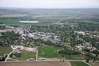
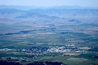
Geography
White Sulphur Springs is in central Meagher County, along combined U.S. Routes 12 and 89, which pass through the city as Main Street and 3rd Avenue. US 12 leads east 57 miles (92 km) to Harlowton and southwest 42 miles (68 km) to Townsend, while US 89 leads north 40 miles (64 km) to Neihart and south 71 miles (114 km) to Livingston.
According to the U.S. Census Bureau, White Sulphur Springs has a total area of 0.99 square miles (2.56 km2), all of it recorded as land. [1] Hot Springs Creek rises in the center of town at a local hotel, which offers soaking in the mineralized hot springs. The North Fork Smith River crosses the northwest part of town. The Smith River is a north-flowing tributary of the Missouri.
The Castle Mountains are southeast of town. Newlan Creek Reservoir [7] is 13 miles (21 km) by road to the north, at the foot of the Little Belt Mountains, and Lake Sutherlin [8] is 10 miles (16 km) to the northeast along US 12. The lakes provide recreational water activities, including fishing for trout, burbot, and kokanee salmon.
White Sulphur is an anchor for the Kings Hill Scenic Byway, a 71-mile (114 km) drive which passes through the Little Belt Mountains in the Lewis and Clark National Forest. [9]
Climate
| Climate data for White Sulphur Springs, Montana, 1991–2020 normals, extremes 1894–present |
|---|
| Month | Jan | Feb | Mar | Apr | May | Jun | Jul | Aug | Sep | Oct | Nov | Dec | Year |
|---|
| Record high °F (°C) | 60
(16) | 78
(26) | 85
(29) | 89
(32) | 96
(36) | 98
(37) | 103
(39) | 100
(38) | 96
(36) | 87
(31) | 70
(21) | 63
(17) | 103
(39) |
|---|
| Mean maximum °F (°C) | 49.8
(9.9) | 50.9
(10.5) | 60.7
(15.9) | 71.1
(21.7) | 78.7
(25.9) | 86.1
(30.1) | 91.8
(33.2) | 91.8
(33.2) | 86.6
(30.3) | 75.8
(24.3) | 60.9
(16.1) | 49.4
(9.7) | 93.6
(34.2) |
|---|
| Mean daily maximum °F (°C) | 33.4
(0.8) | 34.6
(1.4) | 44.6
(7.0) | 52.9
(11.6) | 62.7
(17.1) | 71.3
(21.8) | 81.6
(27.6) | 81.4
(27.4) | 70.6
(21.4) | 56.3
(13.5) | 41.7
(5.4) | 32.6
(0.3) | 55.3
(12.9) |
|---|
| Daily mean °F (°C) | 23.4
(−4.8) | 23.7
(−4.6) | 32.7
(0.4) | 39.7
(4.3) | 48.7
(9.3) | 56.7
(13.7) | 64.8
(18.2) | 64.0
(17.8) | 54.7
(12.6) | 42.8
(6.0) | 31.1
(−0.5) | 23.0
(−5.0) | 42.1
(5.6) |
|---|
| Mean daily minimum °F (°C) | 13.4
(−10.3) | 12.9
(−10.6) | 20.8
(−6.2) | 26.6
(−3.0) | 34.7
(1.5) | 42.1
(5.6) | 48.1
(8.9) | 46.5
(8.1) | 38.7
(3.7) | 29.3
(−1.5) | 20.4
(−6.4) | 13.4
(−10.3) | 28.9
(−1.7) |
|---|
| Mean minimum °F (°C) | −12.5
(−24.7) | −9.7
(−23.2) | 1.2
(−17.1) | 13.3
(−10.4) | 23.7
(−4.6) | 33.0
(0.6) | 39.7
(4.3) | 36.7
(2.6) | 27.1
(−2.7) | 11.2
(−11.6) | −1.2
(−18.4) | −9.4
(−23.0) | −22.3
(−30.2) |
|---|
| Record low °F (°C) | −42
(−41) | −43
(−42) | −33
(−36) | −7
(−22) | 8
(−13) | 22
(−6) | 28
(−2) | 23
(−5) | 12
(−11) | −23
(−31) | −39
(−39) | −46
(−43) | −46
(−43) |
|---|
| Average precipitation inches (mm) | 0.51
(13) | 0.34
(8.6) | 0.71
(18) | 1.44
(37) | 2.08
(53) | 2.52
(64) | 1.36
(35) | 1.21
(31) | 1.04
(26) | 0.86
(22) | 0.44
(11) | 0.53
(13) | 13.04
(331.6) |
|---|
| Average snowfall inches (cm) | 7.9
(20) | 6.6
(17) | 10.1
(26) | 3.9
(9.9) | 1.1
(2.8) | 0.0
(0.0) | 0.0
(0.0) | 0.0
(0.0) | 1.2
(3.0) | 3.4
(8.6) | 4.4
(11) | 7.5
(19) | 46.1
(117.3) |
|---|
| Average extreme snow depth inches (cm) | 5.4
(14) | 4.1
(10) | 4.8
(12) | 2.6
(6.6) | 0.4
(1.0) | 0.0
(0.0) | 0.0
(0.0) | 0.0
(0.0) | 0.6
(1.5) | 1.5
(3.8) | 3.6
(9.1) | 5.0
(13) | 8.3
(21) |
|---|
| Average precipitation days (≥ 0.01 in) | 4.9 | 3.9 | 5.7 | 8.1 | 10.7 | 12.2 | 7.9 | 7.8 | 6.6 | 6.9 | 5.3 | 4.5 | 84.5 |
|---|
| Average snowy days (≥ 0.1 in) | 4.2 | 3.3 | 3.6 | 1.4 | 0.1 | 0.0 | 0.0 | 0.0 | 0.3 | 1.0 | 2.7 | 4.2 | 20.8 |
|---|
| Source 1: NOAA [10] [11] |
| Source 2: National Weather Service (snow/snow days/snow depth 1981–2010) [12] |
Demographics
2010 census
At the 2010 census there were 939 people in 433 households, including 255 families, in the city. The population density was 929.7 inhabitants per square mile (359.0/km2). There were 563 housing units at an average density of 557.4 per square mile (215.2/km2). The racial makeup of the city was 97.2% White, 0.1% African American, 0.3% Native American, 0.4% Asian, 0.2% from other races, and 1.7% from two or more races. Hispanic or Latino of any race were 1.4%. [14]
Of the 433 households 22.2% had children under the age of 18 living with them, 49.4% were married couples living together, 7.9% had a female householder with no husband present, 1.6% had a male householder with no wife present, and 41.1% were non-families. 37.4% of households were one person and 19.6% were one person aged 65 or older. The average household size was 2.13 and the average family size was 2.75.
The median age was 51.2 years. 19% of residents were under the age of 18; 5.1% were between the ages of 18 and 24; 18% were from 25 to 44; 31.4% were from 45 to 64; and 26.3% were 65 or older. The gender makeup of the city was 49.8% male and 50.2% female.
2000 census
At the 2000 census there were 984 people in 443 households, including 265 families, in the city. The population density was 1,069.1 inhabitants per square mile (412.8/km2). There were 567 housing units at an average density of 616.0 per square mile (237.8/km2). The racial makeup of the city was 96.24% White, 1.42% Native American, 0.20% Asian, 0.10% Pacific Islander, 0.51% from other races, and 1.52% from two or more races. Hispanic or Latino of any race were 1.93%. [15]
Of the 443 households 25.3% had children under the age of 18 living with them, 48.1% were married couples living together, 8.4% had a female householder with no husband present, and 40.0% were non-families. 37.0% of households were one person and 17.8% were one person aged 65 or older. The average household size was 2.16 and the average family size was 2.84.
The age distribution was 22.4% under the age of 18, 6.9% from 18 to 24, 22.5% from 25 to 44, 26.9% from 45 to 64, and 21.3% 65 or older. The median age was 44 years. For every 100 females there were 94.9 males. For every 100 females age 18 and over, there were 92.9 males.
The median household income was $28,229 and the median family income was $34,342. Males had a median income of $23,403 versus $13,929 for females. The per capita income for the city was $13,836. About 11.6% of families and 13.3% of the population were below the poverty line, including 16.5% of those under age 18 and 11.0% of those age 65 or over.
Arts and culture
The Castle Museum and Carriage House is a combination of a mansion tour and the Meagher County Museum. [16] The Victorian style mansion has been decorated with period style artifacts. The carriage house was built in the 1990s to display a variety of carriages, sleds, a stagecoach, and other mementos. [16]
The Charles M. Bair Family Museum, 35 miles (56 km) away, is the former home of Bair, one of the largest sheep ranchers in the United States in the early 1900s. [17] The 11,000 sq ft home is filled with artifacts from the family. Additionally the museum covers 7,300 sq ft with art galleries and additional artifacts from the family's collections. [18]
Meagher County City Library serves the area. [19]
The Red Ants Pants Music Festival is held the last weekend in July. [20] Internationally famous musicians have performed at the festival such as Merle Haggard, [21] Lucinda Williams, [22] and Brandi Carlile. [23]

Wheatland County is a county in the U.S. state of Montana. As of the 2020 census, the population was 2,069. Its county seat is Harlowton. Wheatland County was established on February 22, 1917, with areas partitioned from Meagher and Sweet Grass counties. It was named for the abundant wheat-growing areas across the center portion of the new county's area.

Park County is a county in the U.S. state of Montana. At the 2020 census, the population was 17,191. Its county seat is Livingston. A small part of Yellowstone National Park is in the southern part of the county.

Musselshell County is a county in south-central Montana. As of the 2020 census, the population was 4,730. Its county seat is Roundup.

Mineral County is a county located in the U.S. state of Montana. As of the 2020 census, the population was 4,535. Its county seat is Superior.

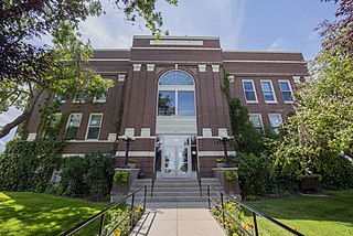
Meagher County is a county located in the U.S. state of Montana. As of the 2020 census, the population was 1,927. Its county seat is White Sulphur Springs.
Judith Basin County is a county in the U.S. state of Montana. As of the 2020 census, the population was 2,023. Its county seat is the town of Stanford.

Broadwater County is a county in the U.S. state of Montana. As of the 2020 census, the population was 6,774. Its county seat is Townsend. The county was named for Charles Arthur Broadwater, a noted Montana railroad, real estate, and banking magnate.

Chinook is a city in and the county seat of Blaine County, Montana, United States. The population was 1,185 at the 2020 census. Points of interest are the Bear Paw Battlefield Museum located in the small town's center and the Bear Paw Battlefield, located 20 miles (32 km) south of Chinook.

Harlem is a city in Blaine County, Montana, United States. The population was 769 at the 2020 census.

Townsend is a city in and the county seat of Broadwater County, Montana, United States. The population was 1,787 at the 2020 census.

East Helena is a city in Lewis and Clark County, Montana, United States, approximately 5 miles (8 km) east of downtown Helena. The population was 1,944 at the 2020 census. It is part of the Helena Micropolitan Statistical Area, which includes all of Lewis and Clark and Jefferson counties; its population is 83,058 according to the 2020 Census.

Chester is a town in and the county seat of Liberty County, Montana, United States. The population was 847 at the time of both the 2010 and 2020 U.S. Census.

Hot Springs is a town on the Flathead Indian Reservation in Sanders County, Montana, United States. The population was 557 at the 2020 census.

Thompson Falls is a city in and the county seat of Sanders County, Montana. The population was 1,336 at the time of the 2020 census.
Choteau is a city in and the county seat of Teton County, Montana, United States. The population was 1,721 at the 2020 census.
Ronan is a city in Lake County, Montana, United States. It is on the Flathead Indian Reservation. The population was 1,955 at the 2020 census.

Sulphur is a city in and county seat of Murray County, Oklahoma, United States. The population was 5,065 at the 2020 census, a 2.8 percent gain over the figure of 4,929 in 2010. The area around Sulphur has been noted for its mineral springs, since well before the city was founded late in the 19th century. The city received its name from the presence of sulfur in the water.

Spring City is a town in Rhea County, Tennessee, United States. The population was 1,949 at the 2020 census and 1,981 at the 2010 census. The town is located along Watts Bar Lake, and Watts Bar Dam and the Watts Bar Nuclear Generating Station are nearby.

Sulphur Springs is a city in and the county seat of Hopkins County, Texas, United States. As of the 2020 census, its population was 15,941. Sulphur Springs is located along the western edge of Northeast Texas.

White Sulphur Springs is a city in Greenbrier County in southeastern West Virginia, United States. The population was 2,231 at the 2020 census. The city emblem consists of five dandelion flowers and the citizens celebrate spring with an annual Dandelion Festival.


