Kewstoke

Last updated

Kewstoke
Woodspringpriory.jpg
Woodspring Priory
Somerset UK location map.svg
Red pog.svg
Kewstoke
Location within Somerset
Population1,690  [1]
OS grid reference ST341661
Unitary authority
Ceremonial county
Region
Country England
Sovereign state United Kingdom
Post town Weston-super-Mare
Postcode district BS22
Dialling code 01934
Police Avon and Somerset
Fire Avon
Ambulance South Western
UK Parliament
List of places
UK
England
Somerset
51°22′04″N2°57′37″W / 51.3677°N 2.9604°W / 51.3677; -2.9604 Coordinates: 51°22′04″N2°57′37″W / 51.3677°N 2.9604°W / 51.3677; -2.9604

Kewstoke is a civil parish and village in Somerset, England, within the unitary authority of North Somerset, located next to the strip of coast called Sand Bay. Its population in the 2011 census was 1,690. [1]

Contents

History

The parish was part of the Winterstoke Hundred. [2]

Governance

The parish council has responsibility for local issues, including setting an annual precept (local rate) to cover the council’s operating costs and producing annual accounts for public scrutiny. The parish council evaluates local planning applications and works with the local police, district council officers, and neighbourhood watch groups on matters of crime, security, and traffic. The parish council's role also includes initiating projects for the maintenance and repair of parish facilities, such as the village hall or community centre, playing fields and playgrounds, as well as consulting with the district council on the maintenance, repair, and improvement of highways, drainage, footpaths, public transport, and street cleaning. Conservation matters (including trees and listed buildings) and environmental issues are also of interest to the council.

The parish falls within the unitary authority of North Somerset which was created in 1996, as established by the Local Government Act 1992. Between 1 April 1974 and 1 April 1996, it was in the Woodspring district of the county of Avon. [3] Prior to 1974 the parish was part of the Axbridge Rural District. [4]

An electoral ward with the same name exists. The ward starts at Kewstoke on the Bristol Channel then moves inland to Puxton. The total ward population taken at the 2011 census was 3,380. [5]

The parish is represented in the House of Commons of the Parliament of the United Kingdom as part of the Weston-super-Mare county constituency. It was also part of the South West England constituency of the European Parliament prior to Britain leaving the European Union in January 2020.

Geography

Being in places only 6 metres above sea level, the settlements of Kewstoke and Sand Bay are, and have been historically, susceptible to flooding. Following several incidents of flooding [6] a sea defence of combined dune system (sand was imported from the estuary to form this) and concrete walls are now in place along much of Beach Road. Whilst the sea defences have proved very effective for the last two decades, concerns about the long-term stability of the dunes, in particular, remain.

In the Severn Estuary Shoreline Management Plan, 2000, commissioned by the Severn Estuary Coastal Group and carried out by Gifford Associated Consultants, the importance of sea defence maintenance was highlighted. The report stated that leaving the defences unmaintained would increase the risk of a severe flood to the low-lying residential area of Kewstoke and an extensive area of agricultural land that are currently defended. The authors went on to discuss the importance in the shorter and longer term of ensuring that the current defence line is kept and said that monitoring and research of the coastal processes on the foreshore is recommended. The Sand Bay Management Committee is keeping a close eye on the conditions of both the salt marsh and the sand dunes.

Landmarks

Monk's Steps (also known as St Kew's Steps) are an ancient set of stone steps leading from St Paul's church up through the woods on Monk's Hill. Although the origins of the steps are unknown, the presence of man in the adjacent woodland on Worlebury Hill can be traced back to the Iron Age.

Sport

There is a local football team, Kewstoke JFC.

The local primary school is Kewstoke Primary school, for children aged 4–11; it also has a preschool within the school for children aged 3-4. There used to be a pre-school at the village hall but it stopped because of a lack of children.

Religious sites

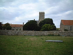
The local parish church, St Paul's, dates from the 12th century with the tower being built in 1395. The tower is in two stages, with rendered, diagonal buttresses with setbacks which rise through parapet as corner pinnacles. A polygonal stair turret at the south east corner rises to a pyramidal cap. The first stage has two 2-light perpendicular west window under a plain drip mould, and similar but smaller window with carved stops to the south. The second stage has one 2-light perpendicular window under a drip mould with carved stops on each side; all louvres except the west which is blank. A quatrefoil pierced parapet has gargoyles at the corner. It has been designated as a Grade I listed building. [7] In 1849 a reliquary was found in St Paul's Church that was believed to have come originally from the priory and to contain the blood of Thomas Becket. It is believed that it was moved to St Paul's for safe keeping at the time of the Dissolution of the Monasteries.

Near the village, at the base of a promontory called Middle Hope (which extends out into the sea as Sand Point), is Woodspring Priory, which is Grade I listed. [8] The priory was founded in 1210 by William de Courtenay, grandson of Reginald Fitz Urse (one of the knights who murdered Thomas Becket), perhaps to atone for the past action of his grandfather.

Related Research Articles

North Somerset Non-metropolitan district in England

North Somerset is a unitary district in Somerset, South West England. Whilst its area covers part of the ceremonial county of Somerset, it is administered independently of the non-metropolitan county. Its administrative headquarters is in the town hall in Weston-super-Mare.

Weston-super-Mare (UK Parliament constituency)

Weston-super-Mare is a constituency represented in the House of Commons of the UK Parliament since 2005 by John Penrose, a Conservative.

Woodspring Priory Grade I listed priory in North Somerset, United Kingdom

Woodspring Priory is a former Augustinian priory. It is near the scenic limestone promontory of Sand Point and Middle Hope, owned by the National Trust, beside the Severn Estuary about 3 miles (5 km) north-east of Weston-super-Mare, within the English unitary authority of North Somerset. Many of the buildings are Grade I listed, and the whole site is scheduled as an ancient monument.

Winscombe Human settlement in England

Winscombe is a large village in the North Somerset unitary district of Somerset, South West England, close to the settlements of Axbridge and Cheddar, on the western edge of the Mendip Hills, 7 miles (11 km) southeast of Weston-super-Mare and 14 miles (23 km) southwest of Bristol. The Parish of Winscombe and Sandford, centred on the Parish Church of Church of St James the Great, includes the villages/hamlets of Barton, Hale, Oakridge, Nye, Sidcot and Woodborough.

Kingston Seymour Human settlement in England

Kingston Seymour is a small village and civil parish with royal status in Somerset, England. It is situated within the unitary authority of North Somerset, between Clevedon and Weston-super-Mare on the North Somerset Levels. The parish has a population of 388.

Clapton in Gordano Human settlement in England

Clapton in Gordano is a village and civil parish in Somerset, England. It is situated within the unitary authority of North Somerset on the southern side of the Gordano Valley, immediately adjacent to the M5 motorway. The parish has a population of 348. There is a village football club, Clapton in Gordano FC. They currently run two sides with a view to continue progressing throughout the leagues. Their home ground is currently Clapton Lane, Portishead.

Bleadon Human settlement in England

Bleadon is a village and civil parish in Somerset, England. It is about 4 miles (6.4 km) south of Weston-super-Mare and, according to the 2011 census, has a population of 1,079.

Axbridge was a rural district in Somerset, England, from 1894 to 1974. It was named after the town of Axbridge.

Worle is a large village in North Somerset which is joined to the seaside town of Weston-super-Mare on its western edge. It, however, maintains a very separate identity, and may now be bigger than its more famous neighbour. Worle pre-dates Weston and was mentioned in the Domesday Book of 1086. In the book, it is said that Worle was owned by Walter of Douai, and consisted of 750 acres (3.0 km2) and valued at 6.5 hides. "Walter of Douai holds of the King, Worle. Edgar held it in the time of King Edward, and gelded for six hides and a half." The parish church of St Martin's sits on the side of Worlebury Hill and overlooks the village.

Locking, Somerset Human settlement in England

Locking is a village and civil parish in Somerset, England. It is a predominantly quiet residential area of North Somerset, 3.5 miles (5.6 km) south east of the town of Weston-super-Mare.

Burrington, Somerset Human settlement in England

Burrington is a small village and civil parish in Somerset, England. It is situated in the unitary authority of North Somerset, 5 miles (8.0 km) north east of Axbridge and about 10 miles (16 km) east of Weston-super-Mare. The parish includes the hamlets of Bourne and Rickford and has a population of 464.

Butcombe Human settlement in England

Butcombe is a village and civil parish in Somerset, England. The village is situated just north of Blagdon Lake, in North Somerset. The parish has a population of 218 and mainly consists of family-owned farmland. It no longer has any amenities apart from a telephone kiosk and a letter box.

Hutton, Somerset Human settlement in England

Hutton is a village and civil parish in Somerset, England. The parish, which has a population of 2,582, is within the unitary authority of North Somerset and located on the western edge of the Mendip Hills, close to Weston-super-Mare.

Loxton, Somerset Human settlement in England

Loxton is a village and civil parish in Somerset, England. It is close to the M5 motorway in the unitary authority of North Somerset. The parish includes the village of Christon and has a population of 192.

Puxton Village in Somerset, England

Puxton is a village and civil parish, 5 miles (8.0 km) north west of Axbridge in the unitary authority of North Somerset within the ceremonial county of Somerset, England.

Wick St. Lawrence Human settlement in England

Wick St. Lawrence is a civil parish and village in Somerset, England. It falls within the unitary authority of North Somerset. The population of the parish, which includes Bourton, Icelton and Ebdon, in the 2011 census was 1,331.

St. Georges, North Somerset Human settlement in England

St. Georges is a civil parish and village in the unitary authority of North Somerset, England. Its population in the 2011 census was 3,379.

Banwell Human settlement in England

Banwell is a village and civil parish on the River Banwell in the North Somerset district of Somerset, England. Its population was 2,919 according to the 2011 census.

St Pauls Church, Kewstoke Church in Somerset, England

The Church of St Paul in Kewstoke, Somerset, England dates from the 12th century with the tower being built in 1395. It has been designated as a Grade I listed building.

Sand Point and Middle Hope Headland in Somerset, England

Sand Point in Somerset, England, is the peninsula stretching out from Middle Hope, an 84.1-hectare (208-acre) biological and geological Site of Special Scientific Interest. It lies to the north of the village of Kewstoke, and the stretch of coastline called Sand Bay north of the town of Weston-super-Mare. On a clear day it commands views over Flat Holm, of the Bristol Channel, South Wales, Clevedon, the Second Severn Crossing and the Severn Bridge. A line drawn between Sand Point and Lavernock Point in South Wales marks the lower limit of the Severn Estuary and the start of the Bristol Channel.

References

  1. 1 2 "2011 Census Profile". North Somerset Council. Archived from the original (Excel) on 4 January 2014. Retrieved 4 January 2014.
  2. "Somerset Hundreds". GENUKI. Retrieved 9 September 2011.
  3. "The Avon (Structural Change) Order 1995". HMSO. Archived from the original on 30 January 2008. Retrieved 9 December 2007.
  4. "Axbridge RD". A vision of Britain Through Time. University of Portsmouth. Retrieved 4 January 2014.
  5. "Ward population 2011" . Retrieved 9 March 2015.
  6. "Severn Estuary Shoreline Management Plan — Non Technical Summary" (PDF). Severn Estuary Coastal Group. Archived from the original (PDF) on 18 May 2008. Retrieved 3 July 2008.
  7. "Parish Church of St. Paul". historicengland.org.uk. Retrieved 3 March 2007.
  8. "Priory Church (formerly listed as Woodspring Priory) (former Church of The Holy Trinity, St Mary and Thomas a Becket)". historicengland.org.uk. Retrieved 3 March 2007.