A microclimate is a local set of atmospheric conditions that differ from those in the surrounding areas, often slightly but sometimes substantially. The term may refer to areas as small as a few square meters or smaller or as large as many square kilometers. Because climate is statistical, which implies spatial and temporal variation of the mean values of the describing parameters, microclimates are identified as statistically distinct conditions which occur and/or persist within a region. Microclimates can be found in most places but are most pronounced in topographically dynamic zones such as mountainous areas, islands, and coastal areas.

The United Kingdom straddles the higher mid-latitudes between 49° and 61°N on the western seaboard of Europe. Since the UK is always in or close to the path of the polar front jet stream, frequent changes in pressure and unsettled weather are typical. Many types of weather can be experienced in a single day.

Pemba Island is a Tanzanian island forming part of the Zanzibar Archipelago, lying within the Swahili Coast in the Indian Ocean.
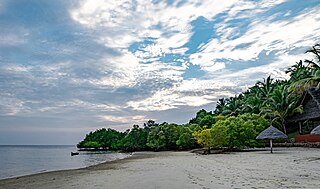
Mafia Island or Chole Shamba is an island of The Mafia Archipelago located in Mafia District in the southern Pwani Region of Tanzania across the Mafia Channel. The island is the third largest in Tanzanian ocean territory, but is not administratively included within the semi-autonomous region of Zanzibar, which has been politically separate since 1890. Mafia Island forms the largest part of Mafia District, one of the six administrative districts in the Pwani Region. As the Mafia Archipelago's main island, it's sometimes called Chole Shamba, meaning Chole farmlands in Swahili. This is in opposition to the historic settlement of Chole Mjini on Chole Island inside Mafia Bay. The island's population is over 65,000. The economy is based on fishing, subsistence agriculture and the market in Kilindoni. The island attracts some tourists, mainly scuba divers, birdwatchers, game fishermen, and people seeking relaxation.
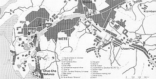
Wete is a town located on the Tanzanian island of Pemba. It is the capital of Pemba North Region, as well as the administrative seat for Wete District. It lies on the west side of the north part of the island. The town has a population of 35,951.

Mkoani is a town located on the Tanzanian island of Pemba. It is the capital of Pemba South region, as well as Mkoani District. Currently, Mkoani has the busiest harbour on Pemba island, most ferries from Zanzibar or the mainland arrive at Mkoani. The town has a population of 23,719

The climate of Puerto Rico in the Köppen climate classification is predominantly tropical rainforest. Temperatures throughout the year are warm to hot, averaging near 85 °F (29 °C) in lower elevations and 70 °F (21 °C) in the mountains. Easterly trade winds pass across the island year round while the rainy season stretches from April into November. The relatively cool trade winds are blocked by the mountains of the Cordillera Central which causes rain shadows and sharp variations in the temperature and wind speed over short distances. About a quarter of the average annual rainfall for Puerto Rico occurs during tropical cyclones, which are more frequent during La Niña years.

Zanzibar City or Mjini District, often simply referred to as Zanzibar is one of two administrative districts of Mjini Magharibi Region in Tanzania. The district covers an area of 15.4 km2 (5.9 sq mi). The district is comparable in size to the land area of Nauru. The district has a water border to the west by the Indian Ocean. The district is bordered to the east by Magharibi District. The district seat is in Stonetown. The city is the largest on the island of Zanzibar. It is located on the west coast of Unguja, the main island of the Zanzibar Archipelago, north of the much larger city of Dar es Salaam across the Zanzibar Channel. The city also serves as the capital of the Zanzibar Urban/West Region. In 2022 its population was 219,007.

The climate of the United States varies due to changes in latitude, and a range of geographic features, including mountains and deserts. Generally, on the mainland, the climate of the U.S. becomes warmer the further south one travels, and drier the further west, until one reaches the West Coast.

North Carolina's climate is varying, from the Atlantic coast in the east to the Appalachian Mountain range in the west. The mountains often act as a "shield", blocking low temperatures and storms from the Midwest from entering the Piedmont and Coastal Plain of North Carolina.

The climate of Ireland is mild, humid and changeable with abundant rainfall and a lack of temperature extremes. Ireland's climate is defined as a temperate oceanic climate, or Cfb on the Köppen climate classification system, a classification it shares with most of northwest Europe. The island receives generally warm summers and cool winters.
The climate of Indonesia is almost entirely tropical. The uniformly warm waters that make up 81% of Indonesia's area ensure that temperatures on land remain fairly constant, with the coastal plains averaging 28 °C (82 °F), the inland and mountain areas averaging 26 °C (79 °F), and the higher mountain regions, 23 °C (73 °F). Temperature varies little from season to season, and Indonesia experiences relatively little change in the length of daylight hours from one season to the next; the difference between the longest day and the shortest day of the year is only forty-eight minutes. This allows crops to be grown all year round.
Montreal is the second largest city in Canada and the largest city in the province of Quebec, located along the Saint Lawrence River at its junction with the Ottawa River. The city is geographically constrained, with the majority on the Island of Montreal in the Hochelaga Archipelago, and has several prominent features, including the eponymous Mount Royal. The region experiences four distinct seasons and is classified as a humid continental climate, with very cold and snowy winters and warm and humid summers.
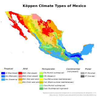
The climate of Mexico is very diverse. The Tropic of Cancer effectively divides the country into temperate and tropical zones. Land that is north of the twenty-fourth parallel experiences lower temperatures during the winter months. South of the twenty-fourth parallel, temperatures are fairly consistent all year round and vary solely as a function of elevation. The north of the country usually receives less precipitation than the south.
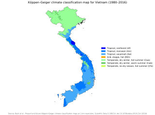
Vietnam has a monsoon-influenced climate typical of that of mainland Southeast Asia. The diverse topography, long latitude, and influences from the South China Sea lead to climatic conditions varying significantly between regions. The northern region experiences a monsoonal and temperate climate (Cfa) with four distinct seasons with winters typically dry and summers ranging from hot to mild. In southern and central areas, the climate is tropical monsoon (Aw) with only two seasons. In addition, a temperate climate exists in mountainous areas, which are found in Sa Pa and Da Lat, while a more continental climate exists in Lai Châu Province and Sơn La Province.

A humid subtropical climate is a temperate climate type characterized by hot and humid summers, and cool to mild winters. These climates normally lie on the southeast side of all continents, generally between latitudes 25° and 40° and are located poleward from adjacent tropical climates, and equatorward from either humid continental or oceanic climates. It is also known as warm temperate climate in some climate classifications.

The climate of the Falkland Islands is cool and temperate, regulated by the large oceans which surround it. The Falkland Islands are a British Overseas Territory located over 480 kilometres (298 mi) from South America, to the north of the Antarctic convergence, where cooler waters from the south mix with warmer waters from the north.

Cyprus has a subtropical climate - Mediterranean and semi-arid type - Csa and BShaccording to Köppen climate classification, with very mild winters on sea level and warm to hot summers. Snow is possible only in the Troodos mountains in the central part of the island. Rain occurs mainly in winter, with summer being generally dry.

Mafia District Council is one of eight administrative districts of Pwani Region in Tanzania. It administers not only the main Mafia Island but the entire Mafia Archipelago. The District covers an area of 642.6 km2 (248.1 sq mi). The Sea of Zanj completely encircles the District. Rufiji District is located on the other side of the Mafia Channel to the west. The district is comparable in size to the land area of Saint Lucia. The town of Kilindoni serves as its administrative capital. The District is home to the largest concentration of Whale Sharks in Africa, Mafia Island Marine Park, Historic Chole Island Ruins, Kisimani Mafia and Kua Ruins; and Mlola Forest Reserve. According to the 2012 Tanzania National Census, the population of the District was 46,438.

The climate of Seattle is temperate, classified in the warm-summer (in contrast to hot-summer) subtype of the Mediterranean zone by the most common climate classification although some sources put the city in the oceanic zone. It has cool, wet winters and warm, dry summers, covering characteristics of both. The climate is sometimes characterized as a "modified Mediterranean" climate because it is cooler and wetter than a "true" Mediterranean climate, but shares the characteristic dry summer and the associated reliance upon cooler-season precipitation. The city is part of USDA hardiness zone 9a, with surrounding pockets falling under 8b.

