Killarney is a municipality located on the northern shore of Georgian Bay in the Sudbury District of Ontario, Canada. Killarney is commonly associated with Killarney Provincial Park, which is a large wilderness park located to the east of the townsite which occupies much of the municipality's expanded boundary. In addition to the community of Killarney itself, the communities of Hartley Bay and Bigwood, and the ghost towns of French River, Collins Inlet and Key Harbour, are also located within the municipal boundaries. The eastern end of the La Cloche Mountain Range is also located within the municipality of Killarney.
Killarney's established community was founded in 1820 by Étienne De La Morandière (although indigenous peoples were living there prior), a French Canadian originally from Varennes, Quebec and a fur trader in Sault Ste Marie, Michigan, along with his wife Josette Sai Sai Go No Kwe, an indigenous woman from Michigan and a close relative of Chief Kitchi, meaning Big Gun. Soon after the arrival of the De La Morandières, many French-Canadian families started to settle in Killarney, starting many fishing businesses in the process. Although there was already an existing settlement here at that time, they are credited with the founding of the settlement.
The population increased when the logging industry took off in Colins Inlet in the late 1800s. Hundreds of people from around Ontario went to Colins Inlet for work and established a large community in the area. The logging industry collapsed in the early 1900s because of the low demand and the population declined. Remains of the large village can be seen across from the present-day Mill Lake lodge.
Another key industry that had a major impact on Killarney's economy was the fishing industry. There were many fishing companies in Killarney including C.W.L (Charles William Low), The Nobles, Charles Low/Joseph Roque partnership, and Albert Lowe. The collapse of the fishing industry at the end of the 1950s affected many families in Killarney including the Low, Roque, Jackman, Proulx, and Herbert families. Recreational fishing was also an industry. A fishing camp was run by the Fruehauf Trailer Company out of Detroit, Michigan. Roy Fruehauf, president of the company from 1949 to 1961, was primarily responsible for operating Killarney Mountain Lodge. Clients and guests would be flown in via Mallard sea planes for vacations during the warmer summer months.
A quarry in Killarney Bay had fixed this issue for many families by creating more employment opportunities in the area. The quarry is located on the westside of the Landsdowne channel and had been very financially efficient after the downfall of the fishing industry.The quarry eventually was shut down in 2016 over a labour dispute and the industry that replaced it was tourism.
The major tourism businesses in Killarney were the Killarney mountain lodge, the Sportsmans Inn, the Killarney Bay Inn, the Pines Inn, Herbert fisheries, and Pitfield's General Store. The booming tourism industry brought hundreds of thousands of dollars to the businesses of Killarney as well as the many families that contributed to it. The current tourism businesses of Killarney include the Killarney Mountain Lodge, the Sportsmans Inn, Gateway Marina, Herbert fisheries, and Pitfield's General Store.
When and why the place name Shebahonaning was changed to Killarney is unknown. Lady Dufferin, wife of the Governor-General of Canada, has often been credited with the name change, but the passage in her journal which describes their stop in Killarney is dated 1874—almost twenty years after the Post Office had replaced the Shebahonaning postal stamp with one reading Killarney.
In July 1962, Highway 637 was established, connecting Killarney to major highways like Highway 69 and Highway 17, making it easier for people to travel to major cities like Toronto or Sudbury. Before that, the people of the town had to either go by boat in the summer to Little Current and then take a train to Sudbury or other areas to obtain food and resources or by horse and buggy in the winter.
The current municipality was incorporated on January 1, 1999, when the Ontario provincial government expanded the boundaries of the township of Rutherford and George Island, the former governing body of the community of Killarney. The municipality was also transferred from the Manitoulin District to the Sudbury District at that time. In 2006, the municipality was enlarged again when it annexed the unorganized mainland portion of Manitoulin District.[2]
Economy
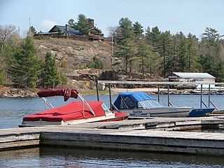
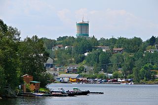
The Killarney Channel from the view of Gateway Marina
The Killarney area economy is based primarily on tourism consisting mainly of wilderness lodges campgrounds and Retail Services geared towards campers and other visitors to Killarney Provincial Park and Killarney Outfitters is located just outside of the town is the primary place where folks go to prepare for Backcountry camping all ones camping needs can be found here as well as delicious London ice cream.
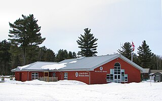
A community Museum the Killarney Centennial museum is located in Killarney across the municipal offices. One tourism website listed 21 things to do in the area although much of the contest related to provincial parks.
The Killarney Outfitters offers canoe, kayak, and paddle board rentals, along with renting out all of the gear required for a fantastic camping trip. The Outfitters also provides campers with a complete outfitting, supplying them with delicious well-balanced meals and all the equipment need, including tents, sleeping pads, sleeping bags, stoves, mess kits, and so much more! Inside the store you can find last minute camping needs such as a stove, sleeping bag, kitchen supplies, as well as high quality Vasque and Solomon hiking shoes. The store also gives tourists an opportunity to buy souvenirs of their trip to Killarney like sweaters, T-shirts, maps, and so much more. Killarney Outfitters typically has a celebration of summer sale where many of their products are 20% off, for example this year the store has all of its Vasque, Marmot, and MSR products 20% off. Killarney Outfitters also provides EV charging, A full charge costs $40 and by the hour it is $7.50. Killarney Outfitters also has over forty years of experience steering visitors to the most desirable and sought-after canoe, kayak, and hiking routes and trails within Killarney Provincial Park and Georgian Bay.
There are also three campgrounds in Killarney, Killarney Provincial Park, Roche Rouge campground, and Roque's Marina. Roque's Marina amenities include camping with 15 or 30 amp power, EV Charge, transient and seasonal dockage, 24hr coin operated laundromat, showers, and indoor toilets, along with block and cube ice.
There are two places to stay overnight in Killarney the Killarney Mountain Lodge and the Sportsman's inn which are sister resorts. Guests from either one can use the amenities of both.
Although not officially part of the Sudbury east region, Killarney participates in the regional Sudbury East planning board with the municipalities of French River St Charles and Mark stay Warren.
During the Spring and Summer of 2020 the area's tourism suffered because of the COVID-19 pandemic in Canada and around the world the restrictions on travel to Canada from other countries including the US severely affected the economy of Killarney.
The current tourism businesses of Killarney include the Killarney Mountain lodge, the Sportsman's inn, Gateway Restaurant & Marina, Herbert fisheries, Killarney Outfitters, Roque's Marina and Pittsfield General store. Both the Killarney Mountain Lodge and the Sportsman's Inn we're at 1 point owned and operated by members of the East family who had spearheaded the tourism industry in the town since the 1960s. Although in 2015 the family sold the Killarney Mountain Lodge to Holden Rhodes a lawyer from London. A few years later Rhodes bought the Sportsman's in as well as the Killarney Bay Inn although he used the Killarney Bay Inn for staff housing instead of hospitality. Throughout Holden Rhodes ownership of the Killarney Mountain Lodge and Sportsman's Inn and the Killarney Bay Inn he renovated and rejuvenated the properties in many ways and help the marketing of the town which increased its tourism and contributed to its economy. Holden Rhodes also merged the Killarney mountain lodge and the Sportsman's Inn into two sister properties which allowed guests to use the amenities of both resorts.
Geography
The larger municipality of Killarney now encompasses virtually all of Killarney Provincial Park and the French River delta, and in fact extends all the way to Highway 69, over 70 kilometres from the townsite. Despite the municipality's geographic size, most of its population continues to reside in the community of Killarney itself, although smaller settlements also exist at Hartley Bay and Bigwood.
Fishing industry
There were many fishing companies in Killarney including C.W.L. (Charles William Low), the Nobles, Charles Low Joseph Roque partnership, and Albert Lowe most of these people at some point work together in Killarney to sustain the fishing needs of the community. The main difference between the many different fishing businesses in Killarney was how they fished. Many fishing families and businesses in town built fishing outposts in the area of Georgian Bay surrounding the village of Killarney. The collapse of the fishing industry at the end of the 1950s affected many families in Killarney including the low, Roques, Jackman, Proulx, and Herbert families. The collapse caused many families of Killarney to either go broke or have to look into other means of employment in order to support their families.
The Mayor of Killarney is Michael Reider, and the councillors are Ward 1: Rob Campbell, Dave Froats, and Peggy Roque Ward 2: Mary Bradbury and Nicola Grubic.[4]
In the 2021 Census of Population conducted by Statistics Canada, Killarney had a population of 397 living in 193 of its 443 total private dwellings, a change of 2.8% from its 2016 population of 386. With a land area of 1,469.4km2 (567.3sqmi), it had a population density of 0.3/km2 (0.7/sqmi) in 2021.[5]
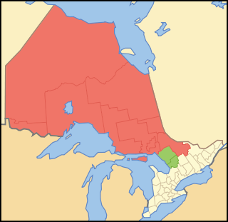
Northern Ontario is a primary geographic and quasi-administrative region of the Canadian province of Ontario, the other primary region being Southern Ontario. Most of the core geographic region is located on part of the Superior Geological Province of the Canadian Shield, a vast rocky plateau located mainly north of Lake Huron, the French River, Lake Nipissing, and the Mattawa River. The statistical region extends south of the Mattawa River to include all of the District of Nipissing. The southern section of this district lies on part of the Grenville Geological Province of the Shield which occupies the transitional area between Northern and Southern Ontario. The extended federal and provincial quasi-administrative regions of Northern Ontario have their own boundaries even further south in the transitional area that vary according to their respective government policies and requirements. Ontario government departments and agencies such as the Growth Plan for Northern Ontario and the Northern Ontario Heritage Fund Corporation define Northern Ontario as all areas north of, and including, the districts of Parry Sound and Nipissing for political purposes, and the federal but not the provincial government also includes the district of Muskoka.
Midland is a town located on Georgian Bay in Simcoe County, Ontario, Canada. It is part of the Huronia/Wendat region of Central Ontario.
Sudbury, officially the City of Greater Sudbury, is the largest city in Northern Ontario by population, with a population of 166,004 at the 2021 Canadian Census. By land area, it is the largest in Ontario and the fifth largest in Canada. It is administratively a single-tier municipality and thus is not part of any district, county, or regional municipality. The City of Greater Sudbury is separate from, but entirely surrounded by the Sudbury District. The city is also referred to as "Ville du Grand Sudbury" among Francophones.
Lake of Bays is a township municipality within the District Municipality of Muskoka, Ontario, Canada. The township, situated 193 kilometres (120 mi) north of Toronto, is named after the Lake of Bays. During the 2016 census, the township had a population of 3,167 and encompassed 677.91 square kilometres (261.74 sq mi) of land.
The Sudbury District is a district in Northeastern Ontario in the Canadian province of Ontario. It was created in 1894 from townships of eastern Algoma District and west Nipissing District.
Carling is a township in Ontario, Canada, located in the District of Parry Sound on Georgian Bay. Killbear Provincial Park is located in the municipality.
Manitoulin District is a district in Northeastern Ontario within the Canadian province of Ontario. It was created in 1888 from part of the Algoma District. The district seat is in Gore Bay.
Sioux Lookout is a town in Northwestern Ontario, Canada. Located approximately 350 km (220 mi) northwest of Thunder Bay, it has a population of 5,272 people, an elevation of 390 m (1,280 ft), and its boundaries cover an area of 536 km2 (207 sq mi), of which 157 km2 (61 sq mi) is lake and wetlands. Known locally as the "Hub of the North", it is serviced by the Sioux Lookout Airport, Highway 72, and the Sioux Lookout railway station. According to a 2011 study commissioned by the municipality, health care and social services ranked as the largest sources of employment, followed by the retail trade, public administration, transportation and warehousing, manufacturing, accommodation and food services, and education.
French River, also known as Rivière-des-Français, is a municipality in the Canadian province of Ontario, in the Sudbury District. The municipality had a population of 2,662 in the Canada 2016 Census. It was formed in 1999 through the merger of the Township of Cosby, Mason and Martland and surrounding unincorporated portions of the Unorganized North Sudbury District. It was named after the French River, which flows through the municipality.
Mattawa is a town in northeastern Ontario, Canada at the confluence of the Mattawa and Ottawa Rivers in Nipissing District. The first Europeans to pass through this area were Étienne Brûlé and Samuel de Champlain.
Chapleau is a township in Sudbury District, Ontario, Canada. It is home to one of the world's largest wildlife preserves. Chapleau has a population of 1,942 according to the 2016 Canadian census.
Killarney is an unincorporated community in southwestern Manitoba, Canada, at the corner of Manitoba Provincial Trunk Highways 3 and 18.
Thessalon is a town in the Canadian province of Ontario, located at the junction of Highway 17 and Highway 129 on the north shore of Lake Huron. It is surrounded by, but not part of, the municipality of Huron Shores, and is part of Algoma District. The main industries are timber and tourism. The town is a popular retirement community. It is the administrative headquarters of the Thessalon First Nation.
Red Lake is a municipality with town status in the Canadian province of Ontario, located 535 km (332 mi) northwest of Thunder Bay and less than 100 km (62 mi) from the Manitoba border. The municipality consists of six small communities—Balmertown, Cochenour, Madsen, McKenzie Island, Red Lake and Starratt-Olsen—and had a population of 4,107 people in the Canada 2016 Census.
Temagami, formerly spelled Timagami, is a municipality in northeastern Ontario, Canada, in the Nipissing District with Lake Temagami at its heart.
Redditt is an unincorporated community in Unorganized Kenora District in northwestern Ontario, Canada. It is on the MacFarlane River, and located at the northern terminus of Ontario Highway 658, 27 kilometres (17 mi) north of Kenora. Redditt is also the name of the surrounding geographic township that includes the community.
Jan Lake is a community on the south-eastern shore of Jan Lake on Doupe Bay in the north-eastern part of the Canadian province of Saskatchewan. The community has a Canadian Coast Guard wharf, provincial and private campgrounds, pubs, as well as many tourist lodges, which focus on fishing, camping, and private cabins. Access is from Highway 135 and Jan Lake Airport, which is located along Highway 135, near the intersection with Highway 106.
Rainbow Country is a local services board in the Canadian province of Ontario. It encompasses and provides services to the communities of Whitefish Falls and Willisville in the Unorganized North Sudbury District and Birch Island and McGregor Bay in the Manitoulin District.
The Rural Municipality of Moose Range No. 486 is a rural municipality (RM) in the Canadian province of Saskatchewan within Census Division No. 14 and SARM Division No. 4.
Killarney Mountain Lodge is a resort located on Georgian Bay in Killarney, Ontario. Killarney Mountain Lodge contains the Canada House Conference Centre, the largest log-built conference centre in the world. The name "Canada House" comes from the local techniques, where people and materials were brought together in the completion of this structure. Construction started in 2017 and the building was finished in 2019.
This page is based on this Wikipedia article Text is available under the CC BY-SA 4.0 license; additional terms may apply. Images, videos and audio are available under their respective licenses.