Kilmartin Glen

Last updated

View of Kilmartin from Dunadd Dunadd Fort - view.jpg
View of Kilmartin from Dunadd

Kilmartin Glen is an area in Argyll north of Knapdale. It has the most important concentration of Neolithic and Bronze Age remains in mainland Scotland. [1] The glen is located between Oban and Lochgilphead, [2] surrounding the village of Kilmartin. In the village, Kilmartin Museum [3] explains the stories of this ancient landscape and the people who dwelt there. There are more than 800 ancient monuments within a six-mile (ten-kilometre) radius of the village, with 150 monuments being prehistoric. Monuments include standing stones, a henge monument, numerous cists, and a "linear cemetery" comprising five burial cairns. Several of these, as well as many natural rocks, are decorated with cup and ring marks.

Contents

The remains at Dunadd of the fortress of the Scots, a royal centre of Dal Riata, are located to the south of the glen, on the edge of the Moine Mhòr ("Great Moss"). Kilmartin Museum is located within the village itself and inspires and educates people by interpreting, explaining and conserving the internationally important archaeological landscape, artefacts, and natural heritage of Kilmartin Glen. [3]

The linear cemetery

View south into Kilmartin Glen from Kilmartin village churchyard Kilmartin glen 2006.jpg
View south into Kilmartin Glen from Kilmartin village churchyard

The most visible feature of the Kilmartin Glen is the linear arrangement of cairns, running over three miles (five kilometres) south-by-southwest of the village. There are five remaining cairns in the alignment, although cropmarks and other traces suggest that there may originally have been more. The burial cairns are of Bronze Age origin, with the exception of Nether Largie South cairn, which is a Stone Age structure, rebuilt in the Bronze Age.

Glebe Cairn

The most northerly cairn, Glebe is situated immediately to the west of Kilmartin Village. The cairn was excavated in 1864 by the antiquary Canon William Greenwell, and two concentric stone circles were found beneath the stones. At the centre were two cist burials, and finds recovered included a jet necklace and a decorated bowl. [4]

Nether Largie North Cairn

Nether Largie Mid Cairn

This cairn was first excavated in 1929, shortly after much of the stone had been reused in roadbuilding. It is around 30m across, and was formerly 3m in height. Kerbstones, which formed the boundary of the cairn, can still be seen. Inside two cists were found, with grooved joints between the stone slabs. Cup marks, and a carving of an axehead, can be seen on the southern cist. [5] [6]

Nether Largie South Cairn

Nether Largie South is the oldest monument of the linear cemetery. It is a Neolithic chambered cairn of the Clyde type, probably dating from the fourth millennium BC. The cairn was probably originally around 40m in diameter and 4m high, although stone robbing has reduced its size. The internal chamber, subdivided into four by floor slabs, is over 6m long, around 1.7m high, and 1.8m wide at its northern end, tapering to 1.5m. Although now exposed, the chamber would have been encased within the cairn. Two cists were also located in this cairn, to the south of the chamber. Archaeological finds recovered from Nether Largie South include Neolithic pottery and arrowheads. [7] [8]

Ri Cruin Cairn

This is the most southerly cairn in the linear cemetery, believed locally to be the possible burial place of a King. It was built between 2200 BC and 1950 BC, and was more recently used as a lime kiln. Three excavations took place at the site: By Reverend Mapleton (1870); Craw (1929); and V. Gordon Childe (1936). All traces of the lime kiln were removed following a reconstruction of the site. [9]

Standing stones

Nether Largie, Kilmartin Glen Nether Largie.jpg
Nether Largie, Kilmartin Glen

Ballymeanoch

Temple Wood

Nether Largie standing stones

Nether Largie standing stones are located southeast of Temple Wood stone circle and are composed of four menhirs, arranged in pairs an approximately 70 metres apart, with a single menhir in the middle. Around which are seven smaller stones and one fallen one. Another menhir is one hundred metres to the northwest leading towards the circle. Alexander Thom toured this site with Magnus Magnusson in 1970 in a BBC television documentary called "Chronicle: Cracking the stone age code". He suggested that it "gave so much information that it must be regarded as one of the most important, if not the most important site in Britain". He clarified his hypothesis that it was a lunar observatory for predicting eclipses. A reassessment of this hypothesis was carried out by Jon Patrick from Melbourne University in 1979. His conclusion was:

that there are reasonable grounds for doubting that the Kilmartin Stones were deliberately orientated on the occurrence of any type of astronomical phenomena, for the following reasons:

(i) the Barbreck Stones do not indicate any of the same declinations of celestial bodies as the Kilmartin Stones;
(ii) the Barbreck Stones do not unambiguously indicate the declinations of any significant celestial body; and

(iii) the Barbreck Stones do not indicate any prominent notches that can be used for investigation into the orbital variations of the Moon. [10]

Cup and ring marks

Kilmartin Glen has "a remarkable concentration of some of the most impressive cup and ring decorated rock surfaces in Scotland". [11] The purpose, and even the precise date, of cup and ring marks is uncertain. They are found on natural rock surfaces at Achnabreck, [11] Cairnbaan, [12] Ballygowan, [13] and Baluachraig near Kilmichael Glassary. [14]

Carving depicting animals

In May 2021, archaeologists announced the discovery of prehistoric ancient deer carvings thought to date to the Neolithic or Early Bronze Age inside Dunchraigaig Cairn. They are the first of their kind to be found in Scotland. Depictions were contained two male red deer with full-grown forked horns, which were considered to have been the largest deer species in Scotland during this time. [15] [16] [17] [18]

Bruach An Druimein

Two kilometers south of Kilmartin and one kilometer south of the Nether Largie South Cairn is the site of Bruach An Druimein. Excavated in the 1960s in advance of gravel quarrying, archaeologists discovered the remains of a Bronze Age cists cemetery, the remains of two round houses from the Iron Age, the first certain Iron Age roundhouses to have been discovered by excavation in Argyll, and a standing stone of a fairly recent date, the 19th century. The archaeological materials were examined shortly after the excavation but has since been reexamined in the 2000s and that has led to different interpretations of the site. Stone tools that were originally thought to be from the Mesolithic period, ending 3000 BC, are now believed to be from the neolithic or Bronze Age, but not related to the cist burials. Two medieval glass beads were found that have similar chemical compositions to those found at Dunadd, leading the archaeologists to believe the site was associated with Dunadd. [19]

Use in cultural productions

In 2007, Kilmartin Glen was the setting for Half Life, a piece of landscape art and performance created by the Scottish theatre company NVA in collaboration with the National Theatre of Scotland. [20]

See also

Related Research Articles

<span class="mw-page-title-main">Chambered cairn</span> Burial monument (Usually Neolithic)

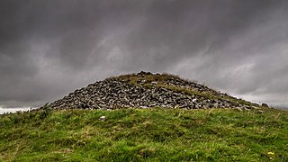
A chambered cairn is a burial monument, usually constructed during the Neolithic, consisting of a sizeable chamber around and over which a cairn of stones was constructed. Some chambered cairns are also passage-graves. They are found throughout Britain and Ireland, with the largest number in Scotland.

<span class="mw-page-title-main">Dunadd</span>

Dunadd is a hillfort in Argyll and Bute, Scotland, dating from the Iron Age and early medieval period and is believed to be the capital of the ancient kingdom of Dál Riata. Dal Riata was a Gaelic kingdom spanning the northern Irish coast to Argyll and the Scottish islands in the early centuries AD, possibly after the Romans had abandoned Southern Britain and at the time when the Anglo Saxons were crossing the North Sea to counter incursions over Hadrian's Wall by the Picts and Dalriadan Scots.

<span class="mw-page-title-main">Cowal</span> Human settlement in Scotland

Cowal is a rugged peninsula in Argyll and Bute, on the west coast of Scotland. It is bounded on the west by Loch Fyne and on the east by Loch Long and the Firth of Clyde. The Kyles of Bute separate it from the Isle of Bute to the south.

<span class="mw-page-title-main">Clava cairn</span> Type of Bronze Age chamber tomb

The Clava cairn is a type of Bronze Age circular chamber tomb cairn, named after the group of three cairns at Balnuaran of Clava, to the east of Inverness in Scotland. There are about 50 cairns of this type in an area round about Inverness. They fall into two sub-types, one typically consisting of a corbelled passage grave with a single burial chamber linked to the entrance by a short passage and covered with a cairn of stones, with the entrances oriented south west towards midwinter sunset. In the other sub-type an annular ring cairn encloses an apparently unroofed area with no formal means of access from the outside. In both sub-types a stone circle surrounds the whole tomb and a kerb often runs around the cairn. The heights of the standing stones vary in height so that the tallest fringe the entrance and the shortest are directly opposite it.

<span class="mw-page-title-main">Prehistoric Scotland</span> Prehistory of Scotland

Archaeology and geology continue to reveal the secrets of prehistoric Scotland, uncovering a complex past before the Romans brought Scotland into the scope of recorded history. Successive human cultures tended to be spread across Europe or further afield, but focusing on this particular geographical area sheds light on the origin of the widespread remains and monuments in Scotland, and on the background to the history of Scotland.

<span class="mw-page-title-main">Cup and ring mark</span> Form of prehistoric art

Cup and ring marks or cup marks are a form of prehistoric art found in the Atlantic seaboard of Europe (Ireland, Wales, Northern England, Scotland, France, Portugal, and Spain – and in Mediterranean Europe – Italy, Azerbaijan and Greece, as well as in Scandinavia and in Switzerland.

<span class="mw-page-title-main">Kilmartin</span> Village in Argyll and Bute, Scotland

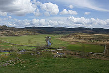
Kilmartin is a small village in Argyll and Bute, western Scotland. It is best known as the centre of Kilmartin Glen, an area with one of the richest concentrations of prehistoric monuments and historical sites in Scotland. It contains over 800 monuments within a six-mile (ten-kilometre) radius. It is home to Kilmartin Museum and the Kilmartin Hotel.

<span class="mw-page-title-main">Ford, Argyll</span> Human settlement in Scotland

Ford is a small village at the southern end of Loch Awe in Argyll, Scotland. The village originated as a stopping point on the drove route to Inveraray. The Ford Hotel dates back to 1864, and was probably erected on the site of the old change house. Today it is a guest house and is a listed building.

<span class="mw-page-title-main">Callanish IV</span>

The Callanish IV stone circle is one of many megalithic structures around the better-known Calanais I on the west coast of the Isle of Lewis, in the Outer Hebrides, Scotland. It is a scheduled monument and its official name is Sron a'Chail. The site was first surveyed and recorded by RCAHMS in 1914 and again in 2009, with another survey in the 1970s by other archaeologists, but no known archaeological excavations have taken place at the stones.

<span class="mw-page-title-main">Carn Liath (broch)</span>

Càrn Liath is an Iron Age broch on the eastern shore of the Scottish Highlands, near Golspie, Sutherland.

<span class="mw-page-title-main">Temple Wood</span>

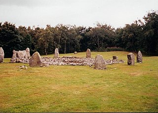
Temple Wood is an ancient site located in Kilmartin Glen, near Kintyre, Argyll, Scotland. The site includes two circles. The southern circle contains a ring of 13 standing stones about 12 metres in diameter. In the past it may have had 22 stones. In the centre is a burial cist surrounded by a circle of stones about 3 metres in diameter. Other later burials are associated with the circle. According to the Historic Scotland information marker at the site, the southern circle's first incarnation may have been constructed around 3000 BC.

<span class="mw-page-title-main">Garynahine</span> Human settlement in Scotland

Garynahine is a settlement on Lewis, in the Outer Hebrides, Scotland. Garynahine is situated at a T-junction where roads from Stornoway, Uig and the west side of Lewis all meet. The roads are the A858 and the B8011. Garynahine is within the parish of Uig.

<span class="mw-page-title-main">Rendall</span>

Rendall is a parish on Mainland, Orkney, Scotland. It is in the north west of the island and lies east of the parishes of Birsay and Evie and north east of Harray. The island of Gairsay is also in the parish.

Forteviot Bronze Age tomb is a Bronze Age burial chamber discovered in 2009 at Forteviot near Perth, Scotland. The Bronze Age tomb is one of a number of archaeological digs at the site that Co-directors of the excavation, Dr. Gordon Noble of the University of Aberdeen, and professor Stephen Driscoll and Dr Kenneth Brophy, both of the University of Glasgow, are currently conducting.

The Pettigarths Field Cairns is a Neolithic site in the parish of Nesting, northeastern Whalsay, in the Shetland islands of Scotland. It is located approximately 140 metres (460 ft) to the northwest of Benie Hoose. The site contains upright stones as well as masonry. The south cairn is roughly 6 metres (20 ft) square, with an eastern entrance passage and circular chamber about 2 metres across. 4 metres (13 ft) to the north is a round cairn, 4.5 metres (15 ft) in diameter, with a rectangular cist. The two cairns are located on a rise, about 140 metres (460 ft) northwest of Benie Hoose.

<span class="mw-page-title-main">Prehistoric art in Scotland</span> Overview and examples of prehistoric art in Scotland

Prehistoric art in Scotland is visual art created or found within the modern borders of Scotland, before the departure of the Romans from southern and central Britain in the early fifth century CE, which is usually seen as the beginning of the early historic or Medieval era. There is no clear definition of prehistoric art among scholars and objects that may involve creativity often lack a context that would allow them to be understood.

<span class="mw-page-title-main">Mid Gleniron</span> Historic site

Mid Gleniron is a prehistoric site in Dumfries and Galloway used in the Neolithic and Bronze Age. The site is a scheduled ancient monument that comprises a group of six burial cairns. Two of the cairns, Mid Gleniron I and Mid Gleniron II are chambered cairns of the Clyde tradition. These are of historic importance because of their multi-stage construction which provides evidence for the development of Clyde cairns at the beginning of the Neolithic period.

<span class="mw-page-title-main">Loanhead of Daviot stone circle</span> Recumbent stone circle in Aberdeenshire

Loanhead of Daviot stone circle is a recumbent stone circle in Aberdeenshire in lowland northeast Scotland. The circle consists of the recumbent stone with its flankers and a complete set of eight orthostats about 21 metres (69 ft) in diameter surrounding a low kerbed ring cairn which has an open court. However, the present appearance has in part been produced by substantial restoration after archaeological excavation in 1934, and in 1989 by the removal of the stones covering the central court.

<span class="mw-page-title-main">Balbirnie Stone Circle</span>

Balbirnie Stone Circle is an archaeological site, a stone circle on the north-eastern edge of Glenrothes, in Fife, Scotland. The site was in use from the late Neolithic period to the late second millennium BC.

References

  1. Dawson, Jane (1995). "Argyll:The Enduring Heartland" . Scottish Historical Review. 74 (1): 87. doi:10.3366/shr.1995.74.1.75. hdl: 20.500.11820/1ce6c0ef-90ec-4a98-9501-f3ece9cd5267 . Retrieved 27 December 2017.
  2. "Kilmartin". Gazetteer for Scotland. Retrieved 27 December 2017.
  3. 1 2 "Kilmartin Museum" . Retrieved 30 November 2017.
  4. Cowie, Trevor, "The Bronze Age: from Sacred Landscape to Warrior Society", in Omand, Donald (ed.) The Argyll Book, Birlinn, 2004
  5. "Nether Largie Mid Cairn". www.historicenvironment.scot. Retrieved 11 August 2021.
  6. "Nether Largie Mid | Canmore". canmore.org.uk. Retrieved 11 August 2021.
  7. "Nether Largie South Cairn". www.historicenvironment.scot. Retrieved 11 August 2021.
  8. "Nether Largie South | Canmore". canmore.org.uk. Retrieved 11 August 2021.
  9. Webb, S. (2012). In the Footsteps of Kings. KHT.
  10. Patrick, J., A Reassessment of the Lunar Observatory Hypothesis for the Kilmartin Stones, Journal of History of Astronomy, Archaeoastronomy Supplement, Vol. 10, p. 78-, 1979, SAO/NASA Astrophysics Data System (ADS)
  11. 1 2 Savile, Alan, "The Early peoples", in Omand, Donald (ed.) The Argyll Book, Birlinn, 2004
  12. "Cairnbaan Cup And Ring Marks". Kilmartin Glen. Historic Scotland. Retrieved 13 August 2014.
  13. "Ballygowan Cup And Ring Marks". Kilmartin Glen. Historic Scotland. Retrieved 13 August 2014.
  14. "Baluachraig Cup And Ring Marks". Kilmartin Glen. Historic Scotland. Retrieved 13 August 2014.
  15. "Prehistoric animal carvings discovered for the first time in Scotland". www.historicenvironment.scot. Historic Environment Scotland. Retrieved 1 September 2021.
  16. "Extremely rare prehistoric animal carvings found for first time in Scotland". BBC News. 31 May 2021. Retrieved 1 September 2021.
  17. "Prehistoric animal carvings discovered for the first time in Scotland". HeritageDaily - Archaeology News. 1 June 2021. Retrieved 1 September 2021.
  18. "Prehistoric animal carvings discovered for first time in Scotland". www.scotsman.com. Retrieved 1 September 2021.
  19. "Vol 27 (2008): Bruach An Druimein, Poltalloch, Argyll: excavations directed by the late Eric Cregeen, 1960-2 | Scottish Archaeological Internet Reports". journals.socantscot.org. Retrieved 11 August 2021.
  20. "Half Life – NVA". nva.org.uk. Nacionale Vita Activa. Archived from the original on 2 May 2021.

56°8′1″N5°29′13″W / 56.13361°N 5.48694°W / 56.13361; -5.48694