
The Republican River is a river in the central Great Plains of North America, rising in the High Plains of eastern Colorado and flowing east 453 miles (729 km) through the U.S. states of Nebraska and Kansas.

The Arkansas River is a major tributary of the Mississippi River. It generally flows to the east and southeast as it traverses the U.S. states of Colorado, Kansas, Oklahoma, and Arkansas. The river's source basin lies in Colorado, specifically the Arkansas River Valley. The headwaters derive from the snowpack in the Sawatch and Mosquito mountain ranges. It flows east into Kansas and finally through Oklahoma and Arkansas, where it meets the Mississippi River.

The Platte River is a major river in the State of Nebraska. It is about 310 mi (500 km) long; measured to its farthest source via its tributary, the North Platte River, it flows for over 1,050 miles (1,690 km). The Platte River is a tributary of the Missouri River, which itself is a tributary of the Mississippi River which flows to the Gulf of Mexico. The Platte over most of its length is a broad, shallow, meandering stream with a sandy bottom and many islands—a braided stream.

The Fryingpan River is a tributary of the Roaring Fork River, approximately 42 miles (68 km) long, in Eagle and Pitkin counties in Colorado, United States.

The Illinois River is a 145-mile-long (233 km) tributary of the Arkansas River in the U.S. states of Arkansas and Oklahoma. The Osage Indians named it Ne-eng-wah-kon-dah, which translates as "Medicine Stone River." The state of Oklahoma has designated its portion as a Scenic River. The Illinois River is a significant location in the 1961 Wilson Rawls novel, Where the Red Fern Grows.

The North Fork Cache la Poudre River is a tributary of the Cache la Poudre River, approximately 59.2 miles (95.3 km) long, in north central Colorado in the United States. It drains a mountainous area of north central Larimer County northwest of Fort Collins on the western side of the Laramie Foothills.
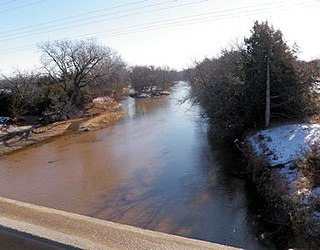
The Medicine Lodge River is a 130-mile-long (210 km) tributary of the Salt Fork of the Arkansas River in southern Kansas and northern Oklahoma in the United States. Via the Salt Fork and Arkansas rivers, it is part of the watershed of the Mississippi River.
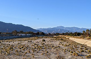
The Whitewater River is a small permanent stream in western Riverside County, California, with some upstream tributaries in southwestern San Bernardino County. The river's headwaters are in the San Bernardino Mountains, and it terminates at the Salton Sea in the Colorado Sonoran Desert. The area drained by the Whitewater River is part of the larger endorheic Salton Sea drainage basin.

Seneca Creek is a 19.6-mile-long (31.5 km) tributary of the North Fork of the South Branch of the Potomac River located entirely within Pendleton County, West Virginia, USA.

The North Fork of the East Branch of the Pemigewasset River is a 6.9-mile-long (11.1 km) river located in the White Mountains of New Hampshire in the United States. It is a tributary of the East Branch of the Pemigewasset River, part of the Merrimack River watershed.

Glady Fork is a 31.9-mile-long (51.3 km) river in the Allegheny Mountains of eastern West Virginia, USA. It is considered one of the five principal headwaters tributaries of the Cheat River — known as the Forks of Cheat.

The Piedra River is a river in the U.S. state of Colorado. It drains parts of Archuleta, Hinsdale, and Mineral counties along a mainstem length of about 40 miles (64 km). The river flows through a series of isolated box canyons, emptying into the San Juan River at Navajo Lake. Its name stems from the Spanish word, piedra, meaning rock.

East Fork Arkansas River is a 20.6-mile-long (33.2 km) tributary of the Arkansas River that flows from a source on Mount Arkansas in the Mosquito Range of central Colorado. It joins with Tennessee Creek to form the Arkansas River west of Leadville, Colorado.

The Arroyo Seco is a major tributary of the Salinas River in central California. About 40 miles (64 km) long, it drains a rugged area of the Coast Ranges east of Big Sur before flowing through the agricultural Salinas Valley.

Pacheco Creek is a 28 miles (45 km) west by southwest flowing stream which heads in the Diablo Range in southeastern Santa Clara County and flows to San Felipe Lake, the beginning of the Pajaro River mainstem, in San Benito County, California.
Tennessee Creek is a stream in Lake County, Colorado. It rises on the south side of Tennessee Pass near the Eagle County-Lake County line.

Smith Fork is a tributary of the Gunnison River that flows in Gunnison and Delta counties in western Colorado. The river is signed as "Smith Fork Creek" where it goes under Colorado State Highway 92 in Crawford, Colorado.

The East Fork Williams Fork is a tributary of the Williams Fork in north central Colorado in the United States. The river merges with the South Fork Williams Fork to form the Williams Fork. Perhaps the most unusual river name in Colorado is the West Fork East Fork Williams Fork, a tributary of the East Fork Williams Fork.

Lake Fork is a tributary of the Arkansas River in Lake County, Colorado. The river rises in the Holy Cross Wilderness north of Mount Massive in the Northern Sawatch Range of Colorado. It flows through Timberline Lake and then through Turquoise Lake west of Leadville. The river then flows south and joins the Arkansas River southwest of Leadville and west of U.S. Highway 24.

