
The Marble Arch is a 19th-century white marble-faced triumphal arch in London, England. The structure was designed by John Nash in 1827 as the state entrance to the cour d'honneur of Buckingham Palace; it stood near the site of what is today the three-bayed, central projection of the palace containing the well-known balcony. In 1851, on the initiative of architect and urban planner Decimus Burton, a one-time pupil of John Nash, the arch was relocated to its current site, near the northeast corner of Hyde Park, so that expansion of Buckingham Palace could proceed.
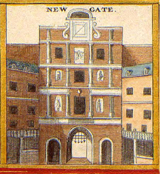
Newgate was one of the historic seven gates of the London Wall around the City of London and one of the six which date back to Roman times. Newgate lay on the west side of the wall and the road issuing from it headed over the River Fleet to Middlesex and western England. Beginning in the 12th century, parts of the gate buildings were used as a gaol, which later developed into Newgate Prison.

Holborn Viaduct is a road bridge in London and the name of the street which crosses it. It links Holborn, via Holborn Circus, with Newgate Street, in the City of London, England financial district, passing over Farringdon Street and the subterranean River Fleet. The viaduct spans the steep-sided Holborn Hill and the River Fleet valley at a length of 1,400 feet (430 m) and 80 feet (24 m) wide. City surveyor William Haywood was the architect and the engineer was Rowland Mason Ordish.
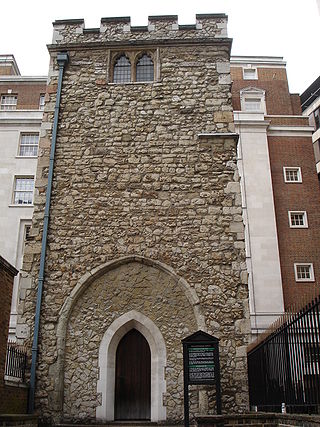
All Hallows Staining was a Church of England church located at the junction of Mark Lane and Dunster Court in the north-eastern corner of Langbourn ward in the City of London, England, close to Fenchurch Street railway station. All that remains of the church is the tower, built around AD 1320 as part of the second church on the site. Use of the grounds around the church is the subject of the Allhallows Staining Church Act 2010.

Hanover Square is a green square in Mayfair, Westminster, south west of Oxford Circus where Oxford Street meets Regent Street. Six streets converge on the square which include Harewood Place with links to Oxford Street, Princes Street, Hanover Street, Saint George Street, Brook Street and Tenderden Street, linking to Bond Street and Oxford Street.

Christ Church Greyfriars, also known as Christ Church Newgate Street, was a church in Newgate Street, opposite St Paul's Cathedral in the City of London. Established as a monastic church in the thirteenth century, it became a parish church after the Dissolution of the Monasteries. Following its destruction in the Great Fire of London of 1666, it was rebuilt to the designs of Sir Christopher Wren. Except for the tower, the church was largely destroyed by bombing during the Second World War. The decision was made not to rebuild the church; the ruins are now a public garden.

Soho Square is a garden square in Soho, London, hosting since 1954 a de facto public park let by the Soho Square Garden Committee to Westminster City Council. It was originally called King Square after Charles II, and a much weathered statue of the monarch has stood in the square, with an extended interruption, since 1661, one year after the restoration of the monarchy.

Postman's Park is a public garden in central London, a short distance north of St Paul's Cathedral. Bordered by Little Britain, Aldersgate Street, St. Martin's Le Grand, King Edward Street, and the site of the former headquarters of the General Post Office (GPO), it is one of the largest open spaces in the City of London.

St. Martin's Le Grand is a former liberty within the City of London, and is the name of a street north of Newgate Street and Cheapside and south of Aldersgate Street. It forms the southernmost section of the A1 road. For many years St. Martin's Le Grand was "often used as a synonym for the chief postal authorities, as Scotland Yard is used to designate the police", the headquarters of the General Post Office having been there from 1829-1984.

St Nicholas Shambles was a medieval church in the City of London, which stood on the corner of Butcher Hall Lane and Newgate Street. It took its name from the Shambles, the butchers area in the west of Newgate Street. The church is first mentioned as St. Nicholas de Westrnacekaria. In 1253 Walter de Cantilupe, Bishop of Worcester granted indulgences to its parishioners.

In London, the Greyfriars was a Conventual Franciscan friary that existed from 1225 to 1538 on a site at the North-West of the City of London by Newgate in the parish of St Nicholas in the Shambles. It was the second Franciscan religious house to be founded in the country. The establishment included a conventual church that was one of the largest in London; a studium or regional university; and an extensive library of logical and theological texts. It was an important intellectual centre in the early fourteenth century, rivalled only by Oxford University in status. Members of the community at that time included William of Ockham, Walter Chatton and Adam Wodeham. It flourished in the fourteenth and fifteenth century but was dissolved in 1538 at the instigation of Henry VIII as part of the Dissolution of the Monasteries. Christ's Hospital was founded in the old conventual buildings, and the church was rebuilt completely by Sir Christopher Wren as Christ Church Greyfriars after the original church was almost completely destroyed in the Great Fire of London of 1666. The building now standing on the site, designed by Arup Group Limited, is currently occupied by Merrill Lynch.

Fore Street is a street in the City of London, England, near the Barbican Centre. It runs from Wood Street to Fore Street Avenue and is joined by Moor Lane on its north side. The street was extensively damaged by Nazi bombing during World War II and, following later development, nothing now remains of its original buildings other than St Giles-without-Cripplegate, which is a short distance away from the modern street.
Hinde Street is a street in the Marylebone district of the City of Westminster, London, that contains the Hinde Street Methodist Church and was home to the novelist Rose Macaulay until her death.
Essex Street is a street in the City of Westminster that runs from Milford Lane in the south to Strand in the north. It is joined by Little Essex Street on its western side and Devereux Court on the eastern side. It was laid out by Nicholas Barbon in around 1675 or 1680 and contains a number of listed buildings.

Milford Lane is a narrow street in the City of Westminster that runs from Strand in the north to a brief walkway section leading to Temple Place in the south. It is joined by Little Essex Street and Essex Street on its eastern side. Maltravers Street once joined the lane to Arundel Street, but ceased to exist when building work at 190 Strand was completed.

Orme Square is a private square in Bayswater, London, England, off the north side of Bayswater Road and on the north-west corner of Hyde Park, overlooking Kensington Gardens whose Orme Gate entrance takes its name from the square.

The Bull and Mouth Inn was a coaching inn in the City of London that dated from before the Great Fire of London in 1666. It was located between Bull and Mouth Street in the north and Angel Street in the south. It was once an important arrival and departure point for coaches from all over Britain, but particularly for the north of England and Scotland. It became the Queen's Hotel in 1830 but was demolished in 1887 or 1888 when new post office buildings were built in St Martin's Le Grand.

Angel Street, formerly known as Angel Alley, Angel Court, and Angell Street, is a street in the City of London that runs between King Edward Street in the west and St Martin's Le Grand in the east. Although dating back to at least 1542, no original buildings now remain due to the effects of the Great Fire of London, the London Blitz, and redevelopment.

Milk Street in the City of London, England, was the site of London's medieval milk market. It was the location of the parish church of St Mary Magdalen which was destroyed in the Great Fire of London in 1666 and then of Honey Lane Market and the City of London School. The street was seriously damaged by German bombing during the Second World War and has since been completely rebuilt. Nothing remains of its former buildings.
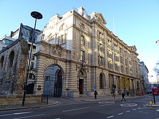
King Edward Building in the City of London was London's main Post Office for most of the 20th century and also the main sorting office for the London EC postal area and for overseas mail. Designed by Sir Henry Tanner, it was opened in 1910 and closed in the 1990s.

