Kingsland, London

Last updated

Kingsland
Greater London UK location map 2.svg
Red pog.svg
Kingsland
Location within Greater London
London borough
Ceremonial county Greater London
Region
Country England
Sovereign state United Kingdom
Post town LONDON
Dialling code 020
Police Metropolitan
Fire London
Ambulance London
London Assembly
List of places
UK
England
London
51°32′35″N0°04′44″W / 51.543°N 0.079°W / 51.543; -0.079 Coordinates: 51°32′35″N0°04′44″W / 51.543°N 0.079°W / 51.543; -0.079
Kingsland Waste. Kingsland waste hackney 1.jpg
Kingsland Waste.

Kingsland was a small road-side settlement centred on Kingsland High Street on the Old North Road (the present A10), around the junction with Dalston Lane. It is no longer discernable as a separate settlement, though the historic street pattern remains. Since the opening of Dalston Junction station in 1865, the area has become known as Dalston, which was originally a separate hamlet further east. Historically part of the county of Middlesex, the area is within the London Borough of Hackney. [1]

Contents

History

Origins

A map showing Kingsland ward of Shoreditch Metropolitan Borough as it appeared in 1916. Shoreditch Met. B Ward Map 1916.svg
A map showing Kingsland ward of Shoreditch Metropolitan Borough as it appeared in 1916.
A map showing the Kingsland ward of Hackney Metropolitan Borough as it appeared in 1916. Hackney Met. B Ward Map 1916.svg
A map showing the Kingsland ward of Hackney Metropolitan Borough as it appeared in 1916.

Kingsland derives its name from being the hunting grounds of a Tudor royal residence at Newington Green – hence King's Lands. At the time, the area was still heavily forested – as part of a forest stretching from Shoreditch to Enfield Chase – and roamed by wild bulls, stags and wild boars. [2] Deforestation occurred quickly as the demands of the nearby City took wood for building and firewood, and the cleared land was quarried for brick clay. There were many wells and springs in the district. The (now lost) Pigwell Brook had its source on Kingsland Green and followed the line of the modern Graham Road, before joining Hackney Brook in the region of Church Street (now the Narroway). Another chalybeate spring beyond Dalston was tapped and its water piped to Aldgate in 1535. [3]

The small villages of Kingsland, Dalston, Newington and Shacklewell were all situated within the Parish of Hackney and were grouped together for assessment purposes. Together they had only as many houses as the village of Hackney. In 1672, Kingsland had 28 householders assessed for hearth tax, but expanded rapidly in the 18th century, along the line of Kingsland Road, north of the junction, [4] and by 1724 had five inns, compared to Dalston's two. The road was heavily trafficked, including goods wagons pulled by six or more horses, and this caused the road surface to deteriorate. The local parishes appealed to Parliament in 1713 for the right to set up a Turnpike Trust, to pay for the necessary maintenance. Gates were installed at Kingsland and Stamford Hill to collect the tolls. [5] The village was still very rural, with market gardens established around the village. Large scale development began in 1807, again by the main road, and a new estate was created on Lamb farm, to the south and west of the junction. By 1831, building began along Dalston Lane, linking the two villages. [4]

In his youth, Samuel Pepys lodged in the village, for a while with his brother Tom and his nurse, Goody Lawrence. [6] Also, it is recorded that Pepys "used to shoot with bow and arrows" here in the 17th century. [1] [7]

Kingsland had a six-penny bath and a leper hospital, south of the green, also known as the 'Lock Hospital'. This was founded in 1280 by the City of London, as one of ten located on the main roads from the city. This continued until 1559 and the last case of leprosy in London. From 1549, the hospital was administered by St Bartholomew's Hospital, and treated other infectious diseases. After the Great Fire, St Bartholomew's no longer had the funds to support the Lock hospital, but patients were accepted if they could fund their own care – this continued until 1680, when again the main hospital was able to resume funding. [8] By 1669, there were six wards, by then for women only – male patients were sent to Southwark. The hospital was rebuilt in 1720, but closed in 1760. [9] The hospital had a chapel, dedicated to St Bartholomew. This was used, informally, as a chapel of ease, saving residents the walk to church at the parish church in Hackney. At the closure of the hospital, local people petitioned to keep the chapel open; it was never repaired and was in poor condition in the 1820s, being demolished in 1846. [9]

Disappearing district

Before the railway came: This plaque, on a block of houses near the top of Kingsland Road, is from a time when the name could still be used with some confidence. (October 2005) Kingsland place.jpg
Before the railway came: This plaque, on a block of houses near the top of Kingsland Road, is from a time when the name could still be used with some confidence. (October 2005)

The main part of the village was located near Dalston junction where the road to Hackney left the main road, and today this is only commemorated by the name of Kingsland Shopping centre. However, the name of Kingsland is still seen in street and station names, and on some modern maps, [10] but the district no longer appears on road signs as a destination. The various parts of the original district have now been absorbed into surrounding areas, for instance, the area of Kingsland to the east of Kingsland Road is now the ward of Queensbridge within the Borough of Hackney.

Before the arrival of the railways, in about 1850, Kingsland was the dominant village, which is why the section of the A10 road that is modern Dalston's main shopping centre is Kingsland High Street, and why Kingsland Road, not Dalston Road, extends south from the junction. Dalston was previously the name for a less important settlement situated further east, at the junction of Dalston Lane and Cecilia Road.

The North London Railway was opened in 1865, and adopted Dalston Junction as the name of the junction and new station – one of the most important on the line, since it connected directly with the City. Over time, the area round the junction became known by the name of the station – a common phenomenon in London.

Education

Transport and locale

Districts within the London Borough of Hackney. Hackney districts.gif
Districts within the London Borough of Hackney.

Opened in June 2010, the nearest London Overground stations are Dalston Junction and Dalston Kingsland

Related Research Articles

<span class="mw-page-title-main">London Borough of Hackney</span> Borough in United Kingdom

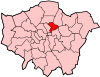
The London Borough of Hackney is a London borough in Inner London. The historical and administrative heart of Hackney is Mare Street, which lies 5 miles (8 km) north-east of Charing Cross. The borough is named after Hackney, its principal district. Southern and eastern parts of the borough are popularly regarded as being part of east London, with the northwest belonging to north London. Its population is 281,120 inhabitants.

<span class="mw-page-title-main">Dalston</span> Human settlement in England

Dalston is an area of East London, in the London Borough of Hackney. It is four miles northeast of Charing Cross. Dalston began as a hamlet on either side of Dalston Lane, and as the area urbanised the term also came to apply to surrounding areas including Kingsland and Shacklewell, all three of which being part of the Ancient Parish of Hackney.

<span class="mw-page-title-main">Homerton</span> Human settlement in England

Homerton is an area in London, England, in the London Borough of Hackney. It is bordered to the west by Hackney Central, to the north by Lower Clapton, in the east by Hackney Wick, Leyton and by South Hackney to the south. In 2019, it had a population of 14,658 people. In terms of ethnicity it was 43.9% White, 33.0% Black, 10.9% Asian and 7.8% Mixed. It covered an area of 0.830 sq kilometres. Homerton ward on Hackney Borough Council is currently represented by three Labour councillors. There are fifty listed buildings located within the boundaries of the ward.

<span class="mw-page-title-main">Shoreditch</span> Human settlement in England

Shoreditch is a district in the East End of London in England, and forms the southern part of the London Borough of Hackney. Neighbouring parts of Tower Hamlets are also perceived as part of the area.

<span class="mw-page-title-main">Stoke Newington</span> Area in London, England

Stoke Newington is an area occupying the north-west part of the London Borough of Hackney in north-east London, England. It is five miles northeast of Charing Cross. The Manor of Stoke Newington gave its name to Stoke Newington the ancient parish.

<span class="mw-page-title-main">Metropolitan Borough of Hackney</span>

The Metropolitan Borough of Hackney was a Metropolitan borough of the County of London from 1900 to 1965. Its area became part of the London Borough of Hackney.

<span class="mw-page-title-main">Metropolitan Borough of Stoke Newington</span>

The Metropolitan Borough of Stoke Newington was a metropolitan borough in the County of London between 1900 and 1965 when it became part of the London Borough of Hackney.

<span class="mw-page-title-main">Dalston Kingsland railway station</span> London Overground station

Dalston Kingsland railway station is a railway station on the North London Line in London, England. It is in the Dalston area of the London Borough of Hackney, on the western side of Kingsland High Street and opposite Ridley Road Market. The station and all trains serving it are operated by London Overground. It is in Travelcard Zone 2. Kingsland railway station was first opened on the site in 1850, but was replaced by Dalston Junction in 1865. The current station was opened by British Rail in 1983. Ticket barriers are in operation. The station straddles the boundary with the London Borough of Islington, with part of the platforms falling within Islington.

<span class="mw-page-title-main">Kingsland Road</span>

Kingsland Road is the name given to an East London stretch of the A10 road within the London Borough of Hackney in England. The A10 was originally a Roman Road better known as Ermine Street or sometimes the Old North Road.

<span class="mw-page-title-main">De Beauvoir Town</span> Human settlement in England

De Beauvoir Town is a neighbourhood in east London and is in the London Borough of Hackney, 2 miles (3.2 km) north of the City of London. The area was a part of Hackney, the Ancient Parish and subsequent Metropolitan Borough that was incorporated into the larger modern borough. It is sometimes described as a part of Dalston, which is in turn, also a part of the former parish and borough of Hackney.

<span class="mw-page-title-main">Hackney Central</span> Human settlement in England

Hackney Central is a sub-district of Hackney in the London Borough of Hackney in London, England and is four miles (6.4 km) northeast of Charing Cross.

<span class="mw-page-title-main">Shacklewell</span> Human settlement in England

Shacklewell is a small locality to the east of Roman Ermine Street, in the London Borough of Hackney.

Stoke Newington was an ancient parish in the county of Middlesex. It was both a civil parish, used for administrative purposes, and an ecclesiastical parish of the Church of England.

<span class="mw-page-title-main">Hackney (parish)</span>

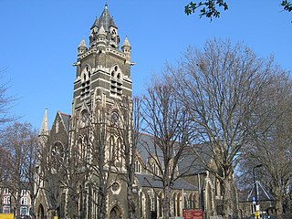
Hackney was a parish in the historic county of Middlesex. The parish church of St John-at-Hackney was built in 1789, replacing the nearby former 16th-century parish church dedicated to St Augustine. The original tower of that church was retained to hold the bells until the new church could be strengthened; the bells were finally removed to the new St John's in 1854. See details of other, more modern, churches within the original parish boundaries below.

<span class="mw-page-title-main">Clapton Square</span> Garden square in Lower Clapton in the London Borough of Hackney

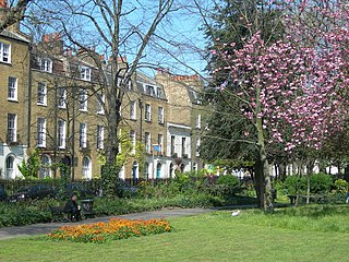
Clapton Square is the second largest garden square in the London Borough of Hackney, located in Lower Clapton, Clapton. It is lined by buildings on three sides. Its Conservation Area designated in 1969 – extended in 1991 and 2000 – takes in a larger green space separated by a stretch of open road: St John's Gardens. Those gardens have the tallest and largest building visible from all parts of the square's garden, the Church of St John-at-Hackney, rebuilt in 1792-97 which contains older monuments. Two sides of the square are lined with tall, partly stone-dressed, classical, Georgian terraced houses.

<span class="mw-page-title-main">Southgate Road</span> Human settlement in England

Southgate Road is a street in London, England, that runs from Baring Street in the south to the junction with Mildmay Park and Ball's Pond Road in the north. The street forms a part of the B102 road, leading from Newington Green to The City. The west side of Southgate Road is in the London Borough of Islington; and the east side is in the London Borough of Hackney. Southgate Road lies north of the Regent's Canal, west of De Beauvoir Town and east of Essex Road.

Kingsland Viaduct is a railway viaduct about 2 miles (3 km) in length, almost wholly within the present London Borough of Hackney in the north-east part of Inner London. It was built in the 1860s, but was disused from 1986 until it was reopened to carry the London Overground in 2010. The viaduct is owned by Transport for London. Since then it has carried East London Line services between Shoreditch High Street and Dalston.

<span class="mw-page-title-main">North London Line City Branch</span>

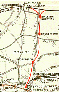
The City Branch was a short spur of the North London Line allowing direct access from the east-west main route of the North London Railway to the terminus at Broad Street in the City of London.

<span class="mw-page-title-main">West Hackney</span> Human settlement in England

West Hackney is a district in the London Borough of Hackney, situated on the eastern side of Ermine Street, the major Roman Road better known as the A10.

<span class="mw-page-title-main">Hackney, London</span> Human settlement in England

Hackney is a district in East London, England, forming around two-thirds of the area of the modern London Borough of Hackney, to which it gives its name. It is 4 miles (6.4 km) northeast of Charing Cross and includes part of the Queen Elizabeth Olympic Park. Historically it was within the county of Middlesex.

References

  1. 1 2 Cherry and Pevsner (1988) London 4: North: 475
  2. The northern suburbs: Hoxton, Kingsland and Dalston, Old and New London: Volume 5 (1878), pp. 524–530. Date accessed: 9 March 2009
  3. Largest Parish in Middlesex Archived 21 November 2008 at the Wayback Machine (Tudor Hackney – from the National Archives; accessed 7 March 2009
  4. 1 2 Hackney: Dalston and Kingsland Road, A History of the County of Middlesex: Volume 10: Hackney (1995), pp. 28–33 accessed: 7 December 2007
  5. Georgian Transport Archived 15 March 2018 at the Wayback Machine (Brickfields Spitalfields) accessed 18 May 2009
  6. C. S. Knighton, Pepys, Samuel (1633–1703), Oxford Dictionary of National Biography, (Oxford University Press, 2004).
  7. See also: Pepys Diary 12 May 1667
  8. Religious Houses: Hospitals, A History of the County of Middlesex: Volume 1: Physique, Archaeology, Domesday, Ecclesiastical Organization, The Jews, Religious Houses, Education of Working Classes to 1870, Private Education from Sixteenth Century (1969), pp. 204–212. accessed: 10 April 2009
  9. 1 2 Hackney's First Hospital Archived 21 November 2008 at the Wayback Machine (Tudor Hackney – from the National Archives; accessed 7 March 2009
  10. See London A-Z (2005), for example

Bibliography