Kinyeti River

Last updated

Coordinates: 4°45′53″N32°28′00″E / 4.76472°N 32.46667°E / 4.76472; 32.46667 The Kinyeti River flows northward from the Imatong Mountains in the Imatong State state of South Sudan, eventually dispersing into the Badigeru swamp.

Geographic coordinate system Coordinate system

A geographic coordinate system is a coordinate system that enables every location on Earth to be specified by a set of numbers, letters or symbols. The coordinates are often chosen such that one of the numbers represents a vertical position and two or three of the numbers represent a horizontal position; alternatively, a geographic position may be expressed in a combined three-dimensional Cartesian vector. A common choice of coordinates is latitude, longitude and elevation. To specify a location on a plane requires a map projection.

Imatong Mountains mountains in South Sudan

The Imatong Mountains are mainly located in Imatong State in southeastern South Sudan, and extend into the Northern Region of Uganda. It was earlier a part of Eastern Equatoria before reorganisation of states.

Imatong State State in Torit, South Sudan

Imatong State is one of the 28 states of South Sudan. It is located in the Equatoria region and it borders Yei River to the southwest, Jubek to the west, Terekeka and Jonglei to the northwest, Boma to the northeast, Namorunyang to the east, and Uganda to the south.

Contents

Location

The Imatongs reach out from their highest central block around Mount Kinyeti into a northwestern, western and southwestern chain. The western chain, with peaks rising up to 2,500 metres (8,200 ft) high, is usually known as the Acholi Mountains. The Kinyeti valley lies between the northwest and west ranges. [1] The Kinyeti river, and others that drain the northern slopes of the mountains, feed the Badigeru swamps. These swamps, running in a SSW-NNE direction for 100 kilometres (62 mi), are discontinuous. They may be as wide as 25 kilometres (16 mi) in the rainy season, but average 5 kilometres (3.1 mi) in width. The swamps in turn may drain westward into the Bahr el Jebel section of the White Nile or eastward into the Veveno River. [2]

White Nile river in Africa and tributary of the Nile River

The White Nile is a river in Africa, one of the two main tributaries of the Nile; the other is the Blue Nile. The name comes from colouring due to clay carried in the water.

The Veveno River is a river in eastern South Sudan. It is a tributary of the Lotilla River, which it joins southwest of Pibor.

Colonial era

The British colonial administration began a forestry project in the Kinyeti basin in the 1940s, clearing the natural forest and planting fast-growing softwoods, Cyprus and Pine. In 1950 the mountains above 1,500 metres (4,900 ft) were made a forest reserve with no further settlement permitted, but the ban was not enforced during the civil wars. Forestry brought laborers into the mountains, and they started hillside farming in a wide area around the forest plantations. [3] In 1949 fingerling trout supplied by the Kenya Game Department were put out in the upper Kinyeti River. By 1952 they had become established, and the forestry department was planning to stock other streams using trout from the Kinyeti. [4]

Later developments

Shortly before independence, the government announced that the Army's Equatoria Corps was to be transferred to the North, sparking a mutiny on 18 August 1955. 336 northerners died and 75 southerners, of whom 55 drowned in the Kinyeti after they fled in panic from Torit. [5] Forestry was neglected during the First Sudanese Civil War (1955-1972). After 1972 an effort was made to rehabilitate the plantations, with a new road built from Torit, a hydro-electric scheme developed to power sawmills and other changes. As of 1984 only the steepest slopes had natural forest and there were plans to clear-cut most of the Kinyeti basin. [3] A 1981 feasibility study assessed hydroelectric power potential in the Kinyeti River and the local power demand, but there was no follow-up. [6] The most promising site seemed to be at Katire. [7]

Torit Municipality in Imatong State, South Sudan

Torit is a town in South Sudan.

The First Sudanese Civil War was a conflict from 1955 to 1972 between the northern part of Sudan and the southern Sudan region that demanded representation and more regional autonomy. Half a million people died over the 17 years of war, which may be divided into three stages: initial guerrilla war, Anyanya, and South Sudan Liberation Movement.

Related Research Articles

Nile River in Africa and the longest river in the world

The Nile is a major north-flowing river in northeastern Africa, and is the longest river in Africa and in the world, though some sources cite the Amazon River as the longest. The Nile, which is about 6,650 km (4,130 mi) long, is an "international" river as its drainage basin covers eleven countries, namely, Tanzania, Uganda, Rwanda, Burundi, the Democratic Republic of the Congo, Kenya, Ethiopia, Eritrea, South Sudan, Republic of the Sudan and Egypt. In particular, the Nile is the primary water source of Egypt and Sudan.

Agusan River river located in the eastern part of Mindanao island in the Philippines

Agusan River is a river in the Philippines, located in the north-eastern part of Mindanao island, draining majority of the Caraga region and some parts of Compostela Valley province. It is the country's third largest river basin with a total drainage area of 11,937 square kilometres (4,609 sq mi) and an estimated length of 390 kilometres (240 mi) from its origin. The headwaters of the river are found in the mountains of Compostela Valley, near its border with Davao Oriental and east of Tagum City. It flows through the wide Agusan River valley which measures 177 kilometers (110 mi) from south to north and varies from 32–48 kilometers in width. It finally drains into the Butuan Bay at its mouth in Butuan City.

Gezira Scheme

The Gezira Scheme is one of the largest irrigation projects in the world. It is centered on the Sudanese state of Al Jazirah, just southeast of the confluence of the Blue and White Nile rivers at the city of Khartoum. The Gezira Scheme was begun by the British while the area was governed as part of Anglo-Egyptian Sudan. Water from the Blue Nile is distributed through canals and ditches to tenant farms lying between the Blue and White Nile rivers.

Kinyeti mountain

Mount Kinyeti is the highest peak in South Sudan. It is located in the Imatong Mountains in Ikwoto County of Imatong State state, near the Ugandan border. It was earlier located in Eastern Equatoria before the reorganisation of states. Kinyeti has an elevation of 3,187 metres (10,456 ft) above sea level. The group of high mountains that contain Kinyeti, extending to the border with Uganda, are sometimes called the Lomariti or Lolobai mountains.

Magwi County

Magwi County, also Magwe County, is a county in South Sudan.

Bahr el Zeraf river in South Sudan

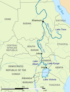
The Bahr el Zeraf, or Zeraf River in the English language, is an arm of the White Nile in the Sudd region of South Sudan. It is completely contained within the South Sudanese state of Jonglei. Its name is Arabic for "Giraffe River".

Nyabarongo River river in Rwanda

The Nyabarongo is a major river in Rwanda, part of the upper headwaters of the Nile. At 297 km, it is the longest river entirely in Rwanda. The river begins its course at the confluence of the rivers Mbirurume and Mwogo in the South West of the country. These two rivers themselves begin in Nyungwe Forest, and are considered by some to be the most distant source of the Nile. From its start, Nyabarongo flows northward for 85 km, and forms the border between the Western and Southern Provinces. At the confluence with the river Mukungwa, the river changes course and flows eastward for 12 km, then to a more South Eastern course for the last 200 km. For the longest stretch of this course, the river serves as the boundary between the Northern and Southern Provinces, then between the City of Kigali and the Southern Province, and lastly between the City of Kigali and the Eastern Province. The river then before enters the Eastern Province and ends its course close to the border with Burundi. The Nyabarongo River empties both in Lake Rweru and Akagera river in a small but complicated Delta. The Akagera river outflows from Lake Rweru, a mere 1 km from the Nyabarongo delta. Almost all the branches of the Nyabarongo delta empty in the lake, however, one branch of the delta empties directly in the just formed Akagera river. The Akagera River eventually flows into Lake Victoria and forms the Nile.

Torit County Place in Imatong State, South Sudan

Torit County is an administrative region in Imatong State of South Sudan, with headquarters in the town of Torit, which is also the state capital.

The Koss River is a river that flows in a north of northwest direction through the erstwhile Eastern Equatoria state of South Sudan, fed by streams from the Imatong Mountains to the west.

Ikotos County Place in Eastern Equatoria, South Sudan

Ikotos County was an administrative area in the Eastern Equatoria state of South Sudan with headquarters in the town of Ikotos. The people, who live in the former county's area by subsistence agriculture and cattle herding, are poverty-stricken. Years of civil war have made violence commonplace: most people have experienced the murder of a close family member. In 2009, AK-47 rifles were used in 42 per cent of killings.

Tirangore in Eastern Equatoria, South Sudan

Tirangore is a village in the Hiyala Payam of Torit county in the Eastern Equatoria State of South Sudan. It lies to the northeast of Torit.

Geography of South Sudan

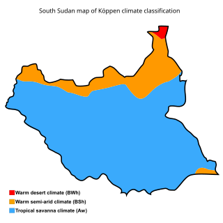
The geography of South Sudan describes the physical features of South Sudan, a country in East Africa. South Sudan is a landlocked country and borders - clockwise - Sudan from the north, Ethiopia from the east, Kenya, Uganda and the Democratic Republic of the Congo from the south and the Central African Republic from the west.

The Machar Marshes are a large area of wetlands in the state of Upper Nile, South Sudan. Estimates of their size vary. A 1950 study put the area of swamp at 6,500 km2. A 1980 study put the area of permanent swamp at 8,700 km2., 60% of which was grass and forest.

The Badigeru swamp swamp lies in South Sudan, in the Central Equatoria and Eastern Equatoria states between Terekeka and Lafon.

Congo-Nile Divide continental divide that separates the drainage basins of the Nile and Congo rivers

The Congo-Nile Divide is the continental divide that separates the drainage basins of the Nile and Congo rivers. It is about 2,000 kilometres (1,200 mi) long.

Ironstone Plateau

The Ironstone Plateau is a region in the south and west of South Sudan.

The Sudans is a region in Africa comprising the countries of Sudan and South Sudan.

References

  1. Friis, Ib; Vollesen, Kaj (1998). Flora of the Sudan-Uganda border area east of the Nile. Kgl. Danske Videnskabernes Selskab. pp. 9–10. ISBN   87-7304-297-8.
  2. R. H. Hughes; J. S. Hughes (1992). A directory of African wetlands. IUCN. p. 224. ISBN   2-88032-949-3.
  3. 1 2 Van Noordwijk, Meine (1984). Ecology textbook for the Sudan (PDF). Khartoum University Press. p. 221. ISBN   90-6224-114-X.
  4. Commercial fisheries review". 14 (10). October 1952 https://archive.org/stream/commercialfisher14101952unit/commercialfisher14101952unit_djvu.txt . Retrieved 2011-07-28.Missing or empty |title= (help)
  5. James Fearon; David Laitin. "Sudan" (PDF). Stanford University. Retrieved 2011-07-28.
  6. Terje Tvedt (2008). A Bibliography on the River Nile Vol. I (PDF). BRIC Press. p. 231. ISBN   978-82-7453-074-4 . Retrieved 2011-07-28.
  7. Ralph H. Brooks, Samuel E. Bunker, Ronald G. Domer, David R. Zoellner (July 1982). "Sudan An assessment of decentralized hydropower potential" (PDF). USAID. Retrieved 2011-07-28.