Kangen River

Last updated
Kangen River
Sobat OSM.png
Sobat River basin
South Sudan topographic map.svg
Red pog.svg
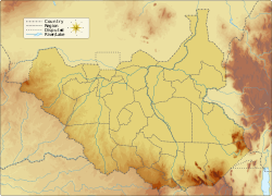
Location of mouth in South Sudan
Location
Country South Sudan
Physical characteristics
Mouth  
  coordinates
6°47′00″N33°09′00″E / 6.78333°N 33.15°E / 6.78333; 33.15 Coordinates: 6°47′00″N33°09′00″E / 6.78333°N 33.15°E / 6.78333; 33.15

The Kangen River is a river in South Sudan, just west of Boma National Park. It joins the Pibor River near Pibor.


See also


Related Research Articles

Jonglei State State of South Sudan

Jonglei State is a state of South Sudan with Bor as its centre of government and the biggest city. Jonglei state comprises nine counties: Bor, Akobo, Ayod, Uror, Duk, Nyirol, Pigi, Twic East, and Fangak. Jonglei State is the largest state by area before reorganisation, with an area of approximately 122,581 km2, as well as the most populous according to the 2008 census conducted in present-day South Sudan's second period of autonomy. The boundaries of the state were again changed as a result of a peace agreement signed on 22 February 2020.

Baro River River in southwestern Ethiopia

The Baro River or Baro/Openo Wenz, known to the Anuak as Openo River, is a river in southwestern Ethiopia, which defines part of Ethiopian border with South Sudan. From its source in the Ethiopian Highlands it flows west for 306 kilometres (190 mi) to join the Pibor River. The Baro-Pibor confluence marks the beginning of the Sobat River, a tributary of the White Nile.

Sobat River River in South Sudan

The Sobat River is a river of the Greater Upper Nile region in northeastern South Sudan, Africa. It is the most southerly of the great eastern tributaries of the White Nile, before the confluence with the Blue Nile.

Pibor River River in South Sudan and Ethiopia

The Pibor River is a river in eastern South Sudan, which defines part of South Sudan's border with Ethiopia. From its source near Pibor Post it flows north for about 320 kilometres (200 mi), joining the Baro River to form the Sobat River, which is a tributary of the White Nile.

The Akobo River is a river on the border between South Sudan and Ethiopia. From its source in the Ethiopian Highlands near Mizan Teferi it flows west for 434 kilometres (270 mi) to join the Pibor River. The Pibor flows into the Sobat River, which in turn empties into the White Nile.

Pibor Airport is an airport serving the town of Pibor, in South Sudan.

Akobo, South Sudan Place in Jonglei State, South Sudan

Akobo is a town in South Sudan.

Pibor Town in Pibor Administrative Area, South Sudan

Pibor, also called Pibor Post, is a town in South Sudan.

Sudanese nomadic conflicts Non-state conflicts between rival nomadic tribes

Sudanese nomadic conflicts are non-state conflicts between rival nomadic tribes taking place in the territory of Sudan and, since 2011, South Sudan. Conflict between nomadic tribes in Sudan is common, with fights breaking out over scarce resources, including grazing land, cattle and drinking water. Some of the tribes involved in these clashes have been the Messiria, Maalia, Rizeigat and Bani Hussein Arabic tribes inhabiting Darfur and West Kordofan, and the Dinka, Nuer and Murle African ethnic groups inhabiting South Sudan. Conflicts have been fueled by other major wars taking place in the same regions, in particular the Second Sudanese Civil War, the War in Darfur and the Sudanese conflict in South Kordofan and Blue Nile.

Counties of South Sudan

The 10 states and 3 administrative areas of South Sudan are divided into 79 counties.

Greater Upper Nile Region in South Sudan

The Greater Upper Nile is a region of northeastern South Sudan. It is named for the White Nile, a tributary of the Nile River in North and East Africa.

The Lotilla River is a river in South Sudan. It rises in marshes on the borders of the erstwhile Eastern Equatoria and Jonglei states and flows north to join the Pibor River near Pibor, at a junction with the Kangen River. The marshes are fed by the Medikiret River, which has its origins in marshes further south.

Agwei River

The Agwei River or the River Agwei, also spelled Agvey, is a tributary of the Pibor River that flows through eastern South Sudan. Its own tributaries include the Abara and Kongkong rivers. The river is a wadi, or ravine, that may run dry during the dry season but quickly becomes a watercourse due to heavy rainfall during the wet season.

The Veveno River is a river in eastern South Sudan by the Imatong Mountains. It is a tributary of the Lotilla River, which it joins southwest of Pibor.

Ethnic violence in South Sudan has a long history among South Sudan's varied ethnic groups. South Sudan has 64 tribes with the largest being the Dinkas, who constitute about 35% of the population and predominate in government. The second largest are the Nuers. Conflict is often aggravated among nomadic groups over the issue of cattle and grazing land and is part of the wider Sudanese nomadic conflicts.

David Yau Yau

David Yau Yau was the Chief Administrator of the Greater Pibor Administrative Area of South Sudan. He was previously the leader of a Murle insurrection against the South Sudanese government.

Pibor Administrative Area Administrative area in South Sudan

The Greater Pibor Administrative Area is an administrative area in South Sudan.

Boma State State of South Sudan

Boma State was a state in South Sudan that existed between 2 October 2015 and 22 February 2020. It was located in the Greater Upper Nile region and was formerly part of the state of Jonglei. The state bordered Akobo State, Imatong State, Jonglei State, Kapoeta State, Bieh State, Terekeka State and the country of Ethiopia to the east.