
Sudan is located in Northeast Africa. It is bordered by Egypt to the north, the Red Sea to the northeast, Eritrea and Ethiopia to the east, South Sudan to the south, the Central African Republic to the southwest, Chad to the west and Libya to the northwest. Sudan is the third largest country in Africa, after Algeria and the Democratic Republic of the Congo. It had been the largest country on the continent until the 2011 independence of South Sudan.

The Salinas River is the longest river of the Central Coast region of California, running 175 miles (282 km) and draining 4,160 square miles (10,800 km2). It flows north-northwest and drains the Salinas Valley that slices through the central California Coast Ranges south of Monterey Bay. The river begins in southern San Luis Obispo County, originating in the Los Machos Hills of the Los Padres National Forest. From there, the river flows north into Monterey County, eventually making its way to connect with the Monterey Bay, part of the Pacific Ocean, approximately 5 miles (8.0 km) south of Moss Landing. The river is a wildlife corridor, and provides the principal source of water from its reservoirs and tributaries for the farms and vineyards of the valley.

The Luangwa River is one of the major tributaries of the Zambezi River, and one of the four biggest rivers of Zambia. The river generally floods in the rainy season and then falls considerably in the dry season. It is one of the biggest unaltered rivers in Southern Africa and the 52,000 square kilometres (20,000 sq mi) that make up the surrounding valley are home to abundant wildlife.

The Vedavathi is a river in India. It rises from the Bababudanagiri Mountains of Western Ghats and flows through the states of Karnataka and Andhra Pradesh. The Vedavathi is also called the Hagari in Bellary District of Karnataka and parts of Andhra Pradesh. Two rivers, the Veda and Avathi, arise in the eastern part of the Sahyadri Hill range in Bababudangiri mountain ranges, flow east, and join near Pura to form the Vedavathi River. From there the river flows through Kadur Taluk Of Chikkamagalur District. Then it enters Hosadurga Taluk, Hiriyur Taluk and Challakere Taluk of Chitradurga district, respectively.

The Runde River is a river in southeastern Zimbabwe. It is a tributary of the Save River and its major tributaries include the Ngezi River, Tokwe River, Mutirikwe River and Chiredzi River.

The Oti River or Pendjari River is an international river in West Africa. It rises in Benin, forms the border between Benin and Burkina Faso, flows through Togo, and joins the Volta River in Ghana.
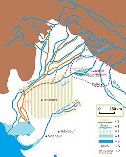
The Ghaggar-Hakra River is an intermittent river in India and Pakistan that flows only during the monsoon season. The river is known as Ghaggar in India, before the Ottu barrage, and as the Hakra in Pakistan, downstream of the barrage, ending in the Thar desert. In pre-Harappan times the Hakra was a tribuary of the Sutlej. It is still connected to this paleochannel of the Sutlej, and possibly the Yamuna, which ended in the Nara River, presently a delta channel of the Indus River joining the sea via Sir Creek.
Pahuj River is a river flowing through the city of Jhansi, Uttar Pradesh, India. It has been referred as the Pushpavati in religious texts. It is a small and dry river which passes through the Indian Grassland and Fodder Research Institute, Jhansi. It flows through the region of Bundelkhand region and a plays a major part in dividing the border of Uttar Pradesh and Madhya Pradesh. Generally it flows at a heavy water level outside its banks in the monsoon season but drastically can also go dry or with very little flow in the summers. Nowadays many electric plants in Uttar pradesh are discharging its waste in it due to which the water of the river getting contaminated day by day and also illegal mining at the banks of it is causing its state deteriorating day by day.
Dry Creek is a stream in Stanislaus County, California, that is a tributary to the Tuolumne River.

The Luena River of Zambia's Western Province rises just west of the Kafue National Park and flows west through Kaoma to become a tributary of the Zambezi. In the dry season, just below its confluence with its seasonal tributary the Luampa River, it ends in swamps or marshes on the Luena Flats east of Lukulu. In the wet season the Luena Flats flood and overflow into the Ndandu channel or floodplain which leads south-west to the Barotse Floodplain of Zambezi north of Limulunga and Mongu. It is the widest 'tributary' floodplain of the Barotse Floodplain, reaching 20 km wide at its mouth.
The Kushiyara River is a distributary river in Bangladesh and Assam, India. It forms on the India-Bangladesh border as a branch of the Barak River, when the Barak separates into the Kushiyara and Surma. The waters of the Kushiyara thus originate in the state of Nagaland in India and pick up tributaries from Manipur, Mizoram and Assam.

Tropical savanna climate or tropical wet and dry climate is a type of climate that corresponds to the Köppen climate classification categories Aw and As. The driest month has less than 60 mm (2.4 in) of precipitation and also less than of precipitation.
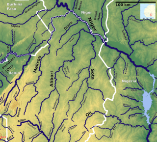
The Sota is a river of northern Benin flowing through the departments of Borgou and Alibori. It is a tributary of the Niger River and the Tassiné River is one of its tributaries. The river is approximately 250 km in length and covers a basin area of 13,650 km2.

The Kopai River is a tributary of the Bakreshwar River. It flows past such towns as Santiniketan, Bolpur, Kankalitala, Kirnahar and Labhpur in Birbhum district in the Indian state of West Bengal. It is a small river in dry season but overflows its banks during the monsoon. There is a name Chhora (ছোড়া) beside this river. Also Nichinta (নিচিন্তা), Rupuspur (রুপুসপুর), Perua, (পেরুয়া) etc are depend on this river.

Tezonapa is a municipality located in the high mountains region in the State of Veracruz, Mexico, about 219 km from state capital Xalapa. It covers an area of 351 square kilometres (136 sq mi). The law number 93 of December 22, 1960 San Agustín created Tezonapa's municipality with the congregations of the Josefinas, Prison, Tezonapa, Palmarito, etc.
The Kolong River or Kailang is an anabranch of the Brahmaputra River, which diverts out from the Brahamputra river in Hatimura region of Jakhalabandha, and meets the same at Kolongpar near Guwahati. The tributary is about 250 kilometres (160 mi) long and flows through the districts of Nagaon, Morigaon and Kamrup; on the way, several smaller streams meet it. The river flows through the heart of the Nagaon urban area dividing the town into Nagaon and Haiborgaon.
The Tupiza River is a seasonal river located in Bolivia in the Potosí Department, in the Sud Chichas Province. The Tupiza River is a mainly seasonal river; it dries up during the dry season, and becomes full in the wet season. It flows for 28 miles southeast, towards Paraguay, before ending west of Tarija.

Tulcingo (municipality) is a town and municipality in Puebla in south-eastern Mexico.
The Kongkong River, also spelled Kong Kong, is a stream in the South Sudanese state of Jonglei, west of Boma National Park near the Ethiopian border. At the village of Bongak it joins the Abara River to form the Agwei or Agvey River, a tributary of the Pibor River. It is within the drainage basin of the White Nile.
The Abara River, also known as Abara Khawr, is a stream in Jonglei, South Sudan. It is a tributary of the Agwei River. The Abara meets the Kongkong River to form the Agwei just east of Bongak. The stream is a wadi, or ravine, that may run dry during the dry season but quickly becomes a watercourse due to heavy rainfall during the wet season.

