Kiowa Rural Township, Kiowa County, Kansas

Last updated

Kiowa Rural Township
Map highlighting Kiowa Township, Kiowa County, Kansas.svg
Map of Kiowa County
Coordinates: 37°25′46″N99°29′33″W / 37.42944°N 99.49250°W / 37.42944; -99.49250
Country United States
State Kansas
County Kiowa
Area
  Total722.39 sq mi (1,871.0 km2)
  Land722.19 sq mi (1,870.5 km2)
  Water0.2 sq mi (0.5 km2)  0.03%
Elevation
[1]
2,182 ft (665 m)
Population
 (2000)
  Total3,278
  Density4.538/sq mi (1.752/km2)
Time zone UTC-6 (Central (CST))
  Summer (DST) UTC-5 (CDT)
Area code 620
GNIS feature ID 0470707

Kiowa Rural Township is the sole township in Kiowa County, Kansas, United States. The population was 3,278 at the 2000 census, out of whom 2,346 lived in one of the township's three cities and 813 lived in unincorporated areas of the township. [2] Kiowa Rural Township's boundaries are identical to those of Kiowa County: there are no other townships in the county, and none of the county's cities are governmentally independent. [3]

Contents

History

Kiowa Rural Township was once named simply "Kiowa Township." [1] It has not always been the only township in the county: until 1980-01-01, when all existing townships in the county were dissolved, [4] there was also Martin Township, located near Mullinville in the western part of the county, [5] and Wellsford Township (previously Dowell Township), located near Haviland in the eastern part of the county. [6] Even these three townships were significantly expanded from past years; in 1940, Kiowa County was composed of fifteen townships: Brenham, Butler, Center, Garfield, Glick, Highland, Kiowa, Lincoln, Martin, Reeder, Union, Ursula, Valley, Wellsford, and Westland. [7] Although it includes the territories of those former townships, Kiowa Rural Township itself is not important to local government, having become inactive. [1]

Geography

Because Kiowa Rural Township is coterminous with the county, its statistics are similar to the county's. It covers an area of 722.39 square miles (1871.0 square kilometers); [8] of this, 0.2 square miles (0.5 square kilometers) or 0.03%, is water. [9]

Six cemeteries are located in the township: Belvidere, [10] Boles, [11] Fairview, [12] Haviland, [13] Hillcrest, [14] and McKinley. [15]

Communities

Seven populated places are located in Kiowa Rural Township: [1]

Adjacent townships

Transportation

Major highways in Kiowa Rural Township include U.S. Routes 54, 183, and 400. [16] As well, two airports are located in the township: Gail Ballard Municipal Airport [17] and Paul Windle Municipal Field. [18]

Related Research Articles

<span class="mw-page-title-main">Kiowa County, Kansas</span> County in Kansas, United States

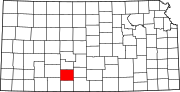
Kiowa County is a county located in the U.S. state of Kansas. Its county seat and largest city is Greensburg. As of the 2020 census, the county population was 2,460. The county is named after the Kiowa tribe.

<span class="mw-page-title-main">Haviland, Kansas</span> City in Kiowa County, Kansas

Haviland is a city in Kiowa County, Kansas, United States. As of the 2020 census, the population of the city was 678. It is home of Barclay College and known for meteorite finds connected to the Haviland Crater and for an annual meteorite festival held in July.

<span class="mw-page-title-main">Mullinville, Kansas</span> City in Kiowa County, Kansas

Mullinville is a city in Kiowa County, Kansas, United States. As of the 2020 census, the population of the city was 197.

<span class="mw-page-title-main">Brookfield Township, Huron County, Michigan</span> Civil township in Michigan, United States

Brookfield Township is a civil township of Huron County in the U.S. state of Michigan. As of the 2000 census, the township population was 914.

<span class="mw-page-title-main">Cowanshannock Township, Armstrong County, Pennsylvania</span> Township in Pennsylvania, United States

Cowanshannock Township is a township in Armstrong County, Pennsylvania, United States. The population was 2,742 at the 2020 census, a decrease from the figure of 2,899 tabulated in 2010.

<span class="mw-page-title-main">Madison Township, Armstrong County, Pennsylvania</span> Township in Pennsylvania, United States

Madison Township is a township in Armstrong County, Pennsylvania, United States. The population was 826 at the 2020 census, an increase over the figure of 820 tabulated in 2010.

<span class="mw-page-title-main">Mahoning Township, Armstrong County, Pennsylvania</span> Township in Pennsylvania, United States

Mahoning Township is a township in Armstrong County, Pennsylvania, United States. The population was 1,406 at the 2020 census, a decrease from 1,425 at the 2010 census.

<span class="mw-page-title-main">Manor Township, Armstrong County, Pennsylvania</span> Township in Pennsylvania, United States

Manor Township is a township in Armstrong County, Pennsylvania, United States. The population was 4,190 at the 2020 census, a decrease from the figure of 4,227 tabulated in 2010.

<span class="mw-page-title-main">South Buffalo Township, Armstrong County, Pennsylvania</span> Township in Pennsylvania, United States

South Buffalo Township is a township in Armstrong County, Pennsylvania, United States. The population was 2,713 at the 2020 census, an increase from the figure of 2,636 tabulated in 2010.

<span class="mw-page-title-main">Washington Township, Armstrong County, Pennsylvania</span> Township in Pennsylvania, United States

Washington Township is a township in Armstrong County, Pennsylvania, United States. The population was 898 at the 2020 census, a decrease from 923 at the 2010 census.

<span class="mw-page-title-main">Wayne Township, Armstrong County, Pennsylvania</span> Township in Pennsylvania, United States

Wayne Township is a township that is located in Armstrong County, Pennsylvania, United States.

<span class="mw-page-title-main">Belvidere, Kansas</span> Unincorporated community in Kiowa County, Kansas

Belvidere is an unincorporated community in Kiowa County, Kansas, United States, and located along the Medicine Lodge River.

<span class="mw-page-title-main">Medicine Lodge River</span> River in the United States

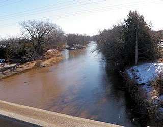
The Medicine Lodge River is a 130-mile-long (210 km) tributary of the Salt Fork of the Arkansas River in southern Kansas and northern Oklahoma in the United States. Via the Salt Fork and Arkansas rivers, it is part of the watershed of the Mississippi River.

<span class="mw-page-title-main">Avilla Township, Comanche County, Kansas</span> Township in Kansas, United States

Avilla Township is a township in Comanche County, Kansas, United States. As of the 2000 census, its population was 58.

<span class="mw-page-title-main">Protection Township, Comanche County, Kansas</span> Township in Kansas, United States

Protection Township is a township in Comanche County, Kansas, United States. As of the 2000 census, its population was 734.

<span class="mw-page-title-main">Hill City Township, Graham County, Kansas</span> Township in Kansas, United States

Hill City Township is a township in Graham County, Kansas, USA. As of the 2000 census, its population was 1,747.

<span class="mw-page-title-main">Cecil Township, Bottineau County, North Dakota</span> Township in North Dakota, United States

Cecil Township is a civil township in Bottineau County in the U.S. state of North Dakota. As of the 2000 census, its population was 28.

<span class="mw-page-title-main">Wellsford, Kansas</span> Unincorporated community in Kiowa County, Kansas

Wellsford is an unincorporated community in Kiowa County, Kansas, United States.

<span class="mw-page-title-main">Brenham, Kansas</span> Unincorporated community in Kiowa County, Kansas

Brenham is an unincorporated community in Kiowa County, Kansas, United States.

<span class="mw-page-title-main">Joy, Kansas</span> Unincorporated community in Kiowa County, Kansas

Joy is an unincorporated community in Kiowa County, Kansas, United States.

References

  1. 1 2 3 4 U.S. Geological Survey Geographic Names Information System: Kiowa Rural Township, Kiowa County, Kansas
  2. "Subcounty population estimates: Kansas 2000-2006". United States Census Bureau, Population Division. June 28, 2007. Archived from the original (CSV) on April 20, 2008. Retrieved May 28, 2008.
  3. Detailed Kansas map, United States Census Bureau. Accessed 2008-06-24.
  4. General Highway Map of Kiowa County, Kansas, Kansas Department of Transportation, 1977, with 1981-07-06 update. Accessed 2008-07-07.
  5. U.S. Geological Survey Geographic Names Information System: Martin Township
  6. U.S. Geological Survey Geographic Names Information System: Wellsford Township
  7. Kansas Counties: Kiowa County, Kansas Archived 2007-11-19 at the Wayback Machine , Kansas State Historical Society, 2008. Accessed 2008-06-24.
  8. Kiowa County Quickfacts [ permanent dead link ], United States Census Bureau, 2008-01-02. Accessed 2008-06-24.
  9. Kiowa Rural township, Kiowa County, Kansas (KS), City-Data.com, 2007. Accessed 2008-06-24.
  10. U.S. Geological Survey Geographic Names Information System: Belvidere Cemetery
  11. U.S. Geological Survey Geographic Names Information System: Boles Cemetery
  12. U.S. Geological Survey Geographic Names Information System: Fairview Cemetery
  13. U.S. Geological Survey Geographic Names Information System: Haviland Cemetery
  14. U.S. Geological Survey Geographic Names Information System: Hillcrest Cemetery
  15. U.S. Geological Survey Geographic Names Information System: McKinley Cemetery
  16. Rand McNally. The Road Atlas '08. Chicago: Rand McNally, 2008, p. 40.
  17. U.S. Geological Survey Geographic Names Information System: Gail Ballard Municipal Airport
  18. U.S. Geological Survey Geographic Names Information System: Paul Windle Municipal Field