
Batley is a market town in the Metropolitan Borough of Kirklees, West Yorkshire, England, south-west of Leeds, north-west of Wakefield and Dewsbury, south-east of Bradford and north-east of Huddersfield, in the Heavy Woollen District. In 2011, the population was 48,730.

Red House Museum was a historic house museum, built in 1660 and renovated in the Georgian era. It closed to the public at the end of 2016 but remains as a Grade II* listed building in Gomersal, Kirklees, West Yorkshire, England.

Mirfield is a town and civil parish in the Metropolitan Borough of Kirklees, West Yorkshire, England. Historically part of the West Riding of Yorkshire, it is on the A644 road between Brighouse and Dewsbury. At the 2011 census it had a population of 19,563. Mirfield forms part of the Heavy Woollen District.
Kirkburton is a village, civil parish and ward in Kirklees in West Yorkshire, England. It is 5 miles (8 km) south-east of Huddersfield. Historically part of the West Riding of Yorkshire, the township comprised the villages of Kirkburton and Highburton and several hamlets, including Thunder Bridge, Thorncliffe, Storthes Hall and Linfit. According to the 2011 census the civil parish had a population of 26,439, while the village had a population of 4,299.

Kirklees is a metropolitan borough of West Yorkshire, England. The borough comprises the ten towns of Batley, Birstall, Cleckheaton, Dewsbury, Heckmondwike, Holmfirth, Huddersfield, Meltham, Mirfield and Slaithwaite. It is governed by Kirklees Council. Kirklees had a population of 422,500 in 2011; it is the third-largest metropolitan district in England by area, behind Doncaster and Leeds.

Meltham is a town and civil parish within the Metropolitan Borough of Kirklees, in West Yorkshire, England. It lies in the Holme Valley, below Wessenden Moor, 5 miles south-west of Huddersfield on the edge of the Peak District National Park. It had a population of 8,089 at the 2001 census, which was estimated to have increased to 8,600 by 2005. The population assessed at the 2011 Census was 8,534. It has 12 elected council members who meet up around every 6 weeks.

Shelley is a village in the civil parish of Kirkburton, in the Kirklees district, in the county of West Yorkshire, England. The village is 3 miles (5 km) north of Holmfirth and 6 miles (10 km) south-east of Huddersfield.

Huddersfield is a market town in the Metropolitan Borough of Kirklees in West Yorkshire, England. It is the administrative centre and largest settlement in the Kirklees district. The town is in the foothills of the Pennines. The River Holme's confluence into the similar-sized Colne is to the south of the town centre which then flows into the Calder in the north eastern outskirts of the town.

Highburton is part of the township of Kirkburton, a village in the county of West Yorkshire, England. It is five miles southeast of Huddersfield. It occupies much of the high ground that can be found at the top of the steep inclines of Far Dene and Slant Gate and is a mixture of densely congregated housing estates and open pastoral farmland.

Birdsedge is a small village in the borough of Kirklees in West Yorkshire, England, on the edge of Yorkshire's Pennine Hills, standing just below 1,000 feet (305 m) above sea level. It is approximately 6 miles (10 km) south-east from Huddersfield and about 4 miles (6 km) north-west from Penistone, between the villages of Shepley and Upper Cumberworth and is linked with the neighbouring hamlet of High Flatts, a former Quaker settlement.
Kirkheaton is a village in the parish of Kirkburton, in the Kirklees district of West Yorkshire, England, Historically, it is part of the West Riding of Yorkshire. It is 3 miles (5 km) north-east of Huddersfield, in the Dalton ward of Kirklees Council. In 2021 it had a population of 3,496.

Shepley is a village in the civil parish of Kirkburton, in Kirklees, West Yorkshire, England. It lies 8 miles (13 km) south south east of Huddersfield and 6 miles (9.7 km) north west of Penistone.

Milnsbridge is a district of Huddersfield, West Yorkshire, England, situated 2 miles (3 km) west of the town centre, and in the Colne Valley. The name is said to have derived from the water-powered mill and the bridge that stood alongside it in the 13th century.
Storthes Hall is part of the civil parish of Kirkburton in West Yorkshire, England. A heavily wooded area, it comprises a single road, Storthes Hall Lane, which links Kirkburton to Farnley Tyas and Thurstonland. The most significant properties are Storthes Hall Mansion, Storthes Hall Hospital and Storthes Hall Park Student Village which has been built on the old hospital site.

The George Hotel in Huddersfield, West Yorkshire, England, is a Grade II* listed building, designed by William Wallen, with an Italianate façade. It was built in 1848–50.

The Tolson Memorial Museum, also known as Tolson Museum, is housed in Ravensknowle Hall, a Victorian mansion in Ravensknowle Park on Wakefield Road in Huddersfield, West Yorkshire, England. The museum was given to the town by Legh Tolson in memory of his two nephews who were killed in the First World War. Originally a natural history museum, it is run by Kirklees Council and has a wide range of exhibits related to the area's cultural and industrial history.
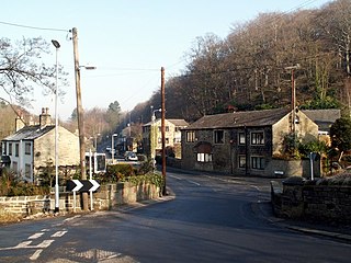
Thunder Bridge or Thunderbridge is a hamlet and bridge in the civil parish of Kirkburton, in the Kirklees district, in the county of West Yorkshire, England. It is near the A629 road and Stocksmoor railway station. Its post town is Huddersfield. It has a pub called the Woodman Inn. The bridge is a Grade II listed building which is a road bridge over Shepley Dike. Thunder Bridge is a conservation area.
Kirkburton is a civil parish in the metropolitan borough of Kirklees, West Yorkshire, England. It contains 164 listed buildings that are recorded in the National Heritage List for England. Of these, two are listed at Grade I, the highest of the three grades, two are at Grade II*, the middle grade, and the others are at Grade II, the lowest grade. The list also includes two listed buildings outside the parish but in Kirkburton ward; both of these are at Grade II. There are no major towns in the parish, but it contains villages and smaller settlements including Farnley Tyas, Flockton, Flockton Green, Grange Moor, Highburton, Kirkheaton, Lepton, Shelley, Shepley, Stocksmoor, Thunder Bridge, and Thurstonland. The parish is otherwise rural.
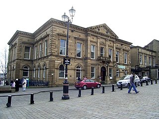
Batley Town Hall is a municipal facility in the Market Place in Batley, West Yorkshire, England. It is a Grade II listed building.

Meltham Town Hall is a municipal building in Carlile Street in Meltham, West Yorkshire, England. The building, which formerly operated as the offices of Meltham Urban District Council, is now The Crossroads Centre, which operates the local foodbank.


