Knowles Mill

Last updated
Knowles Mill
Knowles Mill 003.jpg
Knowles Mill
LocationBewdley, Worcestershire, England
Coordinates 52°23′12″N2°21′03″W / 52.3868°N 2.3508°W / 52.3868; -2.3508
TypeRuined mill
OwnerNational Trust
Nearest parking34 mi (1,200 m) from site
Website www.nationaltrust.org.uk/knowles-mill

Knowles Mill is the remains of an eighteenth-century water-powered grain mill, located in the Wyre Forest in Worcestershire, England. The mill has been owned by the National Trust since 1938. The mill and its surroundings feature extant machinery, as well as notable populations of adders and wood cranesbill.

Contents

Background

Knowles Mill is a Grade II listed water-powered grain mill, located on Dowles Brook, in the Wyre Forest, Bewdley, Worcestershire. [1] [2] [3] The forest is the UK's largest National Nature Reserve and is administered by Forestry England, Worcestershire Wildlife Trust and Natural England. [4] [3] However the mill, as well as the mill pond, meadow, cottage and gardens are National Trust property. [3]

The mill is approximately 34 mi (1,200 m) from the nearest parking lot. [5] The path to the mill roughly follows Dowles Brook stream. [6] The site also includes Knowles Mill Cottage, which is not accessible to the public. [7] The woodland Knowles Coppice surrounds the mill to the south. [8]

History

One of nine possible mills that historically worked on Dowles Brook, Knowles Mill was built in the eighteenth century, and was later modified in the nineteenth century. [9] The surviving building is two storeys high and the site also preserves an overshot mill wheel made of iron and a great spur wheel, alongside other remnant machinery. [1] The first record of a mill on the site dates to 1757 when it was listed as for sale in a local newspaper. [9] However there is documentary evidence preceding 1757 that lists owners of the land that the mill was built on. These owners include Arthur Palmer, c.1661, Edward Wheeler, c.1693, Roger Hunt, c.1704, Antony Betts, c.1717, Edward Faulkner, c.1722 and Daniel Crun, c.1735. [3]

The first owner of the mill was William Crun, in 1757. It passed through a number of owners, including William and Mary Herbert, William Nicholls and Arthur Nott. [3] The mill takes its name from the Knowles family who worked there from 1803 to the 1870s; earlier names included Coventry Mill and Upper Town Mill. [10] The first member of the family to be listed as owner was James Knowles. [3] The mill continued in use until 1891, when it became no longer financially viable. [10]

It was donated to the National Trust by Paul Cadbury in 1938, along with four acres of orchards. [11] [12] [5] The property was visited by the historian James Lees-Milne during his work as a curator for the Trust. [13]

Archaeology

In 2010 Birmingham Archaeology investigated the site and found the remains of a cast iron mill wheel, as well as "remains of the head race culvert"; other trenches investigated water flow and the mill race. [9] [3] Artefacts from the excavations included a 17th-century yellowware pancheon bowl, a Sankey flowerpot, two shards of 18th-century green glass, an early 20th-century pocket-watch and a blue poison bottle inscribed "NOT TO BE TAKEN" from the wheel pit. [3] There were 149 bottles or fragments of glass excavated from the site, representing brands such as Gartons HP Sauce, Bovril, Kidderminster Brewery, White Horse Distillers, Watville Dairies and Venos cough medicine. [3]

Conservation

Since 1982, climatological measurements have been made at Knowles Mill and have been recorded and analysed at the University of Birmingham. [14] The area surrounding the mill is notable for its adder populations, [14] and for the presence of wood cranesbill. [15]

See also

Related Research Articles

<span class="mw-page-title-main">Worcestershire</span> County of England

Worcestershire is a ceremonial county in the West Midlands of England. It is bordered by Shropshire, Staffordshire, and the West Midlands county to the north, Warwickshire to the east, Gloucestershire to the south, and Herefordshire to the west. The city of Worcester is the largest settlement and the county town.

<span class="mw-page-title-main">Kidderminster</span> Human settlement in England

Kidderminster is a market and historic minster town and civil parish in Worcestershire, England, 20 miles (32 km) south-west of Birmingham and 12 miles (19 km) north of Worcester. Located north of the River Stour and east of the River Severn, in the 2021 census, it had a population of 57,400. The town is twinned with Husum, Germany.

<span class="mw-page-title-main">Bewdley</span> Human settlement in England

Bewdley is a town and civil parish in the Wyre Forest District in Worcestershire, England on the banks of the River Severn. It is in the Severn Valley, and is 3 miles (4.8 km) west of Kidderminster, 10 miles (16 km) North of Worcester and 25 miles (40 km) southwest of Birmingham. It lies on the River Severn, at the gateway of the Wyre Forest national nature reserve, and at the time of the 2011 census had a population of 9,470. Bewdley is a popular tourist destination and is known for the Bewdley Bridge, designed by Thomas Telford, and the well preserved Georgian riverside.

<span class="mw-page-title-main">Wyre Forest</span> Large, semi-natural woodland in England

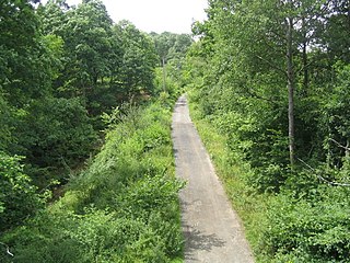
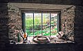
Wyre Forest is a large, semi-natural woodland and forest measuring 26.34 square kilometres (10.17 sq mi) which straddles the borders of Worcestershire and Shropshire, England. Knowles Mill, a former corn mill owned by the National Trust, lies within the forest.

<span class="mw-page-title-main">A456 road</span> Road in the West Midlands

Known as the Hagley Road in Birmingham, the A456 is a main road in England running between Central Birmingham and Woofferton, Shropshire, south of Ludlow. Some sections of the route, for example Edgbaston near Bearwood, are also the route of the Elan Aqueduct which carries Birmingham's water supply from the Elan Valley.

<span class="mw-page-title-main">Blakedown</span> Human settlement in England

Blakedown is a village in the Wyre Forest District lying along the A456 in the north of the county of Worcestershire, England. Following enclosures and the arrival of the railway, it developed both agriculturally and industrially during the 19th century. Due to its transport links, it now serves mainly as a dormitory for the neighbouring town of Kidderminster and for the cities of Birmingham and Worcester.

<span class="mw-page-title-main">Chaddesley Corbett</span> Human settlement in England

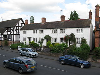
Chaddesley Corbett is a village and civil parish in the Wyre Forest District of Worcestershire, England. The Anglican and secular versions of the parish include other named neighbourhoods, once farmsteads or milling places: Bluntington, Brockencote, Mustow Green, Cakebole, Outwood, Harvington, and Drayton.

<span class="mw-page-title-main">Wyre Forest District</span> Non-metropolitan district in England

Wyre Forest is a local government district in Worcestershire, England. It is named after the ancient woodland of Wyre Forest. The largest town is Kidderminster, where the council is based. The district also includes the towns of Stourport-on-Severn and Bewdley, along with several villages and surrounding rural areas.

<span class="mw-page-title-main">Bewdley railway station</span> Station in Worcestershire, England

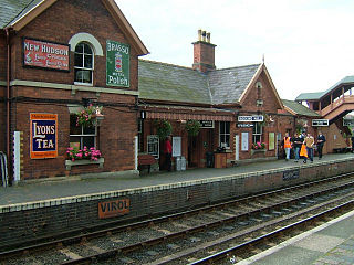
Bewdley railway station serves the town of Bewdley in Worcestershire, England. Until 2014, it was the administrative headquarters of the Severn Valley Railway, after which they were moved to Comberton Hill, Kidderminster. Bewdley is the principal intermediate station on the line.

<span class="mw-page-title-main">Wolverley</span> Human settlement in England

Wolverley is a village; with nearby Cookley, it forms a civil parish in the Wyre Forest District of Worcestershire, England. It is 2 miles north of Kidderminster and lies on the River Stour and the Staffordshire and Worcestershire Canal. At the time of the 2001 census, it had a population of 2,096.

The Bewdley School is a senior school and sixth form in Bewdley, serving north-west Worcestershire, England. Its campus is very close to the River Severn and lies on the border of the Wyre Forest national nature reserve. Bewdley is an educational research partner of the University of Worcester and University of Birmingham and is recognised for its focus on international and cultural education. In 2019, Bewdley hosted the Global Happiness Conference in partnership with the British Council. The Bewdley School has close ties with the nearby Bewdley Rowing Club established in 1877.

Birmingham Archaeology was the commercial arm of the Institute of Archaeology and Antiquity at the University of Birmingham. Birmingham University Field Archaeology Unit was founded in 1976 under its founder-director Martin Carver. Birmingham Archaeology closed down in 2012.

<span class="mw-page-title-main">2004 Wyre Forest District Council election</span> Election in Worcestershire, England

The 2004 Wyre Forest District Council election took place on 10 June 2004 to elect members of Wyre Forest District Council in Worcestershire, England. The whole council was up for election with boundary changes since the last election in 2003. The council stayed under no overall control, but with the Conservatives taking over as the largest party on the council from the Health Concern party.

<span class="mw-page-title-main">Yellowware</span> Type of earthenware

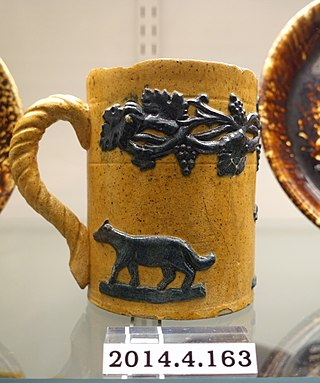
Yellowware, or yellow ware, is a type of earthenware named after its yellow appearance given to it by the clay used for its production. Originating in the United Kingdom in the late 18th century, it was also produced in the eastern United States from the late 1820s.

<span class="mw-page-title-main">Dowles Brook</span> Stream in Shropshire and Worcestershire, England

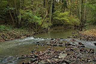
Dowles Brook flows through the heart of the Wyre Forest, into the former civil parish of Dowles and into the River Severn.

Jannion Steele Elliott, his surname sometimes hyphenated to Steele-Elliott, was a British ornithologist and naturalist who, in particular, accumulated large amounts of information on the mammals and birds of Bedfordshire.

<span class="mw-page-title-main">Ribbesford House</span> Mansion in Worcestershire, England


Ribbesford House is a historic English mansion in Ribbesford, near Bewdley, Worcestershire. The house and its surrounding estate have a history dating back nearly a thousand years. The current house is a Grade II* listed building which has architectural elements ranging from the 16th to the 19th century.

<span class="mw-page-title-main">Bewdley Guildhall</span> Municipal building in Bewdley, Worcestershire, England

Bewdley Guildhall is a municipal building in Load Street in Bewdley, Worcestershire, England. The structure, which is the meeting place of Bewdley Town Council, is a Grade II* listed building.

<span class="mw-page-title-main">Dowles</span> Human settlement in England

Dowles is a hamlet in the civil parish of Upper Arley, in the Wyre Forest district, in the county of Worcestershire, England. It is about 3 miles from the town of Kidderminster. The parish was divided into two parts by the Severn.

References

  1. 1 2 Historic England. "Knowles Mill (Grade II) (1166692)". National Heritage List for England . Retrieved 31 July 2022.
  2. Cherry, John (1 January 1972). "Post-Medieval Britain in 1971". Post-Medieval Archaeology. 6 (1): 208–223. doi:10.1179/pma.1972.014. ISSN   0079-4236 . Retrieved 31 July 2022.
  3. 1 2 3 4 5 6 7 8 9 Halsted, Jon; Hewitson, Chris; Booth, Tim (2010). Knowles Mill, Wyre Forest, Bewdley, Worcestershire - Historic Building Recording, Archaeological Evaluation. Birmingham: Birmingham Archaeology. pp. 14–22.
  4. "Wyre Forest". Forestry England. Archived from the original on 26 July 2022. Retrieved 26 July 2022.
  5. 1 2 "Knowles Mill". spab.org.uk. Archived from the original on 17 October 2021. Retrieved 26 July 2022.
  6. Boston, Irene (1999). Best Tea Shop Walks in Worcestershire. Sigma Leisure. ISBN   978-1-85058-646-3. Archived from the original on 2022-08-11. Retrieved 2022-07-27.
  7. Historic England. "Knowles Mill Cottage (Grade II) (1100006)". National Heritage List for England . Retrieved 31 July 2022.
  8. "Knowles Coppice | Worcestershire Wildlife Trust". www.worcswildlifetrust.co.uk. Archived from the original on 26 July 2022. Retrieved 26 July 2022.
  9. 1 2 3 "MNA142413 National Trust Heritage Records". heritagerecords.nationaltrust.org.uk. Retrieved 26 July 2022.
  10. 1 2 Booth, Tim (2010). "Mills on Dowles Brook" (PDF). Wyre Forest Study Group Annual Review: 10. Archived (PDF) from the original on 8 March 2022. Retrieved 31 July 2022.
  11. Matheson, Donald Macleod (1950). Places of Natural Beauty: National Trust Guide. Batsford. p. 66.
  12. Airs, Malcolm (2002). The Twentieth Century Great House. Department for Continuing Education, Oxford University. p. 88. ISBN   978-0-903736-31-2.
  13. Lees-Milne, James; Bloch, Michael (2011). Diaries, 1942-1954. John Murray Press. ISBN   978-1-84854-709-4. Archived from the original on 2022-08-11. Retrieved 2022-07-27.
  14. 1 2 Sheldon, Sylvia (2011). "Wyre Forest Adder Census and Report 1999 and Adder Population Trends through the 1990s - Correlated with Meteorological Data" (PDF). Wyre Valley Study Group Annual Review: 35–39. Archived (PDF) from the original on 19 June 2022. Retrieved 31 July 2022.
  15. Bingham, John (2003). "Uncommon Plant Species found within the Wyre Forest" (PDF). Wyre Forest Study Group Annual Review. Archived (PDF) from the original on 8 January 2022. Retrieved 31 July 2022.