The Missoula floods were cataclysmic glacial lake outburst floods that swept periodically across eastern Washington and down the Columbia River Gorge at the end of the last ice age. These floods were the result of periodic sudden ruptures of the ice dam on the Clark Fork River that created Glacial Lake Missoula. After each ice dam rupture, the waters of the lake would rush down the Clark Fork and the Columbia River, flooding much of eastern Washington and the Willamette Valley in western Oregon. After the lake drained, the ice would reform, creating Glacial Lake Missoula again.

Lake Missoula was a prehistoric proglacial lake in western Montana that existed periodically at the end of the last ice age between 15,000 and 13,000 years ago. The lake measured about 7,770 square kilometres (3,000 sq mi) and contained about 2,100 cubic kilometres (500 cu mi) of water, half the volume of Lake Michigan.

Grand Coulee is an ancient river bed in the U.S. state of Washington. This National Natural Landmark stretches for about 60 miles (100 km) southwest from Grand Coulee Dam to Soap Lake, being bisected by Dry Falls into the Upper and Lower Grand Coulee.

The Channeled Scablands are a relatively barren and soil-free region of interconnected relict and dry flood channels, coulees and cataracts eroded into Palouse loess and the typically flat-lying basalt flows that remain after cataclysmic floods within the southeastern part of Washington state. The Channeled Scablands were scoured by more than 40 cataclysmic floods during the Last Glacial Maximum and innumerable older cataclysmic floods over the last two million years. These floods were periodically unleashed whenever a large glacial lake broke through its ice dam and swept across eastern Washington and down the Columbia River Plateau during the Pleistocene epoch. The last of the cataclysmic floods occurred between 18,200 and 14,000 years ago.

The Palouse River is a tributary of the Snake River in Washington and Idaho, in the northwest United States. It flows for 167 miles (269 km) southwestwards, primarily through the Palouse region of southeastern Washington. It is part of the Columbia River Basin, as the Snake River is a tributary of the Columbia River.
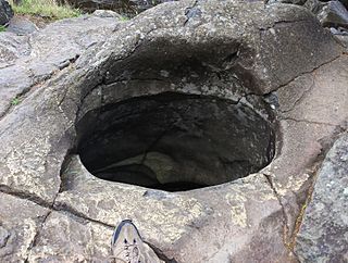
A giant's kettle, also known as either a giant's cauldron, moulin pothole, or glacial pothole, is a typically large and cylindrical pothole drilled in solid rock underlying a glacier either by water descending down a deep moulin or by gravel rotating in the bed of subglacial meltwater stream.

A plunge pool is a deep depression in a stream bed at the base of a waterfall or shut-in. It is created by the erosional forces of cascading water on the rocks at the formation's base where the water impacts. The term may refer to the water occupying the depression, or the depression itself.

The Touchet Formation or Touchet beds consist of well-bedded, coarse to fine sand and silt which overlays local bedrock composed of Neogene basalt of the Columbia River Basalt Group in south-central Washington and north-central Oregon. The beds consist of more than 40 to 62 distinct rhythmites – horizontal layers of sediment, each clearly demarcated from the layer below. These Touchet beds are often covered by windblown loess which were deposited later; the number of layers varies with location. The beds vary in thickness from 330 ft (100 m) at lower elevations where a number of layers can be found to a few extremely thin layers at the maximum elevation where they are observed.

Lake Lewis was a large transient lake in the Pacific Northwest region of North America, formed by periodic Missoula Floods along the Columbia River paleocourse between 21,000 and 16,000 years ago.
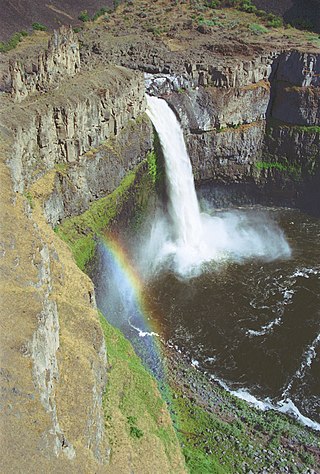
Palouse Falls is a waterfall in the northwest United States on the Palouse River, about four miles (6 km) upstream of its confluence with the Snake River in southeast Washington. Within the 94-acre (38 ha) Palouse Falls State Park, the falls are 200 feet (61 m) in height, and consist of an upper fall with a drop around twenty feet (6 m), which lies 1,000 feet (300 m) north-northwest of the main drop, and a lower fall.
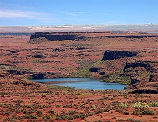
Drumheller Channels National Natural Landmark showcases the Drumheller Channels, which are the most significant example in the Columbia Plateau of basalt butte-and-basin Channeled Scablands. This National Natural Landmark is an extensively eroded landscape, located in south central Washington state characterized by hundreds of isolated, steep-sided hills (buttes) surrounded by a braided network of numerous channels, all but one of which are currently dry. It is a classic example of the tremendous erosive powers of extremely large floods such as those that reformed the Columbia Plateau volcanic terrain during the late Pleistocene glacial Missoula Floods.

Moses Coulee is a canyon in the Waterville plateau region of Douglas County, Washington. Moses Coulee is the second-largest and westernmost canyon of the Channeled Scablands, located about 30 kilometres (19 mi) to the west of the larger Grand Coulee. This water channel is now dry, but during glacial periods, large outburst floods with discharges greater than 600,000 m3/s (21,000,000 cu ft/s) carved the channel. While it's clear that glacial floodwaters passed through and contributed to the erosion of Moses Coulee, the age of those waters, thus the origins of the coulee are less clear. No clear connection between the head of the coulee and major flood routes to the north, east, or west is known. Some researchers propose that floods from glacial Lake Missoula formed Moses Coulee, while others suggest that subglacial floods from the Okanogan Lobe incised the canyon. The mouth of Moses Coulee discharges into the Columbia River.

Crab Creek is a stream in the U.S. state of Washington. Named for the presence of crayfish, it is one of the few perennial streams in the Columbia Basin of central Washington, flowing from the northeastern Columbia River Plateau, roughly 5 km (3.1 mi) east of Reardan, west-southwest to empty into the Columbia River near the small town of Beverly. Its course exhibits many examples of the erosive powers of extremely large glacial Missoula Floods of the late Pleistocene, which scoured the region. In addition, Crab Creek and its region have been transformed by the large-scale irrigation of the Bureau of Reclamation's Columbia Basin Project (CBP), which has raised water table levels, significantly extending the length of Crab Creek and created new lakes and streams.

The Columbia Plateau State Park Trail is a 130-mile-long (210 km), 20-foot-wide (6.1 m) corridor in eastern Washington state maintained as part of the Washington State Park system. The rail trail runs along the abandoned right-of-way of the former Spokane, Portland and Seattle Railway.

The Columbia Plateau ecoregion is a Level III ecoregion designated by the United States Environmental Protection Agency (EPA) encompassing approximately 32,100 square miles (83,139 km2) of land within the U.S. states of Washington, Oregon, and Idaho. The ecoregion extends across a wide swath of the Columbia River Basin from The Dalles, Oregon to Lewiston, Idaho to Okanogan, Washington near the Canada–U.S. border. It includes nearly 500 miles (800 km) of the Columbia River, as well as the lower reaches of major tributaries such as the Snake and Yakima rivers and the associated drainage basins. It is named for the Columbia Plateau, a flood basalt plateau formed by the Columbia River Basalt Group during the late Miocene and early Pliocene. The arid sagebrush steppe and grasslands of the region are flanked by moister, predominantly forested, mountainous ecoregions on all sides. The underlying basalt is up to 2 miles (3 km) thick and partially covered by thick loess deposits. Where precipitation amounts are sufficient, the deep loess soils have been extensively cultivated for wheat. Water from the Columbia River is subject to resource allocation debates involving fisheries, navigation, hydropower, recreation, and irrigation, and the Columbia Basin Project has dramatically converted much of the region to agricultural use.
The Ice Age Floods National Geologic Trail is a network of routes connecting natural sites and facilities that provide interpretation of the geological consequences of the Glacial Lake Missoula floods of the last glacial period that occurred about 18,000 to 15,000 years ago. It includes sites in Washington, Oregon, Idaho, and Montana. It was designated as the first National Geologic Trail in the United States in 2009.

The Bonneville flood was a catastrophic flooding event in the last ice age, which involved massive amounts of water inundating parts of southern Idaho and eastern Washington along the course of the Snake River. Unlike the Missoula Floods, which also occurred during the same period in the Pacific Northwest, the Bonneville flood happened only once. It is believed to be the second-largest flood in known geologic history.
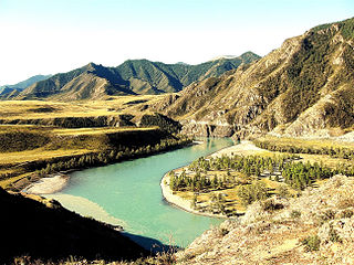
The Altai flood refers to the cataclysmic flood(s) that, according to some geomorphologists, swept along the Katun River in the Altai Republic at the end of the last ice age. These glacial lake outburst floods were the result of periodic sudden ruptures of ice dams like those triggering the Missoula floods.
Rock Creek is a tributary of the Palouse River in the U.S. state of Washington. The source of the creek is Pine Lakes in the Turnbull National Wildlife Refuge (TNWR). The creek flows through the TNWR and ultimately joins the Palouse River 6 miles (10 km) downstream from the unincorporated town of Winona, Washington.
A pendant bar is a large, streamlined, fluvial bar that is typically composed of gravel which occurs just downstream of a bedrock obstruction within a river channel or floodway that has been scoured by either an outburst flood, megaflood, or jökulhlaup. They are often associated with giant current ripples. Malde introduced this to refer to streamlined mounds of gravel deposited by the Bonneville Flood that lie downstream of bedrock projections on the scoured valley floor of the Snake River. They are most common type of bar found within the Channeled Scablands created by the Missoula floods. The obstruction for the initiation of pendant bars in the Channeled Scablands is typically either a knob of basalt or the relict bend of a pre-flood meandering valley.