
Dynamic positioning (DP) is a computer-controlled system to automatically maintain a vessel's position and heading by using its own propellers and thrusters. Position reference sensors, combined with wind sensors, motion sensors and gyrocompasses, provide information to the computer pertaining to the vessel's position and the magnitude and direction of environmental forces affecting its position. Examples of vessel types that employ DP include ships and semi-submersible mobile offshore drilling units (MODU), oceanographic research vessels, cable layer ships and cruise ships.

Kongsberg Gruppen is a Norwegian multinational company, that supplies high-technology systems to customers in the merchant marine, defence, aerospace, offshore oil and gas industries, and renewable and utilities industries.

A remotely operated underwater vehicle (ROUV) or remotely operated vehicle (ROV) is a free-swimming submersible craft used to perform underwater observation, inspection and physical tasks such as valve operations, hydraulic functions and other general tasks within the subsea oil and gas industry, military, scientific and other applications. ROVs can also carry tooling packages for undertaking specific tasks such as pull-in and connection of flexible flowlines and umbilicals, and component replacement. They are often used to visit wrecks at great depths beyond the capacities of submersibles for research purposes, such as the Titanic, amongst others.

An autonomous underwater vehicle (AUV) is a robot that travels underwater without requiring continuous input from an operator. AUVs constitute part of a larger group of undersea systems known as unmanned underwater vehicles, a classification that includes non-autonomous remotely operated underwater vehicles (ROVs) – controlled and powered from the surface by an operator/pilot via an umbilical or using remote control. In military applications an AUV is more often referred to as an unmanned undersea vehicle (UUV). Underwater gliders are a subclass of AUVs.
Kongsberg Mesotech Ltd, based in Port Coquitlam, BC, Canada, is informally operated by Kongsberg Gruppen. Website Proff.no does not include the company on the lists of subsidiaries of Kongsberg Gruppen or Kongsberg Maritime.
Underwater Port Security System (UPSS) was developed for the United States Coast Guard and the Maritime Safety and Security Teams (MSSTs) for defense against swimmer incursions. It includes the Underwater Inspection System (UIS) and the Integrated Anti-Swimmer System (IAS). Recent developments in terrorism have highlighted the need for underwater anti-frogman security. The UPSS is made in the United States and is reported to be compact enough fit in a large suitcase.

Marine engineering is the engineering of boats, ships, submarines, and any other marine vessel. Here it is also taken to include the engineering of other ocean systems and structures – referred to in certain academic and professional circles as "ocean engineering". After completing this degree one can join a ship as an officer in engine department and eventually rise to the rank of a chief engineer. This rank is one of the top ranks onboard and is equal to the rank of a ship's captain. Marine engineering is the highly preferred course to join merchant Navy as an officer as it provides ample opportunities in terms of both onboard and onshore jobs.
A navigation system is a computing system that aids in navigation. Navigation systems may be entirely on board the vehicle or vessel that the system is controlling or located elsewhere, making use of radio or other signal transmission to control the vehicle or vessel. In some cases, a combination of these methods is used.

A multibeam echosounder (MBES) is a type of sonar that is used to map the seabed. It emits acoustic waves in a fan shape beneath its transceiver. The time it takes for the sound waves to reflect off the seabed and return to the receiver is used to calculate the water depth. Unlike other sonars and echo sounders, MBES uses beamforming to extract directional information from the returning soundwaves, producing a swathe of depth soundings from a single ping.
Subsea technology involves fully submerged ocean equipment, operations, or applications, especially when some distance offshore, in deep ocean waters, or on the seabed. The term subsea is frequently used in connection with oceanography, marine or ocean engineering, ocean exploration, remotely operated vehicle (ROVs) autonomous underwater vehicles (AUVs), submarine communications or power cables, seafloor mineral mining, oil and gas, and offshore wind power.

Robot localization denotes the robot's ability to establish its own position and orientation within the frame of reference. Path planning is effectively an extension of localization, in that it requires the determination of the robot's current position and a position of a goal location, both within the same frame of reference or coordinates. Map building can be in the shape of a metric map or any notation describing locations in the robot frame of reference.
Diver detection sonar (DDS) systems are sonar and acoustic location systems employed underwater for the detection of divers and submerged swimmer delivery vehicles (SDVs). The purpose of this type of sonar system is to provide detection, tracking and classification information on underwater threats that could endanger property and lives. Further, this information is useful only to the extent that it is made available to authorities in time to make possible the desired response to the threat, be it deterrent or defensive action. Subsurface threats are a difficult problem, because reliable detection is available to date chiefly by use of high-resolution active sonar or trained dolphins or sea lions. The threat of an underwater terrorist attack is a concern to the maritime industry and port law enforcement agencies. Ports face a range of threats from swimmers, boat-delivered ordnance such as limpet mines and other forms of improvised underwater explosive devices. DDS systems have been developed to provide underwater security for ports, coastal facilities, offshore installations, pipelines and ships. Due to the variety of life and objects that exist under the water, it is desirable that a DDS system be capable of distinguishing between large sea mammals, shoals of fish; a ship's wake; a diver with an open circuit scuba set and a stealth diver with a rebreather. DDS systems have been developed that can be mounted on the seabed, on a pier or on the hull of a vessel. For complete port security these systems are integrated with the surface surveillance and security systems employed at ports, coastal facilities and offshore installations. Various systems provide specialized features to facilitate their use in port security systems including automatic detection features.
An underwater acoustic positioning system is a system for the tracking and navigation of underwater vehicles or divers by means of acoustic distance and/or direction measurements, and subsequent position triangulation. Underwater acoustic positioning systems are commonly used in a wide variety of underwater work, including oil and gas exploration, ocean sciences, salvage operations, marine archaeology, law enforcement and military activities.

Marine technology is defined by WEGEMT as "technologies for the safe use, exploitation, protection of, and intervention in, the marine environment." In this regard, according to WEGEMT, the technologies involved in marine technology are the following: naval architecture, marine engineering, ship design, ship building and ship operations; oil and gas exploration, exploitation, and production; hydrodynamics, navigation, sea surface and sub-surface support, underwater technology and engineering; marine resources ; transport logistics and economics; inland, coastal, short sea and deep sea shipping; protection of the marine environment; leisure and safety.

The REMUS series are autonomous underwater vehicles (AUVs) made by the Woods Hole Oceanographic Institution and designed by their Oceanographic Systems Lab (OSL). More recently REMUS vehicles have been manufactured by the spinoff company Hydroid Inc, which was a wholly owned subsidiary of Kongsberg Maritime. Hydroid was acquired by Huntington Ingalls Industries (HHI) in March 2020. The series are designed to be low cost, they have shared control software and electronic subsystems and can be operated from a laptop computer. They are used by civilians for seafloor mapping, underwater surveying, and search and recovery as well as by several navies for mine countermeasures missions.
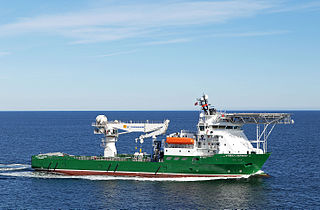
The MV Havila Harmony is a multi-role, dynamically-positioned support vessel built in 2005 for subsea construction and support operations. The vessel is owned by Havila Shipping and currently on long-term charter to Fugro.
The Eelume is an autonomous underwater vehicle being developed by Eelume AS, in partnership with Kongsberg Maritime and Equinor.

Autonomous cargo ships, also known as autonomous container ships or maritime autonomous surface ships (MASS), are crewless vessels that transport either containers or bulk cargo over navigable waters with little or no human interaction. Different methods and levels of autonomy can be achieved through monitoring and remote control from a nearby manned ship, an onshore control center or through artificial intelligence and machine learning, letting the vessel itself decide the course of action.
USV Maxlimer is a semi-autonomous, remotely controlled unmanned surface vehicle (USV) owned and operated by the British company SEA-KIT International. She was the winning entry in the Shell Ocean Discovery X Prize competition, and subsequently has been used as a proof-of-concept vessel for uncrewed, over-the-horizon offshore operations.

RFA Proteus is a ship of the Royal Fleet Auxiliary within His Majesty's Naval Service of the United Kingdom. Its roles being a platform for Remotely Operated Underwater Vehicles (ROUVs) and a testbed for new specialist capabilities, required for monitoring waters important to UK interests. Acquired in 2023, the ship entered drydock at Cammell Laird for modification into a Multi-Role Ocean Surveillance Ship (MROSS). She formally entered service in October 2023.
