Kovur, Nellore district

Last updated

Kovur
Kovuru
village
kovur
Sri Nagavarapamma temple, Kovur.jpg
Sri Nagavarapamma temple, Kovur
India Andhra Pradesh location map (current).svg
Red pog.svg
Kovur
Location of kovur in Andhra Pradesh, India
Coordinates: 14°30′00″N79°59′09″E / 14.5001°N 79.9859°E / 14.5001; 79.9859
Country India
State Andhra Pradesh
District Nellore
small town Kovur
Government
  Body Nellore Urban Development Authority
  DirectorKutla Uma (Telugu Desam party)
  NUDA ChairmanKotamreddy Sreenivasulu reddy
Area
[1]
  village6.28 km2 (2.42 sq mi)
Elevation
[2]
19 m (62 ft)
Population
 (2011) [3]
  village32,082 [3]
   Urban
32,082 [3]
Languages
  Official Telugu
Time zone UTC+5:30 (IST)
PIN
524137
Assembly constituency number225
Vehicle registration AP 26
Website Kovur Official website
This is the image of kovur entrance at Saluchintal Center, Kovur at NH-67 Kovur Board On Newly Constructed NH-67.jpg
This is the image of kovur entrance at Saluchintal Center, Kovur at NH-67
Kovur Trunk Road. Kovur Trunk Road.jpg
Kovur Trunk Road.

Kovur is a village in Nellore district of the Indian state of Andhra Pradesh. The village is also the headquarters of the Kovur Mandal and Assembly Constituency. It is located in Kovur mandal of Nellore revenue division. [4] It forms a part of Nellore Urban Development Authority. [5] The poet "Thikkanna" was born in this place.

Contents

Geography

Kovur is located at 14°30′00″N79°59′09″E / 14.5001°N 79.9859°E / 14.5001; 79.9859 and at an altitude of 19 m (62 ft). [2] The village is spread over an area of 6.28 km2 (2.42 sq mi). [1] Penna River is the major river flows in the proximity of the village. [6]

Demographics

As of 2011 census, Kovur had a population of 32,082. The total population constitute, 15,640 males and 16,442 females —a sex ratio of 1,051 females per 1,000 males. 3,196 children are in the age group of 0–6 years, of which 1,659 are boys and 1,537 are girls. The average literacy rate stands at 74.45% with 21,506 literates, significantly higher than the state average of 67.41%. [1] [7]

Government and politics

Kovur gram panchayat is the local self-government of the village. [8] [9] The panchayat has a total of 20 wards with an elected ward member. The present sarpanch of the village is Kutla Uma and vice-sarpanch is Intha Malla Reddy. [10] Kovur in Kovur mandal is represented by Kovur assembly constituency of Andhra Pradesh Legislative Assembly. [11] The present MLA representing the constituency is Prasanna kumar Reddy of YSR Congress. [12] It forms a part in Nellore Urban Development Authority. The present chairman is Kotamreddy Sreenivasulu reddy.

Economy

Paddy (unboiled rice) sugarcane is the major Agricultural crop produced. [13] The L.Vannamei variety of Shrimp farming is the major Aquaculture production in and around Kovur. [14]

Transport

National Highway 16, a part of Golden Quadrilateral project, bypasses Kovur village. [15] Padugupadu railway station provides rail connectivity and is situated on Vijayawada-Gudur section of Howrah-Chennai main line. [16] It is administered under Vijayawada railway division of South Central Railway zone. [17] National Highway 67 bypasses through Kovur village.

Notable Persons

Education

The primary and secondary school education is imparted by government, aided and private schools, under the School Education Department of the state. [18] [19] The total number of students enrolled in primary, upper primary and high schools of the village are 1,731. [20] There are 15 schools which include, six private, eight Mandal Parishad and ZPHS, and other types of school as well. [21] [22]

Related Research Articles

<span class="mw-page-title-main">Nellore</span> City in Andhra Pradesh, India

Nellore is a city located on the banks of Penna River, in Nellore district of the Indian state of Andhra Pradesh. It serves as the headquarters of the district, as well as Nellore mandal and Nellore revenue division. It is the fourth most populous city in the state. It is at a distance of 700 km from Visakhapatnam and about 170 km north of Chennai, Tamil Nadu and also about 380 km east-northeast of Bangalore, Karnataka.

<span class="mw-page-title-main">Chittoor</span> City in Andhra Pradesh, India

Chittoor is a city and district headquarters in Chittoor district of the Indian state of Andhra Pradesh. It is also the mandal and divisional headquarters of Chittoor mandal and Chittoor revenue division respectively. The city has a population of 153,756 and that of the agglomeration is 175,647.

<span class="mw-page-title-main">Ongole</span> City in Andhra Pradesh, India

Ongole is a city in Prakasam district of the Indian state of Andhra Pradesh. It is the headquarters of Prakasam district and also the mandal headquarters of Ongole mandal in Ongole revenue division. Ongole cattle, an indigenous breed of oxen, derived their name from Ongole.

<span class="mw-page-title-main">Kurnool district</span> District of Andhra Pradesh, India

Kurnool district is one of the eight districts in the Rayalaseema region of the Indian state of Andhra Pradesh after the districts are reorganised in April 2022. It is located in the north western part of the state and is bounded by Nandyal district in the east, Anantapur district in the south, Raichur district of Karnataka in the northwest, Bellary district of Karnataka in the west, and Jogulamba Gadwal district of Telangana in the north. It has a population of 2,271,686 based on the 2011 census. The city of Kurnool is the headquarters of the district.

<span class="mw-page-title-main">Nellore district</span> District of Andhra Pradesh in India

Nellore district, officially known as Sri Potti Sriramulu Nellore district or simply SPS Nellore district in Coastal Andhra Region, is one of the 26 districts in the Indian state of Andhra Pradesh. According to the 2011 Census, the district's population was 2,469,712 of which 29.07% was urban. Its administrative headquarters are located in Nellore city. Located in the Coastal Andhra region, the district is bordered by the Bay of Bengal to the east, Kadapa district and Annamayya district to the west, Prakasam district to the north, and Tirupati district to the south.

<span class="mw-page-title-main">Prakasam district</span> District of Andhra Pradesh in India

Prakasamdistrict is one of the twelve districts in the coastal Andhra region of the Indian state of Andhra Pradesh. It was formed in 1970 and reorganised on 4 April 2022. The headquarters of the district is Ongole. It is located on the western shore of Bay of Bengal and is bounded by Bapatla district and Palnadu districts in the north, Nandyal district in the west, Kadapa and Nellore districts in the south. A part of north west region also borders with Nagarkurnool district of Telangana. It is the largest district in the state with an area of 14,322 km2 (5,530 sq mi) and had a population of 22,88,026 as per 2011 Census of India.Map

<span class="mw-page-title-main">Srikakulam district</span> District of Andhra Pradesh in India

Srikakulam district is one of the twenty-six districts of the Indian state of Andhra Pradesh, located in the Uttarandhra region of the state, with its headquarters located at Srikakulam. It is one of the six districts, located in the extreme northeastern direction of the state. It was formerly known as Chicacole, and was under Ganjam district till 1936 April 1, then merged under Vizagapatam district. Srikakulam district forms the core area of Kalinga where most of its historical capitals like Kalinganagari, pithunda, Dantapuram are located.

Rajampet is a Municipality in Annamayya district of the Indian state of Andhra Pradesh, located in the Rayalaseema Region formed on the banks of Cheyyeru River. The town has an average elevation of 139 meters (456 ft). Rajampet is a Grade II Municipality which upgraded in 2019 and has an area of 35.38 square kilometres (13.66 sq mi). It consists of 29 election wards.

<span class="mw-page-title-main">Allur, Nellore district</span> Town in Andhra Pradesh, India

Allur is a Town in Nellore district of the Indian state of Andhra Pradesh. It is the headquarters of Allur Mandal of Kavali revenue division.

Atmakur is a small town in Nellore district of the Indian state of Andhra Pradesh. It is a municipality in Atmakur mandal. The town is the headquarters of Atmakur mandal and Assembly Constituency.

Venkatagiri is a town in Tirupati district of the Indian state of Andhra Pradesh. It is a municipality and mandals headquarters of Venkatagiri mandal. Venkatagiri's old name is "Kali Mili". It is famous for its Handloom Cotton Sarees. Venkatagiri is a place for history and handlooms. It was part of a small kingdom that was integrated into the Indian Republic.

<span class="mw-page-title-main">Pakala, Tirupati district</span> Town in Andhra Pradesh, India

Pakala is a town in Tirupati district of the Indian state of Andhra Pradesh. It is the mandal headquarters of Pakala mandal. It comes under Tirupati revenue division.

<span class="mw-page-title-main">Duggirala</span> Village in Andhra Pradesh, India

Duggirala is a village in Guntur district of the Indian state of Andhra Pradesh. It is the mandal headquarters of Duggirala mandal in Tenali revenue division. It is one of the major turmeric trading centres in the country.

Vidavaluru is a village and a mandal headquarters in Nellore district in the state of Andhra Pradesh in india. It is located in Kovur.

<span class="mw-page-title-main">Podili</span> Town in Andhra Pradesh, India

Podili is a Municipality Town in Prakasam district of the Indian state of Andhra Pradesh. It is the mandal headquarters of Podili mandal. Podili is also known as Prudulapuri. Before British rule its name was "Prudulapuri" meaning "Head quarters of the universe". There is purana reference to this related to Prudhu Chakravarthi.

Ganikapudi Village in Andhra Pradesh, India

Ganikapudi is a village in Guntur district of the Indian state of Andhra Pradesh. It is located in Prathipadu mandal of Guntur revenue division.

<span class="mw-page-title-main">Kolakaluru</span> Neighborhood in Guntur, Andhra Pradesh, India

Kolakaluru is a neighborhood of Tenali city in Guntur district of the Indian state of Andhra Pradesh. It is located in Tenali mandal of Tenali revenue division. It forms a part of Andhra Pradesh Capital Region.

<span class="mw-page-title-main">Repalle mandal</span> Mandal in Andhra Pradesh, India

Repalle mandal is one of the 25 mandals in Bapatla district of the state of Andhra Pradesh, India. It is under the administration of Bapatla revenue division and the mandal headquarters are located at Repalle. The mandal is situated on the banks of Krishna River of Velanadu region and is bounded by Bhattiprolu, Nagaram and Nizampatnam mandals.

<span class="mw-page-title-main">Vemuru mandal</span> Mandal in Andhra Pradesh, India

Vemuru mandal is one of the 25 mandals in Bapatla district of the state of Andhra Pradesh in India. It is under the administration of Tenali Revenue Division and the headquarters are located at Vemuru. The mandal is bounded by Tenali, Kollipara and Kollur, Amruthalur, Cherukupalle and Bhattiprolu mandals. The mandal is also a part of the Andhra Pradesh Capital Region under the jurisdiction of APCRDA.

<span class="mw-page-title-main">Tirupati district</span> District in Andhra Pradesh, India

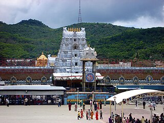
Tirupati district is one of the eight districts of Rayalaseema region in the Indian state of Andhra Pradesh. The district headquarters is located at Tirupati city. This district is known for its numerous historic temples, including the Hindu shrine of Tirumala Venkateswara Temple and Sri Kalahasteeswara temple. The district is also home to Satish Dhawan Space Centre, a rocket launch centre located in Sriharikota. The river Swarnamukhi flows through Tirupati, Srikalahasti and joins the Bay of Bengal.

References

  1. 1 2 3 "District Census Handbook – Nellore" (PDF). Census of India. The Registrar General & Census Commissioner. pp. 25, 295. Retrieved 19 June 2016.
  2. 1 2 "Maps, Weather, and Airports for Kovur, India". fallingrain.com.
  3. 1 2 3 Census ap.nic.in [ dead link ]
  4. "HandBook_2013-14_SPSNellore_final" (PDF). nellore.ap.nic.in. p. 77. Archived from the original (PDF) on 9 August 2017. Retrieved 1 July 2017.
  5. "Mandals and villages covered under Nellore UDA limits" (PDF). Directorate of village and Country Planning Andhra Pradesh. p. 4. Retrieved 30 June 2017.
  6. "Handbook 2013-14 SPS Nellore Final" (PDF). nellore.ap.nic.in. p. 2. Archived from the original (PDF) on 9 August 2017. Retrieved 30 June 2017.
  7. "Literacy of AP (Census 2011)" (PDF). Official Portal of Andhra Pradesh Government. p. 43. Archived from the original (PDF) on 14 July 2014. Retrieved 5 September 2014.
  8. "Kovur Village Panchayat". National Panchayat Portal. Retrieved 6 May 2016.
  9. "Gram Panchayat Identification Codes" (PDF). Saakshar Bharat Mission. p. 120. Archived from the original (PDF) on 5 July 2016. Retrieved 5 July 2016.
  10. "Elected Members of Kovur Gram Panchayat". www.nelkovurkovurgp.appr.gov.in. Retrieved 19 June 2017.
  11. "Delimitation of Parliamentary and Assembly Constituencies Order, 2008" (PDF). Election Commission of India. p. 23. Retrieved 11 October 2014.
  12. "Member's Report". Andhra Pradesh Legislature Assembly. Retrieved 12 October 2014.
  13. Staff, Government Of Madras; Madras, Government of (1942). Gazetteer of the Nellore District: Brought Upto 1938. Asian Educational Services. p. 3. ISBN   9788120618510 . Retrieved 30 June 2017.
  14. "Farmers incur losses as virus affecting shrimp production". The Hans India. Retrieved 30 June 2017.
  15. "Monthky Progress Report - July 2014" (PDF). nhai.org.in. p. 40. Retrieved 30 June 2017.
  16. "[IRFCA] Electrification History from CORE". irfca.org. Retrieved 30 June 2017.
  17. "Kolakalur railway station info". India Rail Info. Retrieved 30 July 2014.
  18. "School Education Department" (PDF). School Education Department, Government of Andhra Pradesh. Archived from the original (PDF) on 19 March 2016. Retrieved 12 April 2017.
  19. "The Department of School Education – Official AP State Government Portal | AP State Portal". www.ap.gov.in. Archived from the original on 13 April 2017. Retrieved 7 November 2016.
  20. "Student Information Report". Commissionerate of School Education. Child info 2015–16, District School Education – Andhra Pradesh. Retrieved 19 June 2017.
  21. "CSE". cse.ap.gov.in. Archived from the original on 8 November 2016. Retrieved 28 November 2016.
  22. "DSE - Department of School Education". cse.ap.gov.in. Retrieved 28 November 2016.