
Keta is a coastal town in the Volta Region of Ghana. It is the capital of the Keta Municipal District.
Ho is the capital of the Ho Municipal Assembly and the Volta Region of Ghana. The city lies between Mount Adaklu and Mount Galenukui or Togo Atakora Range, and is home to the Volta Regional Museum, a cathedral, and a prison. The city is the capital of unrecognised Western Togoland. It was formerly the administrative capital of British Togoland now part of the Volta Region. The population of Ho Municipality according to the 2010 Population and Housing Census is 177,281 representing 8.4 percent of the region's total population. Females constitute 52.7 percent and males represent 47.3 percent. The population in Ho grew up to 180,420 National Population Census. About 62 percent of the population resides in urban localities. The Municipality shares boundaries with Adaklu and Agotime-Ziope Districts to the South, Ho West District to the North and West and the Republic of Togo to the East. Its total land area is 2,361 square kilometers thus representing 11.5 percent of the region's total land area.

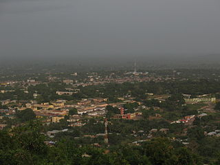
Bolgatanga, colloquially known as Bolga, is a town and also the capital of the Bolgatanga Municipal and the Upper East Region of Ghana. It share's a border to the north with Burkina Faso. Bolgatanga is 161 km (100 mi) to the north of Tamale. The town lies in the Red Volta Valley, with the White Volta and the cliffs of the Gambaga escarpment to the south of the town forming the southern boundary of the Upper East Region. As of 2021, the town has a population of about 142,509 people constituting females (74,659), representing 52.4 percent than males (67,850) constituting 47.6 percent. Some ethnic groups who lived in large qualities in Bolgatanga are Frafra, Daghati, Akan, Ewe, and Ga-Adangbe. The current mayor of the town is Rex Asanga. Bolgatanga Municipal's population in 2021 was with more females (74,659), repre- senting 52.4 percent than males (67,850) constituting 47.6 percent. The Municipal occupies a land size of 334 Km2 with a population density of 418.7 persons per square kilometre.
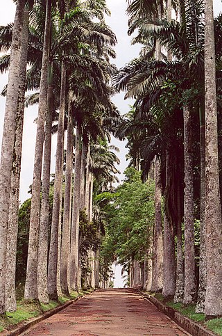
Aburi is a town in the Akuapim South Municipal District of the Eastern Region of south Ghana famous for the Aburi Botanical Gardens and the Odwira festival. Aburi has a population of 18,701 people as of 2013.

Volta Region is one of Ghana's sixteen administrative regions, with Ho designated as its capital. It is located west of Republic of Togo and to the east of Lake Volta. Divided into 25 administrative districts, the region is multi-ethnic and multilingual, including groups such as the Ewe, the Guan, and the Akan peoples. The Guan peoples include the Lolobi, Likpe, Akpafu, Akyode, Buem, Nyagbo, Avatime, and Nkonya. This region was carved out of the Volta Region in December 2018 by the New Patriotic Party. The people of the Volta Region are popularly known as Voltarians. This group includes the Ewes, Guans and other minor tribes living in the Volta Region. The people of the Volta Region are popular known for their rich cultural display and music some of which include Agbadza, Borborbor and Zigi.
Bekwai is a town and the capital of the Bekwai Municipal, a municipality in the Ashanti Region of Ghana. Bekwai is the seventy-ninth most populous settlement in Ghana, with a population of 7,267 people as of 2013. Bekwai and Bekwai Municipal are south of Kumasi and north of Obuasi. As of 2021, the mayor of the municipal is Hon. Kwaku Kyei Baffour.

Bawku is a town and is the capital of the Bawku Municipal District, district in the Upper East region of north Ghana, adjacent to the border with Burkina Faso. It is located approximately between latitudes 11o 111 and 100 401 North and longitude 0o 181w and 0o 61 E in the north-eastern corner of the region. The municipality has a total land area of about 257 km2. The Municipality was established by Legislative Instrument (L.I) 2103. The municipality has a total land area of about 257 km2. Bawku has a 2021 settlement population of 119,458 people. Hon. Ayariga Mahama is the Member of Parliament for Bawku Central Constituency.

Aflao is a border town in the Ketu South District in the Volta Region of Ghana on the border with Togo. Aflao is the twenty-eighth most populous settlement in Ghana, in terms of population, with a population of 66,546 people. The current municipal chief of Aflao is Hon. Maxwell Koffie Lugudor.
Kete Krachi is a town and the capital of the Krachi West District in the Oti Region of Ghana, adjacent to Lake Volta. Kete-Krachi is connected by a ferry to the town of Kwadjokrom, and by road to Bimbila and Dambai. The town has a population of 11,788 people.

Hohoe is a town and the district capital of Hohoe Municipality located in the Volta Region of Ghana. It is about 78 km (48 mi) from Ho, the regional capital and 220 km (140 mi) from Accra, the national capital. The population of Hohoe Municipality, according to the 2010 Population and Housing Census, is 167,016 representing 7.9 per cent of the total population of the Volta Region. It comprises 52.1 per cent females and 47.9 percent males.

Jasikan Municipal District is one of the nine districts in Oti Region, Ghana. Originally created as an ordinary district assembly on 10 March 1989, which was created from the former Jasikan District Council, which it was established by Legislative Instrument (L.I.) 1464, until the western part of the district was split off to create Biakoye District on 29 February 2008, which was established by Legislative Instrument (L.I.) 1901; thus the remaining part has been retained as Jasikan District. It was elevated to municipal status on 11th May, 2021. The district assembly is located in the southern part of Oti Region and has Jasikan as its capital town.

Kpando Municipal District is one of the eighteen districts in Volta Region, Ghana. Originally created as an ordinary district assembly on 10 March 1989 when it was known as Kpando District, until the southern part of the district was split off by a decree of president John Agyekum Kufuor on 19 August 2004 to create South Dayi District; thus the remaining part has been retained as Kpando District. However on 28 June 2012, the southern part of the district was later split off to create North Dayi District on 28 June 2012; while the remaining part was elevated to municipal district assembly status on the same year to become Kpando Municipal District. The municipality is located in the western part of Volta Region and has Kpando as its capital town.
South Dayi District is one of the eighteen districts in Volta Region, Ghana. Originally it was formerly part of the then-larger Kpando District on 10 March 1989, until the southern part of the district was split off by a decree of president John Agyekum Kufuor on 19 August 2004 to create South Dayi District; thus the remaining part has been retained as Kpando District. The district assembly is located in the western part of Volta Region and has Kpeve as its capital town.
Joseph Zaphenat Amenowode is a Ghanaian politician and academic. He was the member of parliament for Hohoe South and was the minister for the Volta Region of Ghana from January 2009 until his dismissal on 6 March 2012. He has worked as a university lecturer prior to going into politics.
Prosper Douglas Kwaku Bani is a Ghanaian international aid and development manager and politician who is a former Chief of staff of Ghana and a former Minister for Interior. He is a senior manager and specialist in international peace-building and development processes. For over 15 years, he led innovative processes in peace and development with the United Nations in several locations, worldwide.
Afadzato South District is one of the eighteen districts in Volta Region, Ghana. Originally it was formerly part of the then-larger Hohoe District on 10 March 1989, until the southern part of the district was split off to create Afadzato South District on 28 June 2012; thus the remaining portion has been retained as Hohoe Municipal District. The district assembly is located in the northern part of Volta Region and has Ve Golokwati as its capital town.

Ve Golokwati is a small town and is the capital of Afadzato South district, a district in central Volta Region of Ghana.
The Oti Region is one of the six newly created regions of Ghana in December 2018. The region was carved out of the Volta Region and will be in fulfillment of a campaign promise made by New Patriotic Party. Prior to the 2016 Ghanaian general election, the then candidate Nana Akufo-Addo declared that when elected, he would explore the possibility of creating new regions out of some of the existing regions in Ghana in order to bring government closer to citizens. The Region was inaugurated on May 14, 2019. It has Dambai as its Regional Capital. The people of Oti region have for more than 60 years always wanted to have a region of their own before its creation in 2018 by the President Nana Addo Dankwa Akufo-Addo led government in December 2018.
North Dayi District is one of the eighteen districts in the Volta Region of Ghana. Originally it was part of the then-larger Kpando District until 10 March 1989. The southern part of the district was split off to create North Dayi District on 28 June 2012. Thus, the remaining part was elevated to municipal district assembly status to become Kpando Municipal District on the same year. The district assembly is located in the western part of Volta Region and has Anfoega as its capital town.


