Kultikri

Last updated

Kultikri
Village
West Bengal location map.svg
Red pog.svg
Kultikri
Location in West Bengal, India
India location map.svg
Red pog.svg
Kultikri
Kultikri (India)
Coordinates: 22°10′56.3″N87°09′34.6″E / 22.182306°N 87.159611°E / 22.182306; 87.159611 Coordinates: 22°10′56.3″N87°09′34.6″E / 22.182306°N 87.159611°E / 22.182306; 87.159611
CountryFlag of India.svg  India
State West Bengal
District Jhargram
Population
 (2011)
  Total4,797
Languages
  Official Bengali, Santali, English
Time zone UTC+5:30 (IST)
Lok Sabha constituency Jhargram
Vidhan Sabha constituency Gopiballavpur
Website jhargram.gov.in

Kultikri is a village, in Sankrail CD Block in Jhargram subdivision of Jhargram district in the state of West Bengal, India.

Contents

Geography

Kultikri
Cities and towns in Jhargram subdivision of Jhargram district
CT: census town, R: rural/ urban centre, H: historical/ religious centre
Owing to space constraints in the small map, the actual locations in a larger map may vary slightly

Location

Kultikri is located at 22°10′56.3″N87°09′34.6″E / 22.182306°N 87.159611°E / 22.182306; 87.159611 .

Area overview

Jhargram subdivision, the only one in Jhargram district, shown in the map alongside, is composed of hills, mounds and rolling lands. It is rather succinctly described in the District Human Development Report, 2011 (at that time it was part of Paschim Medinipur district), “The western boundary is more broken and picturesque, for the lower ranges of the Chhotanagpur Hills line the horizon, the jungle assumes the character of forest, and large trees begin to predominate. The soil, however, is lateritic, a considerable area is unproductive, almost uninhabited, especially in the extreme north-west where there are several hills over 1000 feet in height. The remainder of the country is an almost level plain broken only by the sand hills.” [1] 3.48% of the population lives in urban areas and 96.52% lives in the rural areas. 20.11% of the total population belonged to scheduled castes and 29.37% belonged to scheduled tribes. [2]

Note: The map alongside presents some of the notable locations in the subdivision. All places marked in the map are linked in the larger full screen map.

Demographics

According to the 2011 Census of India, Kultikri had a total population of 1797 of which 907 (50%) were males and 890 (50%) were females. Population in the age range 0–6 years was 89. The total number of literate persons in Kultikri was 622 (78.04% of the population over 6 years). [3]

Transport

Kultikri is on the Rogra-Hatigeria Road which meet State Highway 5 at Hatigeria. The Guptamoni-Kultikri Road and the Kultikri-Poradiha Road, both meet National Highway 49, converge on the village. More over, another two PMGSY roads which connect two corner sides. [4]

Education

Sankrail Anil Biswas Smriti Mahavidyalaya was established in 2007 and is affiliated to Vidyasagar University. It offers arts courses with honours in English, Bengali, Sanskrit, Santali, history and political science. [5]

Kultikri Teachers' Training Institute of Higher Studies is also a D.El.Ed. Cum B.Ed. training Institute affiliated to West Bengal University of Teachers' Training, Education Planning and Administration

There are several high schools here for school level education, among of them notable are Kultikri Girls' High School, Kultikri S.C. High School(established 1945), one of the oldest and renowned school of this area as well as the district.

Related Research Articles

Paschim Medinipur district District of West Bengal in India

Paschim Medinipur district or West Midnapore district is one of the districts of the state of West Bengal, India. It was formed on 1 January 2002 after the Partition of Midnapore into Paschim Medinipur and Purba Medinipur. On 4 April 2017, the Jhargram subdivision was converted into a district.

Gopiballavpur Village in West Bengal, India

Gopiballavpur is a village and a gram panchayat in the Gopiballavpur I CD block in the Jhargram subdivision of the Jhargram district of West Bengal, India.

Lalgarh, Jhargram Village in West Bengal, India

Lalgarh is a village and a gram panchayat in the Binpur I CD block under the Jhargram subdivision of the Jhargram district in the Indian state of West Bengal.

Jhargram subdivision Subdivision in West Bengal, India

Jhargram Sadar Subdivision is an administrative Subdivision of the Jhargram district in the state of West Bengal, India. It became part of the Jhargram district from 4 April 2017 after splitting from the Paschim Medinipur district.

Kharagpur subdivision Subdivision in West Bengal, India

Kharagpur subdivision is an administrative subdivision of Paschim Medinipur district in the state of West Bengal, India.

Goaltore Village in West Bengal, India

Goaltore also Goaltor is a village in the Garhbeta II CD block in the Medinipur Sadar subdivision of the Paschim Medinipur district in West Bengal, India.

Rohini, West Bengal Village in West Bengal, India

Rohini is a village and a gram panchayat in the Sankrail CD block in the Jhargram subdivision of the Jhargram district, in the state of West Bengal, India.

Keshpur Village in West Bengal, India

Keshpur is a village in the Keshpur CD block in the Medinipur Sadar subdivision of the Paschim Medinipur district in the state of West Bengal, India.

Jamboni (community development block) Community development block in West Bengal, India

Jamboni is a community development block that forms an administrative division in Jhargram subdivision of Jhargram district in the Indian state of West Bengal.

Jhargram (community development block) Community development block in West Bengal, India

Jhargram is a community development block that forms an administrative division in Jhargram subdivision of Jhargram district in the Indian state of West Bengal.

Sankrail, Jhargram (community development block) Community development block in West Bengal, India

Sankrail is a community development block that forms an administrative division in Jhargram subdivision of Jhargram district in the Indian state of West Bengal.

Sankrail Anil Biswas Smriti Mahavidyalaya

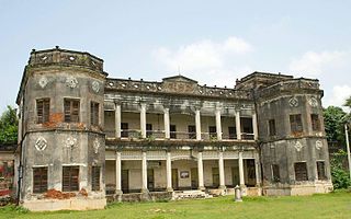
Sankrail Anil Biswas Smriti Mahavidyalaya, also known as Kultikri College, established in 2007, is a college in Kultikri, in the Jhargram district. It offers undergraduate courses in arts. It is affiliated to Vidyasagar University.

Satbankura Village in West Bengal, India

Satbankura is a village and a gram panchayat in the Garhbeta III CD block in the Medinipur Sadar subdivision of the Paschim Medinipur district in the state of West Bengal, India. The headquarters of this block are located here.

Baligeria Village in West Bengal, India

Baligeria is a village in the Nayagram CD block in the Jhargram subdivision of the Jhargram district in the state of West Bengal, India.

Sankrail, Jhargram Village in West Bengal, India

Sankrail is a village in the Sankrail CD block in the Jhargram subdivision of the Jhargram district in the state of West Bengal, India.

Lodhasuli Village in West Bengal, India

Lodhasuli is a village in the Jhargram CD block in the Jhargram subdivision of Jhargram district in the state of West Bengal, India.

Sijua, Jhargram Village in West Bengal, India

Sijua is a village and a gram panchayat in the Binpur I CD block in the Jhargram subdivision of the Jhargram district in the state of West Bengal, India.

Gangaram Chak Village in West Bengal, India

Gangaram Chak is a village, in the Debra CD block in the Kharagpur subdivision of the Paschim Medinipur district in the state of West Bengal, India.

Kapgari Village in West Bengal, India

Kapgari is a village and a gram panchayat in the Jamboni CD block in the Jhargram subdivision of the Jhargram district in the state of West Bengal, India.

Bhanga Gar Village in West Bengal, India

Bhanga Gar is a village in the Sankrail CD block in the Jhargram subdivision of the Jhargram district in the state of West Bengal, India.

References

  1. "District Human Development Report Paschim Medinipur, 2011". pages 4-5. Department of Planning and Statistics, Government of West Bengal. Retrieved 10 September 2020.
  2. "District Statistical Handbook Paschim Medinipur, 2013". Table 2.2, 2.4 (a). Department of Planning and Statistics. Retrieved 10 September 2020.
  3. "2011 Census – Primary Census Abstract Data Tables". West Bengal – District-wise. Registrar General and Census Commissioner, India. Retrieved 20 November 2016.
  4. Google maps
  5. "Sankrail Anil Biswas Smriti Mahavidyalaya". College Admission. Retrieved 20 November 2016.