Silda, West Bengal

Last updated

Silda
Census Town
West Bengal location map.svg
Red pog.svg
Silda
India location map 3.png
Red pog.svg
Silda
Coordinates: 22°37′00″N86°49′06″E / 22.6167778°N 86.8182685°E / 22.6167778; 86.8182685
CountryFlag of India.svg  India
State West Bengal
District Jhargram district
Elevation
112 m (367 ft)
Population
 (2011)
  Total5,724
Languages
  Official Bengali, Santali, English
Time zone UTC+5:30 (IST)
ISO 3166 code IN-WB
Vehicle registration WB
Website jhargram.gov.in

Silda (or Shilda) is a census town in the Binpur II CD block in the Jhargram subdivision of the Jhargram district in the Indian state of West Bengal. [1]

Contents

History

Chuar revolt

A raja's palace is situated at Silda. The Raja of Silda state, Raja Mangobinda Roy, revolted against the British Government. This revolution is called Chuar Bidroho.

Silda Camp Attack , 2010

On 15 February 2010, Maoists attacked Silda camp of Eastern Frontier Rifles in which 24 personnel or jawans were killed. The camp was located in the midst of bustling market area of Silda in West Midnapore district (now in Jhargram district ). [2] [3] The family of slain police personnel received compensation of Rs. 15 lakh from the Centre and the State, while Rs. 1 lakh was given to families of civilians killed by Maoists.[ citation needed ]

Geography

Silda, West Bengal
Cities and towns in Jhargram subdivision of Jhargram district
CT: census town, R: rural/ urban centre, H: historical/ religious centre
Owing to space constraints in the small map, the actual locations in a larger map may vary slightly

Location

Silda is surrounded by Jambani Block towards south, Binpur-I Block towards east, Jhargram Block towards south, Sarenga Block towards north. Pin code of silda is 721515.

Area overview

Jhargram subdivision, the only one in Jhargram district, shown in the map alongside, is composed of hills, mounds and rolling lands. It is rather succinctly described in the District Human Development Report, 2011 (at that time it was part of Paschim Medinipur district), “The western boundary is more broken and picturesque, for the lower ranges of the Chhotanagpur Hills line the horizon, the jungle assumes the character of forest, and large trees begin to predominate. The soil, however, is lateritic, a considerable area is unproductive, almost uninhabited, especially in the extreme north-west where there are several hills over 1000 feet in height. The remainder of the country is an almost level plain broken only by the sand hills.” [4] 3.48% of the population lives in urban areas and 96.52% lives in the rural areas. 20.11% of the total population belonged to scheduled castes and 29.37% belonged to scheduled tribes. [5]

Note: The map alongside presents some of the notable locations in the subdivision. All places marked in the map are linked in the larger full screen map.

Demographics

According to the 2011 Census of India, Shilda had a total population of 5,724, of which 2,861 (50%) were males and 2,863 (50%) were females. There were 540 persons in the age range of 0–6 years. The total number of literate persons in Shilda was 4,218 (81.37% of the population over 6 years). [6]

Infrastructure

According to the District Census Handbook 2011, Paschim Medinipur, Shilda covered an area of 1.3776 km2. Among the civic amenities, it had 3 km roads with open drains, the protected water supply involved overhead tank, service reservoir, tap water from treated and untreated sources. It had 503 domestic electric connections. Among the medical facilities it had 7 medicine shops in the town, the nearest dispensary/ health centre being 4 km away . Among the educational facilities it had were 2 primary schools, 2 senior secondary school, 1 general degree college. It had 1 recognised shorthand, typewriting and vocational training institution. Among the social cultural and recreational facilities, it had 2 working women’s hostels, 1 cinema theatre, 1 auditorium/ community hall, 1 public library, 1 reading room. Three important commodities it produced were rice, stone chip, saw mill. It had the branch offices of 1 nationalised bank, 1 cooperative bank, 1 agricultural credit society and 2 non-agricultural credit societies. [7]

Transport

State Highway 9 running from Durgapur (in Paschim Bardhaman district) to Nayagram (in Jhargram district) and State Highway 5 running from Rupnarayanpur (in Paschim Bardhaman district) to Junput (in Purba Medinipur) pass through Silda. [8]

Education

Silda Chandra Sekhar College was established in 1971 at Silda. It is affiliated to Vidyasagar University. It offers courses in Bengali, Santali, English, Sanskrit, History, Political Science, Commerce, Physics, Chemistry and Mathematics. [9]

Culture

Bhairav Than about two km north of Silda Town is an ancient Temple. Here God Shiva is worshipped as Baba Bhairav. A Gramin Mela is held every year on the occasion of Durga Puja: Bijoya Dashami. The people of Jharkhand, Bihar, also gathered here.

Healthcare

There is a primary health centre at Silda, with 6 beds. [10]

See also

Related Research Articles

Durllabhganj is a census town in the Garhbeta III CD block in the Medinipur Sadar subdivision of the Paschim Medinipur district in the state of West Bengal, India.

<span class="mw-page-title-main">Nayagram (community development block)</span> Community development block in West Bengal, India

Nayagram is a community development block that forms an administrative division in Jhargram subdivision of Jhargram district in the Indian state of West Bengal.

<span class="mw-page-title-main">Lalgarh, Jhargram</span> Census Town in West Bengal, India

Lalgarh is a small town and a gram panchayat in the Binpur I CD block under the Jhargram subdivision of the Jhargram district in the Indian state of West Bengal.

<span class="mw-page-title-main">Jhargram subdivision</span> Subdivision in West Bengal, India

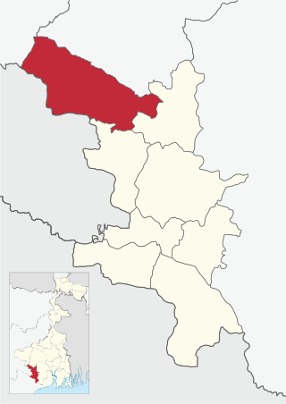
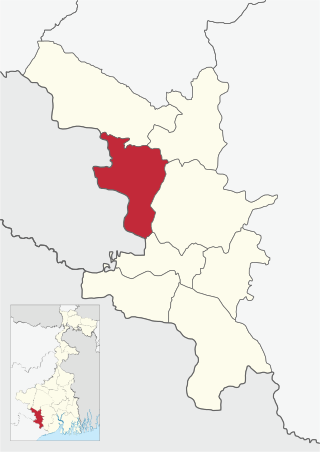
Jhargram Sadar Subdivision is an administrative Subdivision of the Jhargram district in the state of West Bengal, India. It became part of the Jhargram district from 4 April 2017 after splitting from the Paschim Medinipur district.

<span class="mw-page-title-main">Binpur I</span> Community development block in West Bengal, India

Binpur I is a community development block that forms an administrative division in Jhargram subdivision of Jhargram district in the Indian state of West Bengal.

Kalaikunda is a census town in the Kharagpur I CD block in the Kharagpur subdivision of the Paschim Medinipur district in the state of West Bengal, India.

<span class="mw-page-title-main">Midnapore Sadar (community development block)</span> Community development block in West Bengal, India

Midnapore Sadar is a community development block that forms an administrative division in Medinipur Sadar subdivision of Paschim Medinipur district in the Indian state of West Bengal.

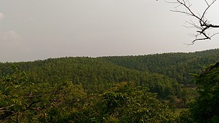
Binpur is a village in the Binpur I CD block in the Jhargram subdivision of the Jhargram district in the state of West Bengal, India.

<span class="mw-page-title-main">Binpur II</span> Community development block in West Bengal, India

Binpur II is a community development block that forms an administrative division in Jhargram subdivision of Jhargram district in the Indian state of West Bengal.

<span class="mw-page-title-main">Jamboni (community development block)</span> Community development block in West Bengal, India

Jamboni is a community development block that forms an administrative division in Jhargram subdivision of Jhargram district in the Indian state of West Bengal.

<span class="mw-page-title-main">Jhargram (community development block)</span> Community development block in West Bengal, India

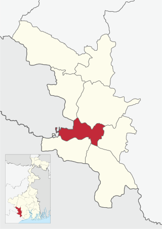
Jhargram is a community development block that forms an administrative division in Jhargram subdivision of Jhargram district in the Indian state of West Bengal.

<span class="mw-page-title-main">Gopiballavpur II</span> Community development block in West Bengal, India

Gopiballavpur II is a community development block that forms an administrative division in Jhargram subdivision of Jhargram district in the Indian state of West Bengal.

<span class="mw-page-title-main">Sankrail, Jhargram (community development block)</span> Community development block in West Bengal, India

Sankrail is a community development block that forms an administrative division in Jhargram subdivision of Jhargram district in the Indian state of West Bengal.

Belpahari is a village in the Binpur II CD block in the Jhargram subdivision of the Jhargram district in West Bengal, India.

Amlagora is a census town in the Garhbeta I CD block in the Medinipur Sadar subdivision of the Paschim Medinipur district in the state of West Bengal, India.

Gidhni is a village in the Jamboni CD block in the Jhargram subdivision of the Jhargram district in the state of West Bengal, India.

Dahijuri is a village and a gram panchayat in the Binpur I CD block in the Jhargram subdivision of the Jhargram district in the state of West Bengal, India.

<span class="mw-page-title-main">Jhargram district</span> District in West Bengal, India

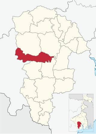
Jhargram is a district in the state of West Bengal, India.The district lies between the Kangsabati River in the north and the Subarnarekha in the south. Jhargram has one of the lowest population densities among the districts of West Bengal, with almost all its population living in rural areas. It is a popular tourist destination known for its sal forests, elephants, ancient temples and royal palaces. The district was formed on 4 April 2017, after bifurcation from the Paschim Medinipur district as the 22nd district of West Bengal. The district has its headquarters at Jhargram.

Dwarigeria is a census town in the Garhbeta III CD block in the Medinipur Sadar subdivision of the Paschim Medinipur district in the state of West Bengal, India.

Naba Kola is a census town in the Garhbeta III CD block in the Medinipur Sadar subdivision of the Paschim Medinipur district in the state of West Bengal, India.

References

  1. "Shilda City Population Census 2011 - West Bengal". www.census2011.co.in. Retrieved 5 November 2015.
  2. "Maoist attack on Silda EFR camp: Buddhadeb says 'failure at the camp level'". The Hindu. 18 March 2010. ISSN   0971-751X . Retrieved 4 November 2015.
  3. "After 3 years, Silda attacker held in TN". Hindustan Times. Retrieved 4 November 2015.
  4. "District Human Development Report Paschim Medinipur, 2011". pages 4-5. Department of Planning and Statistics, Government of West Bengal. Retrieved 10 September 2020.
  5. "District Statistical Handbook Paschim Medinipur, 2013". Table 2.2, 2.4 (a). Department of Planning and Statistics. Retrieved 10 September 2020.
  6. "CD block Wise Primary Census Abstract Data(PCA)". West Bengal – District-wise CD blocks. Registrar General and Census, India. Retrieved 5 September 2020.
  7. "District Census Handbook Paschim Medinipur, Census of India 2011, Series 20, Part XII A" (PDF). Section II Town Directory, Pages 2827-2833; Statement I: Status and Growth History, Page 2827; Statement II: Physical Aspects and Location of Towns, Page 2829; Statement III: Civic and other Amenities, Page 2830; Statement IV: Medical Facilities 2831, Page 2832; Statement V: Educational, Recreational and Cultural Facilities, Page 2832,2833; Statement VI:Industry and Banking ,Page 2833. Directorate of census Operations V, West Bengal. Retrieved 5 September 2020.
  8. "List of State Highways in West Bengal". West Bengal Traffic Police. Retrieved 15 September 2016.
  9. "Silda Chandra Sekhar College". College Admission. Retrieved 5 January 2017.
  10. "Health & Family Welfare Department" (PDF). Health Statistics – Primary Health Centres. Government of West Bengal. Retrieved 15 September 2020.