
Kachin State, also known by the endonym Kachinland, is the northernmost state of Myanmar. It is bordered by China to the north and east ; Shan State to the south; and Sagaing Region and India to the west. It lies between north latitude 23° 27' and 28° 25' longitude 96° 0' and 98° 44'. The area of Kachin State is 89,041 km2 (34,379 sq mi). The capital of the state is Myitkyina. Other important towns include Bhamo, Mohnyin and Putao.
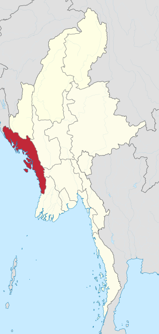
Rakhine State is a state in Myanmar (Burma). Situated on the western coast, it is bordered by Chin State to the north, Magway Region, Bago Region and Ayeyarwady Region to the east, the Bay of Bengal to the west and the Chittagong Division of Bangladesh to the northwest. It is located approximately between latitudes 17°30' north and 21°30' north and longitudes 92°10' east and 94°50' east. The Arakan Mountains or Rakhine Yoma separated Rakhine State from central Burma from North to South. Off the coast of Rakhine State there are some fairly large islands such as Ramree, Cheduba and Myingun. Rakhine State has an area of 36,762 square kilometres (14,194 sq mi) and its capital is Sittwe.

Myanmar is divided into twenty-one administrative subdivisions, which include 7 regions, 7 states, 1 union territory, 1 self-administered division, and 5 self-administered zones. Following is the table of government subdivisions and its organizational structure based on different regions, states, the union territory, the self-administered division, and the self-administered zones:

The Kachin peoples, more precisely the Kachin Wunpong or simply Wunpong, are a confederation of ethnic groups who inhabit the Kachin Hills in Northern Myanmar's Kachin State and neighbouring Yunnan Province, China, as well as Arunachal Pradesh, Assam in Northeastern India. About one million Kachin peoples live in the region. The term Kachin people is often used interchangeably with the main subset, called the Jingpo people in China.
Insurgencies have been ongoing in Myanmar since 1948, the year the country, then known as Burma, gained independence from the United Kingdom. The conflict has largely been ethnic-based, with several ethnic armed groups fighting Myanmar's armed forces, the Tatmadaw, for self-determination. Despite numerous ceasefires and the creation of autonomous self-administered zones in 2008, many armed groups continue to call for independence, increased autonomy, or the federalisation of the country. The conflict is the world's longest ongoing civil war, having spanned more than seven decades.
Yamethin Township is a township of Yamethin District in the Mandalay Region of Burma (Myanmar). The administrative seat and principal city is Yamethin, which is also the major rail stop in the township, and it has a population of 258,091.

Falam Township is a township of Falam District in the Chin State of Burma (Myanmar). Its administrative seat is the town of Falam. The population, as of 2014, is 41,457. Out of this population, 9,092 live in Falam town and 32,365 live in rural areas.

Mohnyin Township is a township of Mohnyin District in the Kachin State of Burma (Myanmar). The principal town and administrative centre is Mohnyin. Jade and gem quality kyanite are produced in Mohnyin Township, as well as amber, gold, asafoetida, and jasper. Indawgyi Lake Wildlife Sanctuary is located in the central north of the township.

Taunggyi Township is a township of Taunggyi District in the Shan State of Myanmar. The principal town is Taunggyi.

Kutkai Township is a township of Muse District in the Shan State of eastern Burma. The principal town is Kutkai.

Nawnghkio Township is a township of Kyaukme District in the Shan State of eastern Myanmar. The principal town and administrative seat is Nawnghkio. The name 'Nawnghkio' was started to call after a camp near a green lake. The lake is located in the west of 'Haw Taw Monastery' of today's Nawnghkio.
Htantabin Township is a township located on the western border of central Yangon Region, Burma (Myanmar). Its administrative seat is Htantabin which is located in the southeastern part of the township on the western bank of the Hlaing River just south of its confluence with the Kokkowa River.

Hkamti Township or Khamti Township is a township in Hkamti District in the Sagaing Region of Burma (Myanmar). The principal town is Hkamti. As of 2014 the township had a population of 47,658 people and covered an area of 8,174 square kilometres (3,156 sq mi). The township is dominated by the Chindwin River and its tributaries as well as thickly forested areas. Nearly half the active working population are employed in agriculture, forestry or fishing. The township is a producer of rice and has gold and jade reserves.

Daik-U Township is a township in Nyaunglebin District in the Bago Region of Burma. The principal town is Daik-U.
Dekkhinathiri Township is one of Naypyidaw Union Territory's eight townships, located south of Mandalay Region in Burma. The township is home to Maravijaya Buddha, the world's largest Buddha marble statue.
Ottarathiri Township is one of Naypyidaw Union Territory's eight townships, located south of Mandalay Region in Burma.

The Arakan Army is an ethnic armed organisation based in Rakhine State (Arakan). Founded on 10 April 2009, the AA is the military wing of the United League of Arakan (ULA). It is currently led by commander in chief Major General Twan Mrat Naing and vice deputy commander Brigadier General Nyo Twan Awng. The Arakan Army states that the objective of its armed revolution is to restore the sovereignty of the Arakan people. In a December 2021 interview, Twan Mrat Naing claimed that the AA had grown to 30,000 troops.
The Fall of Manerplaw occurred on 27 January 1995, when the village of Manerplaw was captured and occupied by the Tatmadaw and the Democratic Karen Buddhist Army (DKBA). Manerplaw was the headquarters of two armed opposition groups, the Karen National Union (KNU) and the All Burma Students' Democratic Front (ABSDF). The final military assault by the Tatmadaw, aided by positional information provided by the DKBA, was met with little resistance by the KNLA, whose leaders had ordered a tactical retreat.
Violent clashes have been ongoing in the northern part of Myanmar's Rakhine State since October 2016. Insurgent attacks by the Arakan Rohingya Salvation Army (ARSA) have led to sectarian violence perpetrated by Myanmar's military and the local Buddhist population against predominantly Muslim Rohingya civilians. The conflict has sparked international outcry and was described as an ethnic cleansing by the United Nations High Commissioner for Human Rights. In August 2017, the situation worsened and hundreds of thousands of refugees fled Myanmar into Bangladesh, with an estimated 500,000 refugees having arrived by 27 September 2017. In January 2019, Arakan Army insurgents raided border police posts in Buthidaung Township, joining the conflict and beginning their military campaign in northern Rakhine State against the Burmese military.
The Kalay clashes are a series of clashes between the Tatmadaw and armed protestors in the town of Kalay and villages surrounding it in Kale Township during the 2021–2022 anti-coup insurgency in Myanmar. The conflict in the township has become one of the first instances of armed resistance to the military of Myanmar apart from actions by Ethnic Armed Organizations during the recent unrest in the country following the February coup.


