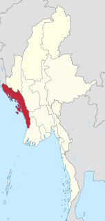
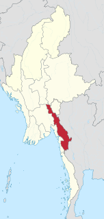
Rakhine State is a state in Myanmar (Burma). Situated on the western coast, it is bordered by Chin State to the north, Magway Region, Bago Region and Ayeyarwady Region to the east, the Bay of Bengal to the west and the Chittagong Division of Bangladesh to the northwest. It is located approximately between latitudes 17°30' north and 21°30' north and longitudes 92°10' east and 94°50' east. The Arakan Mountains or Rakhine Yoma separated Rakhine State from central Burma from North to South. Off the coast of Rakhine State there are some fairly large islands such as Ramree, Cheduba and Myingun. Rakhine State has an area of 36,762 square kilometres (14,194 sq mi) and its capital is Sittwe.

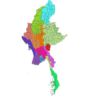
Myanmar is divided into twenty-one administrative subdivisions, which include 7 regions, 7 states, 1 union territory, 1 self-administered division, and 5 self-administered zones. Following is the table of government subdivisions and its organizational structure based on different regions, states, the union territory, the self-administered division, and the self-administered zones:
Bassein may refer to: vasai

Taungoo is a district-level city in the Bago Region of Myanmar, 220 km from Yangon, towards the north-eastern end of the division, with mountain ranges to the east and west. The main industry is in forestry products, with teak and other hardwoods extracted from the mountains. The city is known for its areca palms, to the extent that a Burmese proverb for unexpected good fortune is equated to a "betel lover winning a trip to Taungoo".

Kunlong is the capital town of Kunlong Township in Shan State. its coordination is 23 25' 00" N and 98 39' 00" E.

Insein Township is located in northern Yangon. The township comprises 21 wards, and shares borders with Shwepyitha township in the north, Hlaingthaya township in the west, Mingaladon township in the east and Mayangon township in the south. Insein is home to the Insein Prison, the most notorious prison in the country that houses hundreds of political prisoners. Until the 1990s, Insein, about 20 miles (32 km) from central Yangon, was beyond Yangon's city limits although by the 1980s, Insein was already integrated with the rest of the city. With the expansion of Yangon's city limits in the 1990s which also included founding new satellite towns, Insein was formally incorporated into Yangon.
Articles related to Myanmar include:
Battle of Yunnan-Burma Road was the name of the Chinese intervention to aid their British allies in the 1942 Burma Campaign. Its forces were composed of the Fifth, Sixth and Sixty-sixth Army under the command of the Chinese Expeditionary Force in Burma, commanded by Lt. General Joseph Stilwell, Lt. General Luo Zhuoying was his Executive Officer.

Myitkyina District is a district of the Kachin State in northern Burma (Myanmar). The capital lies at Myitkyina.

Districts are the second-level administrative divisions of Myanmar. They are the sub-divisions of the States and Regions of Myanmar. According to the Myanmar Information Management Unit (MIMU), as of December 2015, there are 76 districts in Myanmar, which in turn are subdivided into townships, then towns, wards and villages.
Lewe Township is one of eight townships of Naypyidaw Union Territory, Burma.

Einme Township is a township of Myaungmya District in the Ayeyarwady Region of Myanmar. The area is believed to be where the Battle of Naungyo took place in 1539.
Buthidaung is a town in Rakhine State, in the westernmost part of Myanmar (Burma). It is the administrative seat of the Buthidaung Township. Buthidaung lies on the west bank of the Mayu river, and experienced severe flooding in June 2010 and July 2011. Buthidaung is 16 miles south from Maungdaw. The two towns are connected by two tunnels through the Mayu mountains that were built in 1918.
Danubyu is a town in the Ayeyarwady Division of south-west Myanmar, located on the west bank of the Ayeyarwaddy River in the Ayeyarwaddy Delta. It is the seat of the Danubyu Township in the Maubin District.

Pekon Township is a township of Taunggyi District in the Shan State of Myanmar. The principal town is Pekon.

Lai-Hka Township is a township of Loilen District in the Shan State of Myanmar. The principal town is Lai-Hka.
Townships are the third-level administrative divisions of Myanmar. They are the sub-divisions of the Districts of Myanmar. According to the Myanmar Information Management Unit (MIMU), as of December 2015, there are 330 townships in Myanmar.
Htauk Kyant is a village in Kale Township, Kale District, in the Sagaing Region of western Burma.

The Kachin conflict or Kachin War is one of the multiple conflicts collectively referred to as the internal conflict in Myanmar. Kachin insurgents have been fighting government soldiers since 1961, with only one ceasefire being brokered between them, which lasted for 17 years from 1994 to 2011.
Kayin State, also known by its former name Karen State, is a state of Myanmar. The capital city is Hpa-An, also spelled Pa-An.


