
Santo Domingo, once known as Santo Domingo de Guzmán, is the capital and largest city of the Dominican Republic and the largest metropolitan area in the Caribbean by population. As of 2010, the city had a total population of 2,908,607, when including the metropolitan area. The city is coterminous with the boundaries of the Distrito Nacional, itself bordered on three sides by Santo Domingo Province.

Comodoro Rivadavia is a city in the Patagonian province of Chubut in southern Argentina, located on the San Jorge Gulf, an inlet of the Atlantic Ocean, at the foot of the Chenque Hill. Comodoro Rivadavia is the most important city of the San Jorge Basin, and the largest city south of the southern 45th parallel.
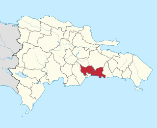
Santo Domingo is a province of the Dominican Republic. It was split from the Distrito Nacional on October 16, 2001.

Teguise is a municipality in the central part of the island of Lanzarote in the Las Palmas province in the Canary Islands. The population is 22,342, and the area is 263.98 km². It is located north of Arrecife and south of Haría. The seat of the municipality is the town of Teguise. The municipality also comprises a number of neighbouring islands including Graciosa, Alegranza, Roque del Este, Roque del Oeste and Montaña Clara.

La Molina is a district of the Lima Province in Peru, and one of the upscale districts that comprise the province of Lima. Officially established as a district on February 6, 1962, the current mayor of La Molina is Álvaro Paz de la Barra.

Boca Chica is a municipality (municipio) of the Santo Domingo province in the Dominican Republic. Within the municipality there is one municipal district : La Caleta. As of the 2012 census it had 123,510 inhabitants, 70,184 living in the city itself and 53,326 in its rural districts (Secciones).

Hermigua is a town and a municipality in the northeastern part of La Gomera in the province of Santa Cruz de Tenerife of the Canary Islands, Spain. It is located 12 km northwest of the island's capital, San Sebastián de la Gomera. The Garajonay National Park covers the southern part of the municipality.

La Carlota is a municipality of small settlements, in the southern half of Spain near Córdoba. In 2005 it had 11,488 inhabitants, and in 2018 just over 14,000, all living in a predominately rural area measuring some 80 km².

DR-3 is one of three main dual carriageway highways of the Dominican Republic, connecting Santo Domingo to the eastern cities of the republic. The highway begins at the Plaza de La Bandera, on the western side of Santo Domingo, and travels eastward through downtown Santo Domingo and continues east to Santo Domingo Este. Outside Santo Domingo it runs roughly parallel to the Caribbean Sea toward the eastern cities of the Dominican Republic. DR-3 creates a rapid connection to the Las Américas International Airport, located only 30 kilometers east of Santo Domingo. DR-3 continues eastward to the beach towns of Andrés and Boca Chica. DR-3 then continues east and slightly north to the eastern cities of San Pedro de Macorís, La Romana, and Higüey and has connections to the routes that lead to the resort towns of Bayahibe, Bávaro, and Punta Cana. DR-3 has been part of a long program to improve, expand, and modernize the highways of the Republic. Most of DR-3 has been expanded to two or three lanes of traffic each way.

Santo Domingo Este is a municipality and the provincial capital of the Santo Domingo province in the Dominican Republic. It has one municipal district, San Luis.

San Juan Bautista Tuxtepec, or simply referred to as Tuxtepec, is the head of the municipality by the same name and is the second most populous city of the Mexican state of Oaxaca. It is part of the Tuxtepec District of the Papaloapan Region. As of the 2020 census, the city is home to a population of 103,609 and 159,452 in the municipality, though census data are often under reported for various reasons. The municipality resides in the region called La Cuenca, is located 36 feet above sea level, and occupies an area of approximately 580 square miles (1,500 km2). The city itself is surrounded by the Papaloapan River, and lies a few kilometers south of the Cerro de Oro Dam on its tributary the Santo Domingo River. The municipality is bordered by the state of Veracruz in the north, the municipalities of Loma Bonita to the east and San José Chiltepec to the south. It is almost 100 miles (160 km) to the port of Veracruz, 130 miles (210 km) to Oaxaca City, the state capital, and 310 miles (500 km) to Mexico City.

San José de las Matas, also known as Sajoma, is an important municipality (municipio) of the Santiago province in the Dominican Republic. The mayor of Sajoma is Roberto Espinal. there has been many positive changes in the last four years such as adding a 911 system. Within the municipality there are three municipal districts : El Rubio, La Cuesta and Las Placetas.

Tlaxiaco is a city, and its surrounding municipality of the same name, in the Mexican state of Oaxaca. It is located in the Tlaxiaco District in the south of the Mixteca Region, with a population of about 17,450.

Punta Caucedo is a small cape located in the south coast of the Dominican Republic, 15 miles (24 km) east from Santo Domingo. Las Américas International Airport is located at Punta Caucedo. It is also Sector in the city of Boca Chica in the Santo Domingo Province of the Dominican Republic.

San Juan is a province of the Dominican Republic. Before 1961 it was known as Benefactor. San Juan is the Republic's largest province, bearing a size of 3,569 square kilometers, and it is landlocked.
Juan Dolio is a small seaside community and tourist destination in the province of San Pedro de Macoris on the southern coast of the Dominican Republic on the island of Hispaniola. Juan Dolio has 2,488 inhabitants and belongs to the district municipality Guayacanes.

The Parque Nacional Submarino La Caleta is a national park located approximately 20 kilometres from Santo Domingo, the capital of the Dominican Republic. It is adjacent to Las Americas International Airport.

Tourism in the Dominican Republic is an important sector of the country's economy. More than 6 million tourists visit the Dominican Republic, making it the most popular tourist destination in the Caribbean and putting it in the top 5 overall in the Americas. The industry accounts for 11.6% of the nation's GDP and is a particularly important source of revenue in coastal areas of the country. The nation's tropical climate, white sand beaches, diverse mountainous landscape and colonial history attracts visitors from around the world.

Carache is one of the 20 municipalities of the state of Trujillo, Venezuela. The municipality occupies an area of 957 km² with a population of 32,820 inhabitants according to the 2011 census.

