La Jacques-Cartier Regional County Municipality

Last updated
La Jacques-Cartier
Quebec MRC La Jacques-Cartier location map.svg
Coordinates: 47°02′N71°35′W / 47.033°N 71.583°W / 47.033; -71.583 [1]
CountryFlag of Canada (Pantone).svg  Canada
Province Flag of Quebec.svg  Quebec
Region Capitale-Nationale
EffectiveApril 1, 1981
County seat Shannon
Municipalities
Government
[2]
  Type Prefecture
  PrefectJacques Marcotte
Area
  Total3,321.20 km2 (1,282.32 sq mi)
  Land3,183.75 km2 (1,229.25 sq mi)
Population
 (2021) [4]
  Total47,813
  Density15/km2 (40/sq mi)
  Change
2016-2021
Increase2.svg 10%
  Dwellings
19,877
Time zone UTC−5 (EST)
  Summer (DST) UTC−4 (EDT)
Area code(s) 418 and 581
Website www.mrc.
lajacquescartier.qc.ca

La Jacques-Cartier is a regional county municipality in the Capitale-Nationale region of Quebec, Canada. The seat is in Shannon. It is named after the Jacques-Cartier River which runs through it and takes its source in its upper country.

Contents

Subdivisions

There are 10 subdivisions within the RCM: [3]

Demographics

Population

Canada census – La Jacques-Cartier community profile
2021 2016 2011
Population47,813 (+10.0% from 2016)43,485 (+17.8% from 2011)36,883 (+24.0% from 2006)
Land area3,183.75 km2 (1,229.25 sq mi)3,195.75 km2 (1,233.89 sq mi)3,194.99 km2 (1,233.59 sq mi)
Population density15/km2 (39/sq mi)13.6/km2 (35/sq mi)11.5/km2 (30/sq mi)
Median age37.2 (M: 37.6, F: 36.8)36.0 (M: 36.4, F: 35.7)35.5 (M: 36.0, F: 34.8)
Private dwellings19,877 (total)  18,301 (occupied)18,401 (total) 16,206 (total) 
Median household income$109,000$90,884$79,769
References: 2021 [5] 2016 [6] 2011 [7] earlier [8] [9]
Historical Census Data - La Jacques-Cartier Regional County Municipality, Quebec
YearPop.±%
1991 23,282    
1996 24,819+6.6%
2001 26,459+6.6%
2006 29,738+12.4%
YearPop.±%
2011 36,883+24.0%
2011rev 36,929+0.1%
2016 43,485+17.8%
2021 47,813+10.0%
[10] [4]

Language

Canada Census Mother Tongue - La Jacques-Cartier Regional County Municipality, Quebec [10]
CensusTotal
French
English
French & English
Other
YearResponsesCountTrendPop %CountTrendPop %CountTrendPop %CountTrendPop %
2021
47,810
45,315Increase2.svg 10.394.8%1,220Decrease2.svg 13.8%2.6%640Increase2.svg 75.3%1.3%500Decrease2.svg 6.5%1.0%
2016
43,410
41,095Increase2.svg 17.8%94.7%1,415Increase2.svg 9.3%3.3%365Increase2.svg 30.4%0.8%535Increase2.svg 67.2%0.9%
2011
36,790
34,895Increase2.svg 25.2%94.9%1,295Increase2.svg 22.2%3.5%280Increase2.svg 30.2%0.8%320Decrease2.svg 39.6%0.9%
2006
29,680
27,875Increase2.svg 13.1%93.9%1,060Decrease2.svg 17.2%3.6%215Increase2.svg 2.4%0.7%530Increase2.svg 112.0%1.8%
2001
26,380
24,640Increase2.svg 7.9%93.4%1,280Decrease2.svg 15.5%4.9%210Increase2.svg 27.3%0.8%250Increase2.svg 35.1%1.0%
1996
24,705
22,840n/a92.5%1,515n/a6.1%165n/a0.7%185n/a0.8%

Transportation

Access Routes

Highways and numbered routes that run through the municipality, including external routes that start or finish at the county border: [11]

See also

Related Research Articles

<span class="mw-page-title-main">Brome-Missisquoi Regional County Municipality</span> Regional county municipality in Quebec, Canada

Brome-Missisquoi is a regional county municipality in the Estrie region of Quebec, Canada. It lies in the Eastern Townships area. The seat is Cowansville. In 2021, it was transferred to the Estrie region from Montérégie.

<span class="mw-page-title-main">La Haute-Gaspésie Regional County Municipality</span> Regional county municipality in Quebec, Canada

La Haute-Gaspésie is a regional county municipality in the Gaspésie–Îles-de-la-Madeleine region of eastern Quebec, Canada, on the Gaspé peninsula. The regional county municipality seat is in Sainte-Anne-des-Monts.

<span class="mw-page-title-main">La Côte-de-Gaspé Regional County Municipality</span> Regional county municipality in Quebec, Canada

La Côte-de-Gaspé is a regional county municipality on the Gaspé peninsula in eastern Quebec, Canada, part of the Gaspésie–Îles-de-la-Madeleine region. The seat is Gaspé.

<span class="mw-page-title-main">Marguerite-D'Youville Regional County Municipality</span> Regional county municipality in Quebec, Canada

Marguerite-D'Youville is a regional county municipality located in the Montérégie region of southwestern Quebec, Canada. The seat is in Verchères.

<span class="mw-page-title-main">La Mitis Regional County Municipality</span> Regional county municipality in Quebec, Canada

La Mitis is a regional county municipality in the Bas-Saint-Laurent region in eastern Quebec, Canada on the Gaspé peninsula. It is named for the Mitis River which has its source in the region and flows through the central part of the region before emptying into the Saint Lawrence River.

<span class="mw-page-title-main">Pierre-De Saurel Regional County Municipality</span> Regional county municipality in Quebec, Canada

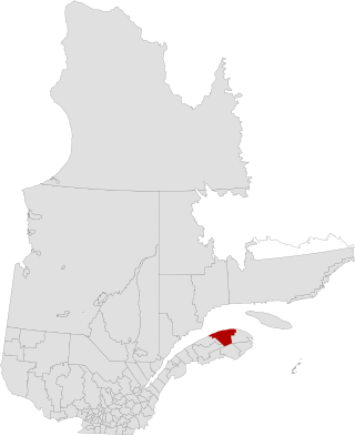
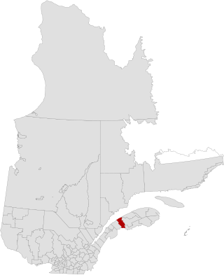
Pierre-De Saurel is a regional county municipality in the Montérégie region in southwestern Quebec, Canada. Originally named Le Bas-Richelieu Regional County Municipality, the name change to Pierre-De Saurel took effect on January 1, 2009. Its seat is in Sorel-Tracy. It is located on the Richelieu River, downstream from La Vallée-du-Richelieu Regional County Municipality at the confluence of the Richelieu and Saint Lawrence River.

<span class="mw-page-title-main">La Matanie Regional County Municipality</span> Regional county municipality in Quebec, Canada

La Matanie is a regional county municipality, located in the Bas-Saint-Laurent region of Quebec, in Canada. From January 1, 1982, to March 9, 2013, it was known as Matane.

<span class="mw-page-title-main">Matawinie Regional County Municipality</span> Regional county municipality in Quebec, Canada

Matawinie is a regional county municipality in the region of Lanaudière in southwestern Quebec, Canada. Its seat is Rawdon. The population according to the 2021 Canadian Census was 55,500.

<span class="mw-page-title-main">Rouville Regional County Municipality</span> Regional county municipality in Quebec, Canada

Rouville is a regional county municipality in the Montérégie region of Quebec, Canada. Its seat is Marieville.

<span class="mw-page-title-main">La Vallée-de-l'Or Regional County Municipality</span> Regional county municipality in Quebec, Canada

La Vallée-de-l'Or(The Golden Valley) is a regional county municipality in the Abitibi-Témiscamingue region in Northwestern Quebec, Canada. The seat is in Val-d'Or. It is named for its gold deposits in the Harricana River and Bell River valleys.

<span class="mw-page-title-main">Baie-Trinité, Quebec</span> Village municipality in Quebec, Canada

Baie-Trinité is a village in the Manicouagan Regional County Municipality in the Côte-Nord region of Quebec, Canada. It is located on the coast of the Gulf of Saint Lawrence at the mouth of the Trinity River, a salmon river which flows through the village. The major economic sectors are forestry and fisheries.

<span class="mw-page-title-main">Sainte-Croix, Quebec</span> Municipality in Quebec, Canada

Sainte-Croix is a municipality in and the seat of the Municipalité régionale de comté de Lotbinière in Quebec, Canada. It is part of the Chaudière-Appalaches region and the population is 2,433 as of 2009. The new constitution dates from 2001, after the amalgamation of the parish and the village of Sainte-Croix.

<span class="mw-page-title-main">Saint-Bernard, Quebec</span> Municipality in Quebec, Canada

Saint-Bernard is a municipality in the Municipalité régionale de comté de la Nouvelle-Beauce in Quebec, Canada. It is part of the Chaudière-Appalaches region and the population is 2,535 as of 2021. Constituted in 1845, it is named after Archbishop Bernard-Claude Panet.

<span class="mw-page-title-main">Sainte-Catherine-de-la-Jacques-Cartier</span> City in Quebec, Canada

Sainte-Catherine-de-la-Jacques-Cartier is a town in Quebec, Canada, located in the regional county municipality of La Jacques-Cartier, in the administrative region of Capitale-Nationale. The Jacques-Cartier River passes through the city.

<span class="mw-page-title-main">Saint-Jacques-le-Mineur, Quebec</span> Municipality in Quebec, Canada

Saint-Jacques-le-Mineur is a municipality in the Jardins de Napierville Regional County Municipality in Quebec, Canada, situated in the Montérégie administrative region. The population as of the Canada 2011 Census was 1,672.

<span class="mw-page-title-main">Natashquan</span> Municipality in Quebec, Canada

Natashquan is a municipality in Minganie Regional County Municipality, Côte-Nord region, Quebec, Canada. It should not be confused with the adjacent but separate Innu reserve of Nutashkuan.

<span class="mw-page-title-main">Fossambault-sur-le-Lac</span> City in Quebec, Canada

Fossambault-sur-le-Lac is a city in the south part of Quebec, Canada, in La Jacques-Cartier Regional County Municipality, just north of Quebec City. It had a population of 2,327 as of the Canada 2021 Census. It is located near Saint-Joseph Lake.

<span class="mw-page-title-main">Saint-Malo, Quebec</span> Municipality in Quebec, Canada

Saint-Malo is a municipality in Quebec, Canada, on the Canada–United States border. Saint-Malo has the highest elevation of any municipality in Quebec. At 640 metres (2,100 ft), local residents live in an environment of forests, farms, and waterways that supply their livelihood.

<span class="mw-page-title-main">Lac-Croche, Quebec</span> Unorganized territory in Quebec, Canada

Lac-Croche is an unorganized territory in the Capitale-Nationale region of Quebec, Canada, in the north of La Jacques-Cartier Regional County Municipality, taking up more than 50% of this regional county. It is unpopulated and undeveloped, almost entirely part of the Laurentides Wildlife Reserve.

<span class="mw-page-title-main">Lac-Jacques-Cartier, Quebec</span> Unorganized territory in Quebec, Canada

Lac-Jacques-Cartier is a large unorganized territory in the Capitale-Nationale region of Quebec, Canada, in the La Côte-de-Beaupré Regional County Municipality, making up more than 85% of this regional county. It is unpopulated and undeveloped, almost entirely part of the Jacques-Cartier National Park and the Laurentides Wildlife Reserve.

References

  1. "Reference number 141093 in Banque de noms de lieux du Québec". toponymie.gouv.qc.ca (in French). Commission de toponymie du Québec.
  2. Ministère des Affaires municipale et des Régions du Québec. "MRC La Jacques-Cartier - Répertoire des municipalités". Archived from the original on 2009-01-18. Retrieved 2009-04-15.
  3. 1 2 "Geographic code 220 in the official Répertoire des municipalités". www.mamh.gouv.qc.ca (in French). Ministère des Affaires municipales et de l'Habitation.
  4. 1 2 3 "Census Profile, 2021 Census: La Jacques-Cartier, Municipalité régionale de comté [Census division], Quebec". Statistics Canada. Retrieved September 8, 2022.
  5. "2021 Community Profiles". 2021 Canadian Census . Statistics Canada. February 4, 2022. Retrieved 2023-10-19.
  6. "2016 Community Profiles". 2016 Canadian Census . Statistics Canada. August 12, 2021. Retrieved 2019-12-12.
  7. "2011 Community Profiles". 2011 Canadian Census . Statistics Canada. March 21, 2019. Retrieved 2014-03-02.
  8. "2006 Community Profiles". 2006 Canadian Census . Statistics Canada. August 20, 2019.
  9. "2001 Community Profiles". 2001 Canadian Census . Statistics Canada. July 18, 2021.
  10. 1 2 Statistics Canada: 1996, 2001, 2006, 2011, 2016, 2021 census
  11. Official Transport Quebec Road Map