Portneuf Regional County Municipality

Last updated
Portneuf
Quebec MRC Portneuf location map.svg
Coordinates: 46°53′N71°55′W / 46.883°N 71.917°W / 46.883; -71.917 Coordinates: 46°53′N71°55′W / 46.883°N 71.917°W / 46.883; -71.917 [1]
CountryFlag of Canada (Pantone).svg  Canada
Province Flag of Quebec.svg  Quebec
Region Capitale-Nationale
EffectiveJanuary 1, 1982
County seat Cap-Santé
Municipalities
Government
[2]
  Type Prefecture
  PrefectDenis Langlois
Area
  Total4,125.10 km2 (1,592.71 sq mi)
  Land3,923.70 km2 (1,514.95 sq mi)
Population
 (2016) [3]
  Total53,008
  Density13.5/km2 (35/sq mi)
  Change
2011-2016
Increase2.svg 7.4%
  Dwellings
26,586
Time zone UTC−5 (EST)
  Summer (DST) UTC−4 (EDT)
Area code(s) 418 and 581
Website www.portneuf.com
[4]

Portneuf is a regional county municipality (RCM) in the Capitale-Nationale administrative region of Quebec, Canada. RCM of Portneuf has been established on January 1, 1982. It is composed of 21 municipalities: nine cities, seven municipalities, two parishes and three unorganized territories. The county seat is located in Cap-Santé.

Contents

History

The Regional County Municipality of Portneuf was constituted as a regional administrative entity on November 25, 1981, by a Provincial decree creating the supralocal Regional County Municipality administration based on the (...) and therefore replacing the previously existing historic Portneuf County Corporation. While the new administrative boundary included most of the communities from its previous historic limits, a few municipalities were merged with bordering entities: St-Augustin-de-Desmaures, Sainte-Catherine-de-Portneuf, Notre-Dame-de-Montauban, Quebec. Those municipalities yet remained within the Electoral Federal Riding of Portneuf District (all but Notre-Dame-de-Mautauban).

The administrative county seat remained in Cap-Santé while moving from the County Corporation building to a newly built one located further east on 185, Route 138 at a slight distance from the historic village of Cap-Santé.

Subdivisions

There are 21 subdivisions within the RCM: [2]

Transportation

Access Routes

Highways and numbered routes that run through the municipality, including external routes that start or finish at the county border: [5]

See also

Related Research Articles

Abitibi-Ouest Regional County Municipality Regional county municipality in Quebec, Canada

Abitibi-Ouest Regional County Municipality is a regional county municipality located in the Abitibi-Témiscamingue region of Quebec. Its seat is La Sarre.

Antoine-Labelle Regional County Municipality Regional county municipality in Quebec, Canada

Antoine-Labelle is a regional county municipality located in the Laurentides region of Quebec, Canada. Its seat is Mont-Laurier. It is named for Antoine Labelle.

Arthabaska Regional County Municipality Regional county municipality in Quebec, Canada

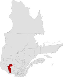
Arthabaska Regional County Municipality is a regional county municipality located in the Centre-du-Québec region of Quebec. Its seat is Victoriaville.

Portneuf County is a historic county in Quebec, Canada west of Quebec City on the Saint Lawrence River in Canada.

Avignon Regional County Municipality Regional county municipality in Quebec, Canada

Avignon is a regional county municipality located in the Gaspésie–Îles-de-la-Madeleine region of Quebec, Canada. Its seat and largest city is Carleton-sur-Mer.

Beauce-Sartigan Regional County Municipality Regional county municipality in Quebec, Canada

Beauce-Sartigan is a regional county municipality in the Chaudière-Appalaches region of Quebec, Canada. The county seat is Saint-Georges.

Beauharnois-Salaberry Regional County Municipality Regional county municipality in Quebec, Canada

Beauharnois-Salaberry is a regional county municipality in the Montérégie region of Quebec, Canada. Its seat is Beauharnois.

Bellechasse Regional County Municipality Regional county municipality in Quebec, Canada

Bellechasse Regional County Municipality is a regional county municipality in the Chaudière-Appalaches region of Quebec. The county seat is Saint-Lazare-de-Bellechasse.

Brome-Missisquoi Regional County Municipality Regional county municipality in Quebec, Canada

Brome-Missisquoi is a regional county municipality in the Eastern Townships region of Quebec, Canada. Its seat is Cowansville.

La Matapédia Regional County Municipality Regional county municipality in Quebec, Canada

La Matapédia is a regional county municipality (RCM) in eastern Quebec, Canada at the base of the Gaspé peninsula, in the Bas-Saint-Laurent region. Its seat is in Amqui. It is named after the Matapédia River which runs through the western part of the RCM.

La Vallée-de-la-Gatineau Regional County Municipality Regional county municipality in Quebec, Canada

La Vallée-de-la-Gatineau(The Valley of the Gatineau) is a regional county municipality in the Outaouais region of western Quebec, Canada. The seat is in Gracefield. It was incorporated on January 1, 1983 and was named for its location straddling the Gatineau River north of Low.

Pierre-De Saurel Regional County Municipality Regional county municipality in Quebec, Canada

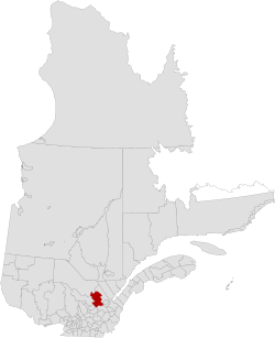
Pierre-De Saurel is a regional county municipality in the Montérégie region in southwestern Quebec, Canada. Originally named Le Bas-Richelieu Regional County Municipality, the name change to Pierre-De Saurel took effect on January 1, 2009. Its seat is in Sorel-Tracy. It is located on the Richelieu River, downstream from La Vallée-du-Richelieu Regional County Municipality at the confluence of the Richelieu and Saint Lawrence River.

Les Collines-de-lOutaouais Regional County Municipality Regional county municipality in Quebec, Canada

Les Collines-de-l'Outaouais is a regional county municipality in the Outaouais region of western Quebec, Canada. The region nearly encircles the City of Gatineau, which is to the south. Its administrative seat is in Chelsea, Quebec.

Les Jardins-de-Napierville Regional County Municipality Regional county municipality in Quebec, Canada

Les Jardins-de-Napierville(English: The Gardens of Napierville) is a regional county municipality (French: Municipalité régionale de comté ) in southwestern Quebec, Canada in the Montérégie region. Founded on January 1, 1982. Its seat is Napierville.

Témiscamingue Regional County Municipality Regional county municipality in Quebec, Canada

Témiscamingue is a regional county municipality in the Abitibi-Témiscamingue region of western Quebec, Canada. The county seat is Ville-Marie.

Regional county municipality County-like political entities in Quebec, Canada

The term regional county municipality or RCM is used in Quebec to refer to one of 87 county-like political entities. In some older English translations they were called county regional municipality.

Le Haut-Saint-Laurent Regional County Municipality Regional county municipality in Quebec, Canada

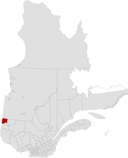
Le Haut-Saint-Laurent(Upper Saint Lawrence) is a regional county municipality in southwestern Quebec, Canada, in the Montérégie region. Its seat is in Huntingdon and it is named for the Saint Lawrence River which forms its western and northwestern boundary.

Les Chenaux Regional County Municipality Regional county municipality in Quebec, Canada

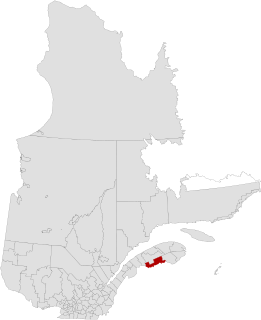
Les Chenaux is a regional county municipality in central Quebec, Canada, in the Mauricie region. The seat is in Saint-Luc-de-Vincennes. It is located adjacent on the east of Trois-Rivières on the Saint Lawrence River. It has a land area of 872.04 square kilometres (336.70 sq mi) and a population of 17,865 inhabitants in the Canada 2011 Census. Its largest community is the parish of Notre-Dame-du-Mont-Carmel.

Notre-Dame-de-Montauban Municipality in Quebec, Canada

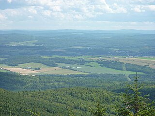
Notre-Dame-de-Montauban is a municipality in the Mauricie region in Canada. This municipality is located at the northern edge of regional county municipality of Mékinac Regional County Municipality and the administrative region of Mauricie. It includes the population centres of Notre-Dame-des-Anges and Montauban-les-Mines. Both communities are located along route 367, about 7 kilometres (4.3 mi) apart.

Portneuf, Quebec City in Quebec, Canada

Portneuf is a municipality in the Portneuf Regional County Municipality, in the province of Quebec, Canada. It is located on the Saint Lawrence River, between Quebec City and Trois-Rivières. The Portneuf River runs on the east side of the town centre.

References

  1. Reference number 141045 of the Commission de toponymie du Québec (in French)
  2. 1 2 3 Geographic code 340 in the official Répertoire des municipalités (in French)
  3. 1 2 "Census Profile, 2016 Census: Portneuf, Municipalité régionale de comté [Census division], Quebec". Statistics Canada. Retrieved December 12, 2019.
  4. Statistics Canada (March 10, 2009). "2011 Community profiles - MRC de Portneuf" . Retrieved 2009-04-15.
  5. Official Transport Quebec Road Map