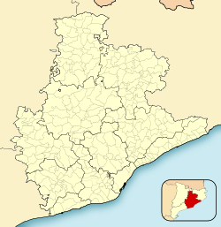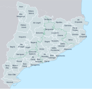
This is a list of the 42 comarques into which Catalonia is divided. A comarca is a group of municipalities, roughly equivalent to a county in the US or a district or council in the UK. However, in the context of Catalonia, the term "county" can be a bit misleading, because in medieval Catalonia, aside from the kings of Aragon, the most important rulers were counts, notably the Counts of Barcelona and of Urgell. Comarques have no particular relation to the "counties" that were ruled by counts.

Olot is the capital city of the comarca of Garrotxa, in the Province of Girona, Catalonia, Spain. The city is known for its natural landscape, including four volcanoes scattered around the city center. The municipality is part of the Zona Volcànica de la Garrotxa Natural Park. Olot is also well known for its cultural activity, with historical art movements like Olot school or factories of religious imagery, which contributed to the location in the city of the main Design and Arts & Crafts school of the province of Girona, the Escola d'Art i Superior de Disseny d'Olot.

Sant Cugat del Vallès is a town and municipality north of Barcelona, Catalonia, Spain. Known as Castrum Octavianum in antiquity and as Pins del Vallès during the Second Spanish Republic, it is named after Saint Cucuphas, who is said to have been martyred on the spot now occupied by its medieval monastery. The final part of its toponym, del Vallès, is a reference to the historical county where the town is situated, Vallès.
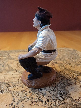
A Caganer is a figurine depicted in the act of defecation appearing in nativity scenes in Catalonia and neighbouring areas with Catalan culture such as Andorra, Valencia, Balearic Islands, and Northern Catalonia. It is most popular and widespread in these areas, but can also be found in other areas of Spain (Murcia), Portugal, and southern Italy (Naples).
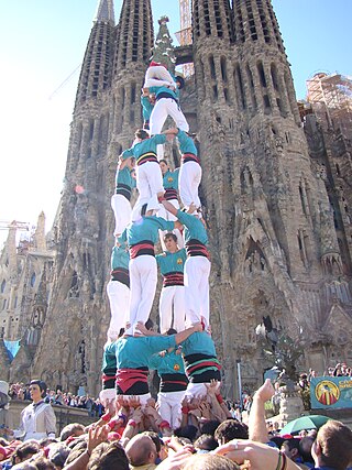
There are quite a number of festivals and traditions in Catalonia (Spain). While most are of ancient origin, certain traditions are of relatively recent introduction. There are also some that are common to the whole Catalan society, but others are relevant only to a particular location. Generally, locals welcome outsiders to share with them in their celebration.

La Bisbal d'Empordà is the county seat of the comarca of Baix Empordà in Catalonia, Spain. The town lies 29 km southeast of Girona, 12 km west of Palafrugell and 19 km northwest of Palamós along road C-66 from Girona to Palafrugell/Palamós, where it becomes C-31. Two other roads branch off at La Bisbal, GI-660 to Calonge and Sant Feliu de Guíxols and GI-664 to Cassà de la Selva; both roads cross the hilly coastal range called the Gavarres, with many twists and turns. The municipality lies on the northern edge of the Gavarres, on either side of the Daró river-bed, a dry tributary of River Ter.
Castellbisbal is a municipality in the comarca of Vallès Occidental in Catalonia. It is situated on the left bank of the Llobregat river at its confluence with the Rubí river. The town is served by the A-7 autopista, the main N-II road and the RENFE railway line R4 between Barcelona and València.
Montcada i Reixac, often referred to as simply Montcada, is a municipality in the comarca of the Vallès Occidental in Catalonia, Spain. It is situated at the confluence of the Ripoll river and the Besós river, and very close to the northernmost neighbourhoods of the city of Barcelona and is therefore a part of the metropolitan area of Barcelona. It had 33,656 inhabitants according to the 2010 census.

Argentona is a municipality in the comarca of the Maresme in Catalonia, Spain. It is situated on the south-east side of the granite Litoral range, to the north-west of Mataró. The town is both a tourist centre and a notable horticultural centre. A local road links the municipality with Cabrera de Mar and with the main N-II road at Vilassar de Mar.
La Pobla de Lillet is a municipality in the comarca of the Berguedà in Catalonia. It is located in the upper valley of the Llobregat river and is linked to Guardiola de Berguedà by Road B-402.

Olesa de Bonesvalls is a village and municipality in the Alt Penedès comarca in Catalonia, Spain. Until 1990 it was included in Garraf comarca.

Sant Celoni is a municipality in the comarca of the Vallès Oriental in Catalonia, Spain. It is situated in the valley of the Tordera river between the ranges of Montseny and Montnegre. The main part of the town is on the left bank of the river. The former municipalities of Montnegre and Olzinelles now form part of the municipality of sant Celoni, which has the largest area in the comarca. The municipality is served by the AP-7 Motorway and the C-251 road, as well as by a station on the RENFE railway line between Barcelona and Girona.

Catalonia is divided into 947 municipalities.
Montferrer i Castellbò is a municipality in the comarca of Alt Urgell, Lleida, Catalonia, Spain.

The national symbols of Catalonia are flags, icons or cultural expressions that are emblematic, representative or otherwise characteristic of Catalonia or Catalan culture.

Puig-reig is a municipality and town in the comarca of Berguedà, Catalonia. As of 2009, the town had a population of 4,403.
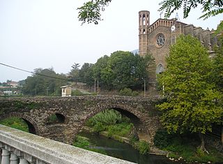
Sant Joan les Fonts is a municipality of the comarca of Garrotxa, located in Girona, Catalonia, northern Spain. As of 2014, the population is 2,919. Until 1949 it was known as Begudà.

Vila-seca is a municipality of the comarca of Tarragonès, in the province of Tarragona, in Catalonia, Spain. The historical name was Vila-seca de Solcina and since the 80's known as Vila-seca i Salou until Salou was segregated from Vila-seca on 1989, however the municipality includes the urban areas of La Plana and La Pineda. Vila-seca has a large petrochemical complex shared with Tarragona and La Canonja, including Repsol complex in El Morell makes one of the greatest petrochemical areas of Europe like Ludwigshafen am Rhein.

Altafulla is a municipality in the comarca of the Tarragonès in Catalonia, Spain. The town of Altafulla has a beautifully intact old quarter crowned by the Castle of Altafulla, and an old fishing quarter dating back to the 18th century along the beach, called "Baixamar" or "Les Botigues de Mar".

Castellcir is a village in the province of Barcelona and autonomous community of Catalonia, Spain. The municipality covers an area of 34.2 square kilometres (13.2 sq mi) and the population in 2014 was 718. The municipality includes an exclave to the west. Since May 2015 it has been part of the new comarca of Moianès; previously it was in Vallès Oriental.