
The Los Angeles Community College District (LACCD) is the community college district serving Los Angeles, California, and some of its neighboring cities and certain unincorporated areas of Los Angeles County. Its headquarters are in Downtown Los Angeles. Over the past seventy-seven years, LACCD has served as educator to more than three million students. In addition to typical college aged students, the LACCD also serves adults of all ages: over half of all LACCD students are older than 25 years of age, and more than a quarter are 35 or older. LACCD educates almost three times as many Latino students and nearly four times as many African-American students as all of the University of California campuses combined. Eighty percent of LACCD students are from underserved populations. The Los Angeles Community College District is the largest community college district in the United States and is one of the largest in the world. The nine colleges within the district offer educational opportunities to students in Los Angeles. It serves students located in the Alhambra, Beverly Hills, Burbank, Culver City, Garvey, Las Virgenes, Los Angeles, Montebello, Palos Verdes and San Gabriel school districts. The district covers the Los Angeles city limits, San Fernando, Calabasas, Agoura Hills, Hidden Hills, Burbank, West Hollywood, Beverly Hills, Culver City, Alhambra, Monterey Park, San Gabriel, Rosemead, Montebello, Commerce, Vernon, Huntington Park, Bell, Cudahy, Bell Gardens, South Gate, Gardena, Carson, Lomita, Palos Verdes Estates, Rolling Hills, Rancho Palos Verdes, and numerous unincorporated communities, including East Los Angeles, Florence-Firestone, Athens, and Walnut Park. The LACCD consists of nine colleges and covers an area of more than 882 square miles (2,280 km2).

San Marino is a city in Los Angeles County, California, United States. It was incorporated on April 25, 1913. At the 2020 United States census the population was 12,513, a decline from the 2010 United States census.

Mission Hills is a neighborhood in Los Angeles, California, located in the San Fernando Valley.

Mount Washington is a historic neighborhood in the San Rafael Hills of Northeast Los Angeles, California. Founded in 1909, it includes the Southwest Museum, the world headquarters of the Self-Realization Fellowship, and Eldred Street, one of the three steepest streets in the United States.

The Santa Clarita Valley (SCV) is part of the upper watershed of the Santa Clara River in Southern California. The valley was part of the 48,612-acre (19,673 ha) Rancho San Francisco Mexican land grant. Located in Los Angeles County, its main population center is the city of Santa Clarita which includes the neighborhoods of Canyon Country, Newhall, Saugus, and Valencia. Adjacent unincorporated communities include Castaic, Stevenson Ranch, Val Verde, and Valencia.

Lake Avenue is a major north–south feeder road for the communities of Pasadena and Altadena in Los Angeles County, California. The road was developed in the mid-19th century and takes its name from a lake that was located at its southernmost end known variously as Mission Lake, Kewen Lake, and Wilson Lake, reflecting different owners of the land. The lake bed still exists as a municipal park in the City of San Marino just south of the Raymond Dike, but it holds no water. It has been surrounded by residences who are served by a crisscross set of roads that dip into the edges of impression and back out the other side. Lake Avenue is approximately 5.06 miles (8.14 km) in length.

The Los Angeles County Arboretum and Botanic Garden, 127 acres, is an arboretum, botanical garden, and historical site nestled into hills near the San Gabriel Mountains in Arcadia, California, United States. Open daily, it only closes on Christmas Day.

Glassell Park is a neighborhood of Northeast Los Angeles, California, in the San Rafael Hills.

Fort Tejon in California is a former United States Army outpost which was intermittently active from June 24, 1854, until September 11, 1864. It is located in the Grapevine Canyon between the San Emigdio Mountains and Tehachapi Mountains. It is in the area of the Tejon Pass along Interstate 5 in Kern County, California, the main route through the mountain ranges separating the Central Valley from the Los Angeles Basin and Southern California. The fort's location protected the San Joaquin Valley from the south and west.
Central Los Angeles is the historical urban region of the city of Los Angeles, containing downtown Los Angeles, and several nearby regions in southwest Los Angeles County, California.

The Verdugo Mountains, also known as the Verdugo Hills or simply The Verdugos, are a small, rugged mountain range of the Transverse Ranges system in Los Angeles County, California. Located just south of the western San Gabriel Mountains, the Verdugo Mountains region incorporates the cities of Burbank, Glendale, Pasadena, and La Cañada Flintridge; the unincorporated communities of Altadena and La Crescenta-Montrose; as well as the City of Los Angeles neighborhood of Sunland-Tujunga. It is where the borders of the San Gabriel Valley and the San Fernando Valley meet.

California's 29th congressional district is a congressional district in the U.S. state of California based in the north central San Fernando Valley. The district is represented by Democrat Tony Cárdenas.

Cypress Park is a densely populated neighborhood of 10,000+ residents in Northeast Los Angeles, California. Surrounded by hills on three sides, it sits in the valley created by the Los Angeles River and the Arroyo Seco. It is the site of the Rio de Los Angeles State Park, the Los Angeles River Bike Path and other recreational facilities. It hosts one private and four public schools.

Founded in 1915, the Greater Los Angeles Area Council (GLAAC) (#033) served most of the City of Los Angeles as well as several other cities in the greater Los Angeles area. It was one of five Boy Scouts of America councils in Los Angeles County, California. Since its founding in 1915, the Los Angeles Area Council has brought its purpose and values to millions of youth. The Council served 54,567 youth in the Greater Los Angeles Area in 2008 alone.
Rancho Santa Anita was a 13,319-acre (53.90 km2) land grant in present-day Los Angeles County, California given to naturalized Scottish immigrant Hugo Reid and his Kizh people wife. Reid built an adobe residence there in 1839, and the land grant was formally recognized by Governor Pio Pico in 1845. The land grant covered all or portions of the present day cities of Arcadia, Monrovia, Sierra Madre, Pasadena and San Marino. A small portion of the rancho has been preserved as the Los Angeles County Arboretum and Botanic Garden.

Santa Susana Pass State Historic Park is a California State Park of 670.68 acres (2.7141 km2) located in the city of Los Angeles, in Los Angeles County on the boundary between Ventura and Los Angeles counties, between the communities of Chatsworth and Simi Valley. Geologically, the park is located where the Simi Hills meet the Santa Susana Mountains. Here in the western part of the Transverse Ranges, the land is dominated by high, narrow ridges and deep canyons covered with an abundant variety of plant life. The park offers panoramic views of the rugged natural landscape as a striking contrast to the developed communities nearby. The park is also rich in archaeological, historical, and cultural significance.
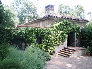
El Molino Viejo, also known as The Old Mill, is a former grist mill in the San Rafael Hills of present-day San Marino, California, United States, and was built in 1816 by Father José María de Zalvidea from the Mission San Gabriel Arcángel. It is the oldest commercial building in Southern California, and was one of the first ten sites in Los Angeles County to be listed on the National Register of Historic Places, receiving the recognition in 1971. The Old Mill has also been designated as a California Historical Landmark.

Oak Knoll is the southernmost neighborhood in Pasadena, California. It is bordered by Oak Knoll Circle to the north, Old Mill Road to the south, South Oak Knoll Avenue and South Oakland Avenue to the west, and the San Marino border to the east.
Rancho Huerta de Cuati was a 127-acre (0.51 km2) Mexican land grant in the San Rafael Hills area of present-day Los Angeles County, California given in 1838 by governor Juan Alvarado to Victoria Reid. The name means "Cuati Garden" in Spanish. The rancho included present-day Alhambra, San Marino, South Pasadena, and Pasadena—and Lake Wilson.
Richard H. Lacy was an American businessman, politician, and pioneer of San Marino, California, serving as its longtime mayor for 18 years. Prior to his election as mayor, Lacy was a major industrialist, oil tycoon, and real estate developer in the Los Angeles area and city councilman.
