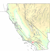
California is a U.S. state on the western coast of North America. Covering an area of 163,696 sq mi (423,970 km2), California is among the most geographically diverse states. The Sierra Nevada, the fertile farmlands of the Central Valley, and the arid Mojave Desert of the south are some of the geographic features of this U.S. state. It is home to some of the world's most exceptional trees: the tallest, most massive, and oldest. It is also home to both the highest and lowest points in the 48 contiguous states.

Southern California is a geographic and cultural region that generally comprises the southern portion of the U.S. state of California. It includes the Los Angeles metropolitan area as well as the Inland Empire. The region generally contains ten of California's 58 counties: Los Angeles, San Diego, Orange, Riverside, San Bernardino, Kern, Ventura, Santa Barbara, San Luis Obispo, and Imperial counties.

The San Andreas Fault is a continental right-lateral strike-slip transform fault that extends roughly 1,200 kilometers (750 mi) through the U.S. state of California. It forms part of the tectonic boundary between the Pacific plate and the North American plate. Traditionally, for scientific purposes, the fault has been classified into three main segments, each with different characteristics and a different degree of earthquake risk. The average slip rate along the entire fault ranges from 20 to 35 mm per year.

The San Fernando Valley, known locally as the Valley, is an urbanized valley in Los Angeles County, California. Situated northwards of the Los Angeles Basin, it comprises a large portion of Los Angeles, the incorporated cities of Burbank, Calabasas, Glendale, Hidden Hills and San Fernando, plus several unincorporated areas. The valley is the home of Warner Bros. Studios, Walt Disney Studios, and the Universal Studios Hollywood theme park.

The Santa Monica Mountains are a coastal mountain range in Southern California, next to the Pacific Ocean. It is part of the Transverse Ranges. The Santa Monica Mountains National Recreation Area encompasses this mountain range. Because of its proximity to densely populated regions, it is one of the most visited natural areas in California.

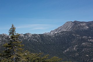
The San Gabriel Mountains comprise a mountain range located in northern Los Angeles County and western San Bernardino County, California, United States. The mountain range is part of the Transverse Ranges and lies between the Los Angeles Basin and the Mojave Desert, with Interstate 5 to the west and Interstate 15 to the east. The range lies in, and is surrounded by, the Angeles and San Bernardino National Forests, with the San Andreas Fault as its northern border.

The Santa Susana Mountains are a transverse range of mountains in Southern California, north of the city of Los Angeles, in the United States. The range runs east-west, separating the San Fernando and Simi valleys on its south from the Santa Clara River Valley to the north and the Santa Clarita Valley to the northeast. The Oxnard Plain is to the west of the Santa Susana Mountains.

The Pomona Valley is located in the Greater Los Angeles Area between the San Gabriel Valley and San Bernardino Valley in Southern California. The valley is approximately 30 miles (48 km) east of downtown Los Angeles.

The Transverse Ranges are a group of mountain ranges of southern California, in the Pacific Coast Ranges physiographic region in North America. The Transverse Ranges begin at the southern end of the California Coast Ranges and lie within Santa Barbara, Ventura, Los Angeles, San Bernardino, Riverside and Kern counties. The Peninsular Ranges lie to the south. The name is due to the ranges' east–west orientation, making them transverse to the general northwest–southeast orientation of most of California's coastal mountains.

The 1971 San Fernando earthquake occurred in the early morning of February 9 in the foothills of the San Gabriel Mountains in southern California. The unanticipated thrust earthquake had a magnitude of 6.5 on the scale and 6.6 on the scale, and a maximum Mercalli intensity of XI (Extreme). The event was one in a series that affected Los Angeles County during the late 20th century. Damage was locally severe in the northern San Fernando Valley and surface faulting was extensive to the south of the epicenter in the mountains, as well as urban settings along city streets and neighborhoods. Uplift and other effects affected private homes and businesses.

The Santa Clarita Valley (SCV) is part of the upper watershed of the Santa Clara River in Southern California. The valley was part of the 48,612-acre (19,673 ha) Rancho San Francisco Mexican land grant. Located in Los Angeles County, its main population center is the city of Santa Clarita which includes the neighborhoods of Canyon Country, Newhall, Saugus, and Valencia. Adjacent unincorporated communities include Castaic, Stevenson Ranch, Val Verde, and Valencia.
The San Jacinto Mountains are a mountain range in Riverside County, located east of Los Angeles in southern California in the United States. The mountains are named for one of the first Black Friars, Saint Hyacinth, who is a popular patron in Latin America.
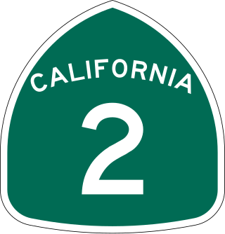
State Route 2 (SR 2) is a state highway in the U.S. state of California. It connects the Los Angeles Basin with the San Gabriel Mountains and the Victor Valley in the Mojave Desert. The highway's southwestern end is at the intersection of Centinela Avenue at the Santa Monica-Los Angeles border and its northeastern end is at SR 138 east of Wrightwood. The SR 2 is divided into four segments, and it briefly runs concurrently with U.S. Route 101 (US 101) and Interstate 210 (I-210). The southwestern section of SR 2 runs along a segment of the east–west Santa Monica Boulevard, an old routing of US 66, to US 101 in East Hollywood; the second section runs along segments of both the north–south Alvarado Street and Glendale Boulevard in Echo Park; the third section to I-210 in Glendale is known as the north–south Glendale Freeway; and the northeastern portion from I-210 in La Cañada Flintridge to SR 138 is designated as the Angeles Crest Highway.

The Simi Hills are a low rocky mountain range of the Transverse Ranges in eastern Ventura County and western Los Angeles County, of southern California, United States.

The Verdugo Mountains, also known as the Verdugo Hills or simply The Verdugos, are a small, rugged mountain range of the Transverse Ranges system in Los Angeles County, California. Located just south of the western San Gabriel Mountains, the Verdugo Mountains region incorporates the cities of Burbank, Glendale, Pasadena, and La Cañada Flintridge; the unincorporated communities of Altadena and La Crescenta-Montrose; as well as the City of Los Angeles neighborhood of Sunland-Tujunga.

Simi Valley is a synclinal valley in Southern California in the United States. It is an enclosed or hidden valley surrounded by mountains and hills. It is connected to the San Fernando Valley to the east by the Santa Susana Pass and the 118 freeway, and in the west the narrows of the Arroyo Simi and the Reagan Freeway connection to Moorpark. The relatively flat bottom of the valley contains soils formed from shales, sandstones, and conglomerates eroded from the surrounding hills of the Santa Susana Mountains to the north, which separate Simi Valley from the Santa Clara River Valley, and the Simi Hills.
There are 9 routes assigned to the "N" zone of the California Route Marker Program, which designates county routes in California. The "N" zone includes county highways lying in Los Angeles and Orange counties.

Most of central and northern California rests on a crustal block (terrane) that is being torn from the North American continent by the passing Pacific plate of oceanic crust. Southern California lies at the southern end of this block, where the Southern California faults create a complex and even chaotic landscape of seismic activity.
The 1991 Sierra Madre earthquake occurred on June 28 at with a moment magnitude of 5.6 and a maximum Mercalli intensity of VII. The thrust earthquake resulted in two deaths, around 100 injuries, and damage estimated at $33.5–40 million. The event occurred beneath the San Gabriel Mountains on the Clamshell–Sawpit Fault, which is a part of the Sierra Madre–Cucamonga Fault System. Instruments captured the event at a number of strong motion stations in Southern California.

The geology of California is highly complex, with numerous mountain ranges, substantial faulting and tectonic activity, rich natural resources and a history of both ancient and comparatively recent intense geological activity. The area formed as a series of small island arcs, deep-ocean sediments and mafic oceanic crust accreted to the western edge of North America, producing a series of deep basins and high mountain ranges.