Related Research Articles

Southern California is a geographic and cultural region that generally comprises the southern portion of the U.S. state of California. It includes the Los Angeles metropolitan area as well as the Inland Empire. The region generally contains ten of California's 58 counties: Los Angeles, San Diego, Orange, Riverside, San Bernardino, Kern, Ventura, Santa Barbara, San Luis Obispo, and Imperial counties.
A blind thrust earthquake occurs along a thrust fault that does not show signs on the Earth's surface, hence the designation "blind". Such faults, being invisible at the surface, have not been mapped by standard surface geological mapping. Sometimes they are discovered as a by-product of oil exploration seismology; in other cases their existence is not suspected.

The Los Angeles Basin is a sedimentary basin located in Southern California, in a region known as the Peninsular Ranges. The basin is also connected to an anomalous group of east–west trending chains of mountains collectively known as the Transverse Ranges. The present basin is a coastal lowland area, whose floor is marked by elongate low ridges and groups of hills that is located on the edge of the Pacific plate. The Los Angeles Basin, along with the Santa Barbara Channel, the Ventura Basin, the San Fernando Valley, and the San Gabriel Basin, lies within the greater Southern California region. The majority of the jurisdictional land area of the city of Los Angeles physically lies within this basin.

The Puente Hills are a chain of hills, one of the lower Transverse Ranges, in an unincorporated area in eastern Los Angeles County, California, in the United States. The western end of the range is often referred to locally as the Whittier Hills. The eastern end is in the city of Chino Hills in San Bernardino County.
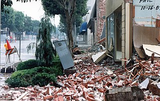
The 1987 Whittier Narrows earthquake occurred in the southern San Gabriel Valley and surrounding communities of Southern California, United States, at 7:42 a.m. PDT on October 1. The moderate magnitude 5.9 blind thrust earthquake was centered several miles north of Whittier in the town of Rosemead, had a relatively shallow depth, and was felt throughout southern California and southern Nevada. Many homes and businesses were affected, along with roadway disruptions, mainly in Los Angeles and Orange counties. Damage estimates ranged from $213–358 million, with 200 injuries, three directly related deaths, and five additional fatalities that were associated with the event.
The Whittier Fault is a geologic fault located in eastern Los Angeles County in Southern California, that is one of the two upper branches of the Elsinore Fault Zone, with the Chino Fault the second.

The Elsinore Fault Zone is a large right-lateral strike-slip geological fault structure in Southern California. The fault is part of the trilateral split of the San Andreas Fault system and is one of the largest, though quietest faults in Southern California.

The San Jacinto Fault Zone (SJFZ) is a major strike-slip fault zone that runs through San Bernardino, Riverside, San Diego, and Imperial Counties in Southern California. The SJFZ is a component of the larger San Andreas transform system and is considered to be the most seismically active fault zone in the area. Together they relieve the majority of the stress between the Pacific and North American tectonic plates.

The 2008 Chino Hills earthquake occurred at 11:42:15 am PDT on July 29 in Southern California. The epicenter of the magnitude 5.4 earthquake was in Chino Hills, c. 28 miles (45 km) east-southeast of downtown Los Angeles. Movement on an oblique-slip fault resulted in a maximum Mercalli intensity of VI (Strong). Though there were no deaths, eight people were injured, and it caused considerable damage in numerous structures throughout the area and caused some amusement park facilities to shut down their rides. The earthquake led to increased discussion regarding the possibility of a stronger earthquake in the future.
The Yorba Linda Fault or Yorba Linda Trend is a fault system that transects the Whittier Fault and extends from northeast Yorba Linda, California to the southeastern portion of the Chino Hills and Chino Hills (city), in San Bernardino County, California.
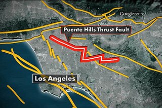
The Puente Hills Fault is an active geological fault that is located in the Los Angeles Basin in California. The thrust fault was discovered in 1999 and runs about 40 km (25 mi) in three discrete sections from the Puente Hills region in the southeast to just south of Griffith Park in the northwest. The fault is known as a blind thrust fault, as the fault plane does not extend to the surface. Large earthquakes on the fault are relatively infrequent but computer modeling has indicated that a major event could have substantial impact in the Los Angeles area. The fault is now thought to be responsible for one moderate earthquake in 1987 and another light event that took place in 2010, with the former causing considerable damage and deaths.
The Hosgri Fault is an offshore fault zone located near the Central Coast of California in San Luis Obispo County. The main fault stretches for about 87 miles (140 km), and is located nearest to the coastal communities of Cambria, San Simeon, Morro Bay, Baywood Park-Los Osos and Avila Beach. The fault system is some 260 mi (420 km) long, and is a right-lateral strand of the San Andreas Fault system.
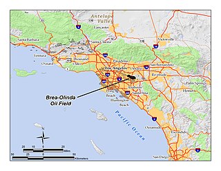
The Brea-Olinda Oil Field is a large oil field in northern Orange County and Los Angeles County, California, along the southern edge of the Puente Hills, about four miles (6 km) northeast of Fullerton, and adjacent to the city of Brea. Discovered in 1880, the field is the sixteenth largest in California by cumulative production, and was the first of California's largest 50 oil fields to be found. It has produced over 430 million barrels of oil in the 130 years since it was first drilled, and retains approximately 20 million barrels in reserve recoverable with current technology. As of the beginning of 2009, 475 wells remained active on the field, operated by several independent oil companies, including Linn Energy, BreitBurn Energy Partners L.P., Cooper & Brain, and Thompson Energy.
The Elsinore Trough is a graben rift valley in Riverside County, southern California. It is created by the Elsinore Fault Zone.
The Perris Block is the central block of three major fault-bounded blocks of the northern part of the Peninsular Ranges. The Perris Block lies between the Santa Ana Block to the west and the San Jacinto Block to the east. The Perris Block, was named by Walter A. English in 1925 for the city of Perris, located near the center of the block.
Wolf Valley is a graben rift valley in the Elsinore Trough, in western Riverside County, California.
The 2019 Ridgecrest earthquakes of July 4 and 5 occurred north and northeast of the town of Ridgecrest, California located in Kern County and west of Searles Valley. They included three initial main shocks of Mw magnitudes 6.4, 5.4, and 7.1, and many perceptible aftershocks, mainly within the area of the Naval Air Weapons Station China Lake. Eleven months later, a Mw 5.5 aftershock took place to the east of Ridgecrest. The first main shock occurred on Thursday, July 4 at 10:33 a.m. PDT, approximately 18 km (11.2 mi) ENE of Ridgecrest, and 13 km (8.1 mi) WSW of Trona, on a previously unnoticed NE-SW trending fault where it intersects the NW-SE trending Little Lake Fault Zone. This quake was preceded by several smaller earthquakes, and was followed by more than 1,400 detected aftershocks. The M 5.4 and M 7.1 quakes struck on Friday, July 5 at 4:08 a.m. and 8:19 p.m. PDT approximately 10 km (6 miles) to the northwest. The latter, now considered the mainshock, was the most powerful earthquake to occur in the state in 20 years. Subsequent aftershocks extended approximately 50 km (~30 miles) along the Little Lake Fault Zone.
The 1987 Superstition Hills earthquake affected the Imperial Valley of California and Baja California on November 24, nearly 12 hours after a Mw 6.0 foreshock, called the Elmore Ranch earthquake. The mainshock, measuring Mw 6.5, struck at 17:54 PST, along the Superstition Hills segment of the San Jacinto Fault Zone. The earthquake generated a 27 km (17 mi) surface rupture with additional postseismic slip continuing for a year.
The 1968 Borrego Mountain earthquake occurred on April 8, at 18:28 PST in the geologically active Salton Trough of Southern California. The Salton Trough represents a pull-apart basin formed by movements along major faults. This region is dominated by major strike-slip faults one of them being the San Jacinto Fault which produced the 1968 earthquake. The mainshock's epicenter was near the unincorporated community of Ocotillo Wells in San Diego County. The moment magnitude (Mw ) 6.6 strike-slip earthquake struck with a focal depth of 11.1 km (6.9 mi). The zone of surface rupture was assigned a maximum Modified Mercalli intensity (MMI) of VII.

The 2014 La Habra earthquake was a magnitude 5.1 earthquake that occurred on March 28, 2014, at 9:09:42 p.m. PDT. Although given the name "La Habra" it was centered in Brea, a city in northern Orange County. Despite its moderate magnitude, it had a maximum Mercalli intensity of VII, and caused a total of $10.8 million in damage. Thirteen water mains broke in Fullerton, forcing roughly 70 families to be displaced from their homes after they were declared temporarily uninhabitable.
References
- ↑ Robert S. Yeats. "The Chino Fault and Its Relation to Slip on the Elsinore and Whittier Faults and Blind Thrusts in the Puente Hills" (PDF). United States Geological Survey. Archived from the original (PDF) on 2016-03-03.
- ↑ D.L. Lamar; S.C. Swanson (1981). "Study of seismic activity by selective trenching along the Elsinore fault zone, Southern California". Open-File Report. 81–882. doi:10.3133/OFR81882. ISSN 0196-1497. Wikidata Q66372720.
- ↑ "Chino Fault". Southern California Earthquake Data Center. Archived from the original on 2009-03-13. Retrieved 2008-11-12.
33°53′N117°35′W / 33.883°N 117.583°W
| | This Riverside County, California-related article is a stub. You can help Wikipedia by expanding it. |
| | This San Bernardino County, California–related article is a stub. You can help Wikipedia by expanding it. |