Southern California is a geographic and cultural region that generally comprises the southern portion of the U.S. state of California. It includes the Los Angeles metropolitan area as well as the Inland Empire. The region generally contains ten of California's 58 counties: Los Angeles, San Diego, Orange, Riverside, San Bernardino, Kern, Ventura, Santa Barbara, San Luis Obispo, and Imperial counties.

The San Andreas Fault is a continental right-lateral strike-slip transform fault that extends roughly 1,200 kilometers (750 mi) through the U.S. state of California. It forms part of the tectonic boundary between the Pacific plate and the North American plate. Traditionally, for scientific purposes, the fault has been classified into three main segments, each with different characteristics and a different degree of earthquake risk. The average slip rate along the entire fault ranges from 20 to 35 mm per year.

Santa Barbara is a coastal city in Santa Barbara County, California, of which it is also the county seat. Situated on a south-facing section of coastline, the longest such section on the West Coast of the United States excepting Alaska, the city lies between the steeply rising Santa Ynez Mountains and the Pacific Ocean. Santa Barbara's climate is often described as Mediterranean, and the city has been dubbed "The American Riviera". According to the 2020 U.S. Census, the city's population was 88,665.

Cupertino is a city in Santa Clara County, California, United States, directly west of San Jose on the western edge of the Santa Clara Valley with portions extending into the foothills of the Santa Cruz Mountains. The population was 60,381 as of the 2020 census. The city is widely known for being the home of Apple Inc., headquartered within the city at Apple Park.

The 1994 Northridge earthquake affected the Los Angeles area of California on January 17, 1994, at 04:30:55 PST. The epicenter of the moment magnitude 6.7 blind thrust earthquake was beneath the San Fernando Valley. Lasting approximately 8 seconds and achieving the largest peak ground acceleration of over 1.7 g, it was the largest earthquake in the area since 1971. Shaking was felt as far away as San Diego, Turlock, Las Vegas, Richfield, Phoenix, and Ensenada. Fifty-seven people died and more than 9,000 were injured. In addition, property damage was estimated to be $13–50 billion, making it among the costliest natural disasters in U.S. history.

The 1971 San Fernando earthquake occurred in the early morning of February 9 in the foothills of the San Gabriel Mountains in southern California. The unanticipated thrust earthquake had a magnitude of 6.5 on the scale and 6.6 on the scale, and a maximum Mercalli intensity of XI (Extreme). The event was one in a series that affected Los Angeles County during the late 20th century. Damage was locally severe in the northern San Fernando Valley and surface faulting was extensive to the south of the epicenter in the mountains, as well as urban settings along city streets and neighborhoods. Uplift and other effects affected private homes and businesses.

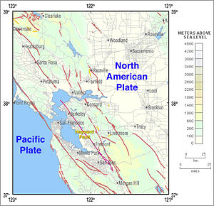
The Hayward Fault Zone is a right-lateral strike-slip geologic fault zone capable of generating destructive earthquakes. The fault was first named in the Lawson Report of the 1906 San Francisco Earthquake in recognition of its involvement in the earthquake of 1868. This fault is about 119 km (74 mi) long, situated mainly along the western base of the hills on the east side of San Francisco Bay. It runs through densely populated areas, including Richmond, El Cerrito, Berkeley, Oakland, San Leandro, Castro Valley, Hayward, Union City, Fremont, and San Jose.
The 1857 Fort Tejon earthquake occurred at about 8:20 a.m. on January 9 in central and Southern California. One of the largest recorded earthquakes in the United States, with an estimated moment magnitude of 7.9, it ruptured the southern part of the San Andreas Fault for a length of about 225 miles, between Parkfield and Wrightwood.
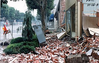
The 1987 Whittier Narrows earthquake occurred in the southern San Gabriel Valley and surrounding communities of Southern California, United States, at on October 1. The moderate magnitude 5.9 blind thrust earthquake was centered several miles north of Whittier in the town of Rosemead, had a relatively shallow depth, and was felt throughout southern California and southern Nevada. Many homes and businesses were affected, along with roadway disruptions, mainly in Los Angeles and Orange counties. Damage estimates ranged from $213–358 million, with 200 injuries, three directly related deaths, and five additional fatalities that were associated with the event.

The Elsinore Fault Zone is a large right-lateral strike-slip geological fault structure in Southern California. The fault is part of the trilateral split of the San Andreas Fault system and is one of the largest, though quietest faults in Southern California.
The Calaveras Fault is a major branch of the San Andreas Fault System that is located in northern California in the San Francisco Bay Area. Activity on the different segments of the fault includes moderate and large earthquakes as well as aseismic creep. The last large event was the magnitude 6.2 1984 Morgan Hill event. The most recent moderate earthquakes were the magnitude 5.1 event on 25 October 2022, and the magnitude 5.6 2007 Alum Rock event.
The 2007 Alum Rock earthquake occurred on in Alum Rock Park in San Jose, in the U.S. state of California. It measured 5.6 on the moment magnitude scale and had a maximum Mercalli intensity of VI (Strong). The event was then the largest in the San Francisco Bay Area since the 1989 Loma Prieta earthquake, which measured 6.9 on the moment magnitude scale, but was later surpassed by the 2014 South Napa earthquake. Ground shaking from the Alum Rock quake reached San Francisco and Oakland and other points further north. Sixty thousand felt reports existed far beyond Santa Rosa, as far north as Eugene, Oregon.
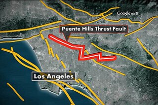
The Puente Hills Fault is an active geological fault that is located in the Los Angeles Basin in California. The thrust fault was discovered in 1999 and runs about 40 km (25 mi) in three discrete sections from the Puente Hills region in the southeast to just south of Griffith Park in the northwest. The fault is known as a blind thrust fault, as the fault plane does not extend to the surface. Large earthquakes on the fault are relatively infrequent but computer modeling has indicated that a major event could have substantial impact in the Los Angeles area. The fault is now thought to be responsible for one moderate earthquake in 1987 and another light event that took place in 2010, with the former causing considerable damage and deaths.

El Sereno Open Space Preserve is a park unit of the Midpeninsula Regional Open Space District located on the peak and slopes of 2580 ft. El Sereno mountain, a peak in the Santa Cruz Mountains. The preserve is located in Santa Clara County, California.
The 1925 Santa Barbara earthquake hit the area of Santa Barbara, California on June 29, with a moment magnitude between 6.5 and 6.8 and a maximum Mercalli Intensity of IX (Violent). It resulted in 13 deaths and destroyed the historic center of the city, with damage estimated at $8 million.
The 1991 Sierra Madre earthquake occurred on June 28 at with a moment magnitude of 5.6 and a maximum Mercalli intensity of VII. The thrust earthquake resulted in two deaths, around 100 injuries, and damage estimated at $33.5–40 million. The event occurred beneath the San Gabriel Mountains on the Clamshell–Sawpit Fault, which is a part of the Sierra Madre–Cucamonga Fault System. Instruments captured the event at a number of strong motion stations in Southern California.
The 1979 Coyote Lake earthquake occurred at on August 6 with a moment magnitude of 5.7 and a maximum Mercalli Intensity of VII. The shock occurred on the Calaveras Fault near Coyote Lake in Santa Clara County, California and resulted in a number of injuries, including some that required hospitalization. Most of the $500,000 in damage that was caused was non-structural, but several businesses were closed for repairs. Data from numerous strong motion instruments was used to determine the type, depth, and extent of slip. A non-destructive aftershock sequence that lasted throughout the remainder of the month was of interest to seismologists, especially with regard to fault creep, and following the event local governments evaluated their response to the incident.
The 1838 San Andreas earthquake is believed to be a rupture along the northern part of the San Andreas Fault in June 1838. It affected approximately 100 km of the fault, from the San Francisco Peninsula to the Santa Cruz Mountains. It was a strong earthquake, with an estimated moment magnitude of 6.8 to 7.2, making it one of the largest known earthquakes in California. The region was lightly populated at the time, although structural damage was reported in San Francisco, Oakland, and Monterey. It is unknown whether there were fatalities. Based on geological sampling, the fault created approximately 1.5 meters of slip.

The 1812 Ventura earthquake occurred on the morning of December 21 at 11:00 Pacific Standard Time (PST). The 7.2 earthquake was assigned a with a maximum Modified Mercalli intensity of X (Extreme). The seismic shaking was followed by a tsunami that considerably damaged places in present-day Santa Barbara and Ventura County, California, which was at the time a territory of the Spanish Empire. One person was killed during the earthquake while another from an aftershock. The earthquake occurred while the region was recovering from another event on December 8.

The San Diego Trough Fault Zone is a group of connected right-lateral strike-slip faults that run parallel to the coast of Southern California, United States, for 150–166 km (93–103 mi). The fault zone takes up 25% of the slip within the Inner Continental Borderlands. Portions of the fault get within 30 km (19 mi) of populated cities; however, the faults never reach shore. The north of the fault zone begins where the San Pedro Basin Fault Zone and the Santa Catalina Fault Zone meet, and the southern section terminates where it reaches the Bahía Soledad Fault. Seismic risk along the fault is high, with potential earthquake scenarios reaching up to magnitude 7.9 in the worst case. An earthquake of this size would devastate coastal areas.