The 1872 Owens Valley earthquake – also known as the Lone Pine earthquake – struck on March 26 at in the Owens Valley, with the epicenter near the town of Lone Pine. Its magnitude has been estimated at 7.4 to 7.9, with a maximum Mercalli Intensity of X (Extreme). It was one of the largest earthquakes to hit California in recorded history and was similar in size to the 1906 San Francisco earthquake. Twenty-seven people were killed and fifty-six were injured.

In geology, a rift is a linear zone where the lithosphere is being pulled apart and is an example of extensional tectonics.

The Hayward Fault Zone is a geologic fault zone capable of generating destructive earthquakes. This fault is about 74 mi (119 km) long, situated mainly along the western base of the hills on the east side of San Francisco Bay. It runs through densely populated areas, including Richmond, El Cerrito, Berkeley, Oakland, San Leandro, Castro Valley, Hayward, Union City, Fremont, and San Jose.

The Seattle Fault is a zone of multiple shallow east-west thrust faults that cross the Puget Sound Lowland and through Seattle in the vicinity of Interstate Highway 90. The Seattle Fault was first recognized as a significant seismic hazard in 1992, when a set of reports showed that about 1,100 years ago it was the scene of a major earthquake of about magnitude 7 – an event that entered Native American oral legend. Extensive research has since shown the Seattle Fault to be part of a regional system of faults.

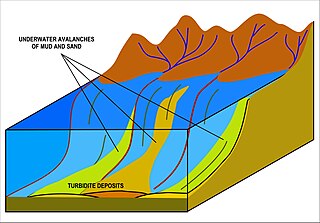
A turbidity current is most typically an underwater current of usually rapidly moving, sediment-laden water moving down a slope; although current research (2018) indicates that water-saturated sediment may be the primary actor in the process. Turbidity currents can also occur in other fluids besides water.
The Silver Creek Fault is a potentially seismically active, northwest-southeast trending strike-slip fault structure in Santa Clara County, California. The Silver Creek Fault runs through and adjacent to the 25-mile-long (40 km), 5-mile-wide (8 km) Evergreen Basin, and generally lies parallel and between the Guadalupe River and Coyote Creek, running directly through the center of San Jose. It also runs parallel to the Hayward Fault, which is located 5 miles (8 km) to the east.

The San Jacinto Fault Zone (SJFZ) is a major strike-slip fault zone that runs through San Bernardino, Riverside, San Diego, and Imperial Counties in Southern California. The SJFZ is a component of the larger San Andreas transform system and is considered to be the most seismically active fault zone in the area. Together they relieve the majority of the stress between the Pacific and North American tectonic plates.

The 1868 Hayward earthquake occurred in the San Francisco Bay Area, California, United States on October 21. With an estimated moment magnitude of 6.3–6.7 and a maximum Mercalli intensity of IX (Violent), it was the most recent large earthquake to occur on the Hayward Fault Zone. It caused significant damage and a number of deaths throughout the region, and was known as the "Great San Francisco earthquake" prior to the 1906 San Francisco earthquake and fire.

The Olympic-Wallowa lineament (OWL) – first reported by cartographer Erwin Raisz in 1945 on a relief map of the continental United States – is a physiographic feature of unknown origin in the state of Washington running approximately from the town of Port Angeles, on the Olympic Peninsula to the Wallowa Mountains of eastern Oregon.

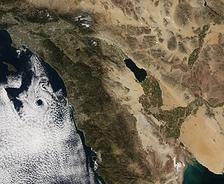
The Brawley Seismic Zone (BSZ), also known as the Brawley fault zone, is a predominantly extensional tectonic zone that connects the southern terminus of the San Andreas Fault with the Imperial Fault in Southern California. The BSZ is named for the nearby town of Brawley in Imperial County, California, and the seismicity there is characterized by earthquake swarms.

The Tacoma Fault, just north of the city of Tacoma, Washington, is an active east–west striking north dipping reverse fault with approximately 35 miles (56 km) of identified surface rupture. It is believed capable of generating earthquakes of at least magnitude Mw 7, and there is evidence of such a quake approximately 1,000 years ago, possibly the same earthquake documented on the Seattle Fault 24 miles (38 km) to the north.

At 04:56 and 06:19 UTC on October 2, 1969, a pair of earthquakes of magnitude 5.6 and 5.7, respectively, struck the city of Santa Rosa, California, killing one person and damaging buildings. The maximum felt intensity for the two events was VII and VIII (Severe) respectively on the Mercalli intensity scale. The $8.35 million cost of the earthquakes went mostly to replace buildings damaged beyond repair. There were at least 200 aftershocks after the initial pair of earthquakes. At the time they were the largest earthquakes to affect the northern San Francisco Bay Area since the 1906 San Francisco earthquake.

The Puget Sound faults under the heavily populated Puget Sound region of Washington state form a regional complex of interrelated seismogenic (earthquake-causing) geologic faults. These include the:

The Marlborough Fault System is a set of four large dextral strike-slip faults and other related structures in the northern part of South Island, New Zealand, which transfer displacement between the mainly transform plate boundary of the Alpine fault and the mainly destructive boundary of the Kermadec Trench, and together form the boundary between the Australian and Pacific Plates.

The 1812 San Juan Capistrano earthquake, also known as the Wrightwood earthquake, occurred on December 8 at in Alta California. At the time, this was a colonial territory of the Spanish Empire. Damage occurred at several of the missions in the region of Pueblo de Los Ángeles, including Mission San Gabriel Arcángel and Mission San Juan Capistrano, where 40 parishioners were killed during the collapse of a church at an early morning service. Tree ring and paleoseismic evidence show that there is a strong likelihood that the earthquake originated along the Mojave segment of the San Andreas Fault near Wrightwood, but other faults have been suggested as the cause.

The 1979 Coyote Lake earthquake occurred at on August 6 with a moment magnitude of 5.7 and a maximum Mercalli Intensity of VII. The shock occurred on the Calaveras Fault near Coyote Lake in Santa Clara County, California and resulted in a number of injuries, including some that required hospitalization. Most of the $500,000 in damage that was caused was non-structural, but several businesses were closed for repairs. Data from numerous strong motion instruments was used to determine the type, depth, and extent of slip. A non-destructive aftershock sequence that lasted throughout the remainder of the month was of interest to seismologists, especially with regard to fault creep, and following the event local governments evaluated their response to the incident.

The 1892 Vacaville–Winters earthquakes occurred in northern California as a large doublet on April 19 and April 21. Measured on a seismic scale that is based on an isoseismal map or the event's felt area, the 6.4 and 6.2 Mla events were assigned a maximum Mercalli intensity of IX (Violent), and affected the North Bay and Central Valley areas. While the total damage was estimated at between $225,000–250,000, one person was killed, but there are no reports on how many people may have been injured. No surface faulting was observed as a result of either strong shocks.

The 1838 San Andreas earthquake is believed to be a rupture along the northern part of the San Andreas Fault in June 1838. It affected approximately 100 km of the fault, from the San Francisco Peninsula to the Santa Cruz Mountains. It was a strong earthquake, with an estimated moment magnitude of 6.8 to 7.2, making it one of the largest known earthquakes in California. The region was lightly populated at the time, although structural damage was reported in San Francisco, Oakland, and Monterey. It is unknown whether there were fatalities. Based on geological sampling, the fault created approximately 1.5 meters of slip.

The 1898 Mare Island earthquake occurred in Northern California on with a moment magnitude of 5.8–6.4 and a maximum Mercalli intensity of VIII–IX (Severe–Violent). Its area of perceptibility included much of northern and central California and western Nevada. Damage amounted to $350,000 and was most pronounced on Mare Island, a peninsula in northern San Francisco Bay. While relatively strong effects there were attributed to vulnerable buildings, moderate effects elsewhere in the San Francisco Bay Area consisted of damaged or partially collapsed structures, and there were media reports of a small tsunami and mostly mild aftershocks that followed.


