Ladakh Chronicles

Last updated

The Ladakh Chronicles, or La-dvags-rgyal-rabs (Tibetan : ལ་དྭགས་རྒྱལ་རབས, Wylie : La dwags rgyal rabs), [lower-alpha 1] is a historical work that covers the history of Ladakh from the beginnings of the first Tibetan dynasty of Ladakh until the end of the Namgyal dynasty. The chronicles were compiled by the Namgyal dynasty, mostly during the 17th century, and are considered the primary written source for Ladakhi history. [1] :17 [2] :1,3 [3] :7

Contents

It remains one of only two surviving pre-19th century literary sources from Ladakh. Only seven original manuscripts of the chronicles are known to have existed, of which two survive today. [2]

Background

August Hermann Francke, whose translation became widely used for studying the Ladakh Chronicles. A H Francke Portrait.jpg
August Hermann Francke, whose translation became widely used for studying the Ladakh Chronicles.

Until the early 19th century, European historians believed that there were no written histories from Ladakh. [4] After reports to the contrary, Alexander Cunningham found the first known manuscript of the chronicles (Ms. Cunningham) during his stay in Ladakh in 1847. [2] [4] :87

The origin, intent, and time of the authorship of the Ladakh Chronicles remains unknown to modern historians. [5] :113 [6] :28 [lower-alpha 2] It remains one of only two surviving pre-19th century literary sources from Ladakh. [2] :3

Manuscripts

There are seven extant manuscripts of the Ladakh Chronicles: [2]

Combined edition and scholarship

In 1926, Tibetologist August Herman Francke published a non-critical translation of the chronicle, in what was the first detailed history of Ladakh. His edition was based on five manuscripts (Ms.S, Ms.A, Ms.B, Ms.C, Ms.L). [3] :77 [2] :1 [10] Francke's edition would become the standard edition for all future studies on the pre-Dogra Ladakh. [2] :1

In the later part of the 20th century, research on the Ladakh Chronicles was complemented by further studies by Joseph Gergan, Luciano Petech, and Zahiruddin Ahmad. [3] :77 [4] [6] :31–32 Petech, in a comparative study with other texts, notes an abundance of omissions and mistakes; he warns against trusting the chronicle blindly. [2] :3 Other scholars have also warned about gaps in the chronicles' treatment of the period before the 17th century. [3] :7 [11] :356 [12] :99

Contents

Maryul (c. 975 CE - 1000 CE) as depicted by A. H. Francke. The border between Maryul and Guge is shown with a thin dotted line, slightly to the north of Gartok; the border between Maryul and Zanskar is marked by a bolded line, slightly to the west of Leh. The Empire of King Nyimagon with three divisions about 975 A. D.- 1000 A.D..jpg
Maryul (c. 975 CE – 1000 CE) as depicted by A. H. Francke. The border between Maryul and Guge is shown with a thin dotted line, slightly to the north of Gartok; the border between Maryul and Zanskar is marked by a bolded line, slightly to the west of Leh.

The Ladakh Chronicles were split into three main sections: the first two sections are about the history of central Tibet; the third section is specifically about Ladakh. [6] :27 The principal chronicle is the Royal Genealogy of Ladakh. [4] The chronicles refers to several dynasties of kings, mentioning that some were descended from the mythological Tibetan hero Gesar. [1] :17 [2] :16

Tibetans controlled the area from 663, and it was controlled by the Tibetan Empire until 842, after which the area was described by the chronicles as splintering into several principalities plagued by warfare and raiding. [1] :17 [2] :13 The chronicles then describe the establishment of Maryul by descendants of the central Tibetan monarchy in the 10th century. [1] :17 [2] :17–18 The chronicles describe the period of conflicts with the Mughal Empire during the late 14th to 16th centuries in Ladakh and Baltistan. [1] :18 [2] :23,26–28,30 The chronicles then describe the development of the Namgyal dynasty and its expansion to Purig in the west and the Tibetan lands of Guge in the east. [1] :18 [2] :28 The latter parts of the Ladakh Chronicles in manuscripts Ms. C and Ms. Sonam contain details about the surprise Dogra invasion of Ladakh. [2] :138–170

The chronicles also cover the first-millennium presence of Buddhism, the growth of Buddhism in the first half of the second millennium, and the introduction of Islam in the 16th century. [1] :17–18 [2] :18–19,30 [13] :121–122

Treaty of Tingmosgang (1684)

The first publication of the Ladakh Chronicles' summary of the 1684 Treaty of Tingmosgang appeared as an appendix to a book by Henry Ramsay. [3] :77 It is held that Prime Minister Desi Sangye Gyatso of Tibet [11] :342:351 and the King Delek Namgyal of Ladakh [2] :171–172 [11] :351–353 agreed on the Treaty of Tingmosgang (sometimes called the Treaty of Temisgam) [13] in the fortress of Tingmosgang at the conclusion of the Tibet–Ladakh–Mughal War in 1684. The original text of the Treaty of Tingmosgang no longer survives, but its contents are summarized in the Ladakh Chronicles. [14] :37:38:40

Monastery of Tingmosgang Temisgang.jpg
Monastery of Tingmosgang

The summary contained in the Ladakh Chronicles includes six main clauses of the treaty: [11] :356 [10] :115–118

  1. A general declaration of principle that the region of Guge (mNa'-ris-sKorgSum) was divided into three separate kingdoms in the 10th century;
  2. The Tibetan recognition of the independence of Ladakh and the restriction for the King of Ladakh from inviting foreign armies into Ladakh;
  3. The regulation of trade of goat-wool, subdivided into two subclauses, for Guge and the northern plain of Tibet (Byaṅ-thaṅ);
  4. A clause fixing the Ladakh-Tibet frontier at the Lha-ri stream at Demchok, but granting Ladakh an enclave at Men-ser;
  5. Another clause regulating Ladakh-Tibet trade;
  6. The arrangement of a fee to Mi-'pham dBaṅ-po (then-regent of Ladakh) for his cost in arranging the treaty.

The trade regulations provided for Ladakh's exclusive right to trade in pashmina wool produced in Tibet, in exchange for brick-tea from Ladakh. Ladakh was also bound to send periodic missions to Lhasa carrying presents for the Dalai Lama. [15] The fee in the sixth clause was later paid by Desi Sangye Gyatso to Mi-'pham dBaii-po in the form of three estates in Tibet sometime between the autumn of 1684 and 1685. [11] :356

Notes

  1. also called the Royal Chronicle of Ladakh
  2. Bray describes the intent of the third chronicle as "to present the Ladakhi royal dynasty in the best possible light". [6] :27
  3. also known as Munshi Tsering Palgyas [6] :29–30

Related Research Articles

<span class="mw-page-title-main">Ladakh</span> Region administered by India

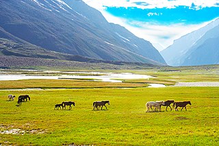
Ladakh is a region administered by India as a union territory and constitutes an eastern portion of the larger Kashmir region that has been the subject of a dispute between India and Pakistan since 1947 and India and China since 1959. Ladakh is bordered by the Tibet Autonomous Region to the east, the Indian state of Himachal Pradesh to the south, both the Indian-administered union territory of Jammu and Kashmir and the Pakistan-administered Gilgit-Baltistan to the west, and the southwest corner of Xinjiang across the Karakoram Pass in the far north. It extends from the Siachen Glacier in the Karakoram range to the north to the main Great Himalayas to the south. The eastern end, consisting of the uninhabited Aksai Chin plains, is claimed by the Indian Government as part of Ladakh, and has been under Chinese control since 1962.

<span class="mw-page-title-main">Guge</span> Historical kingdom in Western Tibet

Guge was an ancient dynastic kingdom in Western Tibet. The kingdom was centered in present-day Zanda County, Ngari Prefecture, Tibet Autonomous Region. At various points in history after the 10th century AD, the kingdom held sway over a vast area including south-eastern Zanskar, upper Kinnaur district, and Spiti Valley, either by conquest or as tributaries. The ruins of the former capital of the Guge kingdom are located at Tsaparang in the Sutlej valley, not far from Mount Kailash and 1,200 miles (1,900 km) west from Lhasa.

Gartok is made of twin encampment settlements of Gar Günsa and Gar Yarsa in the Gar County in the Ngari Prefecture of Tibet. Gar Gunsa served as the winter encampment and Gar Yarsa as the summer encampment. But in British nomenclature, the name Gartok was applied only to Gar Yarsa and the practice continues to date.

<span class="mw-page-title-main">History of Ladakh</span> Aspect of history

Ladakh has a long history with evidence of human settlement from as back as 9000 b.c. It has been a crossroad of high Asia for thousands of years and has seen many cultures, empires and technologies born in its neighbours. As a result of these developments Ladakh has imported many traditions and culture from its neighbours and combining them all gave rise to a unique tradition and culture of its own.

<span class="mw-page-title-main">Suru Valley</span> Valley in Ladakh, India

The Suru Valley is a valley in the Kargil District in the Union Territory of Ladakh, India. It is drained by the Suru River, a tributary of the Indus River. The valley's most significant town is Sankoo.

<span class="mw-page-title-main">Tingmosgang</span> Place in Ladakh, India

Tingmosgang is a fortress in Temisgam village, on the bank of the Indus River in Ladakh, in northwestern India. It is 92 km west of Leh, near Khalatse, and north of the present main road. The town has a palace and the monastery over a hillock.

<span class="mw-page-title-main">Namgyal dynasty of Ladakh</span> Monarchs of the former Ladakh kingdom

The Namgyal dynasty was a dynasty whose rulers were the monarchs of the former kingdom of Ladakh that lasted from 1460 to 1842 and were titled the Gyalpo of Ladakh. The Namgyal dynasty succeeded the first dynasty of Maryul and had several conflicts with the neighboring Mughal Empire and various dynasties of Tibet, including the Tibet–Ladakh–Mughal War. The dynasty eventually fell to the Sikh Empire and Dogras of Jammu and Kashmir. Most of its known history is written in the Ladakh Chronicles.

<span class="mw-page-title-main">Lhachen Palgyigon</span>

Lhachen Palgyigon was the founding king of the Kingdom of Maryul, based in modern Ladakh.

Maryul also called mar-yul of mngah-ris, was the western most Tibetan kingdom based in modern-day Ladakh and some parts of Tibet. The kingdom had its capital at Shey.

The Dogra–Tibetan War or Sino-Sikh War was fought from May 1841 to August 1842, between the forces of the Dogra nobleman Gulab Singh of Jammu, under the suzerainty of the Sikh Empire, and those of Tibet, under the protectorate of the Qing dynasty. Gulab Singh's commander was the able general Zorawar Singh Kahluria, who, after the conquest of Ladakh, attempted to extend its boundaries in order to control the trade routes into Ladakh. Zorawar Singh's campaign, suffering from the effects of inclement weather, suffered a defeat at Taklakot (Purang) and Singh was killed. The Tibetans then advanced on Ladakh. Gulab Singh sent reinforcements under the command of his nephew Jawahir Singh. A subsequent battle near Chushul in 1842 led to a Tibetan defeat. A treaty was signed in 1842 maintaining the status quo ante bellum.

The Tibet–Ladakh–Mughal War of 1679–1684 was fought between the Central Tibetan Ganden Phodrang government, with the assistance of Mongol khanates, and the Namgyal dynasty of Ladakh with assistance from the Mughal Empire in Kashmir.

<span class="mw-page-title-main">Ganden Phodrang</span> Form of Tibetan government

The Ganden Phodrang or Ganden Podrang was the Tibetan system of government established by the 5th Dalai Lama in 1642, after the Oirat lord Güshi Khan who founded the Khoshut Khanate conferred all temporal power on the 5th Dalai Lama in a ceremony in Shigatse in the same year. Lhasa again became the capital of Tibet, and the Ganden Phodrang operated until the 1950s. The Ganden Phodrang accepted China's Qing emperors as overlords after the 1720 expedition, and the Qing became increasingly active in governing Tibet starting in the early 18th century. After the fall of the Qing empire in 1912, the Ganden Phodrang government lasted until the 1950s, when Tibet was annexed by the People's Republic of China. During most of the time from the early Qing period until the end of Ganden Phodrang rule, a governing council known as the Kashag operated as the highest authority in the Ganden Phodrang administration.

Demchok , previously called New Demchok, and called Parigas by the Chinese, is a village and military encampment in the Indian-administered Demchok sector that is disputed between India and China. It is administered as part of the Nyoma tehsil in the Leh district of Ladakh by India, and claimed by China as part of the Tibet Autonomous Region.

Tangtse or Drangtse (Tibetan: བྲང་རྩེ, Wylie: brang rtse, THL: drang tsé) is a village in the Leh district of Ladakh, India. It is located in the Durbuk tehsil. Traditionally, it was regarded as the border between the Nubra region to the north and the Pangong region to the south. It was a key halting place on the trade route between Turkestan and Tibet. It was also a site of wars between Ladakh and Tibet.

The Charding Nullah, traditionally known as the Lhari stream and called Demchok River by China, is a small river that originates near the Charding La pass that is also on the border between the two countries and flows northeast to join the Indus River near a peak called "Demchok Karpo" or "Lhari Karpo". There are villages on both sides of the mouth of the river called by the same name "Demchok", which is presumed to have been a single village originally, and has gotten split into two due to geopolitcal reasons. The river serves as the de facto border between China and India in the southern part of the Demchok sector.

The Demchok sector is a disputed area named after the villages of Demchok in Ladakh and Demchok in Tibet, situated near the confluence of the Charding Nullah and Indus River. It is a part of the greater Sino-Indian border dispute between China and India. Both China and India claim the disputed region, with a Line of Actual Control between the two nations situated along the Charding Nullah.

<span class="mw-page-title-main">Demchok (historical village)</span> Historical village between Ladakh and Tibet

Demchok, was described by a British boundary commission in 1847 as a village lying on the border between the Kingdom of Ladakh and the Tibet. It was a "hamlet of half a dozen huts and tents", divided into two parts by a rivulet which formed the boundary between the two states. The rivulet, a tributary of the Indus River variously called the Demchok River, Charding Nullah, or the Lhari stream, was set as the boundary between Ladakh and Tibet in the 1684 Treaty of Tingmosgang. By 1904–05, the Tibetan side of the hamlet was said to have had 8 to 9 huts of zamindars (landholders), while the Ladakhi side had two. The area of the former Demchok now straddles the Line of Actual Control, the effective border of the People's Republic of China's Tibet Autonomous Region and the Republic of India's Ladakh Union Territory.

<span class="mw-page-title-main">Outline of Ladakh</span> Overview of and topical guide to Ladakh

The following outline is provided as an overview of and topical guide to Ladakh:

<span class="mw-page-title-main">Kyide Nyimagon</span> Tibetan noble

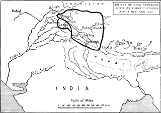
Kyide Nyimagon, whose original name was Khri-skyid-lding, was a member of the Yarlung dynasty of Tibet and a descendant of emperor Langdarma. He migrated to Western Tibet and founded the kingdom of Ngari Khorsum around 912 CE. After his death, his large kingdom was divided among his three sons, giving rise to the three kingdoms of Maryul (Ladakh), Guge-Purang and Zanskar-Spiti.

Tashigang (Tibetan: བཀྲ་ཤིས་སྒང་, Wylie: bkra shis sgang, THL: tra shi gang, transl. "auspicious hillock"), with a Chinese spelling Zhaxigang , is a village in the Gar County of the Ngari Prefecture, Tibet. The village forms the central district of the Zhaxigang Township. It houses an ancient monastery dating to the 11th century.

References

  1. 1 2 3 4 5 6 7 Pirie, Fernanda (2007). Peace and Conflict in Ladakh: The Construction of a Fragile Web of Order. Brill's Tibetan studies library. Vol. 13. Brill Publishers. ISBN   9789004155961.
  2. 1 2 3 4 5 6 7 8 9 10 11 12 13 14 15 16 17 18 19 20 21 22 23 24 25 26 27 28 29 Petech, Luciano (1977). The Kingdom of Ladakh: C. 950-1842 A.D. Istituto italiano per il Medio ed Estremo Oriente. ISBN   9788863230581.
  3. 1 2 3 4 5 Bray, John (2005). "Introduction: Locating Ladakhi History". In Bray, John (ed.). Ladakhi Histories: Local and Regional Perspectives. Brill's Tibetan Studies Library. Vol. 9. Brill Publishers. ISBN   9789004145511.
  4. 1 2 3 4 "Ladakh chronicles". Journal of the Royal Central Asian Society. 28 (1): 87–91. 1941. doi:10.1080/03068374108730998. ISSN   0035-8789.
  5. Jinpa, Nawang (2015). "Why Did Tibet and Ladakh Clash in the 17th Century?: Rethinking the Background to the 'Mongol War' in Ngari (1679-1684)". The Tibet Journal. 40 (2): 113–150. JSTOR   tibetjournal.40.2.113.
  6. 1 2 3 4 5 6 Bray, John (2016). "uciano Petech and the Historiography of Ladakh: Lives, Times and Academic lineages". Rivista degli studi orientali. 89: 27–34. ISSN   0392-4866. JSTOR   45112250.
  7. Marx, Karl (1891). "Three Documents relating to the History of Ladakh: Tibetan Text, Translation, and Notes". Journal of the Asiatic Society of Bengal. 60: 97–135.
  8. Marx, Karl (1894). "Three Documents relating to the History of Ladakh: Tibetan Text, Translation, and Notes". Journal of the Asiatic Society of Bengal. 63: 94–107.
  9. Marx, Karl (1902). "Three Documents relating to the History of Ladakh: Tibetan Text, Translation, and Notes". Journal of the Asiatic Society of Bengal. 71: 21–34.
  10. 1 2 Francke, August Hermann (1926). Thomas, F. W. (ed.). Antiquities of Indian Tibet, Part (Volume) II.
  11. 1 2 3 4 5 Ahmad, Zahiruddin (1968). "New light on the Tibet-Ladakh-Mughal war of 1679—1684". East and West. 18 (3/4): 340–361. JSTOR   29755343.
  12. Emmer, Gerhard (2007). "Dga' Ldan Tshe Dbang Dpal Bzang Po and the Tibet-Ladakh-Mughal War of 1679-84". Proceedings of the Tenth Seminar of the IATS, 2003. Volume 9: The Mongolia-Tibet Interface: Opening New Research Terrains in Inner Asia. BRILL. pp. 81–108. ISBN   978-90-474-2171-9.
  13. 1 2 Howard, Neil (2005). "The Development of the Boundary between the State of Jammu & Kashmir and British India, and its Representation on Maps of the Lingti Plain". In Bray, John (ed.). Ladakhi Histories: Local and Regional Perspectives. Brill's Tibetan Studies Library. Vol. 9. Brill Publishers. p. 218. ISBN   9789004145511.
  14. Lamb, Alastair (1965), "Treaties, Maps and the Western Sector of the Sino-Indian Boundary Dispute" (PDF), The Australian Year Book of International Law: 37–52
  15. Warikoo, K. (2009), "India's gateway to Central Asia: trans-Himalayan trade and cultural movements through Kashmir and Ladakh, 1846–1947", in Warikoo, K. (ed.), Himalayan Frontiers of India: Historical, Geo-Political and Strategic Perspectives, Routledge, p. 4, ISBN   978-1-134-03294-5