The Nueva Esparta State is one of the 23 states of Venezuela. It comprises Margarita Island, Coche, and the largely uninhabited Cubagua.

Margarita Island is the largest island in the Venezuelan state of Nueva Esparta, situated off the northeastern coast of the country, in the Caribbean Sea. The capital city of Nueva Esparta, La Asunción, is located on the island.

The Cabo Orange National Park is a National park located in Amapá state in the north of Brazil, near the border between Brazil and French Guiana.
Lagunas de Mejía National Sanctuary is a protected area on the coastal plain of Peru, in Islay Province, Arequipa, in the mouth of the Tambo River. It is a sanctuary for migratory and resident birds, and was designated a Ramsar site in 1992.

The Lagunas de Chacahuan National Park, created in 1937, is a national park located in the Municipality of Villa de Tututepec de Melchor Ocampo in the Mexican state of Oaxaca, about 54 km west of Puerto Escondido, near a village called Zapotalito. It can be reached via Federal Highway 200 or by boat from Puerto Escondido. It is located between the towns of Santiago Jamiltepec and Puerto Escondido. The park encompasses 132.73 square kilometres, about 30 km2 of which is taken by various lagoons such as the ‘’’Laguna de Chacahua,’’’ ‘’’Laguna de La Pastoria,’’’ and Laguna Las Salinas. There are various smaller lagoons that are connected by narrow channels. The rest of the park consists of dry land. The park has 10 different types of vegetation: “selva espinosa", swampland, deciduous, sub tropical broadleaf, mangroves, savannah, “bosque de galleria”, “tular”, palm trees, and coastal dunes. 246 species of flowers and 189 species of animals have been documented so far in the park. Birds such as storks, herons, wild ducks, blue-winged teals, pelicans, and spoonbills can be found here. Three species of turtles also visit the park to lay their eggs.
The Natural Park of El Fondo is located within the municipal boundaries of Elche and Crevillent both of which are within the comarca (district) of Baix Vinalopó in the south of the Valencian Community in the east of Spain. Both the rivers Vinalopó and Segura discharge into the lagoons that form this park.
Assagny National Park or Azagny National Park is a national park in the south of Ivory Coast. It is situated on the coast some 75 km (47 mi) to the west of Abidjan, between the mouth of the Bandama River and the Ébrié Lagoon, and occupies an area of about 17,000 hectares.

Îles Ehotilé National Park is a national park of the Ivory Coast in the Sud-Comoé region. The park consists of a group of low islands and the intervening channels that separate Aby Lagoon from the Atlantic Ocean.
Lagunas de Zempoala National Park is a natural protected area in Mexico that consists of a group of seven lagoons. In the Nahuatl language, "Zempoala" means "place of many waters." The park is located between the state of Morelos and the state of Mexico.

Tetas de María Guevara are twin hills located near Laguna de la Restinga in central Isla Margarita, Venezuela.

Lagunas de Montebello, or Montebello Lakes, is a national park in the Mexican state of Chiapas, near the border with Guatemala, comprising 59 multi-colored lakes in a pine forest and two Maya ruins. It was the first national park in Chiapas when created in 1959, and in 2009 the park was designated a Biosphere Reserve by UNESCO.

The Macanao Peninsula is a geographic peninsula landform, that forms the western end of the Isla Margarita in the Caribbean Sea, in northern Venezuela.
La Guardia is a fishing and tourist community on the northwest coast of Isla Margarita, Venezuela.

The Ilha do Cardoso State Park is a state park on the coast of the state of São Paulo, Brazil. It preserves a large area of Atlantic Forest on the Ilha do Cardoso, an island, and includes marshes and mangroves that form an important breeding area for marine life. Visitors may reach the island by boat and stay in one of the villages. They may visit the beaches or follow trails into the interior, where there are waterfalls and natural pools.

The Laguna de Tacarigua National Park, also known as Tacarigua Lagoon National Park, is a protected area with the status of a national park located east of Miranda State, close to the town of Laguna de Tacarigua in the South American country of Venezuela. It comprises a permanent coastal lagoon of 7800 ha and 1.2 m of average depth, separated from the sea by a restinga or coastal barrier of 28.8 km long and 300–1000 m wide that was formed by the action of the sea current which runs along the coast in an East-West direction.

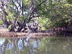
The Laguna de las Marites Natural Monument, or Las Marites Lagoon Natural Monument, is a protected hypersaline lagoon with Natural Monument status located on the south-east coastal plain of Margarita Island, in Nueva Esparta state in the north-west of Venezuela. It was declared a Natural Monument on 27 February 1974.

The El Pinar Zoo Also Zoological Park of El Pinar Is the first zoological garden of Caracas, Venezuela inaugurated 13 August 1945 under the presidency of Isaías Medina Angarita. El pinar zoo is located in El Paraiso Parish in the former grounds of the La Vaquera hacienda, which was owned by Juan Vicente Gómez. The State took possession of it in 1935. It occupies an area of 7 hectares.

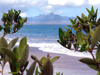
The Araya and Paria xeric scrub (NT1301) is an ecoregion in Venezuela that stretches along the Caribbean coast to the west of Trinidad, and that includes Margarita Island and some smaller islands. The ecoregion includes dune herbs, dry thorn scrubs and deciduous forests. The mountains on Margarita Island hold montane forests similar to those in the mainland coastal range. The beaches are used for breeding by sea turtles. Some endemic bird species are threatened with extinction by illegal capture for the pet trade. Deforestation and over-grazing by goats are also problems.

The Mesoamerican Gulf-Caribbean mangroves ecoregion covers the series of disconnected mangrove habitats along the eastern coast of Central America. These salt-water wetlands are found in river deltas, lagoons, and low-lying areas facing the Gulf of Mexico and Caribbean Sea, from Tampico, Mexico to central Panama. The mangroves are areas of high biodiversity and endemism. Many of the sites are protected as national parks or nature reserves.

The Alvarado mangroves ecoregion covers a series of mangrove forest areas along the Gulf of Mexico coast of the states of Tamaulipas and Veracruz in Mexico. they are the most northerly mangroves in the western Gulf. The largest tracts of mangrove swamps occur at the mouths of rivers, and nearby coastal lagoon.