Lake Almanor Peninsula, California

Last updated
Lake Almanor Peninsula
Plumas County California Incorporated and Unincorporated areas Lake Almanor Peninsula Highlighted.svg
Location in Plumas County and the state of California
Usa edcp location map.svg
Red pog.svg
Lake Almanor Peninsula
Location in the United States
Coordinates: 40°16′31″N121°7′36″W / 40.27528°N 121.12667°W / 40.27528; -121.12667 Coordinates: 40°16′31″N121°7′36″W / 40.27528°N 121.12667°W / 40.27528; -121.12667
Country Flag of the United States.svg  United States
State Flag of California.svg  California
County Plumas
Area
[1]
  Total3.036 sq mi (7.863 km2)
  Land3.036 sq mi (7.863 km2)
  Water0 sq mi (0 km2)  0%
Population
 (2010)
  Total356
  Density120/sq mi (45/km2)
Time zone UTC-8 (Pacific (PST))
  Summer (DST) UTC-7 (PDT)
ZIP code
96137
Area code(s) 530
FIPS code 06-39420

Lake Almanor Peninsula is a census-designated place (CDP) in Plumas County, California, United States. The population was 356 at the 2010 census, up from 336 at the 2000 census.

Contents

Geography

Lake Almanor Peninsula is located at 40°16′31″N121°7′36″W / 40.27528°N 121.12667°W / 40.27528; -121.12667 (40.275319, -121.126715). [2]

According to the United States Census Bureau, the CDP has a total area of 3.0 square miles (7.8 km2), all of it land.

Demographics

Historical population
CensusPop.
U.S. Decennial Census [3]

2010

The 2010 United States Census [4] reported that Lake Almanor Peninsula had a population of 356. The population density was 117.3 inhabitants per square mile (45.3/km2). The racial makeup of Lake Almanor Peninsula was 337 (94.7%) White, 0 (0.0%) African American, 9 (2.5%) Native American, 0 (0.0%) Asian, 0 (0.0%) Pacific Islander, 4 (1.1%) from other races, and 6 (1.7%) from two or more races. Hispanic or Latino of any race were 22 persons (6.2%).

The Census reported that 356 people (100% of the population) lived in households, 0 (0%) lived in non-institutionalized group quarters, and 0 (0%) were institutionalized.

There were 165 households, out of which 32 (19.4%) had children under the age of 18 living in them, 95 (57.6%) were opposite-sex married couples living together, 10 (6.1%) had a female householder with no husband present, 5 (3.0%) had a male householder with no wife present. There were 6 (3.6%) unmarried opposite-sex partnerships, and 0 (0%) same-sex married couples or partnerships. 47 households (28.5%) were made up of individuals, and 18 (10.9%) had someone living alone who was 65 years of age or older. The average household size was 2.16. There were 110 families (66.7% of all households); the average family size was 2.57.

The population was spread out, with 67 people (18.8%) under the age of 18, 15 people (4.2%) aged 18 to 24, 60 people (16.9%) aged 25 to 44, 130 people (36.5%) aged 45 to 64, and 84 people (23.6%) who were 65 years of age or older. The median age was 54.3 years. For every 100 females, there were 110.7 males. For every 100 females age 18 and over, there were 103.5 males.

There were 561 housing units at an average density of 184.8 per square mile (71.4/km2), of which 128 (77.6%) were owner-occupied, and 37 (22.4%) were occupied by renters. The homeowner vacancy rate was 16.3%; the rental vacancy rate was 48.6%. 264 people (74.2% of the population) lived in owner-occupied housing units and 92 people (25.8%) lived in rental housing units.

2000

As of the census [5] of 2000, there were 336 people, 156 households, and 102 families residing in the CDP. The population density was 183.4 inhabitants per square mile (70.8/km2). There were 413 housing units at an average density of 225.5 per square mile (87.1/km2). The racial makeup of the CDP was 95.83% White, 2.08% Native American, 0.89% from other races, and 1.19% from two or more races. Hispanic or Latino of any race were 5.65% of the population.

There were 156 households, out of which 21.8% had children under the age of 18 living with them, 59.0% were married couples living together, 5.1% had a female householder with no husband present, and 34.0% were non-families. 29.5% of all households were made up of individuals, and 10.3% had someone living alone who was 65 years of age or older. The average household size was 2.15 and the average family size was 2.64.

In the CDP, the population was spread out, with 18.5% under the age of 18, 5.4% from 18 to 24, 21.7% from 25 to 44, 34.5% from 45 to 64, and 19.9% who were 65 years of age or older. The median age was 47 years. For every 100 females, there were 95.3 males. For every 100 females age 18 and over, there were 101.5 males.

The median income for a household in the CDP was $26,000, and the median income for a family was $37,250. Males had a median income of $35,139 versus $18,929 for females. The per capita income for the CDP was $15,643. About 7.2% of families and 14.0% of the population were below the poverty line, including 27.9% of those under age 18 and none of those age 65 or over.

Politics

In the state legislature, Lake Almanor Peninsula is in the 1st Senate District , represented by Republican Brian Dahle, [6] and the 1st Assembly District , represented by Republican Megan Dahle. [7]

Federally, Lake Almanor Peninsula is in California's 1st congressional district , represented by Republican Doug LaMalfa. [8]

Related Research Articles

Lake of the Pines, California Census-designated place in California, United States

Lake of the Pines is a census-designated place (CDP) and a gated residential community in Nevada County, California, United States. The population was 3,917 at the 2010 census.

Lake Wildwood, California Census-designated place in California, United States

Lake Wildwood is a census-designated place (CDP) in Nevada County, California, United States. The population was 4,991 at the 2010 census, up from 4,868 at the 2000 census.

Canyondam, California Census-designated place in California, United States

Canyondam is a census-designated place (CDP) in Plumas County, California, United States. Canyondam is located near the dam that forms Lake Almanor, 6.25 miles (10.1 km) east-southeast of Almanor. The population was 31 as of the 2010 census, down from 37 as of the 2000 census. On August 6, 2021, the community was destroyed in the Dixie Fire.

Chester, California Census-designated place in California, United States

Chester is a census-designated place (CDP) in Plumas County, California, United States. Chester is located on Lake Almanor, 30 miles (48.3 km) north-northwest of Quincy. The town is located along State Route 36. The US Postal Service ZIP code for the community is 96020. The population was 2,144 at the 2010 census, down from 2,316 at the 2000 census.

East Shore, California Census-designated place in California, United States

East Shore is a census-designated place (CDP) in Plumas County, California, United States. The population was 156 at the 2010 census, down from 177 at the 2000 census.

Hamilton Branch, California Census-designated place in California, United States

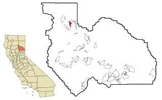
Hamilton Branch is a census-designated place (CDP) in Plumas County, California, United States. The population was 587 at the 2000 census.

Lake Almanor Country Club, California Census-designated place in California, United States

Lake Almanor Country Club is a census-designated place (CDP) in Plumas County, California, United States. The population was 419 at the 2010 census, down from 847 at the 2000 census. The ZIP code for the CDP is 96137.

Lake Almanor West, California Census-designated place in California, United States

Lake Almanor West is a census-designated place (CDP) in Plumas County, California, United States. The population was 270 at the 2010 census, down from 329 at the 2000 census.

Tobin, California Census-designated place in California, United States

Tobin is a census-designated place (CDP) in Plumas County, California, United States. The population was 12 at the 2010 census, up from 11 at the 2000 census.

Morada, California Census-designated place in California, United States

Morada is a census-designated place (CDP) in San Joaquin County, California, United States. The population was 3,166 at the 2020 census, down from 3,828 at the 2010 census.

Taft Mosswood, California Census-designated place in California, United States

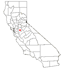
Taft Mosswood is a census-designated place (CDP) in San Joaquin County, California, United States. The population was 1,530 at the 2010 census, up from 1,388 at the 2000 census. It comprises an unincorporated "island" within the City of Stockton.

Twin Lakes, California Census-designated place in California, United States

Twin Lakes is a census-designated place (CDP) in Santa Cruz County, California, United States. The population is at an estimated 5,378 as of 2016 which is up by 461 in 2010.

Victory Lakes, New Jersey Census-designated place in New Jersey, United States

Victory Lakes is an unincorporated community and census-designated place (CDP) located within Monroe Township, in Gloucester County, New Jersey, United States. As of the 2010 United States Census, the CDP's population was 2,111.

Lake Wynonah is a census-designated place (CDP) in Schuylkill County, Pennsylvania, United States. The population was 1,961 at the 2000 census, and 2,640 at the 2010 census. Lake Wynonah is a gated community with two lakes, Fawn Lake and Lake Wynonah, and as of July 2008, there are over 1200 homes and 1500 members. It is in South Manheim and Wayne Townships.

East Wenatchee Bench, Washington Former CDP in Washington, United States

East Wenatchee Bench is a former census-designated place in Douglas County, Washington, United States. Most of the area has been annexed by the city of East Wenatchee. It was part of the Wenatchee–East Wenatchee Metropolitan Statistical Area. The population was 13,658 at the 2000 census, but it was no longer a CDP in the 2010 census.

Ames Lake, Washington Census-designated place in Washington, United States

Ames Lake is an unincorporated community and census-designated place (CDP) in King County, Washington, United States. The population was 1,486 at the 2010 census.

Lake Marcel-Stillwater, Washington Census-designated place in Washington, United States

Lake Marcel-Stillwater is a census-designated place (CDP) in King County, Washington, United States. The population was 1,277 at the 2010 census.

Lake Bosworth, Washington CDP in Washington, United States

Lake Bosworth is a census-designated place (CDP) in Snohomish County, Washington, United States. The population was 667 at the 2010 census.

Lake Roesiger, Washington CDP in Washington, United States

Lake Roesiger is a census-designated place (CDP) in Snohomish County, Washington, United States. The population was 503 at the 2010 census.

Three Lakes, Washington CDP in Washington, United States

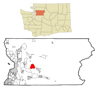
Three Lakes is a census-designated place (CDP) in Snohomish County, Washington, United States. The population was 3,184 at the 2010 census.

References

  1. U.S. Census Archived 2012-01-25 at the Wayback Machine
  2. "US Gazetteer files: 2010, 2000, and 1990". United States Census Bureau. 2011-02-12. Retrieved 2011-04-23.
  3. "Census of Population and Housing". Census.gov. Retrieved June 4, 2016.
  4. "2010 Census Interactive Population Search: CA - Lake Almanor Peninsula CDP". U.S. Census Bureau. Archived from the original on July 15, 2014. Retrieved July 12, 2014.
  5. "U.S. Census website". United States Census Bureau . Retrieved 2008-01-31.
  6. "Senators". State of California. Retrieved March 10, 2013.
  7. "Members Assembly". State of California. Retrieved March 2, 2013.
  8. "California's 1st Congressional District - Representatives & District Map". Civic Impulse, LLC. Retrieved March 3, 2013.