Lake Daylesford

Last updated

Lake Daylesford
Aerial panorama of Lake Daylesford.jpg
Aerial panorama of Lake Daylesford
Australia Victoria relief location map.jpg
Red pog.svg
Lake Daylesford
Australia relief map.jpg
Red pog.svg
Lake Daylesford
Location Daylesford, Victoria
Coordinates 37°20′50″S144°08′16″E / 37.34722°S 144.13778°E / -37.34722; 144.13778
Lake type Artificial lake
Primary inflows Wombat Creek
Primary outflows Molonglo River
Average depth2 m (6.6 ft)
Max. depth9 m (30 ft)
Surface elevation531 m (1,742 ft)
DamDaylesford Dam

Lake Daylesford is an artificial lake in the town of Daylesford, Victoria, Australia. It was completed in either 1927 or 1929 after many years of campaigning, beginning in 1893. [1] It was designed by Walter Burley Griffin, the American architect who won the competition to design the city of Canberra. [2] Lake Daylesford was formed when the dam wall was built across Wombat Creek above the Central Springs in 1929. The town wanted an ornamental body of water to beautify the scarred creek landscape. [3]

Contents

LAKE DAYLESFORD - panoramio.jpg

Site location and planting

Areas submerged by the lake included market gardens, several mineral springs, and the site of the former Chinese settlement, including a Joss house. [1] Walter Burley Griffin recommended native vegetation along the western side and the Progress Association and local schools helped plant European (Swedish) and native trees in other parts of the reserve.

Opening of the lake

On Thursday 17 April 1930, the streets of Daylesford were decorated with flags and decorations when the Governor, Lord Somers accompanied by Flight Lieut. Denny, arrived by car at 12.30 p.m. The Borough Band played selections outside the Town Hall, and the Boy Scouts under Scoutmaster Thorsen, were present. After inspecting the Scouts, Governor Somers was welcomed in the Town Hall by Borough Councillors. [4]

A lunch was held in the Rex Theatre and the tables were decorated with blue delphiniums, marigolds and autumn leaves. Palms and clusters of Aster viminalis (Easter daisies) added charm to the foyer and made a pretty setting. The Governor's table was decorated with autumn-tinted Virginia creeper leaves. [4]

After the lunch, the party left for the Wombat Hill Botanic Gardens, where the Governor expressed admiration for their "rare beauty". He was disappointed that he had not more time at his disposal to explore them more fully. [4]

On a raised platform at the lake bank, the Governor declared the lake open. A large crowd was around the banks and he was introduced by the Mayor (Cr Crockett). His Excellency said he "would like to think that the building of the lake had been delayed for 25 years so that he might be given the opportunity of opening it." The people of Daylesford and the Borough Council had shown a great spirit in developing the town in a period of depression. He had just seen a wonderful garden on the top of Wombat Hill and the view was magnificent. He had tasted four samples of the mineral water, and they were different from those he had tasted before, which as a rule were something like that which one preferred not to taste. Daylesford's however, were quite palatable. If he did not blow up on the way home he would take away a very pleasurable and lasting impression of Daylesford. The development of this great asset was of great value to the State. The people of the district had the opportunity of giving valuable service to the State and the Commonwealth. If they stood together, they would continue that same great service. Everything was in Daylesford's favor —a high elevation, beautiful scenery and there was an abundance of mineral water. Should the desire for progress be maintained he could see a future for Daylesford second to none, and as Governor of the State he was "pleased to identify myself with the movement". He hoped that the time would come, and not in the too distant future, when Daylesford would be covered with hydropaths. He declared the lake and springs open.

Opening of the bridge

At the new bridge the Governor praised the work which the Country Roads Board had done to develop the State. He had many opportunities of seeing the roads constructed by the Board, and it was pleasing to know of the co-operation between the Board and the Borough Council. This co-operation would be a great aid in the development of the springs, and of great benefit to the State. [4]

Friends of Lake Daylesford and developments

In the 1980s and the formation of the Friends of Lake Daylesford (FOLD) whose membership comprised local residents, particularly with properties adjacent to the lake reserve. The group were very active and maintained a close and cooperative relationship with the then Shire of Daylesford and Glenlyon. In 1990, working bees were conducted on the second Saturday of each month. [1]

In the 1980s and 1990s the level of the lake was lowered for a period of time to allow for works on the retaining wall. This gave the opportunity to remove rubbish which had accumulated in the lake since its creation. Member David Endacott was responsible for propagation of a range of native trees which members in turn planted in large numbers around the southern section of the lake. The extensive range of trees seen today resulted from this work.

Notes

  1. 1 2 3 "Community Spirit Inspired our Lake". 5 June 2020.
  2. "Lake Burley Griffin and Surrounding Parklands". National Capital Authority . Retrieved 1 June 2009.
  3. "Lake Daylesford Lookout".
  4. 1 2 3 4 "Lake Daylesford".

Related Research Articles

<span class="mw-page-title-main">Canberra</span> Capital city of Australia

Canberra is the capital city of Australia. Founded following the federation of the colonies of Australia as the seat of government for the new nation, it is Australia's largest inland city and the eighth-largest Australian city overall. The city is located at the northern end of the Australian Capital Territory at the northern tip of the Australian Alps, the country's highest mountain range. As of June 2023, Canberra's estimated population was 466,566.

<span class="mw-page-title-main">Walter Burley Griffin</span> American architect and landscape architect (1876–1937)

Walter Burley Griffin was an American architect and landscape architect. He designed Canberra, Australia's capital city, the New South Wales towns of Griffith and Leeton, and the Sydney suburb of Castlecrag.

<span class="mw-page-title-main">Government House, Canberra</span> Official residence of the Governor-General of Australia

Government House is the official residence of the governor-general of Australia. It is located in the suburb of Yarralumla, in the City of Canberra, in the Australian Capital Territory. The house is set amid 54 hectares of parkland. The house and associated grounds were added to the Commonwealth Heritage List on 22 June 2004.

The history of Canberra details the development of the city of Canberra from the time before European settlement to the city's planning by the Chicago architect Walter Burley Griffin in collaboration with Marion Mahony Griffin, and its subsequent development to the present day.

<span class="mw-page-title-main">Lake Burley Griffin</span> Man-made lake in Canberra, Australia

Lake Burley Griffin is an artificial lake in the centre of Canberra, Australian Capital Territory, Australia. It was completed in 1963 after the Molonglo River, which ran between the city centre and Parliamentary Triangle, was dammed. It is named after Walter Burley Griffin, the American architect who won the competition to design the city of Canberra.

<span class="mw-page-title-main">Yarralumla, Australian Capital Territory</span> Suburb of Canberra, Australia

Yarralumla is a large inner south suburb of Canberra, the capital city of Australia. Located approximately 3.5 km (2.2 mi) south-west of the city, Yarralumla extends along the south-west bank of Lake Burley Griffin from Scrivener Dam to Commonwealth Avenue.

<span class="mw-page-title-main">Capital Hill, Australian Capital Territory</span> City center and the location of Parliament House, Canberra, Australia

Capital Hill is the location of Parliament House, Canberra, Australian Capital Territory, at the south apex of the land axis of the Parliamentary Triangle.

<span class="mw-page-title-main">Barton, Australian Capital Territory</span> Suburb of Canberra, Australia

Barton is a suburb of Canberra, Australian Capital Territory, Australia. At the 2021 census, Barton had a population of 1,946 people.

<span class="mw-page-title-main">Old Parliament House, Canberra</span> Seat of the Parliament of Australia from 1927 to 1988

Old Parliament House, formerly known as the Provisional Parliament House, was the seat of the Parliament of Australia from 1927 to 1988. The building began operation on 9 May 1927 after Parliament's relocation from Melbourne, Victoria, to the new capital, Canberra, Australian Capital Territory. In 1988, the Commonwealth Parliament transferred to the new Parliament House on Capital Hill. It also serves as a venue for temporary exhibitions, lectures and concerts. Old Parliament House is, looking across Lake Burley Griffin, situated in front of Parliament House and in line with the Australian War Memorial.

<span class="mw-page-title-main">Daylesford, Victoria</span> Town in Victoria, Australia

Daylesford is a spa town located in the foothills of the Great Dividing Range, within the Shire of Hepburn, Victoria, Australia, approximately 114 kilometres north-west of Melbourne. First established in 1852 as a gold-mining town, today Daylesford has a population of 2,781 as of the 2021 census.

<span class="mw-page-title-main">Parliamentary Triangle, Canberra</span>

The National Triangle, which is referred to as the Parliamentary Triangle, is the ceremonial precinct of Canberra, containing some of Australia's most significant buildings. The National Triangle is formed by Commonwealth, Kings and Constitution Avenues. Buildings within the National Triangle have been located and designed intentionally for visual effect, and those of national significance are popular tourist attractions.

<span class="mw-page-title-main">Telopea Park</span>

Telopea Park is one of the oldest parks in Canberra, Australia. The name of the park is from Walter Burley Griffin's original plan for Canberra where he planned Telopea Park at the end of Sydney Avenue. The park is named after the floral emblem of New South Wales, also known as the Waratah. Griffin planned that the state capital city avenues were terminated with a park named after the generic botanical name for a native plant from that particular state. The park covers 0.079 km2.

<span class="mw-page-title-main">Lennox Gardens</span>

Lennox Gardens, a park in Canberra, Australia, lying on the south side of Lake Burley Griffin, close to Commonwealth Avenue Bridge and Albert Hall in the suburb of Yarralumla. Before the construction of Lake Burley Griffin a road ran through the present garden, this road being one of two main crossing points across the Molonglo River. The name of the road was Lennox Crossing from which the present garden takes its name. The northern segment of the road is still present on Acton peninsula. The garden was officially named in 1963. Lennox Crossing was named after David Lennox, an early bridge builder in NSW and Victoria.

The history of the Australian Capital Territory (ACT) as a separate administrative division began in 1911, when it was transferred from New South Wales to the Australian federal government. The territory contains Australia's capital city Canberra and various smaller settlements. Until 1989, it also administered the Jervis Bay Territory, a small coastal region.

<span class="mw-page-title-main">Springbank Island</span>

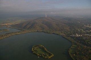
Springbank Island is an island located on Lake Burley Griffin in Canberra, Australian Capital Territory. Springbank Island is named after a former agricultural property that was partially submerged to create Lake Burley Griffin. An elevated part of the former property now comprises the island.

<span class="mw-page-title-main">Scrivener Dam</span> Dam in Canberra, ACT

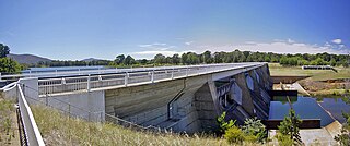
Scrivener Dam is a concrete gravity dam that impounds the Molonglo River in Canberra, Australian Capital Territory. The dam creates Lake Burley Griffin, which was established for recreational and ornamental purposes. Named in honour of surveyor Charles Scrivener, the dam was officially inaugurated on 20 September 1963 and the official filling of the lake commemorated on 17 October 1964 by the Prime Minister, Robert Menzies.

<span class="mw-page-title-main">History of Lake Burley Griffin</span> Notable events in the history of the artificial water body in Canberra

The history of Lake Burley Griffin, an artificial body of water in Canberra, the capital of Australia, is highly complex. Following its initial design in the 1910s, extensive political disputes occurred until it was finally built in the 1960s.

<span class="mw-page-title-main">Wombat State Forest</span> Protected area in Victoria, Australia

The Wombat State Forest is located 50 kilometres (31 mi) west of Melbourne, Victoria, Australia, between Woodend and Daylesford, at the Great Dividing Range. The forest is approximately 70,000 hectares in size and sits upon Ordovician or Cenozoic sediments. The Bullarook Wombat State Forest was proclaimed in 1871.

The National Capital Authority (NCA) is a statutory authority of the Australian Government that was established to manage the Commonwealth's interest in the planning and development of Canberra as the capital city of Australia.

<span class="mw-page-title-main">Walter Burley Griffin Incinerator, Willoughby</span> Historic site in New South Wales, Australia

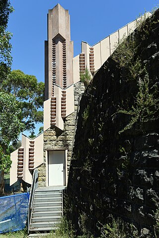
The Walter Burley Griffin Incinerator is a heritage-listed former incinerator and now art gallery, artists studios and public recreation area at 2 Small Street, Willoughby, City of Willoughby, Sydney, New South Wales, Australia. It was designed in partnership between Walter Burley Griffin and Eric Nicholls and built from 1933 to 1934 by Reverberatory Incinerator and Engineering Company and Nisson Leonard-Kanevsky. It is also known as Willoughby Municipal Incinerator. The property is owned by the Willoughby City Council. It was added to the New South Wales State Heritage Register on 2 April 1999.

References