
The Allegheny River is a 325-mile-long (523 km) headwater stream of the Ohio River that is located in western Pennsylvania and New York in the United States. It runs from its headwaters just below the middle of Pennsylvania's northern border, northwesterly into New York, then in a zigzag southwesterly across the border and through Western Pennsylvania to join the Monongahela River at the Forks of the Ohio at Point State Park in Downtown Pittsburgh, Pennsylvania.

New Britain Township is a township in Bucks County, Pennsylvania, United States. The population was 11,070 at the 2010 census.

The East Branch Delaware River is one of two branches that form the Delaware River. It is approximately 75 mi (121 km) long, and flows through the U.S. state of New York. It winds through a mountainous area on the southwestern edge of Catskill Park in the Catskill Mountains for most of its course, before joining the West Branch along the northeast border of Pennsylvania with New York. Much of it is paralleled by State Route 30.

The Feather River is the principal tributary of the Sacramento River, in the Sacramento Valley of Northern California. The river's main stem is about 73 miles (117 km) long. Its length to its most distant headwater tributary is just over 210 miles (340 km). The main stem Feather River begins in Lake Oroville, where its four long tributary forks join—the South Fork, Middle Fork, North Fork, and West Branch Feather Rivers. These and other tributaries drain part of the northern Sierra Nevada, and the extreme southern Cascades, as well as a small portion of the Sacramento Valley. The total drainage basin is about 6,200 square miles (16,000 km2), with approximately 3,604 square miles (9,330 km2) above Lake Oroville.
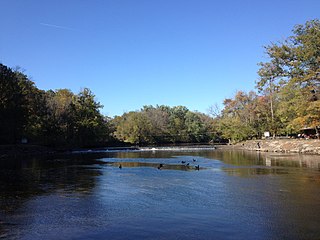
Neshaminy Creek is a 40.7-mile-long (65.5 km) stream that runs entirely through Bucks County, Pennsylvania, rising south of the borough of Chalfont, where its north and west branches join. Neshaminy Creek flows southeast toward Bristol Township and Bensalem Township to its confluence with the Delaware River.

Nockamixon State Park is a Pennsylvania state park on 5,283 acres (2,138 ha) in Bedminster and Haycock Townships in northern Bucks County, Pennsylvania, in the United States. The park is one of the most popular in southeastern Pennsylvania, with most tourists visiting in the summer months.

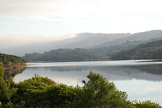
The San Luis Reservoir is an artificial lake on San Luis Creek in the eastern slopes of the Diablo Range of Merced County, California, approximately 12 mi (19 km) west of Los Banos on State Route 152, which crosses Pacheco Pass and runs along its north shore. It is the fifth largest reservoir in California. The reservoir stores water taken from the San Joaquin-Sacramento River Delta. Water is pumped uphill into the reservoir from the O'Neill Forebay which is fed by the California Aqueduct and is released back into the forebay to continue downstream along the aqueduct as needed for farm irrigation and other uses. Depending on water levels, the reservoir is approximately nine miles (14 km) long from north to south at its longest point, and five miles (8 km) wide. At the eastern end of the reservoir is the San Luis Dam, the fourth largest embankment dam in the United States, which allows for a total capacity of 2,041,000 acre-feet (2,518,000 dam3). Pacheco State Park lies along its western shores.

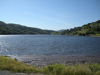
Peace Valley Park is a 1,500 acre (6 km²) park located near Doylestown, Pennsylvania. It is part of the Bucks County Park System. The park surrounds Lake Galena, a 365-acre (1.5 km2) lake created by the damming of the north branch of the Neshaminy Creek.
Crystal Springs Reservoir is a pair of artificial lakes located in the northern Santa Cruz Mountains of San Mateo County, California, situated in the rift valley created by the San Andreas Fault just to the west of the cities of San Mateo and Hillsborough, and I-280. The lakes are part of the San Mateo Creek watershed.
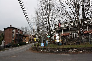
Point Pleasant is an unincorporated community in Tinicum and Plumstead Townships of Bucks County, Pennsylvania, United States. It lies on both sides of Tohickon Creek by the creek's confluence with the Delaware River; the creek is the dividing line between the townships. The ZIP code for the post office in Point Pleasant is 18950.

Penns Valley is an eroded anticlinal valley of the Pennsylvania ridge and valley geologic region of the Appalachian Mountain range. The valley is located in southern Centre County, Pennsylvania. Along with the Nittany Valley to the north and east, it is part of the larger Nittany Anticlinorium. It is bordered by Mount Nittany to the north, the Seven Mountains range to the south, and connects to the larger Nittany Valley to the west. There are two smaller subordinate valleys typically associated with the greater valley: Georges Valley in the south, separated by Egg Hill, and Brush Valley in the north, separated by Brush Mountain.

Uvas Reservoir is an artificial lake located west of Morgan Hill, California, in the United States. The reservoir is surrounded by a 626-acre (253 ha) park managed by the Santa Clara County Parks and Recreation Department. The park provides limited fishing ("catch-and-release"), picnicking, and hiking activities. Boating is not permitted in the reservoir.
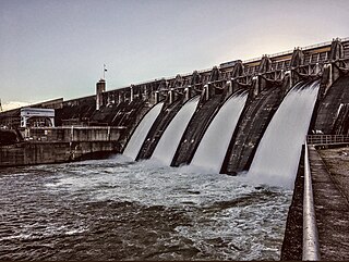
Cherokee Dam is a hydroelectric dam located on the Holston River in Grainger County and Jefferson County, Tennessee, in the southeastern United States. The dam is operated and maintained by the Tennessee Valley Authority, which built the dam in the early 1940s to help meet urgent demands for energy at the outbreak of World War II. Cherokee Dam is 175 feet (53 m) high and impounds the 28,780-acre (11,650 ha) Cherokee Lake. It has a generating capacity of 136 megawatts. The dam was named for the Cherokee, a Native American tribe that controlled much of East Tennessee when the first European settlers arrived in the mid-18th century.
Chesbro Reservoir is an artificial lake located three miles (5 km) west of Morgan Hill, California, in the United States. A 232-acre (94 ha) county park surrounds the reservoir and provides limited fishing ("catch-and-release"), picnicking, and hiking activities. Swimming and boating are not permitted in the reservoir.
Ironworks Creek is a tributary of Mill Creek in Northampton Township, Bucks County, Pennsylvania, part of the Neshaminy Creek, and of the Delaware River watersheds.
Robin Run is a dammed headwater major tributary of the Delaware River with a drainage area of 22.69 square miles that is 1.69 miles north 1.69 miles north of Mill Creek's Confluence with the Neshaminy Creek on the border of Buckingham and Wrightstown Townships), The headwaters originate in Buckingham Township, Bucks County, Pennsylvania and the stream flows generally southeast to its confluence with Mill Creek in Wrightstown Township.
North Branch Neshaminy Creek is one of two main branches of the Neshaminy Creek, the other being the West Branch. Rising in Plumstead Township, Bucks County, Pennsylvania, passing through the Peace Valley Park as Lake Galena, then meeting with the West Branch forming the main branch of the Neshaminy.

The North Penn Water Authority (NPWA) is a water utility providing drinking water to portions of Bucks and Montgomery counties in the U.S. state of Pennsylvania, centered around the North Penn Valley region. The NPWA is a municipal authority that is owned by the municipalities that is serves. The NPWA provides drinking water to over 34,000 customers in 20 municipalities. The authority was formed in 1964 and has grown over the years.
The North Wales Water Authority (NWWA) is a water utility and municipal authority providing drinking water to portions of Bucks and Montgomery counties in the U.S. state of Pennsylvania, centered around the borough of North Wales. The authority serves over 25,000 customers in seven municipalities and also provides wholesale water to other water authorities in Bucks and Montgomery counties. The NWWA was established by the borough of North Wales in 1951 and has expanded its service area since then.


