
Marion County is located in the northern portion of the U.S. state of Florida. As of the 2020 census, the population was 375,908. Its county seat is Ocala.
Citrus County is a county located on the west central coast of the U.S. state of Florida. As of the 2020 census, the population was 153,843. Its county seat is Inverness, and its largest community is Homosassa Springs.

Pasco County is located on the west central coast of the U.S. state of Florida. According to the 2020 census, the population was 561,691. Its county seat is Dade City, and its largest city is Zephyrhills. The county is named after Samuel Pasco.

Seminole County is a county located in the central portion of the U.S. state of Florida. As of the 2020 census, the population was 470,856, making it the 13th-most populated county in Florida. Its county seat and largest city is Sanford. Seminole County is part of the Orlando-Kissimmee-Sanford, Florida Metropolitan Statistical Area.
Sumter County is a county located in the central portion of the U.S. state of Florida. As of the 2020 census, the population is 129,752. It has the oldest median age of any US county and the highest percentage of residents aged 65 and older—at 55.6% in 2014-2018. Its county seat is Bushnell, and the largest community is The Villages.
Volusia County is located in the east-central part of the U.S. state of Florida between the St. Johns River and the Atlantic Ocean. As of the 2020 census, the county was home to 553,543 people, an increase of 11.9% from the 2010 census. It was founded on December 29, 1854, from part of Orange County, and was named for the community of Volusia, located in northwestern Volusia County. Its first county seat was Enterprise. Since 1887, its county seat has been DeLand.

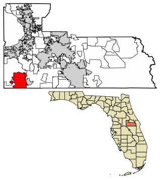
Four Corners, also known as Citrus Ridge, is an unincorporated suburban community and census-designated place (CDP) in the U.S. state of Florida, located at the borders of Lake, Orange, Osceola, and Polk counties. Its population was 56,381 at the 2020 census, up from 26,116 at the 2010 census.
Bay Lake is a city in Orange County, Florida, United States. The population was 29 at the 2020 census. It is named after a lake that lies east of the Magic Kingdom. All four of the Walt Disney World Resort theme parks, and one of Walt Disney World's two water parks, are in Bay Lake, though all Disney parks in the region have mailing addresses in nearby Lake Buena Vista.

Maitland is a suburban city in Orange County, Florida, United States, part of the Greater Orlando area. The population was 19,543 at the 2020 census. The area's history is exhibited at the Maitland Historical Museum; the city also hosts the Maitland Art Center, as well as notable examples of Mayan Revival architecture and Fantasy architecture, the Maitland Telephone Museum, and the William H. Waterhouse House Museum. A SunRail station is located in Maitland on Highway 17-92. The city is named for Fort Maitland.
Ocoee is a city in Orange County, Florida, United States. According to the 2019 US Census population estimate, the city had a population of 48,263. It is part of the Orlando–Kissimmee–Sanford, Florida Metropolitan Statistical Area.

Sanford is a city in the U.S. state of Florida and the county seat of Seminole County. It is located in Central Florida and its population was 61,051 as of the 2020 census.
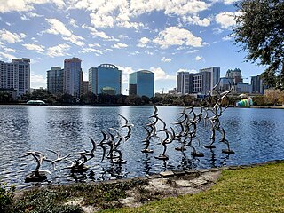
Downtown Orlando is the historic core and central business district of Orlando, Florida, United States. It is bordered by Marks Street in the north, Mills Avenue in the east, Orange Blossom Trail in the west, and Kaley Avenue in the south. There are several distinct neighborhoods in downtown; "North Quarter" to the north, "Lake Eola Heights Historic District" just north of Lake Eola, "South Eola" contains Lake Eola Park and continues to the east and south of Lake Eola, "Thornton Park" in the east, "Parramore" in the west, "Lake Cherokee Historic District" to the south, and the "Central Business District" between Colonial Drive and Lake Lucerne in the center. In 2010, the estimated population of downtown was 18,731. The daytime population was estimated to be 65,000. The 5-mile radius population of downtown is 273,335.
Lake Buckeye, a natural freshwater lake in eastern Winter Haven, Florida, United States, is somewhat oval in shape. This lake has a 70.24-acre (284,300 m2) surface area. This lake is bordered on the west side by residences and along most of the north and east by woods. Buckeye Road borders the lake on the south and part of the southeast. This lake is very swamplike along its northern, eastern and southeastern shores. It has a number of floating islands along these areas and at least one on its west shore.

Lake Dot or is a 5.42-acre (21,900 m2) natural freshwater lake in central Orlando, Florida. Lake Dot, an almost round lake, is in the Lake Dot neighborhood of the city. It is in a completely urbanized area with homes and businesses surrounding it. A fountain is near the center of this lake. The north side of the lake is bounded by Colonial Drive, a very busy thoroughfare. It appears a small portion of the lake was filled in to allow Colonial to run in a straight line. On the south is Concord Street and on the east and west sides, Lake Dot is bordered by Lake Dot Circle.
Lake Bennet, also spelled Bennett and also known as Lake Blanchard, is a somewhat kidney-shaped natural freshwater lake in Orange County, Florida. Florida State Road 50 travels over the south end of this lake. On the lake's northeast is the Lake Bennett Health & Rehabilitation Center. This lake is surrounded by commercial properties.
Lake Whippoorill, also known as Barton Lake, is an oblong freshwater lake in the community of Lake Hart, which is in Orange County, Florida. Some development surrounds this lake and on the west side it is bordered by the Lake Whippoorill Kampground of America. Just to the north and west is the Central Florida GreeneWay,. A canal, probably not even traversable by even a very small boat, connects Lake Whippoorill to Lake Hart, to the east.
Lake Roberts, just south of Florida State Road 429, is a natural freshwater lake on the west side of Orlando, Florida, in Orange County, Florida. This lake is almost entirely surrounded by residential housing. It has a swampy area on its northeast and the only public access is along a short stretch of McKinnon Road that runs along a very small part of the southeast shore of the lake. As that stretch is brushy it would probably even be unsuitable for fishing.
Lake Sherwood, just southeast of Florida State Road 429, is a natural freshwater lake west of Orlando, Florida, in Orange County, Florida. This lake is surrounded by residential housing and retail establishments. Two roads cross the lake via bridges. Colonial Drive, an east to west street, crosses its middle and Florida State Road 429 cuts across the southern portion of the lake. Much of the lake shore is swampy. Lake Sherwood is listed in the Orange County Wateratlas as a private lake; there is no public access along its shores.


