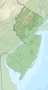
Sussex County is the northernmost county in the U.S. state of New Jersey. Its county seat is Newton. It is part of the New York metropolitan area and is part of New Jersey's Skylands Region. As of the 2020 census, the county was the state's 17th-most-populous county, with a population of 144,221, a decrease of 5,044 (−3.4%) from the 2010 census count of 149,265, which in turn reflected an increase of 5,099 (+3.5%) over the 144,166 persons at the 2000 census. Based on 2020 census data, Vernon Township was the county's largest in both population and area, with a population of 22,358 and covering an area of 70.59 square miles (182.8 km2). The county is part of the North Jersey region of the state.

The Musconetcong River is a 45.7-mile-long (73.5 km) tributary of the Delaware River in northwestern New Jersey in the United States. It flows through the rural mountainous country of northwestern New Jersey. The name derives from the Lenape words moschakgeu meaning "clear" and hannek meaning "stream". Part of it is a National Wild and Scenic River.

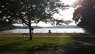
Lake Hopatcong is the largest freshwater body in New Jersey, United States, about 4 square miles (10 km2) in area. Located 30 miles (48 km) from the Delaware River and 40 miles (64 km) from Manhattan, New York City, the lake forms part of the border between Sussex and Morris counties in the state's northern highlands region.
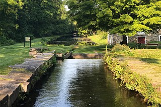
The Morris Canal (1829–1924) was a 107-mile (172 km) common carrier anthracite coal canal across northern New Jersey that connected the two industrial canals in Easton, Pennsylvania across the Delaware River from its western terminus at Phillipsburg, New Jersey to New York Harbor and New York City through its eastern terminals in Newark and on the Hudson River in Jersey City. The canal was sometimes called the Morris and Essex Canal, in error, due to confusion with the nearby and unrelated Morris and Essex Railroad.

Otisco Lake is the easternmost of New York's eleven Finger Lakes. The 2,048-acre (8.29 km2) lake is located in Onondaga County, southwest of the city of Syracuse.

Merrill Creek Reservoir, located in Harmony Township, New Jersey in central Warren County, New Jersey, is a 650-acre (260 ha) artificial lake designed to hold 15 billion gallons of water that is surrounded by 290 acres (120 ha) of protected woodland and fields. These lands are themselves part of 2,000 acres (8.1 km2) of open spaces.

The Paulins Kill is a 41.6-mile (66.9 km) tributary of the Delaware River in northwestern New Jersey in the United States. With a long-term median flow rate of 76 cubic feet of water per second (2.15 m3/s), it is New Jersey's third-largest contributor to the Delaware River, behind the Musconetcong River and Maurice River. The river drains an area of 176.85 square miles (458.0 km2) across portions of Sussex and Warren counties and 11 municipalities. It flows north from its source near Newton, and then turns southwest. The river sits in the Ridge and Valley geophysical province.

Papakating Creek is a 20.1-mile-long (32.3 km) tributary of the Wallkill River located in Frankford and Wantage townships in Sussex County, New Jersey in the United States. The creek rises in a small swamp located beneath the eastern face of Kittatinny Mountain in Frankford and its waters join the Wallkill to the east of Sussex borough.

Rondout Reservoir is part of New York City's water supply network. It is located 75 miles (121 km) northwest of the city in the Catskill Mountains, near the southern end of Catskill Park, split between the towns of Wawarsing in Ulster County and Neversink in Sullivan County. It is the central collection point for the city's Delaware System, which provides half its daily consumption.
Swartswood State Park is a 3,460-acre (14.0 km2) protected area located in the Swartswood section of Stillwater and Hampton townships in Sussex County, New Jersey, in the United States. Established in 1915 by the state's Forest Park Reservation Commission, it was the first state park established by the state of New Jersey for the purposes of recreation at the state's third-largest freshwater lake. Today, Swartswood State Park is operated and maintained by the New Jersey Division of Parks and Forestry.
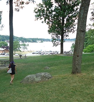
Hopatcong State Park is a state park in the Landing section of Roxbury Township, New Jersey, United States. Operated and maintained by the New Jersey Division of Parks and Forestry, the park consists of two parcels of land: one that encompasses Lake Hopatcong and some of its southwestern shore, and another that encompasses Lake Musconetcong about one mile to the west-southwest.

The Skylands Region is a region of New Jersey located in the northern and central parts of the state. It is one of seven tourism regions established by the New Jersey State Department of Tourism; the others are Gateway Region, Greater Atlantic City Region, the Southern Shore Region, the Delaware River Region, the Shore Region, and the Central Jersey Region.
Lake Gilead is a 116-acre (0.47 km2) controlled lake located in Carmel Hamlet in Putnam County, New York. Originally known as Dean's Pond, it is 0.8 miles long, has a mean depth of 43 feet (13 m), and a maximum depth of approximately 120 feet (37 m). The lake is located within the lower Hudson River basin in the Croton River watershed.

Mansfield Hollow Lake is a reservoir resting on the border of Windham County and Tolland County, Connecticut. The reservoir provides drinking water for Willimantic and helps control flooding in the 159-square-mile Thames River watershed. It was created by the Mansfield Hollow Dam and is entirely contained within Mansfield Hollow State Park and the Mansfield Hollow Wildlife Area. Designed and constructed by the United States Army Corps of Engineers, the dam substantially reduces flooding along the Quinebaug, Shetucket, and Thames rivers. Construction of the project began in 1949 with completion in 1952 at a cost of US$6.5 million. The Mansfield Hollow reservoir is located within the Shetucket River Watershed and is part of the Thames River Basin. Access to the site is available from US Route 6 and State Route 195. The damsite, covering an area of 25 acres (10 ha), was listed on the National Register of Historic Places in 2003.

The Los Vaqueros Reservoir and watershed is located in the northern Diablo Range, within northeastern Contra Costa County, northern California. It was completed by the Contra Costa Water District (CCWD) in 1998 to improve the quality of drinking water for its 550,000 customers in Central and Eastern Contra Costa County. The reservoir is accessible via Vasco Road, a road which connects Brentwood and Livermore.

Little Seneca Lake is a reservoir located near the Boyds community in Montgomery County, Maryland.

Neepaulakating Creek is a 2.4-mile long (3.8 km) tributary of Papakating Creek in Wantage Township in Sussex County, New Jersey in the United States. It is one of three streams feeding the Papakating Creek, a major contributor to the Wallkill River. Although the stream was dammed in the 1950s to create Lake Neepaulin as the focal point of a private residential development, the stream did not receive a name until 2002. Residents chose a name that combined elements of the names "Neepaulin" and "Papakating", and submitted a proposal to the United States Board of Geographic Names. The name was approved in 2004.

Lake Neepaulin is a small man-made freshwater lake located in Wantage Township in Sussex County, New Jersey in the United States. Located in the watershed of Papakating Creek, a tributary of the Wallkill River, the lake was created in the 1950s by damming an unnamed mountain stream as the feature of a private residential development. The stream, now known as Neepaulakating Creek, did not receive a name until 2002.
Cuba Lake is a 454-acre (1.84 km2) reservoir in Allegany and Cattaraugus counties, New York.