Lake Sherwood, California

Last updated

Lake Sherwood, California
Lake Sherwood.jpg
Lake Sherwood and the Santa Monica Mountains
Ventura County California Incorporated and Unincorporated areas Lake Sherwood Highlighted 0639735.svg
Location of Lake Sherwood in Ventura County, California.
USA California location map.svg
Red pog.svg
Lake Sherwood, California
Location within the state of California
Usa edcp location map.svg
Red pog.svg
Lake Sherwood, California
Lake Sherwood, California (the United States)
Coordinates: 34°07′34″N118°53′17″W / 34.12611°N 118.88806°W / 34.12611; -118.88806
Country United States
State California
County Ventura
Area
[1]
  Total3.323 sq mi (8.607 km2)
  Land3.135 sq mi (8.121 km2)
  Water0.188 sq mi (0.486 km2)  5.65%
Elevation
[2]
1,194 ft (364 m)
Population
 (2020) [3]
  Total1,759
  Density530/sq mi (200/km2)
Time zone UTC-8 (Pacific (PST))
  Summer (DST) UTC-7 (PDT)
ZIP codes
91361
Area code 805
FIPS code 06-39735
GNIS feature ID2585428
U.S. Geological Survey Geographic Names Information System: Lake Sherwood, California

Lake Sherwood is an unincorporated community in the Santa Monica Mountains, in Ventura County, California overlooking Lake Sherwood reservoir. It is a body contact lake, swimming, fishing, SUP and boating allowed, located south of the Conejo Valley and city of Thousand Oaks, and west of Westlake Village. The lake is naturally fed by thousand of acres of open-space, watershed mountains and natural springs.

Contents

While homes have been around the lake since the reservoir was created by the construction of Sherwood Dam in 1901, the community expanded with the development of the Sherwood Country Club golf course surrounded by luxury homes.

The ZIP Code is 91361, and the community is inside area code 805. The population was 1,759 at the 2020 census. For statistical purposes, the United States Census Bureau has defined Lake Sherwood as a census-designated place (CDP). [2] The census definition of the area may not precisely correspond to local understanding of the area with the same name.

Geography

Lake Sherwood was part of Rancho El Conejo, owned by Don Jose de la Guerra y Noriega, founder of the prominent Guerra family of California. Jose de la Guerra y Noriega (cropped).jpg
Lake Sherwood was part of Rancho El Conejo, owned by Don José de la Guerra y Noriega, founder of the prominent Guerra family of California.

According to the United States Census Bureau, the CDP covers an area of 3.3 square miles (8.6 km2), 3.1 square miles (8.1 km2) of it is land and 0.2 square miles (0.5 km2) of it (5.65%) is water.

Physical character

Lake Sherwood has approximately 660 residences and consists of a guard-gated golf-club community, three electronic-gated communities, and lake-view homes along Lake Sherwood Drive. The area is almost completely residential, most residents using neighboring Thousand Oaks, Westlake Village, or Agoura Hills for commercial needs.

Demographics

Historical population
CensusPop.Note
2010 1,527
2020 1,75915.2%
U.S. Decennial Census [4]

The 2010 United States Census [5] reported that Lake Sherwood had a population of 1,527. The population density was 459.5 inhabitants per square mile (177.4/km2). The racial makeup of Lake Sherwood was 1,368 (89.6%) White, 5 (0.3%) African American, 1 (0.1%) Native American, 101 (6.6%) Asian, 0 (0.0%) Pacific Islander, 9 (0.6%) from other races, and 43 (2.8%) from two or more races. Hispanic or Latino of any race were 52 persons (3.4%).

The Census reported that all residents lived in single-family households. There were 558 households, out of which 194 (34.8%) had children under the age of 18 living in them, 429 (76.9%) were opposite-sex married couples living together, 25 (4.5%) had a female householder with no husband present, 18 (3.2%) had a male householder with no wife present. There were 12 (2.2%) unmarried opposite-sex partnerships, and 4 (0.7%) same-sex married couples or partnerships. 72 households (12.9%) were made up of individuals, and 32 (5.7%) had someone living alone who was 65 years of age or older. The average household size was 2.74. There were 472 families (84.6% of all households); the average family size was 2.96.

The population is spread out, with 368 people (24.1%) under the age of 18, 92 people (6.0%) aged 18 to 24, 198 people (13.0%) aged 25 to 44, 623 people (40.8%) aged 45 to 64, and 246 people (16.1%) who were 65 years of age or older. The median age was 49.0 years. For every 100 females, there were 96.3 males. For every 100 females age 18 and over, there were 95.1 males.

There were 593 housing units at an average density of 178.4 per square mile (68.9/km2), of which 520 (93.2%) were owner-occupied, and 38 (6.8%) were occupied by renters. The homeowner vacancy rate was 2.4%; the rental vacancy rate was 7.3%. 1,418 people (92.9% of the population) lived in owner-occupied housing units and 109 people (7.1%) lived in rental housing units.

Education

The area is served by the Conejo Valley Unified School District. Students attend Westlake Elementary, Colina Middle School, and Westlake High School.

Notable people

Among the notable residents are hockey great Wayne Gretzky, who lived in a Georgian-style estate designed by fellow Canadian, Richard Landry. Gretzky sold the estate in 2007 for 18.5 million to another sports-star, baseball's Lenny Dykstra and moved to a slightly less extravagant mansion in the community. Since then, Dykstra's financial and legal problems forced him to sell the estate to a private individual and move away from the community. Dykstra declared bankruptcy, causing him to lose the property to foreclosure and in 2018 Gretzky repurchased the same property that he previously sold to Dykstra. [6] Singer Paul Anka moved to Lake Sherwood in 2007 and owns multiple properties in the exclusive neighborhood. Tom Petty lived in a lakefront retreat that was originally built in 1931. Producer/Author/Journalist Larry Garrison resides with his wife. The tennis legend Pete Sampras and his wife, actress Bridgette Wilson, built a very large, modern, hilltop estate they have since moved from the house. Britney Spears moved to the community in 2011 but recently moved into nearby Hidden Valley. Many other famous inhabitants own property in the community, however, they are only part-time residents and use their estates as a second home or as a retreat. Sylvester Stallone owned a lakefront hideaway that was featured in the film American Pie. Also, William Randolph Hearst, who was one of the first famous residents in the area and owned property around the lake, used his estate as a vacation getaway during the 1920s and 1930s.

Motion picture and television location

Lake Sherwood and Portero Rd. from Thousand Oaks SherwoodAerial.jpg
Lake Sherwood and Portero Rd. from Thousand Oaks
Sherwood Dam, Lake Sherwood, and surrounding community Sherwood Dam & Lake Sherwood.JPG
Sherwood Dam, Lake Sherwood, and surrounding community

Lake Sherwood lies just west of several major movie ranches and has frequently been used as a filming location for television shows like The Dukes of Hazzard , The Rockford Files , and Little House on the Prairie .

Lake Sherwood was named from being the location for Sherwood Forest in the 1922 film, Robin Hood , starring Douglas Fairbanks. [7] The 1938 film, The Adventures of Robin Hood , starring Errol Flynn, also had a single scene shot on location at "Sherwood Forest".

A mock cliff was constructed for several film serials, the lake was often used for motorboat chases and bordering forests were used for Tarzan and Jungle Jim films, and The Tiger Woman . [8] A full scale Tibetan village was built for Lost Horizon , [9] an Italian village for Blake Edwards's What Did You Do in the War, Daddy? (1966) and an alien village for Jonathan Frakes's Star Trek: Insurrection (1998). [10]

The film Bridesmaids (2011) was filmed in the community. The Sherwood Country Club was prominently featured in the pre-wedding scenes.

Filmography

Films shot in Lake Sherwood include: [11] [12]

See also

Related Research Articles

<span class="mw-page-title-main">Oscoda, Michigan</span> Census-designated place & unincorporated community in Michigan, United States

Oscoda is an unincorporated community and census-designated place (CDP) in Iosco County in the U.S. state of Michigan. The CDP had a population of 916 at the 2020 census. The community is located within Au Sable Township and Oscoda Township at the mouth of the Au Sable River along Lake Huron.

<span class="mw-page-title-main">Willow, Alaska</span> CDP in Alaska, United States

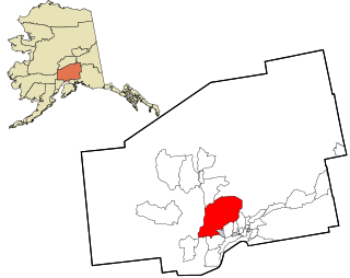
Willow is a census-designated place (CDP) in the Matanuska-Susitna Borough in the U.S. state of Alaska. Located 26 miles northwest from Wasilla along the George Parks Highway, it is part of the Anchorage, Alaska Metropolitan Statistical Area. At the 2020 census the population was 2,196, up from 2,102 in 2010.

<span class="mw-page-title-main">Lake Arrowhead, California</span> Census-designated place in California, United States

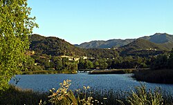
Lake Arrowhead is an unincorporated community and a census-designated place (CDP) in the San Bernardino Mountains of San Bernardino County, California, surrounded by the San Bernardino National Forest, and surrounding the eponymous Lake Arrowhead Reservoir. Lake Arrowhead is located 13 miles north east of the San Bernardino city limits. The population of the CDP was estimated at 12,424 in the 2010 census. It was formerly called "Little Bear Lake", until around 1920, when a group from Los Angeles, the Arrowhead Lake Company, bought the lake and the land surrounding it, and changed its name to Arrowhead Lake.

<span class="mw-page-title-main">Belvedere Park, Georgia</span> Place in Georgia, United States

Belvedere Park is an unincorporated community and census-designated place (CDP) in DeKalb County, Georgia, United States. The population was 15,113 at the 2020 census.

<span class="mw-page-title-main">Candler-McAfee, Georgia</span> Place in Georgia, United States

Candler-McAfee is an unincorporated community and census-designated place (CDP) in DeKalb County, Georgia, United States. It is located east of Atlanta approximately 10 miles (16 km) east of Downtown Atlanta and to the south of Decatur, Georgia The population was 23,025 at the 2010 census.

<span class="mw-page-title-main">Indian River, Michigan</span> Census-designated place & unincorporated community in Michigan, United States

Indian River is an unincorporated community and census-designated place (CDP) in Cheboygan County in the U.S. state of Michigan. The population was 1,950 at the 2020 census. The CDP is located in Tuscarora Township between Burt Lake and Mullett Lake.

<span class="mw-page-title-main">Westlake Village, California</span> City in California, United States

Westlake Village is a city in Los Angeles County on its western border with Ventura County. It incorporated in 1981 becoming the 82nd municipality of Los Angeles County. The population of the city was 8,029 at the 2020 census, down from 8,270 at the 2010 census.

<span class="mw-page-title-main">Michigamme, Michigan</span> Census-designated place & unincorporated community in Michigan, United States

Michigamme is an unincorporated community in Marquette County in the U.S. state of Michigan. It is located within Michigamme Township on the north shores of Lake Michigamme. For statistical purposes, the United States Census Bureau has defined Michigamme as a census-designated place (CDP). The CDP had a population of 255 at the 2020 census.

<span class="mw-page-title-main">Spanish Lake, Missouri</span> Census-designated place in Missouri, United States

Spanish Lake is a census-designated place (CDP) in St. Louis County, Missouri, United States. The population was 18,413 at the 2020 census.

<span class="mw-page-title-main">Country Lake Estates, New Jersey</span> Populated place in Burlington County, New Jersey, US

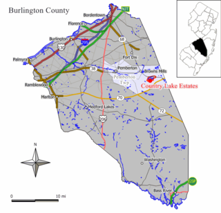
Country Lake Estates is an unincorporated community and census-designated place (CDP) located within Pemberton Township, in Burlington County, in the U.S. state of New Jersey. As of the 2010 United States Census, the CDP's population was 3,943.

<span class="mw-page-title-main">Presidential Lakes Estates, New Jersey</span> Populated place in Burlington County, New Jersey, US

Presidential Lakes Estates is an unincorporated community and census-designated place (CDP) located within Pemberton Township, in Burlington County, in the U.S. state of New Jersey. As of the 2010 United States Census, the CDP's population was 2,365.

<span class="mw-page-title-main">Cliffwood Beach, New Jersey</span> Populated place in Monmouth County, New Jersey, US

Cliffwood Beach is an unincorporated community and census-designated place (CDP) located within Aberdeen Township in Monmouth County, in the U.S. state of New Jersey. As of the 2010 U.S. census, the CDP's population was 3,194.

<span class="mw-page-title-main">Mount Hood Village, Oregon</span> Unincorporated community in the state of Oregon, United States

Mount Hood Village is the name of a census-designated place (CDP) within the Mount Hood Corridor in Clackamas County, Oregon, United States. As of the 2010 census, the CDP had a population of 4,864. The Villages at Mount Hood is the name of the combined government of several of the communities encompassed by the CDP and is a separate entity.

<span class="mw-page-title-main">Oak Trail Shores, Texas</span> Census-designated place in Texas, United States

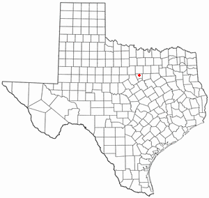
Oak Trail Shores is an unincorporated community and census-designated place (CDP) in Hood County, Texas, United States. Its population was 2,755 at the 2010 census. It is part of the Granbury micropolitan area as well as the Dallas–Fort Worth metroplex.

<span class="mw-page-title-main">Mount Vernon, Virginia</span> Census-designated place in Virginia, United States

Mount Vernon is a census-designated place (CDP) and unincorporated community in Fairfax County, Virginia, United States. The population was 12,416 at the 2010 census. Primarily due to its historical significance and natural recreation and beauty, the Mount Vernon area receives over one million tourists each year.

<span class="mw-page-title-main">Lake Monticello, Virginia</span> Census-designated place in Virginia, United States

Lake Monticello, a private gated community, is a census-designated place (CDP) in Fluvanna County, Virginia, United States. The population was 10,126 at the 2020 census. The community is centered on a lake of the same name, which is formed by a dam on a short tributary of the nearby Rivanna River. Lake Monticello is part of the Charlottesville Metropolitan Statistical Area. Lake Monticello was developed in the 1960s as a summer vacation home community but quickly evolved into a bedroom community of Charlottesville, and to a smaller extent of Richmond. It also has a sizable retirement age population.

North Shore is a census-designated place (CDP) in Franklin County, Virginia, United States. The community lies along State Route 616. It is part of the Roanoke Metropolitan Statistical Area.

Westlake Corner is a census-designated place in Franklin County, Virginia, United States. The population was 1,553 at the 2020 census up fro 976 at the 2010 census. It is part of the Roanoke Metropolitan Statistical Area.

<span class="mw-page-title-main">Cinco Ranch, Texas</span> Census-designated place in Texas, United States

Cinco Ranch is a census-designated place and master-planned community located in the extraterritorial jurisdiction of the city of Houston within Fort Bend and Harris counties in the U.S. state of Texas. According to the United States Census Bureau, the CDP has a total area of 4.9 square miles (12.8 km2).The population was 16,899 at the 2020 census. It lies approximately 25 miles (40 km) west of the Harris County seat of Houston and 10 miles (16 km) north of the Fort Bend County seat of Richmond. Cinco Ranch is considered to be part of the Greater Katy area and is roughly 10 miles southeast of the city of Katy.

<span class="mw-page-title-main">Helendale, California</span> Unincorporated community in California, United States

Helendale or Silver Lakes is an unincorporated community and census-designated place located in the Victor Valley of the Mojave Desert, within San Bernardino County, California.

References

  1. U.S. Census Archived 2012-07-02 at the Wayback Machine
  2. 1 2 U.S. Geological Survey Geographic Names Information System: Lake Sherwood, California
  3. "Census Data: Lake Sherwood (cdp)". United States Census Bureau . Retrieved July 14, 2021.
  4. "Census of Population and Housing". Census.gov. Retrieved June 4, 2016.
  5. "2010 Census Interactive Population Search: CA - Lake Sherwood CDP". U.S. Census Bureau. Archived from the original on July 15, 2014. Retrieved July 12, 2014.
  6. Flemming, Neal J. Leitereg, Jack. "Wayne Gretzky shells out $13.5 million for a familiar place in Thousand Oaks". latimes.com.{{cite web}}: CS1 maint: multiple names: authors list (link)
  7. Behlmer, Rudy (1979). The Adventures of Robin Hood. Madison, Wisconsin: Univ of Wisconsin Press. p. 32. ISBN   0-299-07940-6.
  8. p.21-22 Schneider, Jerry L. Edgar Rice Burroughs and the Silver Screen:Vol. IV: The Locations Lulu.com
  9. p.131 Von Gunden, Kenneth Flights of Fancy: The Great Fantasy Films McFarland
  10. Erdmann, Terry J. (1998). The Secrets of Star Trek:Insurrection. New York City, New York: Pocket Books. p. 58. ISBN   0-671-02494-9.
  11. Schneider, Jerry L. (2014). Lord of the Jungle Filming Locations of California. Lulu Press. Pages 19-21. ISBN   9780983197270.
  12. Schneider, Jerry L. (2015). Western Filming Locations: Book 1. CP Entertainment Books. Pages 126-129. ISBN   9780692561348.
  13. Gunden, Kenneth Von (1989). Flights of Fancy: The Great Fantasy Films. McFarland. Page 131. ISBN   9780786412143.
  14. Times, Los Angeles (March 21, 2016). "On the set of 'What Did You Do in the War, Daddy?'".