Wheeler Springs, California

Last updated

Wheeler Springs, California
Wheeler-springs-smallest-post-office-in-america.png
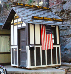
Wheeler Springs was home to America's smallest post office
USA California location map.svg
Red pog.svg
Wheeler Springs, California
Usa edcp location map.svg
Red pog.svg
Wheeler Springs, California
Coordinates: 34°30′29″N119°17′29″W / 34.50806°N 119.29139°W / 34.50806; -119.29139
Country United States
State California
County Ventura
Elevation
1,486 ft (453 m)
Population
 (1980)
  Total50
Time zone UTC-8 (Pacific (PST))
  Summer (DST) UTC-7 (PDT)
ZIP Code
93023
Area code 805
GNIS feature ID254391 [1]

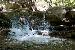
Wheeler Springs is an unincorporated community [2] [3] that grew around a set of sulphurated hot springs in Ventura County, California. [4] It is located 6 miles north of the Ojai Valley, within Los Padres National Forest. It is named for Wheeler Blumberg, who founded the town in 1891, [5] and the many natural hot springs. [6]

Contents

Wheeler Springs is most known for its former resort, natural hot springs and for previously being home to the smallest post office in the U.S. It is also where TV personality Art Linkletter opened the theme park Kiddyland Park. [5] Wheeler Springs is home to numerous campgrounds, including Wheeler Gorge Campground by Matilija Creek, as well as multiple hiking trails and open-space nature areas.

Etymology

Wheeler Springs is named for Wheeler C. Blumberg, who acquired government land surrounding the hot springs. [7] Blumberg discovered the hot springs here in 1890 when he was out on a hunting trip. He shot a deer which fell into a ravine. When Blumberg climbed into the canyon, he discovered hot sulphur springs and cold mountain water springs. [8]

History

Sisxulkuy is on the right side of the map in the Ventureno region Chumash villages.svg
Sisxulkuy is on the right side of the map in the Ventureño region

The first people to inhabit Wheeler Springs was the Chumash. during the Mission period, Wheeler Springs was home to a Chumash village known as Sisxulkuy. [9] It is often assumed that hot springs in Wheeler Springs were sacred to the Chumash people, although there are no archeological evidence to confirm this. [10]

Resort

The Wheeler's Hot Springs resort is located in Wheeler Springs. The founder of the resort, Wheeler Blumberg, established the resort in 1891. It had 14 rental cabins, a swimming pool, bar, and more. In May, 1907, Blumberg locked himself in a room and began shooting through the walls. Blumberg was arrested by a posse and placed in a straitjacket and a padded cell in Ventura. He died the following day at age 43. Webb Wilcox, Blumberg's son-in-law, became the new owner and renamed it Wheeler Hot Springs. [5] California government geologists reported in 1917: [11]

A group of three warm springs flows out of clay banks on both sides of the creek. The larger of the three, consisting of about 11 small springs within a radius of a few feet, has a temperature of 100 °F (38 °C) and flows about 35 US gallons (130 L; 29 imp gal) per minute. This is piped to a swimming tank. The other two springs (Bucket Spring and Genoveva Spring) have temperatures of 62 °F (17 °C) and 75 °F (24 °C) respectively, each flowing about 2 US gallons (7.6 L; 1.7 imp gal) per minute. They are used for drinking purposes. A resort has been conducted here since 1890, open throughout the year, with hotel and cottage accommodations for several hundred people. Electric lights are supplied by a 25-h.p. motor run by a small water-power plant. [11]

The resort operated throughout the 1900s, but closed in 1997. It offered fishing, hunting, swimming, camping, trail riding and dancing and was often visited by Johnny Cash during the 1960s, when Cash resided in nearby Casitas Springs. [10] [3]

There was also a Wheeler Cold Springs, circa 1915, located in Sespe Canyon, that offered seasonal accommodations for hunters and fishermen. [11]

Post office

Wheeler Springs Post Office was established by Webb Wilcox next door to Webb Wilcox Cafe in the mid-1930s. The shack, no larger than a phone booth, was designated by Ripley's Believe it or Not as the smallest post office in America. It was opened after the completion of the Maricopa Highway, which connected the Ojai Valley to the town of Maricopa in Kern County. The community lost its post office status in 1962. The post office was located at 16850 Maricopa Highway. It burned down in December 2017 during the Thomas Fire. [5]

Geography

Matilija Falls in nearby Ojala. Matilija Falls CA.jpg
Matilija Falls in nearby Ojala.

Wheeler Springs is located 5.5 miles north of the Ojai Valley and is situated within Los Padres National Forest. It is located next to Maricopa Highway. Tall mountain peaks, including Nordhoff Ridge, border the village in all directions. It is a mountain community which sits along the North Fork of Matilija Creek. During rainy winters, a waterfall near the highway splashes down into the creek. Creekbeds which cross the highway may contain deep water, making crossing difficult. [12]

The community is situated north of the Topatopa Mountains, east of the Santa Ynez Mountains, and south of the San Rafael Mountains. [13] There are natural mineral water springs, both hot and cold. The hot springs have a temperature of 102 °F (39 °C).

Wheeler Springs is in a rugged, mountainous landscape surrounded by giant oak trees. It is located 100 miles from Los Angeles, [14] 19 miles north of Ventura and 7 miles north of Ojai. California State Route 33 (Maricopa Highway) passes through the village. [15]

Geology

Wheeler Springs is located in a narrow, deeply incised canyon known as Wheeler Gorge, which is eroded by the North Fork of Matilija Creek and cuts through the Santa Ynez-Topatopa Range in northern Ventura County. The canyon is so narrow that three tunnels and an additional three bridges had to be constructed for Maricopa Highway to be built. The North Fork of Matilija Creek joins the main river (Matilija Creek) just south of Wheeler Springs in nearby Ojala, California. From Ojala it drains southward via the Ventura River to the coast. [13]

Recreation

Wheeler Springs is home to Wheeler Gorge Campground and a variety of hiking trails in the Los Padres National Forest.

Hiking Trails

Related Research Articles

<span class="mw-page-title-main">Ventura County, California</span> County in California, United States

Ventura County is a county located in the southern part of the U.S. state of California. As of the 2020 census, the population was 843,843. The largest city is Oxnard, and the county seat is the city of Ventura.

<span class="mw-page-title-main">Ojai, California</span> City in California, United States

Ojai is a city in Ventura County, California. Located in the Ojai Valley, it is northwest of Los Angeles and east of Santa Barbara. The valley is part of the east–west trending Western Transverse Ranges and is about 10 miles (16 km) long by 3 miles (5 km) wide and divided into a lower and an upper valley, each of similar size, surrounded by hills and mountains. The population was 7,637 at the 2020 census, up from 7,461 at the 2010 census.

<span class="mw-page-title-main">Santa Ynez Mountains</span> Mountain range of the Transverse Ranges in California, United States

The Santa Ynez Mountains are a portion of the Transverse Ranges, part of the Pacific Coast Ranges of the west coast of North America. It is the westernmost range in the Transverse Ranges.

<span class="mw-page-title-main">Simi Hills</span> Mountain range of the Transverse Ranges in California, United States

The Simi Hills are a low rocky mountain range of the Transverse Ranges in eastern Ventura County and western Los Angeles County, of southern California, United States.

<span class="mw-page-title-main">California State Route 33</span> Highway in California

State Route 33 is a north–south state highway in the U.S. state of California. It runs north from U.S. Route 101 in Ventura through the Transverse Ranges and the western side of the San Joaquin Valley to Interstate 5 at a point east of Tracy. SR 33 replaced part of U.S. Route 399 in 1964 during the "great renumbering" of routes. In the unincorporated sections of Kern County it is known as the West Side Highway. In addition, the California Legislature designated the entire Kern County portion as the Petroleum Highway in 2004. The southernmost portion in Ventura is a freeway known as the Ojai Freeway, while it is known as the Maricopa Highway from Ojai to Maricopa.

<span class="mw-page-title-main">Sespe Creek</span> Stream in California

Sespe Creek is a stream, some 61 miles (98 km) long, in Ventura County, southern California, in the Western United States. The creek starts at Potrero Seco in the eastern Sierra Madre Mountains, and is formed by more than thirty tributary streams of the Sierra Madre and Topatopa Mountains, before it empties into the Santa Clara River in Fillmore.

<span class="mw-page-title-main">Ventura River</span> River in western Ventura County in southern California, United States

The Ventura River, in western Ventura County in southern California, United States, flows 16.2 miles (26.1 km) from its headwaters to the Pacific Ocean. The smallest of the three major rivers in Ventura County, it flows through the steeply sloped, narrow Ventura Valley, with its final 0.7 miles (1.1 km) through the broader Ventura River estuary, which extends from where it crosses under a 101 Freeway bridge through to the Pacific Ocean.

<span class="mw-page-title-main">Piru Creek</span> Creek in Ventura County, California

Piru Creek is a major stream, about 71 miles (114 km) long, in northern Los Angeles County and eastern Ventura County, California. It is a tributary of the Santa Clara River, the largest stream system in Southern California that is still relatively natural.

<span class="mw-page-title-main">Dick Smith Wilderness</span> Protected wilderness area in California, United States

The Dick Smith Wilderness is a wilderness area in the mountains of eastern Santa Barbara County, California, United States, with a portion in Ventura County. It is completely contained within the Los Padres National Forest, and is northeast of the city of Santa Barbara and north of the city of Ojai. It is most easily accessible from two trailheads off State Route 33, which runs north from Ojai. It is adjacent to the large San Rafael Wilderness on the west and the Matilija Wilderness on the south. Across Highway 33 to the east, and also in the Los Padres National Forest, is the large Sespe Wilderness.

Ventucopa is an unincorporated community in the southeastern Cuyama Valley, within eastern Santa Barbara County, California. Ventucopa has a population of 92 people and is located an elevation of 2,896 feet (883 m). It is an agricultural area situated near the Cuyama River. It is located near the intersection of four counties: Santa Barbara, Ventura, San Luis Obispo and Kern. Ventucopa borders Los Padres National Forest to the east, south and west. When the town was registering a postal office in 1926, local resident Dean Parady came up with Ventucopa, as the community lies between Maricopa and Ventura County.

<span class="mw-page-title-main">Ventura County Council</span>

Ventura County Council of the Boy Scouts of America was officially chartered as Council 57 on June 23, 1921, after a series of meetings that followed a proposal put forward at a County Chamber of Commerce meeting on March 28, 1921, in the Masonic Hall. Mr. C. H. Whipple, then of Moorpark and later Oxnard, became the president; and Col. J.L. Howland became commissioner. Harvey R. Cheesman, an assistant scout executive in the Los Angeles Council, became the first Scout Executive, assuming his duties on July 11.

<span class="mw-page-title-main">Matilija Creek</span> River in California, United States of America

Matilija Creek is a major stream in Ventura County in the U.S. state of California. It joins with North Fork Matilija Creek to form the Ventura River. Many tributaries feed the mostly free flowing, 17.3-mile (27.8 km) creek, which is largely contained in the Matilija Wilderness. Matilija was one of the Chumash rancherias under the jurisdiction of Mission San Buenaventura. The meaning of the Chumash name is unknown.

<span class="mw-page-title-main">Cozy Dell Shale</span> Eocene geologic formation in California

The Cozy Dell Shale is a geologic formation of middle Eocene age that crops out in the Santa Ynez Mountains and Topatopa Mountains of California, extending from north of Fillmore in Ventura County westward to near Point Arguello, north of Santa Barbara. Because the Cozy Dell easily weathers to a clay-rich soil, it crops out infrequently and generally forms dense stands of chaparral in saddles between peaks and ridges of the more resistant Matilija and Coldwater formations.

<span class="mw-page-title-main">Sespe Wilderness</span> Protected wilderness area in California, United States

The Sespe Wilderness is a 219,700-acre (88,900 ha) wilderness area in the eastern Topatopa Mountains and southern Sierra Pelona Mountains, within the Los Padres National Forest (LPNF), in Ventura County, Southern California. The wilderness area is primarily located within the Ojai and Mt. Pinos ranger districts of the LPNF.

<span class="mw-page-title-main">Matilija Dam</span> Arch dam in Ventura County, California

Matilija Dam is a concrete arch dam in Ventura County, California, completed in 1947. Designed for water storage and flood control, it impounds Matilija Creek to create the Matilija Reservoir in the Los Padres National Forest, south of the Matilija Wilderness and north of Ojai.

<span class="mw-page-title-main">Los Padres Condor Range and River Protection Act of 1992</span> US federal law

The Los Padres Condor Range and River Protection Act of 1992 is a Federal law that established five new designated Wilderness Areas and three new designated Wild and Scenic Rivers in the Los Padres National Forest and Angeles National Forest in California. The law was sponsored by California Republican and Ventura County native Robert J. Lagomarsino while he represented California's 19th District in the United States House of Representatives. The legislation was cosponsored by Democratic and Republican representatives from districts representing the entirety of the Los Padres National Forest.

The Matilija Wilderness is a 29,207-acre (11,820 ha) wilderness area in Ventura and Santa Barbara Counties, Southern California. It is managed by the U.S. Forest Service, being situated within the Ojai Ranger District of the Los Padres National Forest. It is located adjacent to the Dick Smith Wilderness to the northwest and the Sespe Wilderness to the northeast, although it is much smaller than either one. The Matilija Wilderness was established in 1992 in part to protect California condor habitat.

The Matilija Fire was a major wildfire that burned nearly 220,000 acres (89,000 ha) in the Santa Barbara National Forest of Southern California, during the autumn of 1932. The fire is named for Matilija Creek, near the location from which it originated.

<span class="mw-page-title-main">Matilija Hot Springs</span> Thermal springs and former resort

Matilija Hot Springs is a thermal spring system of 22 hot and cold springs, and is a former resort located northwest of the town of Ojai, California. The site was designated a Ventura County Historical Landmark (#25) in 1972.

<span class="mw-page-title-main">Lyons Springs</span> Ventura County, California, U.S.

Lyons Springs, sometimes Lyon Spring, originally Nogales Hot Springs, was a naturally occurring sulphur spring and associated resort in Matilija Creek Canyon, near Ojai, Ventura County, California. Located between Vickers Springs and Matilija Hot Springs, the Lyon Spring resort was established in the 1880s.

References

  1. "Wheeler Springs". Geographic Names Information System . United States Geological Survey, United States Department of the Interior.
  2. "Unincorporated Areas" (PDF). Admin.cdn.sos.ca.gov. Retrieved September 23, 2017.
  3. 1 2 SEARLES, JACK (August 11, 1992). "Sweating Out Change : Ojai: Plans to transform the Wheeler Hot Springs spa complex into a destination resort hinge on a stock offering and zoning approvals". Articles.latimes.com. Retrieved September 23, 2017.
  4. Waring 1915, p. 6465.
  5. 1 2 3 4 "The Smallest Post Office in the United States Used to Be in Wheeler Springs, Near Ojai". Conejovalleyguide.com. Retrieved September 23, 2017.
  6. Hill, Mason L. (1987). Cordilleran Section of the Geological Society of America: Decade of North American Geology, Centennial Field Guide Volume 1. Geological Society of America. Page 227. ISBN   9780813754017.
  7. Sheridan, Edwin M. (1917). History of Santa Barbara, San Luis Obispo and Ventura Counties, California, Volume 2. Lewis Publishing Company. Page 847.
  8. Leadabrand, Russ (1967). Exploring California byways: trips for a day or a weekend, Volume 5. W. Ritchie Press. Page 94.
  9. "City of Ojai 2006-2014 Housing Element Update EIR" (PDF). Ojaicity.org. Retrieved September 23, 2017.
  10. 1 2 "Wheeler Hot Springs: New Owners Confront Old Issues". Ojaihistory.com. May 3, 2012. Retrieved September 23, 2017.
  11. 1 2 3 Bradley, Walter W. (1917). "Mineral Springs of Ventura County". Mines and Mineral Resources of the Counties of Monterey, San Benito, San Luis Obispo, Santa Barbara, Ventura. State Mineralogist's Reports. Field Assistants: Emile Huguenin, C. A. Logan, Clarence A. Waring. Ferry Building, San Francisco: California State Mining Bureau. pp. 170–173 via HathiTrust.
  12. Palmer, Norma E. (1994). Santa Barbara & Ventura Counties. Automobile Club of Southern California. Page 189. ISBN   9781564131867.
  13. 1 2 Hill, Mason L. (1987). Cordilleran Section of the Geological Society of America: Decade of North American Geology, Centennial Field Guide Volume 1. Geological Society of America. Page 53. ISBN   9780813754017.
  14. Buck, Albert Henry (1917). A Reference Handbook of the Medical Sciences: Embracing the Entire Range of Scientific and Practical Medicine and Allied Science, Volume 8. W. Wood. Page 500.
  15. Beus, Stanley S. (1986). Southeastern Section of the Geological Society of America. Geological Society of America. Page 227. ISBN   9780813754062.
  16. Carey, Craig R. (2012). Hiking and Backpacking Santa Barbara & Ventura. Wilderness Press. Page 236. ISBN   9780899976358.
  17. Carey, Craig R. (2012). Hiking and Backpacking Santa Barbara & Ventura. Wilderness Press. Page 215. ISBN   9780899976358.

Reference bibliography

  • Waring, Gerald Ashley (1915). Springs of California. U.S. Geological Survey Water Supply Paper. Vol. 338. U.S. Government Printing Office. doi:10.3133/wsp338.