
Yankton County is a county in the U.S. state of South Dakota. As of the 2020 census, the population was 23,310. Its county seat is Yankton. Yankton County comprises the Yankton, SD Micropolitan Statistical Area.

McCook County is a county in the U.S. state of South Dakota. At the 2020 census, the population was 5,682. Its county seat is Salem. The county was established in 1873, and was organized in 1878. It was named for the former governor of the Dakota Territory and Civil War general Edwin Stanton McCook.

Lake County is a county in the U.S. state of South Dakota. As of the 2020 census, the population was 11,059. Its county seat is Madison. The county was formed in 1873.

Hastings is a city mostly in Dakota County, Minnesota, of which it is the county seat, with a portion in Washington County, Minnesota, United States. It is near the confluence of the Mississippi, Vermillion, and St. Croix Rivers. The population was 22,154 at the 2020 census. It is named for the first elected governor of Minnesota, Henry Hastings Sibley.

The North Country National Scenic Trail, generally known as the North Country Trail or simply the NCT, is a footpath stretching over 4,800 miles (7,700 km) from Middlebury in central Vermont to Lake Sakakawea State Park in central North Dakota in the United States; connecting both the Long Trail and the Appalachian Trail with the Lewis and Clark Trail. Passing through the eight states of Vermont, New York, Pennsylvania, Ohio, Michigan, Wisconsin, Minnesota and North Dakota, it is the longest of the eleven National Scenic Trails authorized by Congress. As of early 2019, 3,129 miles (5,036 km) of the trail is in place.
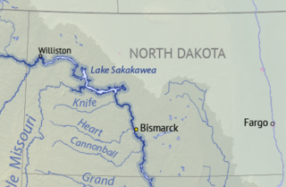
Lake Sakakawea is a large reservoir in the north central United States, impounded in 1953 by Garrison Dam, a U.S. Army Corps of Engineers dam located in the Missouri River basin in central North Dakota. Named for the Shoshone-Hidatsa woman Sakakawea, it is the largest man-made lake located entirely within North Dakota, the second largest in the United States by area after Lake Oahe, and the third largest in the United States by volume, after Lake Mead and Lake Powell.

Lake Sharpe is a large reservoir impounded by Big Bend Dam on the Missouri River in central South Dakota, United States. The lake has an area of 56,884 acres (230.20 km2) and a maximum depth of 78 ft (24 m). Lake Sharpe is approximately 80 mi (130 km) long, with a shoreline of 200 mi (320 km). Lake Sharpe is the 54th largest reservoir in the United States. The lake starts near Ft. Thompson and stretches upstream to Oahe Dam, near Pierre. The lake is located within the following counties: Buffalo, Lyman, Hyde, Hughes, and Stanley. The Big Bend of the Missouri is about 7 miles (11 km) north of the dam.

Lake Oahe is a large reservoir behind Oahe Dam on the Missouri River; it begins in central South Dakota and continues north into North Dakota in the United States. The lake has an area of 370,000 acres (1,500 km2) and a maximum depth of 205 ft (62 m). By volume, it is the fourth-largest reservoir in the US. Lake Oahe has a length of approximately 231 mi (372 km) and has a shoreline of 2,250 mi (3,620 km). 51 recreation areas are located along Lake Oahe, and 1.5 million people visit the reservoir every year. The lake is named for the 1874 Oahe Indian Mission.

Lewis and Clark Lake is a 31,400 acre (130 km²) reservoir located on the border of the U.S. states of Nebraska and South Dakota on the Missouri River. The lake is approximately 25 miles (40 km) in length with over 90 miles (140 km) of shoreline and a maximum water depth of 45 feet (14 m). The lake is impounded by Gavins Point Dam and is managed by the U.S. Army Corps of Engineers, Omaha District.
The Missouri National Recreational River is a National Recreational River located on the border between Nebraska and South Dakota. The designation was first applied in 1978 to a 59-mile section of the Missouri River between Gavins Point Dam and Ponca State Park. In 1991, an additional 39-mile section between Fort Randall Dam and Niobrara, Nebraska, was added to the designation. These two stretches of the Missouri River are the only parts of the river between Montana and the mouth of the Missouri that remain undammed or unchannelized. The last 20 miles of the Niobrara River and 6 miles of Verdigre Creek were also added in 1991.

The Mississippi National River and Recreation Area is a 72-mile (116 km) and 54,000-acre (22,000 ha) protected corridor along the Mississippi River through the Minneapolis–Saint Paul metro in the U.S. state of Minnesota, from the cities of Dayton and Ramsey, to just downstream of Hastings. This stretch of the upper Mississippi River includes natural, historical, recreational, cultural, scenic, scientific, and economic resources of national significance. This area is the only national park site dedicated exclusively to the Mississippi River. The Mississippi National River and Recreation Area is sometimes abbreviated as MNRRA or MISS, the four letter code assigned to the area by the National Park Service. The Mississippi National River and Recreation Area is classified as one of four national rivers in the United States, and despite its name it is technically not one of the 40 national recreation areas.

Split Rock Creek State Park is a state park of Minnesota, USA, located in Ihlen, or just south of Pipestone.

South Dakota Highway 19 (SD 19) is a 86.974-mile (139.971 km) state highway in southeastern South Dakota, United States. It connects the Nebraska state line, south of Vermillion, with the southeastern part of the Madison area, via Viborg, Hurley, Parker, and Humboldt. SD 19 formerly entered Centerville, but was shifted to the south. Its former path was redesignated as SD 19A. Its former southern terminus was at Vermillion, but was extended when a new bridge from Nebraska opened.
Marindahl Lake is a small lake located north of the city of Volin, South Dakota.
Lake Thompson is a lake in Kingsbury County, South Dakota, United States. With an area of 16,236 acres (65.70 km2), it is one of the largest natural lakes in South Dakota. The maximum depth of the lake is 26 ft (7.9 m), and the shoreline has a length of 44.6 miles (71.8 km). The lake is located in east-central South Dakota, on the Coteau des Prairies and is within the watershed of the Vermillion River.

Chief White Crane Recreation Area is a state recreation area in southeastern South Dakota, United States. It is located about 5 miles (8.0 km) west of Yankton and located on the shores of the Missouri River and Lake Yankton. The recreation area is located about 1.5 miles (2.4 km) downstream of Gavins Point Dam and Lewis and Clark Lake.
Pierson Ranch Recreation Area is a state recreation area in Yankton County, South Dakota in the United States. The recreation area is 60 acres (24 ha) and lies directly below Gavins Point Dam and Lewis and Clark Lake and is adjacent to Lake Yankton. The area is open for year-round recreation including camping, swimming, fishing, hiking and boating. It is 4 miles (6.4 km) west of Yankton.
Oahe Downstream Recreation Area is a state recreation area in Stanley County, South Dakota in the United States. The recreation area is named for being immediately downstream of the Oahe Dam and Lake Oahe, a U.S. Army Corps of Engineers dam and reservoir. The recreation area is located along the Missouri River and is popular for camping, fishing and other water-based recreation. The area is located about 7 miles upstream of Pierre - the state capitol. The recreation area was constructed by the U.S. Army Corps of Engineers following construction of Oahe Dam, and legislation passed by Congress transferred ownership of the recreation area to the State of South Dakota in 2002.
Springfield Recreation Area is a state recreation area in Bon Homme County, South Dakota in the United States. The recreation area is located on the upper part of Lewis and Clark Lake, and is popular for boating, fishing, and hunting. There is a 20-site campground and a boat launch to access the lake and the Missouri River. The area is about 30 miles west of Yankton.
Lake Vermillion Recreation Area is a South Dakota state recreation area in McCook County, South Dakota in the United States. The park is open for year-round recreation including camping, swimming, fishing, hiking and boating on Lake Vermillion.


