Lake of Two Mountains

Last updated
Lake of Two Mountains
Ile-aux-Tourtes Bridge.JPG
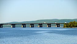
Île aux Tourtes Bridge across Lake of Two Mountains, with Mont Oka in the background
Lake two mountains.png
Location map of Lake of Two Mountains
Canada Quebec relief location map.jpg
Red pog.svg
Lake of Two Mountains
Location Deux-Montagnes RCM / Vaudreuil-Soulanges RCM / Montreal, Quebec
Coordinates 45°27′N74°00′W / 45.450°N 74.000°W / 45.450; -74.000
Native nameLac des Deux Montagnes (French)
Primary inflows Ottawa River
Primary outflows Rivière des Mille Îles, Rivière des Prairies
Basin  countriesCanada

Lake of Two Mountains (French: Lac des Deux Montagnes) is part of the river delta widening of the Ottawa River in Quebec, Canada, at its confluence with the St. Lawrence River.

Lake of Two Mountains has four outflows: Rivière des Mille Îles and Rivière des Prairies, bordering Île Jésus, and two branches of the Ottawa River, flowing into the St. Lawrence via Lake Saint-Louis, on either side of Île Perrot.

The city of Deux-Montagnes is located on the lake's north shore, where it flows into Rivière des Mille Îles. The southwest portion of the city of Montreal borders the eastern part of the lake, as does the village of Senneville. Kanesatake (Kanehsatà:ke), a Kanien'kéha:ka Mohawk reserve in Kanesatake, Quebec, is also located along the northern shore.

Origin of the name

The lake was named lac des Médicis in 1612 by French explorer Samuel de Champlain, then renamed lac des Soissons about 1632. By around 1684 French colonists named it as Lac des Deux Montagnes. The name refers to Calvaire Mountain and Saint-Joseph-du-Lac Hill, the two highest peaks of Mont Oka that face the lake on its northern shore.

See also


Related Research Articles

<span class="mw-page-title-main">Island of Montreal</span> Island in Quebec, Canada

The Island of Montreal is a large island in southwestern Quebec, Canada, that is the site of a number of municipalities, including most of the city of Montreal, and is the most populous island in Canada. It is the main island of the Hochelaga Archipelago at the confluence of the Saint Lawrence and Ottawa rivers.

<span class="mw-page-title-main">Rivière des Mille Îles</span> River in Quebec, Canada

The Rivière des Mille Îles is a channel of the Ottawa River in southwestern Quebec, Canada and runs into the Rivière des Prairies. It is 42 kilometres (26 mi) long.

<span class="mw-page-title-main">Saint-Eustache, Quebec</span> City in Quebec, Canada

Saint-Eustache is an off-island suburb of Montreal, in western Quebec, Canada, west of Montreal on the north shore of the Rivière des Mille Îles. It is located 35 km (22 mi) northwest of Montreal.

<span class="mw-page-title-main">Mirabel, Quebec</span> City in Quebec, Canada

Mirabel is a suburb of Montreal, located on the North Shore in southern Quebec.

<span class="mw-page-title-main">Deux-Montagnes</span> City in Quebec, Canada

Deux-Montagnes is a suburban municipality in Southwestern Quebec, Canada on the north shore of the Rivière des Mille Îles where it flows out of Lake of Two Mountains. It is part of the Deux-Montagnes Regional County Municipality in the greater Montreal region. It is located 40 kilometres (25 mi) from Montreal.

<span class="mw-page-title-main">Kanesatake</span> Mohawk Territory in Quebec, Canada

Kanesatake is a Mohawk settlement on the shore of the Lake of Two Mountains in southwestern Quebec, Canada, at the confluence of the Ottawa and Saint Lawrence rivers and about 48 kilometres (30 mi) west of Montreal. People who reside in Kanehsatà:ke are referred to as Mohawks of Kanesatake. As of 2022, the total registered population was 2,751, with a total of about 1,364 persons living on the territory. Both they and the Mohawk of Kahnawake, Quebec, a reserve located south of the river from Montreal, also control and have hunting and fishing rights to Doncaster 17 Indian Reserve.

<span class="mw-page-title-main">Oka, Quebec</span> Municipality in Quebec, Canada

Oka is a small village on the northern bank of the Ottawa River, northwest of Montreal, Quebec, Canada. Located in the Laurentians valley on Lake of Two Mountains, where the Ottawa has its confluence with the St. Lawrence River, the town is connected via Quebec Route 344. It is located 50 km west of Montreal.

<span class="mw-page-title-main">Argenteuil—Papineau—Mirabel</span> Federal electoral district in Quebec, Canada

<span class="mw-page-title-main">Rivière-des-Mille-Îles (electoral district)</span> Federal electoral district in Quebec, Canada

Rivière-des-Mille-Îles is a federal electoral district in Quebec, Canada, that has been represented in the House of Commons of Canada since 1997.

<span class="mw-page-title-main">Quebec Route 344</span> Highway in Quebec

Route 344 is an east/west highway on the north shore of the Ottawa River in Quebec, Canada. Its western terminus is in Grenville-sur-la-Rouge at the junction of Autoroute 50, and its eastern terminus is in L'Assomption at the junction of Route 343. It follows the Ottawa River from Grenville-sur-la-Rouge to Saint-André-d'Argenteuil, where it follows the Lac des Deux Montagnes until Deux-Montagnes, where it follows the Rivière des Mille Îles until Repentigny, where it follows the Rivière l'Assomption until L'Assomption.

<span class="mw-page-title-main">Sir Wilfrid Laurier School Board</span>

The Sir Wilfrid Laurier School Board is a school board headquartered in Rosemère, Quebec in Greater Montreal.

<span class="mw-page-title-main">North Shore (Montreal)</span> Term for the northern suburbs of Montreal, Canada

The North Shore is the general term for the northern suburbs of Montreal. The North Shore is located in southwestern Quebec on the northern shores of the Rivière des Prairies and the Rivière des Mille Îles, opposite the Island of Montreal and Île Jésus. It consists of twenty municipalities that belong to the Laurentides and Lanaudière administrative regions. While the city of Laval is commonly associated with the North Shore, it is not considered part of the North Shore because of its status as an island.

<span class="mw-page-title-main">Sainte-Marthe-sur-le-Lac</span> City in Quebec, Canada

Sainte-Marthe-sur-le-Lac is an off-island suburb of Montreal, in the Canadian province of Quebec, in the Deux-Montagnes Regional County Municipality, 40 km from Montreal. It is crossed from east to west by Route 344, commonly known as Oka Road. The town shares its borders with Deux-Montagnes to the east, Saint-Joseph-du-Lac to the west, the Lake of Two Mountains to the south, and Saint-Eustache to the north.

<span class="mw-page-title-main">Pointe-Calumet</span> Municipality in Quebec, Canada

Pointe-Calumet is a municipality in the Canadian province of Quebec. The municipality is located within the Deux-Montagnes Regional County Municipality in the Laurentides region. It is situated about 30 minutes northwest of Montreal. Its population as of the 2006 Canadian Census is just over 6 000.

<span class="mw-page-title-main">Saint-Placide, Quebec</span> Municipality in Quebec, Canada

Saint-Placide is a municipality in the Laurentides region of Quebec, Canada, part of the Deux-Montagnes Regional County Municipality, along the north shore of the Ottawa River.

<span class="mw-page-title-main">Rivière à l'Orme</span> River in Quebec, Canada

The Rivière à l'Orme is a tributary of the Lac des Deux Montagnes, flowing into the territory of Pierrefonds, Quebec and Senneville, Quebec, in the city of Montreal, in Quebec, in Canada.

Two Mountains was an electoral district of the Legislative Assembly of the Province of Canada, Canada East, in a rural area north-west of Montreal. It was created in 1841, based on the previous electoral district of the same name for the Legislative Assembly of Lower Canada.

<span class="mw-page-title-main">Lordship of Lac-des-Deux-Montagnes</span> Seigneury in New France

The lordship of Lac-des-Deux-Montagnes was a seigneury in New France. It was located in the current regional county municipality of Deux-Montagnes Regional County Municipality in the administrative region of Laurentides in Quebec (Canada).