Land change science

Last updated
Imaging by NASA of the effects of deforestation on rainfall in Brazil, an example of land change science modeling Deforestationrainfall.jpg
Imaging by NASA of the effects of deforestation on rainfall in Brazil, an example of land change science modeling

Land change science refers to the interdisciplinary study of changes in climate, land use, and land cover. [1] Land change science specifically seeks to evaluate patterns, processes, and consequences in changes in land use and cover over time. The purpose of land change science is to contribute to existing knowledge of climate change and to the development of sustainable resource management and land use policy. The field is informed by a number of related disciplines, such as remote sensing, landscape ecology, and political ecology, and uses a broad range of methods to evaluate the patterns and processes that underlie land cover change. Land change science addresses land use as a coupled human-environment system to understand the impacts of interconnected environmental and social issues, including deforestation and urbanization.

Contents

History

Origin

Human changes to land surfaces have been documented for centuries as having significant impacts on both earth systems and human well-being. The reshaping of landscapes to serve human needs, such as the deforestation for farmland, can have long-term effects on earth systems and exacerbate the causes of climate change. [2] Although the burning of fossil fuels is the primary driver of present-day climate change, prior to the Industrial Revolution, deforestation and irrigation were the largest sources of human-driven greenhouse gas emissions. [2] Even today, 35% of anthropogenic carbon dioxide contributions can be attributed to land use or land cover changes. [2] Currently, almost 50% of Earth’s non-ice land surface has been transformed by human activities, with approximately 40% of that land used for agriculture, surpassing natural systems as the principal source of nitrogen emissions. [2]

Land cover and land use changes, such as land conversion to cropland (yellow regions on map), have significant global-scale impacts. NOAA STAR IGBP LandType.png
Land cover and land use changes, such as land conversion to cropland (yellow regions on map), have significant global-scale impacts.

Land change science is a recently developed field, which emerged in conjunction with the advancement of climate change and global environmental change research, and is important to the evolution of climate change science and adaptation. It is both problem-oriented and interdisciplinary. [3] In the mid-20th century, human-environment relationships were emerging in areas of study such as anthropology and geography. [4] Some scholars assert that the discipline of land change science is loosely derived from German concepts of landscape as the total amount of things within a given territory. [4] In the latter half of the 20th century, scientists studying cultural ecology and risk-assessment ecology worked to develop land change science as a means of addressing land as a human-environment system that can be understood as a foundation of global environmental science. [4]

Thus far, the purpose of land change science has been to: [2]

  1. Observe and monitor land changes underway throughout the world
  2. Understand land change as a human-environmental system
  3. Model land change
  4. Assess system outcomes such as vulnerability, sustainability, and resilience

Influences

Land change science is an interdisciplinary field, and thus is influenced by a number of related areas of study, including remote sensing, political ecology, resource economics, landscape ecology, and biogeography. [2] It is meant to supplement the study of climate change, and through the examination of land cover and land use changes in conjunction with climatic changes over the same period of time, scientists can better understand how human land use practices contribute to a changing climate. [4] Given its close association with the study of climate change, land change science is inherently sustainability research and the scientific knowledge it produces is used to influence the development of sustainable agriculture, and sustainable land use practices and policies. [3]

Dimensions

Land change science mainly operates within the international scientific research frameworks from which its fundamental questions were developed. [4] Although the field has ties to social and cultural studies in its understanding of land and land change as a human-environment system, land change science also focuses on ecosystems and earth systems' structure, function, and effects on land change, independent of human activity. Land change science encompasses a broad scope of dimensions, ranging from quantifying the ecological effects of land cover change, to understanding the socio-environmental drivers for land-use decisions at an institutional level. [5] As a result, land change science relies heavily on the synthesis of a wide range of data and a diverse range of data collection methods, some of which are detailed below. [5]

Land cover monitoring and assessments

A primary function of land change science is to document and model long-term patterns of landscape change, which may result from both human activity and natural processes. [6] In the course of monitoring and assessing land cover and land use changes, scientists look at several factors, including where land-cover and land-use are changing, the extent and timescale of changes, and how changes vary through time. [7] To this end, scientists use a variety of tools, including satellite imagery and other sources of remotely sensed data (e.g., aircraft imagery), field observations, historical accounts, and reconstruction modeling. [6] These tools, particularly satellite imagery, allow land change scientists to accurately monitor land-change rates and create a consistent, long-term record to quantify change variability over time. [7] Through observing patterns in land cover changes, scientists can determine the consequences of these changes, predict the impact of future changes, and use this information to inform strategic land management.

Aral Sea

Remote sensing images show changes to the extent of the Aral Sea from 1989 (left) to 2014 (right). AralSea1989 2014.jpg
Remote sensing images show changes to the extent of the Aral Sea from 1989 (left) to 2014 (right).

The rapid decline of the Aral Sea is an example how local-scale land use and land change can have compounded impacts on regional climate systems, particularly when human activities heavily disrupt natural climatic cycles, how land change science can be used to map and study such changes. [2] In 1960, the Aral Sea, located in Central Asia, was the world's fourth largest lake. [8] However, a water diversion project, undertaken by the Soviet Union to irrigate arid plains in what is now Kazakhstan, Uzbekistan, and Turkmenistan, resulted in the Aral Sea losing 85% of its land cover and 90% of its volume. [8] The loss of the Aral Sea has had a significant effect on human-environment interactions in the region, including the decimation of the sea's fishing industry and the salinization of agricultural lands by the wind-spread of dried sea salt beds. [2] [8] Additionally, scientists have been able to use technology such as NASA's Moderate Resolution Imaging Spectroradiometer (MODIS) to track changes to the Aral Sea and its surrounding climate over time. [9] This use of modeling and satellite imagery to track human-caused land cover change is characteristic of the scope of land change science.

Risk and vulnerability

Modeling risk and vulnerability is also one of land change science's practical applications. Accurate predictions of how human activity will influence land cover change over time, as well as the impact that such changes have on the sustainability of ecological and human systems, can inform the creation of policy designed to address these changes. [10]

Studying risk and vulnerability in the context of land change science entails the development of quantitative, qualitative, and geospatial models, methods, and support tools. [11] The purpose of these tools is to communicate the vulnerability of both human communities and natural ecosystems to hazard events or long-term land change. Modeling risk and vulnerability requires analyses of community sensitivity to hazards, an understanding of geographic distributions of people and infrastructure, and accurate calculation of the probability of specific disturbances occurring. [11]

Land change modeling

A key method for studying risk and vulnerability in the context of land change science is land change modeling (LCM), which can be used to simulate changes and land use and land cover. [12] LCMs can be used to predict how land use and land cover may change under alternate circumstances, which is useful for risk assessment, in that it allows for the prediction of potential impacts and can be used to inform policy decisions, albeit with some uncertainty. [12]

Human impact and land change science

Although land change science involves quantifying the location, extent, and variability of land change cover and the analysis of emergent patterns, it remains fundamentally interdisciplinary, including social and economic components. [7] Human activity is not only the most significant cause of land cover change, but humans are also directly impacted by the environmental consequences of these changes. [7] Collective land use and land cover changes have fundamentally altered the functioning of key Earth systems. [13] For instance, human changes to land use and land cover have a profound impact climate at a local and regional level, which in turn contributes to global warming. [13] More generally, maximizing natural resources and ecosystem services for short-term benefits often hinders the long-term resilience of ecosystems and in turn, their ability to support human needs. [13]

Given the important role that humans play in land cover change, and to understand land change patterns and their affect the climate, land change scientists must identify the social and economic drivers of historic land change. Below are some examples of land use and land cover change that play a key role in the social and economic dimensions of land change science.

Tropical deforestation

Rainforest deforestation for land use conversion Deforestation of Rainforest.jpg
Rainforest deforestation for land use conversion

Deforestation, in the context of land change science, is the systematic and permanent conversion of previously forested land for other uses. [14] It has historically been a primary facilitator of land use and land cover change, is a particular focus of land change science. [10] Forests are a vital part of the global ecosystem and are essential to carbon capture, ecological processes, and biodiversity. [10] However, since the invention of agriculture, global forest cover has diminished by 35%. [10] Further, tropical forests in particular support at least two-thirds of the world's biodiversity, and sustained changes in land cover in these regions are believed to be contributing to a mass extinction. [15] Given the severe ecological consequences resulting from human-driven forest land use conversion, as well as the continuing downward trend in forest cover, to effectively model and evaluate patterns of land use change, scientists must also study the social and economic drivers of deforestation itself.

Land use and land cover change resulting from deforestation is primarily the effect of large-scale socio-economic processes. Importantly, there is rarely one direct or underlying cause for deforestation. [16] Rather, deforestation is the result of intertwining systemic forces working simultaneously or sequentially to change land cover. [16] For instance, mass deforestation is often viewed as the product of industrial agriculture, yet a considerable portion old-growth forest deforestation is the result of small-scale migrant farming. [17] As forest cover is removed, forest resources become exhausted and increasing populations lead to scarcity, which prompts people to move again to previously undisturbed forest, restarting the process of deforestation. [17] This process is referred to as rural-to-rural migration. [17] There are several reasons behind this continued migration: poverty-driven lack of available farmland and high costs may lead to an increase in farming intensity on existing farmland. [17] This leads to the overexploitation of farmland, and down the line results in desertification, another land cover change, which renders soil unusable and unprofitable, requiring farmers to seek out untouched and unpopulated old-growth forests. [17]

In addition to rural migration and subsistence farming, economic development can also play a substantial role in deforestation. [16] For example, road and railway expansions designed to increase quality of life have resulted in significant deforestation in the Amazon and Central America. [16] Moreover, the underlying drivers of economic development are often linked to global economic engagement, instead of to poverty, ranging from increased exports to a foreign debt. [16] Deforestation occurs for many interconnected reasons, and thus it is important for land change scientists to track it in order to identify patterns that can shed light on why and when it happens. Phenomena such as economic insecurity and rural migration are not necessarily quantitative, but they nevertheless provide valuable information to land change science models that attempt to predict future land cover change and its consequences.

Urbanization

An aerial image of New Delhi, India, one of the world's largest urban areas Delhi aerial photo 03-2016 img2.jpg
An aerial image of New Delhi, India, one of the world's largest urban areas

Broadly, urbanization is the increasing number of people who live in urban areas. In the context of land change science, urbanization refers to both urban population growth and the physical growth of urban areas. [18] According to the United Nations, the global urban population has increased rapidly since 1950, from 751 million to 4.2 billion in 2018, and current trends predict this number will continue to grow. [19] Accompanying this population shift are significant changes in economic flow, culture and lifestyle, and spatial population distribution. [19] Although urbanized areas cover just 3% of the Earth's surface, they nevertheless have a significant impact on land use and land cover change. [20]

Urbanization is important to land use and land cover change, and therefore land change science, for a variety of reasons. In particular, urbanization affects land change elsewhere through the shifting of urban-rural linkages, or the ecological footprint of the transfer of goods and services between urban and rural areas. [13] Increases in urbanization lead to increases in consumption, which puts increased pressure on surrounding rural lands. [13] The outward spread of urban areas can also take over adjacent land formerly used for crop cultivation. [13]

Urban heat islands

Urbanization additionally affects land cover through the urban heat island effect. Heat islands occur when, due to high concentrations of structures, such as buildings and roads, that absorb and re-emit solar radiation, and low concentrations of vegetative cover, urban areas experience higher temperatures than surrounding areas. [21] Heat islands can cause increased energy consumption, which results in higher rates of emission for greenhouse gases. [21] The high temperatures associated with heat islands can also compromise human health, particularly in low-income areas. [21] The effects of urban areas on climate indicate that urbanization may become a significant component of land change science.

Obstacles

Land change science as a discipline faces several challenges, many of the stemming from its interdisciplinary qualities or issues with developing inferences using aggregate data. [22] For example, land change science is limited by constraints on data and lack of understanding of underlying issues of land change. [23] Specifically, the spatial models frequently used to study land change may restricted by lack of access to public data on land change, faulty sensors, and high levels of variable uncertainty. [23] Thus, models are often only able to make short-term projections, which severely limits the level of prediction they can provide. [23] Additionally, it is difficult to synthesize and combine the case studies of social-environmental systems that are essential to the study of land change on a global scale. [24] Thus, these setbacks pose fundamental challenges to the connection of communities and environment that land change science seeks to achieve. [22]

See also

Related Research Articles

<span class="mw-page-title-main">Deforestation</span> Conversion of forest to non-forest for human use

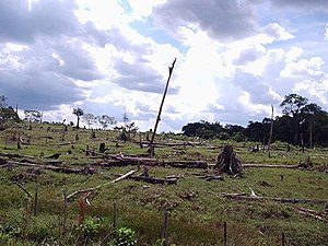
Deforestation or forest clearance is the removal and destruction of a forest or stand of trees from land that is then converted to non-forest use. Deforestation can involve conversion of forest land to farms, ranches, or urban use. About 31% of Earth's land surface is covered by forests at present. This is one-third less than the forest cover before the expansion of agriculture, with half of that loss occurring in the last century. Between 15 million to 18 million hectares of forest, an area the size of Bangladesh, are destroyed every year. On average 2,400 trees are cut down each minute. Estimates vary widely as to the extent of deforestation in the tropics. In 2019, nearly a third of the overall tree cover loss, or 3.8 million hectares, occurred within humid tropical primary forests. These are areas of mature rainforest that are especially important for biodiversity and carbon storage.

<span class="mw-page-title-main">Land use</span> Classification of land resources based on what can be built and on its use

Land use involves the management and modification of natural environment or wilderness into built environment such as settlements and semi-natural habitats such as arable fields, pastures, and managed woods. Land use by humans has a long history, first emerging more than 10,000 years ago. It has been defined as "the purposes and activities through which people interact with land and terrestrial ecosystems" and as "the total of arrangements, activities, and inputs that people undertake in a certain land type." Land use is one of the most important drivers of global environmental change.

<span class="mw-page-title-main">Landscape ecology</span> Science of relationships between ecological processes in the environment and particular ecosystems

Landscape ecology is the science of studying and improving relationships between ecological processes in the environment and particular ecosystems. This is done within a variety of landscape scales, development spatial patterns, and organizational levels of research and policy. Concisely, landscape ecology can be described as the science of "landscape diversity" as the synergetic result of biodiversity and geodiversity.

<span class="mw-page-title-main">Urban ecology</span> Scientific study of living organisms

Urban ecology is the scientific study of the relation of living organisms with each other and their surroundings in an urban environment. An urban environment refers to environments dominated by high-density residential and commercial buildings, paved surfaces, and other urban-related factors that create a unique landscape. The goal of urban ecology is to achieve a balance between human culture and the natural environment.

<span class="mw-page-title-main">Exploitation of natural resources</span> Use of natural resources for economic growth

The exploitation of natural resources describes using natural resources, often non-renewable or limited, for economic growth or development. Environmental degradation, human insecurity, and social conflict frequently accompany natural resource exploitation. The impacts of the depletion of natural resources include the decline of economic growth in local areas; however, the abundance of natural resources does not always correlate with a country's material prosperity. Many resource-rich countries, especially in the Global South, face distributional conflicts, where local bureaucracies mismanage or disagree on how resources should be utilized. Foreign industries also contribute to resource exploitation, where raw materials are outsourced from developing countries, with the local communities receiving little profit from the exchange.

<span class="mw-page-title-main">Environmental degradation</span> Any change or disturbance to the environment perceived to be deleterious or undesirable

Environmental degradation is the deterioration of the environment through depletion of resources such as quality of air, water and soil; the destruction of ecosystems; habitat destruction; the extinction of wildlife; and pollution. It is defined as any change or disturbance to the environment perceived to be deleterious or undesirable. The environmental degradation process amplifies the impact of environmental issues which leave lasting impacts on the environment.

<span class="mw-page-title-main">Forestation</span>

Forestation is a vital ecological process where forests are established and grown through afforestation and reforestation efforts. Afforestation involves planting trees on previously non-forested lands, while reforestation focuses on replanting trees in areas that were once deforested. This process plays an important role in restoring degraded forests, enhancing ecosystems, promoting carbon sequestration, and biodiversity conservation.

<span class="mw-page-title-main">Land development</span> Landscape alteration

Land development is the alteration of landscape in any number of ways such as:

<span class="mw-page-title-main">Habitat destruction</span> Process by which a natural habitat becomes incapable of supporting its native species

Habitat destruction occurs when a natural habitat is no longer able to support its native species. The organisms once living there have either moved to elsewhere or are dead, leading to a decrease in biodiversity and species numbers. Habitat destruction is in fact the leading cause of biodiversity loss and species extinction worldwide.

<span class="mw-page-title-main">Urban ecosystem</span> Structure of civilization

In ecology, urban ecosystems are considered a ecosystem functional group within the intensive land-use biome. They are structurally complex ecosystems with highly heterogeneous and dynamic spatial structure that is created and maintained by humans. They include cities, smaller settlements and industrial areas, that are made up of diverse patch types. Urban ecosystems rely on large subsidies of imported water, nutrients, food and other resources. Compared to other natural and artificial ecosystems human population density is high, and their interaction with the different patch types produces emergent properties and complex feedbacks among ecosystem components.

<span class="mw-page-title-main">Forest transition</span> Geographic theory describing land use

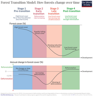
Forest transition refers to a geographic theory describing a reversal or turnaround in land-use trends for a given territory from a period of net forest area loss to a period of net forest area gain. The term "landscape turnaround" has also been used to represent a more general recovery of natural areas that is independent of biome type.

<span class="mw-page-title-main">Deforestation in Brazil</span>

Brazil once had the highest deforestation rate in the world and in 2005 still had the largest area of forest removed annually. Since 1970, over 700,000 square kilometres (270,000 sq mi) of the Amazon rainforest have been destroyed. In 2001, the Amazon was approximately 5,400,000 square kilometres (2,100,000 sq mi), which is only 87% of the Amazon's original size. According to official data, about 729,000 km² have already been deforested in the Amazon biome, which corresponds to 17% of the total. 300,000 km² have been deforested in the last 20 years.

<span class="mw-page-title-main">Deforestation in Nigeria</span>

Deforestation in Nigeria refers to the extensive and rapid clearing of forests within the borders of Nigeria. This environmental issue has significant impacts on both local and global scales.

<span class="mw-page-title-main">Computational sustainability</span>

Computational sustainability is an emerging field that attempts to balance societal, economic, and environmental resources for the future well-being of humanity using methods from mathematics, computer science, and information science fields. Sustainability in this context refers to the world's ability to sustain biological, social, and environmental systems in the long term. Using the power of computers to process large quantities of information, decision making algorithms allocate resources based on real-time information. Applications advanced by this field are widespread across various areas. For example, artificial intelligence and machine learning techniques are created to promote long-term biodiversity conservation and species protection. Smart grids implement renewable resources and storage capabilities to control the production and expenditure of energy. Intelligent transportation system technologies can analyze road conditions and relay information to drivers so they can make smarter, more environmentally-beneficial decisions based on real-time traffic information.

Akure Forest Reserve is a protected area in southwest Nigeria, covering 66 km2 (25 sq mi). The Akure Forest Reserve, established in 1948 and spanning approximately 32 hectares. It was created with the primary aim of safeguarding the genetic diversity of the forest ecosystem. About 11.73% is estimated to be cleared for cocoa farming and other food crops. Aponmu and Owena Yoruba speaking communities owned the forest, though, there are also minor settlements surrounding the forest. They include Ipogun, Kajola/ Aponmu, Kajola, Ago Petesi, Akika Camp, Owena Town, Ibutitan/Ilaro Camp, Elemo Igbara Oke Camp and Owena Water new Dam.

At the global scale sustainability and environmental management involves managing the oceans, freshwater systems, land and atmosphere, according to sustainability principles.

<span class="mw-page-title-main">Forest restoration</span>

Forest restoration is defined as “actions to re-instate ecological processes, which accelerate recovery of forest structure, ecological functioning and biodiversity levels towards those typical of climax forest” i.e. the end-stage of natural forest succession. Climax forests are relatively stable ecosystems that have developed the maximum biomass, structural complexity and species diversity that are possible within the limits imposed by climate and soil and without continued disturbance from humans. Climax forest is therefore the target ecosystem, which defines the ultimate aim of forest restoration. Since climate is a major factor that determines climax forest composition, global climate change may result in changing restoration aims. Additionally, the potential impacts of climate change on restoration goals must be taken into account, as changes in temperature and precipitation patterns may alter the composition and distribution of climax forests.

<span class="mw-page-title-main">Deforestation and climate change</span> Relationship between deforestation and global warming

Deforestation is a primary contributor to climate change, and climate change affects the health of forests. Land use change, especially in the form of deforestation, is the second largest source of carbon dioxide emissions from human activities, after the burning of fossil fuels. Greenhouse gases are emitted from deforestation during the burning of forest biomass and decomposition of remaining plant material and soil carbon. Global models and national greenhouse gas inventories give similar results for deforestation emissions. As of 2019, deforestation is responsible for about 11% of global greenhouse gas emissions. Carbon emissions from tropical deforestation are accelerating.

<span class="mw-page-title-main">Climate change and cities</span>

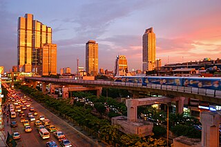
Climate change and cities are deeply connected. Cities are one of the greatest contributors and likely best opportunities for addressing climate change. Cities are also one of the most vulnerable parts of the human society to the effects of climate change, and likely one of the most important solutions for reducing the environmental impact of humans. The UN projects that 68% of the world population will live in urban areas by 2050. In the year 2016, 31 mega-cities reported having at least 10 million in their population, 8 of which surpassed 20 million people. However, secondary cities - small to medium size cities are rapidly increasing in number and are some of the fastest growing urbanizing areas in the world further contributing to climate change impacts. Cities have a significant influence on construction and transportation—two of the key contributors to global warming emissions. Moreover, because of processes that create climate conflict and climate refugees, city areas are expected to grow during the next several decades, stressing infrastructure and concentrating more impoverished peoples in cities.

<span class="mw-page-title-main">Telecoupling</span>

Telecoupling is a strategy that comprehensively analyzes both the socioeconomic and environmental impacts over long distances. The concept of telecoupling is a logical extension of research on coupled human and natural systems, in which interactions occur within particular geographic locations. The telecoupling framework derives from the understanding that all land systems are connected through coupled human and natural systems, and these that social, ecological, and economic impacts are the result. The term telecoupling was first coined by Jianguo Liu as an evolution of the term teleconnection. While teleconnection makes reference to atmospheric sciences only, telecoupling references the integration of multiple scientific disciplines including social science, environmental science, natural science, and systems science. The integration of these dynamic fields of science is what allows the telecoupling framework to comprehensively analyze distal connections that have been previously understudied and unacknowledged.

References

  1. "Land Change Science Program - Science". www.usgs.gov. Archived from the original on 2021-02-10. Retrieved 2021-02-09.
  2. 1 2 3 4 5 6 7 8 Turner, B. L.; Lambin, Eric F.; Reenberg, Anette (2007-12-26). "The emergence of land change science for global environmental change and sustainability". Proceedings of the National Academy of Sciences. 104 (52): 20666–20671. doi: 10.1073/pnas.0704119104 . ISSN   0027-8424. PMC   2409212 . PMID   18093934.
  3. 1 2 Messerli, Peter; Heinimann, Andreas; Giger, Markus; Breu, Thomas; Schönweger, Oliver (2013-10-01). "From 'land grabbing' to sustainable investments in land: potential contributions by land change science". Current Opinion in Environmental Sustainability. 5 (5): 528–534. Bibcode:2013COES....5..528M. doi: 10.1016/j.cosust.2013.03.004 . ISSN   1877-3435.
  4. 1 2 3 4 5 Turner, B.L.; Robbins, Paul (November 2008). "Land-Change Science and Political Ecology: Similarities, Differences, and Implications for Sustainability Science". Annual Review of Environment and Resources. 33 (1): 295–316. doi: 10.1146/annurev.environ.33.022207.104943 . ISSN   1543-5938.
  5. 1 2 Magliocca, Nicholas R.; Rudel, Thomas K.; Verburg, Peter H.; McConnell, William J.; Mertz, Ole; Gerstner, Katharina; Heinimann, Andreas; Ellis, Erle C. (February 2015). "Synthesis in land change science: methodological patterns, challenges, and guidelines". Regional Environmental Change. 15 (2): 211–226. Bibcode:2015REnvC..15..211M. doi: 10.1007/s10113-014-0626-8 . ISSN   1436-3798. PMC   4372122 . PMID   25821402.
  6. 1 2 "Land Cover Monitoring and Assessments | USGS.gov". www.usgs.gov. Archived from the original on 2021-02-10. Retrieved 2021-02-09.
  7. 1 2 3 4 "The Science of LCLUC | LCLUC". lcluc.umd.edu. Archived from the original on 2021-01-17. Retrieved 2021-03-08.
  8. 1 2 3 Middleton, Nick (2019). The Global Casino: An Introduction to Environmental Issues. London & New York: Routledge. pp. 179–182. ISBN   978-1-315-15840-2.
  9. "World of Change: Shrinking Aral Sea". earthobservatory.nasa.gov. 2014-09-24. Archived from the original on 2021-03-20. Retrieved 2021-03-08.
  10. 1 2 3 4 Mayer, Audrey L.; Buma, Brian; Davis, Amélie; Gagné, Sara A.; Loudermilk, E. Louise; Scheller, Robert M.; Schmiegelow, Fiona K.A.; Wiersma, Yolanda F.; Franklin, Janet (2016-04-27). "How Landscape Ecology Informs Global Land-Change Science and Policy". BioScience. 66 (6): 458–469. doi: 10.1093/biosci/biw035 . hdl: 11122/8174 . ISSN   0006-3568.
  11. 1 2 "Risk and Vulnerability | USGS.gov". www.usgs.gov. Archived from the original on 2021-01-25. Retrieved 2021-02-09.
  12. 1 2 Van Vliet, Jasper; Bregt, Arnold K.; Brown, Daniel G.; Van Delden, Hedwig; Heckbert, Scott; Verburg, Peter H. (2016-08-01). "A review of current calibration and validation practices in land-change modeling". Environmental Modelling & Software. 82: 174–182. Bibcode:2016EnvMS..82..174V. doi:10.1016/j.envsoft.2016.04.017. ISSN   1364-8152. Archived from the original on 2021-04-18. Retrieved 2021-04-09.
  13. 1 2 3 4 5 6 Lambin, Eric F.; Turner, B.L.; Geist, Helmut J.; Agbola, Samuel B.; Angelsen, Arild; Bruce, John W.; Coomes, Oliver T.; Dirzo, Rodolfo; Fischer, Günther; Folke, Carl; George, P.S.; Homewood, Katherine; Imbernon, Jacques; Leemans, Rik; Li, Xiubin; Moran, Emilio F.; Mortimore, Michael; Ramakrishnan, P.S.; Richards, John F.; Skånes, Helle; Steffen, Will; Stone, Glenn D.; Svedin, Uno; Veldkamp, Tom A.; Vogel, Coleen; Xu, Jianchu (2001-12-01). "The causes of land-use and land-cover change: moving beyond the myths". Global Environmental Change. 11 (4): 261–269. doi:10.1016/S0959-3780(01)00007-3. ISSN   0959-3780. Archived from the original on 2020-07-05. Retrieved 2021-04-09.
  14. Derouin, Sarah (2019). "Deforestation: Facts, Causes & Effects". livescience.com. Archived from the original on 2020-12-20. Retrieved 2021-03-08.
  15. Giam, Xingli (2017-06-06). "Global biodiversity loss from tropical deforestation". Proceedings of the National Academy of Sciences. 114 (23): 5775–5777. Bibcode:2017PNAS..114.5775G. doi: 10.1073/pnas.1706264114 . ISSN   0027-8424. PMC   5468656 . PMID   28550105.
  16. 1 2 3 4 5 "Tropical Deforestation". earthobservatory.nasa.gov. 2007-03-30. Archived from the original on 2021-03-31. Retrieved 2021-04-08.
  17. 1 2 3 4 5 López-Carr, David; Burgdorfer, Jason (2013-01-01). "Deforestation Drivers: Population, Migration, and Tropical Land Use". Environment: Science and Policy for Sustainable Development. 55 (1): 3–11. Bibcode:2013ESPSD..55a...3L. doi:10.1080/00139157.2013.748385. ISSN   0013-9157. PMC   3857132 . PMID   24347675.
  18. "Urbanization". ScienceDaily. Archived from the original on 2021-01-13. Retrieved 2021-04-09.
  19. 1 2 United Nations, Department of Economic and Social Affairs, Population Division (2019). World Urbanization Prospects 2018: Highlights (ST/ESA/SER.A/421).
  20. Liu, Zhifeng; He, Chunyang; Zhou, Yuyu; Wu, Jianguo (May 2014). "How much of the world's land has been urbanized, really? A hierarchical framework for avoiding confusion". Landscape Ecology. 29 (5): 763–771. Bibcode:2014LaEco..29..763L. doi:10.1007/s10980-014-0034-y. ISSN   0921-2973. S2CID   207209868.
  21. 1 2 3 US EPA, OAR (2014-02-28). "Heat Island Effect". US EPA. Archived from the original on 2021-04-07. Retrieved 2021-04-09.
  22. 1 2 Rindfuss, Ronald R.; Walsh, Stephen J.; Turner, B. L.; Fox, Jefferson; Mishra, Vinod (2004-09-28). "Developing a science of land change: Challenges and methodological issues". Proceedings of the National Academy of Sciences. 101 (39): 13976–13981. Bibcode:2004PNAS..10113976R. doi: 10.1073/pnas.0401545101 . ISSN   0027-8424. PMC   521107 . PMID   15383671.
  23. 1 2 3 Council, National Research (2013-09-16). Advancing Land Change Modeling: Opportunities and Research Requirements. doi:10.17226/18385. ISBN   978-0-309-28833-0. Archived from the original on 2021-04-16. Retrieved 2021-04-16.
  24. "GLOBE: Global Collaboration Engine - Land Change Science". Archived from the original on 2021-04-16. Retrieved 2021-04-16.