Lanesborough, Massachusetts

Last updated

Lanesborough, Massachusetts
Lanesborough Town Hall.JPG
Lanesborough Town Hall
Seal of Lanesborough, Massachusetts.png
Nickname(s): 
New Framingham
(former official name)
Motto(s): 
Liberté Toute Entière(French)
"Liberty Unfettered"
Berkshire County Massachusetts incorporated and unincorporated areas Lanesborough highlighted.svg
Location in Berkshire County and the state of Massachusetts.
Coordinates: 42°31′02″N73°13′43″W / 42.51722°N 73.22861°W / 42.51722; -73.22861
Country Flag of the United States.svg  United States
State Flag of Massachusetts.svg  Massachusetts
County Berkshire
Settled1753
Incorporated1765
Government
  Type Open town meeting
Area
  Total76.6 km2 (29.6 sq mi)
  Land74.7 km2 (28.8 sq mi)
  Water1.9 km2 (0.7 sq mi)
Elevation
344 m (1,130 ft)
Population
 (2020)
  Total3,038
  Density40/km2 (100/sq mi)
Time zone UTC−5 (Eastern)
  Summer (DST) UTC−4 (Eastern)
ZIP Code
01237
Area code 413
FIPS code 25-34340
GNIS feature ID0618267
Website www.lanesborough-ma.gov

Lanesborough is a town in Berkshire County, Massachusetts, United States. It is part of the Pittsfield, Massachusetts Metropolitan Statistical Area. The population was 3,038 at the 2020 census. [1]

Contents

History

One of the first Berkshire communities to be settled, Lanesborough was originally known as "New Framingham", carved from part of Northern Berkshire Township #6. Lanesborough was first settled in 1753 and was officially incorporated on January 21, 1765. It was renamed Lanesborough, for the Countess of Lanesborough, a friend of Governor Francis Bernard, who incorporated the town. The town grew with small industry in the early 19th century, most of which settled along Town Brook. Berkshire Pleasure Park was a major attraction at the turn of the 20th century. It was one of the trolley parks along what is now Route 8 on the eastern side of town.

Today the town includes many small businesses, but has little industry of its own. More people from Lanesborough are employed in nearby communities.

The town's most famous resident was Josh Billings, born Henry Wheeler Shaw. He was a popular humorist in the nineteenth century, rivaling Mark Twain for popularity at the time. Historic sites include the Old Stone School, an unusual stone one-room schoolhouse, built in 1832 from funds donated by Ephraim Bradley and which operated as a school until 1950. The building is currently used as a photography gallery and guesthouse. [2] [3]

Geography

According to the United States Census Bureau, the town has a total area of 29.6 square miles (76.6 km2), of which 28.8 square miles (74.7 km2) is land and 0.73 square miles (1.9 km2), or 2.49%, is water. [4]

Lanesborough is bordered by New Ashford to the north, Cheshire to the northeast, Dalton to the east, Pittsfield to the south, and Hancock to the west. The town center is 5 miles (8 km) north of Pittsfield, 50 miles (80 km) northwest of Springfield and 140 miles (230 km) west of Boston.

Lanesborough is situated in two valleys, with Town Brook running south through the central valley into Pontoosuc Lake, and the Cheshire Reservoir, the headwaters of the Hoosic River, running north through the town's smaller, eastern valley. To the north, the beginning of Mount Greylock is located in the town, with the auto road and visitors' center beginning there as well. Rockwell Road, which leads to the Visitors' Center, ascends from Lanesborough through Cheshire to the summit in Adams. Sperry Road, which branches off Rockwell, leads to a campground and picnic area. Pittsfield State Forest also has a large section within town, with Balance Rock [5] being its main attraction. To the west, Jiminy Peak and Sheeps Heaven Mountain, the southern portion of Brodie Mountain, form much of the western border. While much of Jiminy Peak is located in the town of Hancock, recent aerial mapping determined that the summit is indeed in Lanesborough. The ski area's Hendricks Summit Lodge (named after Lanesborough residents Bart and Mary Hendricks) is located within the town. Brodie Mountain Road, which passes between these two mountains, is one of the few roads which lead into neighboring Hancock from the east. The very large Massachusetts Champion Elm stands on Summer Street, visible from Route 7. Lanesborough hosts the southern access to the Ashuwillticook Rail Trail, a bike path converted from a railway path.

U.S. Route 7 is the main route through town, passing from Pittsfield north towards Williamstown and Vermont. This road was once New England Interstate Route 4, which connected Norwalk, Connecticut, with the Canada–US border. To the east, Massachusetts Route 8, which was also a New England Interstate Route, passes through the village of Berkshire towards North Adams. Route 8 lies along a route of the Berkshire Regional Transit Authority bus line. Regional bus and air service can both be found in Pittsfield, with the nearest airport with national flights being Albany International Airport.

Demographics

Historical population
YearPop.±%
1850 1,229    
1860 1,308+6.4%
1870 1,393+6.5%
1880 1,286−7.7%
1890 1,018−20.8%
1900 780−23.4%
1910 947+21.4%
1920 1,054+11.3%
1930 1,170+11.0%
1940 1,321+12.9%
1950 2,069+56.6%
1960 2,933+41.8%
1970 2,972+1.3%
1980 3,131+5.3%
1990 3,032−3.2%
2000 2,990−1.4%
2010 3,091+3.4%
2020 3,038−1.7%
2022*3,016−0.7%
* = population estimate.
Source: United States census records and Population Estimates Program data. [6] [7] [8] [9] [10] [11] [12] [13] [14] [15] [16]

As of the census [17] of 2000, there were 2,990 people, 1,203 households, and 839 families residing in the town. By population, Lanesborough ranks eleventh out of the 32 cities and towns in Berkshire County, and 273rd out of 351 cities and towns in Massachusetts. The population density was 103.0 inhabitants per square mile (39.8/km2), ranking it 11th and 279th in the county and Commonwealth, respectively. There were 1,382 housing units at an average density of 47.6 per square mile (18.4/km2). The racial makeup of the town was 97.36% White, 0.70% African American, 0.03% Native American, 0.80% Asian, 0.03% Pacific Islander, 0.17% from other races, and 0.90% from two or more races. Hispanic or Latino of any race were 0.67% of the population.

There were 1,203 households, out of which 32.8% had children under the age of 18 living with them, 56.4% were married couples living together, 9.5% had a female householder with no husband present, and 30.2% were non-families. Of all households, 23.9% were made up of individuals, and 9.1% had someone living alone who was 65 years of age or older. The average household size was 2.48 and the average family size was 2.95.

In the town, the population was spread out, with 23.9% under the age of 18, 6.0% from 18 to 24, 29.4% from 25 to 44, 27.7% from 45 to 64, and 13.0% who were 65 years of age or older. The median age was 40 years. For every 100 females, there were 96.7 males. For every 100 females age 18 and over, there were 95.0 males.

The median income for a household in the town was $46,496, and the median income for a family was $51,887. Males had a median income of $37,672 versus $24,583 for females. The per capita income for the town was $21,106. About 3.7% of families and 5.7% of the population were below the poverty line, including 5.0% of those under age 18 and 8.0% of those age 65 or over. [18]

Government

Lanesborough employs the open town meeting form of government, and is led by a board of selectmen. The town operates its own police, fire and public works departments. The town library, located in the annex of the town hall, is connected to the regional library networks.

On the state level, Lanesborough is represented in the Massachusetts House of Representatives as part of the First Berkshire District, which covers north Berkshire County and is represented by John Barrett. In the Massachusetts Senate, the town is part of the Berkshire, Hampshire and Franklin district, which includes all of Berkshire County and western Hampshire and Franklin counties, represented by Adam Hinds. [19] On the national level, Lanesborough is represented in the United States House of Representatives by Richard Neal as part of Massachusetts's 1st congressional district.

Education

Lanesborough, along with Hancock, New Ashford, and Williamstown form the Mount Greylock Regional School District, which includes a middle school and a high school. The town operates Pontoosuc Regional Elementary School for students from pre-kindergarten through sixth grade along with New Ashford, with the upper grades attending Mount Greylock Regional High School in Williamstown. Additionally, there are private, parochial, charter and vocation schools in the nearby towns.

The nearest community college, Berkshire Community College, is in Pittsfield. The nearest state college is Massachusetts College of Liberal Arts in North Adams, and the nearest university is the University of Massachusetts Amherst. Williams College in Williamstown is the nearest private college.

Notable people

Sister city

Related Research Articles

<span class="mw-page-title-main">Berkshire County, Massachusetts</span> County in Massachusetts, United States

Berkshire County is the westernmost county in the U.S. state of Massachusetts. As of the 2020 census, the population was 129,026. Its largest city and traditional county seat is Pittsfield. The county was founded in 1761. The Berkshire Hills are centered on Berkshire County. Residents are known as Berkshirites. It exists today only as a historical geographic region, and has no county government, with the exception of the retirement board for former county workers, and certain offices such as the sheriff and registry of deeds.

<span class="mw-page-title-main">Becket, Massachusetts</span> Town in Massachusetts, United States

Becket is a town in Berkshire County, Massachusetts, United States. It is part of the Pittsfield, Massachusetts Metropolitan Statistical Area. The population was 1,931 at the 2020 census.

<span class="mw-page-title-main">Cheshire, Massachusetts</span> Town in Massachusetts, United States

Cheshire is a town in Berkshire County, Massachusetts, United States. It is part of the Pittsfield, Massachusetts Metropolitan Statistical Area. The population was 3,258 at the 2020 census.

<span class="mw-page-title-main">Clarksburg, Massachusetts</span> Town in Massachusetts, United States

Clarksburg is a town in Berkshire County, Massachusetts, United States. It is part of the Pittsfield, Massachusetts Metropolitan Statistical Area. The population was 1,657 at the 2020 census.

<span class="mw-page-title-main">Dalton, Massachusetts</span> Town in Massachusetts, United States

Dalton is a town in Berkshire County, Massachusetts, United States. Dalton is a transition town between the urban and rural portions of Berkshire County. It is part of the Pittsfield, Massachusetts Metropolitan Statistical Area. The population was 6,330 at the 2020 census.

<span class="mw-page-title-main">Florida, Massachusetts</span> Town in Massachusetts, United States

Florida is a town in Berkshire County, Massachusetts, United States. It is part of the Pittsfield, Massachusetts Metropolitan Statistical Area. It is home to the east portal of the Hoosac Tunnel, as well as Whitcomb Summit, the highest point of the Mohawk Trail. Florida contains the village of Drury. At the 2020 census the town had a total population of 694. Despite the town’s name, Florida is statistically the coldest and snowiest town in Massachusetts.

<span class="mw-page-title-main">Hancock, Massachusetts</span> Town in Massachusetts, United States

Hancock is a town in Berkshire County, Massachusetts, United States. It is part of the Pittsfield, Massachusetts Metropolitan Statistical Area. The population was 757 at the 2020 census.

<span class="mw-page-title-main">New Ashford, Massachusetts</span> Town in Massachusetts, United States

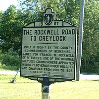
New Ashford is a town in Berkshire County, Massachusetts, United States. It is part of the Pittsfield, Massachusetts Metropolitan Statistical Area. The population was 250 at the 2020 census.

<span class="mw-page-title-main">North Adams, Massachusetts</span> City in Massachusetts, United States

North Adams is a city in Berkshire County, Massachusetts, United States. It is part of the Pittsfield, Massachusetts Metropolitan Statistical Area. Its population was 12,961 as of the 2020 census. Best known as the home of the largest contemporary art museum in the United States, the Massachusetts Museum of Contemporary Art, North Adams has in recent years become a center for tourism, culture and recreation.

<span class="mw-page-title-main">Otis, Massachusetts</span> Town in Massachusetts, United States

Otis is a town in Berkshire County, Massachusetts, United States. It is part of the Pittsfield, Massachusetts, Metropolitan Statistical Area. The population was 1,634 at the 2020 census.

<span class="mw-page-title-main">Peru, Massachusetts</span> Town in Massachusetts, United States

Peru is a town in Berkshire County, Massachusetts, United States. The population was 814 at the 2020 census.

<span class="mw-page-title-main">Pittsfield, Massachusetts</span> City in Massachusetts, United States

Pittsfield is the largest city and the county seat of Berkshire County, Massachusetts, United States. It is the principal city of the Pittsfield, Massachusetts Metropolitan Statistical Area which encompasses all of Berkshire County. Pittsfield’s population was 43,927 at the 2020 census. Although its population has declined in recent decades, Pittsfield remains the third-largest municipality in Western Massachusetts, behind only Springfield and Chicopee.

<span class="mw-page-title-main">Richmond, Massachusetts</span> Town in Massachusetts, United States

Richmond is a town in Berkshire County, Massachusetts, United States. It is part of the Pittsfield, Massachusetts Metropolitan Statistical Area. The population was 1,407 at the 2020 census.

<span class="mw-page-title-main">Sandisfield, Massachusetts</span> Town in Massachusetts, United States

Sandisfield is a town in Berkshire County, Massachusetts, United States. It is part of the Pittsfield, Massachusetts Metropolitan Statistical Area. The population was 989 at the 2020 census.

<span class="mw-page-title-main">Savoy, Massachusetts</span> Town in Massachusetts, United States

Savoy is a town in Berkshire County, Massachusetts, United States. It is part of the Pittsfield, Massachusetts Metropolitan Statistical Area. The population was 645 at the 2020 census.

<span class="mw-page-title-main">Washington, Massachusetts</span> Town in Massachusetts, United States

Washington is a town in Berkshire County, Massachusetts, United States. It is part of the Pittsfield, Massachusetts, Metropolitan Statistical Area. The population was 494 at the 2020 census.

<span class="mw-page-title-main">Windsor, Massachusetts</span> Town in Massachusetts, United States

Windsor is a town in Berkshire County, Massachusetts, United States. It is part of the Metropolitan Statistical Area of Pittsfield, Massachusetts. The population was 831 at the 2020 census.

<span class="mw-page-title-main">Hawley, Massachusetts</span> Town in Massachusetts, United States

Hawley is a town in Franklin County, Massachusetts, United States. The population was 353 at the 2020 census. It is part of the Springfield, Massachusetts Metropolitan Statistical Area.

<span class="mw-page-title-main">Williamstown, Massachusetts</span> Town in Massachusetts, United States

Williamstown is a town in Berkshire County, Massachusetts, United States. It shares a border with Vermont to the north and New York to the west. Located in Berkshire County, the town is part of the Pittsfield, Massachusetts metropolitan statistical area. The population was 7,513 at the 2020 census. A college town, it is home to Williams College, the Clark Art Institute and the Tony-awarded Williamstown Theatre Festival.

<span class="mw-page-title-main">Adams, Massachusetts</span> Town in Massachusetts, United States

Adams is a town in northern Berkshire County, Massachusetts, United States. It is part of the Pittsfield, Massachusetts Metropolitan Statistical Area. The population was 8,166 at the 2020 census.

References

  1. "Census - Geography Profile: Lanesborough town, Berkshire County, Massachusetts". United States Census Bureau . Retrieved November 14, 2021.
  2. History of Lanesborough, Massachusetts
  3. "Lanesborough, Massachusetts - The BerkshireWeb". Archived from the original on January 1, 2008. Retrieved February 24, 2008.
  4. "Geographic Identifiers: 2010 Demographic Profile Data (G001): Lanesborough town, Berkshire County, Massachusetts". U.S. Census Bureau, American Factfinder. Archived from the original on February 12, 2020. Retrieved December 20, 2013.
  5. Balance Rock State Park, a Massachusetts park located near North Adams, Pittsfield and Troy
  6. "Total Population (P1), 2010 Census Summary File 1". American FactFinder, All County Subdivisions within Massachusetts. United States Census Bureau. 2010.
  7. "Massachusetts by Place and County Subdivision - GCT-T1. Population Estimates". United States Census Bureau. Retrieved July 12, 2011.
  8. "1990 Census of Population, General Population Characteristics: Massachusetts" (PDF). US Census Bureau. December 1990. Table 76: General Characteristics of Persons, Households, and Families: 1990. 1990 CP-1-23. Retrieved July 12, 2011.
  9. "1980 Census of the Population, Number of Inhabitants: Massachusetts" (PDF). US Census Bureau. December 1981. Table 4. Populations of County Subdivisions: 1960 to 1980. PC80-1-A23. Retrieved July 12, 2011.
  10. "1950 Census of Population" (PDF). Bureau of the Census. 1952. Section 6, Pages 21-10 and 21-11, Massachusetts Table 6. Population of Counties by Minor Civil Divisions: 1930 to 1950. Retrieved July 12, 2011.
  11. "1920 Census of Population" (PDF). Bureau of the Census. Number of Inhabitants, by Counties and Minor Civil Divisions. Pages 21-5 through 21-7. Massachusetts Table 2. Population of Counties by Minor Civil Divisions: 1920, 1910, and 1920. Retrieved July 12, 2011.
  12. "1890 Census of the Population" (PDF). Department of the Interior, Census Office. Pages 179 through 182. Massachusetts Table 5. Population of States and Territories by Minor Civil Divisions: 1880 and 1890. Retrieved July 12, 2011.
  13. "1870 Census of the Population" (PDF). Department of the Interior, Census Office. 1872. Pages 217 through 220. Table IX. Population of Minor Civil Divisions, &c. Massachusetts. Retrieved July 12, 2011.
  14. "1860 Census" (PDF). Department of the Interior, Census Office. 1864. Pages 220 through 226. State of Massachusetts Table No. 3. Populations of Cities, Towns, &c. Retrieved July 12, 2011.
  15. "1850 Census" (PDF). Department of the Interior, Census Office. 1854. Pages 338 through 393. Populations of Cities, Towns, &c. Retrieved July 12, 2011.
  16. "City and Town Population Totals: 2020-2022". United States Census Bureau . Retrieved November 23, 2023.
  17. "U.S. Census website". United States Census Bureau . Retrieved January 31, 2008.
  18. DCHD Community Profiles - Mass.gov
  19. Senators and Representatives by City and Town