Lenox (CDP), Massachusetts

Last updated
Lenox, Massachusetts
Kemble Street, Lenox, MA.jpg
Kemble Street
Berkshire County Massachusetts incorporated and unincorporated areas Lenox (CDP) highlighted.svg
Location in Berkshire County and the state of Massachusetts.
Coordinates: 42°21′26″N73°17′3″W / 42.35722°N 73.28417°W / 42.35722; -73.28417 Coordinates: 42°21′26″N73°17′3″W / 42.35722°N 73.28417°W / 42.35722; -73.28417
Country United States
State Massachusetts
County Berkshire
Town Lenox
Area
[1]
  Total2.00 sq mi (5.19 km2)
  Land2.00 sq mi (5.17 km2)
  Water0.01 sq mi (0.03 km2)
Elevation
1,257 ft (383 m)
Population
 (2020)
  Total1,639
  Density821.55/sq mi (317.13/km2)
Time zone UTC-5 (Eastern (EST))
  Summer (DST) UTC-4 (EDT)
ZIP code
01240
Area code(s) 413
FIPS code 25-34935
GNIS feature ID0607513

Lenox, also known as Lenox Center, is a census-designated place (CDP) in the town of Lenox in Berkshire County, Massachusetts, United States. The population was 1,675 at the 2010 census, [2] out of 5,025 in the entire town of Lenox.

Contents

Geography

The Lenox CDP is located southwest of the geographic center of the town of Lenox at 42°21′25″N73°17′3″W / 42.35694°N 73.28417°W / 42.35694; -73.28417 (42.35722, -73.284172). [3] It is bordered to the south and west by the town of Stockbridge. Massachusetts Route 7A passes through the center of the CDP, heading north on Main Street and south on Kemble Street. In both directions it ends at U.S. Route 7, which bypasses the town center and forms the eastern edge of the CDP. Massachusetts Route 183 crosses Route 7A in the center of town, leading southeast through Lenox Dale towards East Lee, and southwest into the Interlaken part of Stockbridge.

According to the United States Census Bureau, the Lenox CDP has a total area of 1.8 square miles (4.7 km2), of which 0.012 square miles (0.03 km2), or 0.53%, is water.

Demographics

Historical population
CensusPop.
2020 1,639
U.S. Decennial Census [4]

As of the census [5] of 2000, there were 1,667 people, 885 households, and 386 families residing in the CDP. The population density was 359.6/km2 (931.5/mi2). There were 1,045 housing units at an average density of 225.4/km2 (584.0/mi2). The racial makeup of the CDP was 97.66% White, 0.60% Black or African American, 0.06% Native American, 0.78% Asian, 0.36% from other races, and 0.54% from two or more races. Hispanic or Latino of any race were 1.74% of the population.

There were 885 households, out of which 15.9% had children under the age of 18 living with them, 34.6% were married couples living together, 7.7% had a female householder with no husband present, and 56.3% were non-families. 49.9% of all households were made up of individuals, and 29.7% had someone living alone who was 65 years of age or older. The average household size was 1.84 and the average family size was 2.69.

In the CDP, the population was spread out, with 15.4% under the age of 18, 4.7% from 18 to 24, 21.7% from 25 to 44, 24.6% from 45 to 64, and 33.7% who were 65 years of age or older. The median age was 51 years. For every 100 females, there were 71.3 males. For every 100 females age 18 and over, there were 67.4 males.

The median income for a household in the CDP was $35,662, and the median income for a family was $60,893. Males had a median income of $41,875 versus $35,208 for females. The per capita income for the CDP was $23,810. About 3.6% of families and 12.3% of the population were below the poverty line, including 6.7% of those under age 18 and 12.3% of those age 65 or over.

Related Research Articles

Berkshire County, Massachusetts County in Massachusetts, United States

Berkshire County is a county on the western edge of the U.S. state of Massachusetts. As of the 2020 census, the population was 129,026. Its largest city and traditional county seat is Pittsfield. The county was founded in 1761. The Berkshire Hills are centered on Berkshire County. Residents are known as Berkshirites. It exists today only as a historical geographic region, and has no county government, with the exception of the retirement board for former county workers, and certain offices such as the sheriff and registry of deeds.

Tanacross is a census-designated place (CDP) in Southeast Fairbanks Census Area, Alaska, United States. At the 2010 census the population was 136, down from 140 in 2000. It hosts an air tanker base.

East Harwich, Massachusetts Census-designated place in Massachusetts, United States

East Harwich is a census-designated place (CDP) and village in the town of Harwich in Barnstable County, Massachusetts, United States. The population was 4,872 at the 2010 census.

West Yarmouth, Massachusetts Census-designated place in Massachusetts, United States

West Yarmouth is a census-designated place (CDP) in the town of Yarmouth in Barnstable County, Massachusetts, United States. The population was 6,012 at the 2010 census.

Housatonic, Massachusetts Census-designated place in Massachusetts, United States

Housatonic is a census-designated place (CDP) in the town of Great Barrington in Berkshire County, Massachusetts. It is part of the Pittsfield, Massachusetts Metropolitan Statistical Area. The population was 1,109 at the 2010 census. It was named after the Housatonic River.

West Stockbridge, Massachusetts Town in Massachusetts, United States

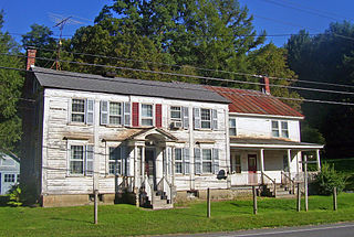
West Stockbridge is a town in Berkshire County, Massachusetts, United States. The town had a population of 1,343 at the time of the 2020 United States Census. It is part of the Pittsfield, Massachusetts Metropolitan Statistical Area.

Mansfield Center, Massachusetts Census-designated place in Massachusetts, United States

Mansfield Center is a census-designated place (CDP) in the town of Mansfield in Bristol County, Massachusetts, United States. The population was 7,360 at the 2010 census.

Pinehurst, Massachusetts Census-designated place in Massachusetts, United States

Pinehurst is an unincorporated village and census-designated place (CDP) in the town of Billerica, Middlesex County, Massachusetts, United States. The population was 7,152 at the 2010 census. It is located in the southeastern part of town along Massachusetts Route 3A between the Shawsheen River and the Burlington town line.

Marshfield Hills, Massachusetts Census-designated place in Massachusetts, United States

Marshfield Hills is a census-designated place (CDP) in the town of Marshfield in Plymouth County, Massachusetts, United States. The population was 2,356 at the 2010 census. The historic center of the village has been designated a historic district and listed on the National Register of Historic Places.

Canaan, New York Town in New York, United States

Canaan is a town in Columbia County, New York, United States. The population was 1,710 at the 2010 census. The town is in the northeastern part of the county.

Claverack-Red Mills, commomly known as Claverack, is a census-designated place (CDP) in Columbia County, New York, United States. The population was 913 at the 2010 census.

Stockbridge is a town in Madison County, New York, United States. The population was 2,103 at the 2010 census. The name is derived from a group of Native Americans.

Saugerties South, New York CDP in New York, United States

Saugerties South is a hamlet in Ulster County, New York, United States. The population was 2,218 at the 2010 census.

Adams (CDP), Massachusetts Census-designated place in Massachusetts, United States

Adams is a census-designated place (CDP) located in the town of Adams in Berkshire County, Massachusetts, United States. The population was 5,515 at the 2010 census, out of 8,485 in the entire town of Adams.

Great Barrington (CDP), Massachusetts Census-designated place in Massachusetts, United States

Great Barrington is a census-designated place (CDP) located in the town of Great Barrington in Berkshire County, Massachusetts, United States. The population was 2,231 at the 2010 census, out of 7,104 in the entire town of Great Barrington.

Lee (CDP), Massachusetts Census-designated place in Massachusetts, United States

Lee is a census-designated place (CDP) located in the town of Lee in Berkshire County, Massachusetts, United States. The population was 2,051 at the 2010 census, out of 5,943 in the entire town of Lee.

Williamstown (CDP), Massachusetts Census-designated place in Massachusetts, United States

Williamstown is a census-designated place (CDP) in the town of Williamstown in Berkshire County, Massachusetts, United States. The population of the CDP was 4,325 at the 2010 census, out of 7,754 in the entire town.

Belchertown (CDP), Massachusetts Census-designated place in Massachusetts, United States

Belchertown is a census-designated place (CDP) comprising the central village in the town of Belchertown in Hampshire County, Massachusetts, United States. The population was 2,899 at the 2010 census, out of a total town population of 14,649. It is part of the Springfield, Massachusetts Metropolitan Statistical Area.

Ware (CDP), Massachusetts Census-designated place in Massachusetts, United States

Ware is a census-designated place (CDP) comprising the main village in the town of Ware in Hampshire County, Massachusetts, United States. The population of the CDP was 6,170 at the 2010 census, out of a total town population of 9,872. It is part of the Springfield, Massachusetts Metropolitan Statistical Area.

Lenox, Massachusetts Town in Massachusetts, United States

Lenox is a town in Berkshire County, Massachusetts, United States. Set in Western Massachusetts, it is part of the Pittsfield Metropolitan Statistical Area. The population was 5,095 at the 2020 census. Lenox is the site of Shakespeare & Company and Tanglewood, summer home of the Boston Symphony Orchestra. Lenox includes the villages of New Lenox and Lenoxdale, and is a tourist destination during the summer.

References

  1. "2020 U.S. Gazetteer Files". United States Census Bureau. Retrieved May 21, 2022.
  2. "Geographic Identifiers: 2010 Demographic Profile Data (G001): Lenox CDP, Massachusetts". U.S. Census Bureau, American Factfinder. Archived from the original on February 12, 2020. Retrieved December 20, 2013.
  3. "US Gazetteer files: 2010, 2000, and 1990". United States Census Bureau. 2011-02-12. Retrieved 2011-04-23.
  4. "Census of Population and Housing". Census.gov. Retrieved June 4, 2016.
  5. "U.S. Census website". United States Census Bureau . Retrieved 2008-01-31.