
Berkshire County is a county on the western edge of the U.S. state of Massachusetts. As of the 2010 census, the population was 131,219. Its largest city and traditional county seat is Pittsfield. The county was founded in 1761.

Alford is a town in Berkshire County, Massachusetts, United States. It is part of the Pittsfield, Massachusetts Metropolitan Statistical Area. The population was 494 at the 2010 census.

Stockbridge is a town in Berkshire County in western Massachusetts, United States. It is part of the Pittsfield, Massachusetts, Metropolitan Statistical Area. The population was 1,947 at the 2010 census. A year-round resort area, Stockbridge is home to the Norman Rockwell Museum, the Austen Riggs Center, and Chesterwood, home and studio of sculptor Daniel Chester French.

West Stockbridge is a town in Berkshire County, Massachusetts, United States. It is part of the Pittsfield, Massachusetts Metropolitan Statistical Area.

Great Barrington is a town in Berkshire County, Massachusetts, United States. It is part of the Pittsfield, Massachusetts Metropolitan Statistical Area. The population was 7,104 at the 2010 census. Both a summer resort and home to Ski Butternut, a ski resort, Great Barrington includes the villages of Van Deusenville and Housatonic.

The Berkshires are a highland geologic region located in the western parts of Massachusetts and northwest Connecticut. The term "Berkshires" is normally used by locals in reference to the portion of the Vermont-based Green Mountains that extend south into western Massachusetts; the portion extending further south into northwestern Connecticut is grouped with the Connecticut portion of the Taconic Mountains and referred to as either the Northwest Hills or Litchfield Hills.
Beautification is the process of making visual improvements to a town, city, or urban area. This most often involves planting trees, shrubbery, and other greenery, but frequently also includes adding decorative or historic-style street lights and other lighting and replacing broken pavement, often with brick or other natural materials. Old-fashioned cobblestones are sometimes used for crosswalks; they provide the additional benefit of slowing motorists.

The Taconic Mountains or Taconic Range are a range of the Appalachian Mountains, running along the eastern border of New York State and adjacent New England from northwest Connecticut to western Massachusetts, north to central western Vermont. A physiographic region of the larger New England province, the range includes notable summits, including its high point, 3,840 feet (1,170 m) Mount Equinox In Vermont, and 3,489 feet (1,063 m) Mount Greylock, the highest point in Massachusetts.

The Boston and Albany Railroad was a railroad connecting Boston, Massachusetts to Albany, New York, later becoming part of the New York Central Railroad system, Conrail, and CSX Transportation. The line is currently used by CSX for freight. Passenger service is still provided on the line by Amtrak, as part of their Lake Shore Limited service, and by the MBTA Commuter Rail system, which owns the section east of Worcester and operates it as its Framingham/Worcester Line.

The Ice Glen is a ravine in the southeast area of Stockbridge, Massachusetts. The park is essentially a lush, untended, romantic landscape consisting of piled rocks thick with mosses. Ice Glen derives its name from the fact that ice can persist at the bottom of deep rock crevices there into the summer. Its north-south orientation protects the glen from much direct sunlight. Surrounding the glen is an old growth forest, rare in New England.

The Test Way is a 44-mile (71 km) long-distance footpath in England from Walbury Hill in West Berkshire to Eling in Hampshire, which follows much of the course of the River Test.
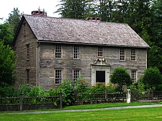
The Mission House is an historic house located at 19 Main Street, Stockbridge, Massachusetts. It was built between 1739 and 1742 by a Christian missionary to the local Mahicans. It is a National Historic Landmark, designated in 1968 as a rare surviving example of a colonial mission house. It is now owned and operated as a nonprofit museum by the Trustees of Reservations.

The Elm–Maple–South Streets Historic District is a historic district encompassing part of the historic downtown of Stockbridge, Massachusetts. The most prominent parts of Stockbridge lie within the Main Street Historic District, which abuts this district to the north. The southern boundary of this district is the railroad tracks that run parallel to the Housatonic River. The eastern boundary of the district is Laurel Hill, a wooded park overlooking the town, and the western boundary is a terraced shelf in the plains of the river. The district includes properties on Depot, Elm, Maple, and South Streets, and Laurel Lane. Unlike Main Street, this district consists of more densely place residences, and narrower roads containing businesses just off Main Street. Its buildings were mostly constructed during the late 19th and early 20th centuries, and partially reflect Elm Street's function as an industrial part of the town. The district was added to the National Register of Historic Places in 2004.

The Main Street Historic District is a historic district encompassing the scenic and historic portions of Main Street in Stockbridge, Massachusetts. The downtown portion of Main Street is widely recognizable due to its use by Norman Rockwell in his 1967 painting, Main Street, Stockbridge at Christmas. The central portion of Main Street is a broad street with wide green lawns, anchored by a traditional New England town center containing a church and municipal buildings. Along this part of Main Street is the Mission House, a National Historic Landmark that is one of oldest buildings in Stockbridge, dating to the early 1740s. Further to the west the road is more rural, and the district's western boundary is at the crossing of Main Street over the Housatonic River. The eastern part of the district includes the retail heart of the town, including the Red Lion Inn and several blocks of shops. The far eastern part of the district is Laurel Hill, a wooded park with views of the town center. The district was added to the National Register of Historic Places in 2002.

Old Curtisville Historic District encompasses village center of Interlaken in Stockbridge, Massachusetts. It is historically significant as the site of the first wood-based newsprint paper mill in the United States, and has a well-preserved collection of late 18th and early 19th-century architecture. It was listed on the National Register of Historic Places in 1976.

Yokun Ridge is a ridge in the Taconic Mountains in Berkshire County, Massachusetts, consisting of a well-defined series of contiguous peaks including West Stockbridge Mountain and Lenox Mountain. The name "Yokun Ridge" was invented for the area in 1971 by a land conservation and environmental advocacy organization called the Berkshire Natural Resources Council, and was accepted in 2009 by the United States Board on Geographic Names. Yokun Ridge is 9 miles (14 km) long and contains a conservation planning area called the Stockbridge-Yokun Ridge Reserve designated in 1993 by the U.S. Forest Service under its Forest Legacy Program. The ridge is notable for outdoor recreation and scenic beauty, as well as its conserved land and proximity to the tourist destinations of Lenox and Stockbridge. Yokun Ridge is located within West Stockbridge, Stockbridge, Lenox, Richmond, and Pittsfield, Massachusetts. Approximately one-third of the ridge is protected as open space reserve, municipal watershed, and wildlife sanctuary.

Stockbridge Bowl, also known as Lake Mahkeenac, is a 372-acre (1.51 km2) artificially impounded body of water that is 4 km (2.5 mi) north of the village of Stockbridge, Massachusetts. Above the lake’s north side with sweeping views to the south is Tanglewood, the summer home of the Boston Symphony Orchestra.

Vermont Route 118 (VT 118) is a state highway in the U.S. state of Vermont. The highway runs 28.549 miles (45.945 km) from VT 100 in Eden north to VT 108 in Berkshire. VT 118 connects several towns in northern Lamoille County and eastern Franklin County, including the covered bridge–rich town of Montgomery. The town of Berkshire maintains the highway north of VT 105.

Williams High School was a public high school located in the town of Stockbridge in the Berkshire Hills of western Massachusetts. Its history evolved from the town's earliest schools founded before and shortly after the American Revolutionary War. Students from Stockbridge, its small villages of Interlaken, Glendale and Larrywaug, and from the nearby town of West Stockbridge attended Williams High School. In April 1968 the school closed, when its students transferred to a new regional high school located in the town of Great Barrington.

Searles High School was a public high school located in Great Barrington in the Berkshire Hills of western Massachusetts. Students attended the school from Great Barrington, the villages of Housatonic, Van Deusenville and other communities in the southern Berkshire region. Searles High School was founded in 1898 and closed in 1968, when its students transferred to a new regional high school.
